| Southern Entrance: |
From Indiana southwest of Niles in Berrien County |
| Northern Terminus: |
I-75 at Exit 336, three miles south of Mackinaw City |
| Length: |
355.275 miles |
| Maps: |
Route Map of US-31
Map of US-31 Freeway in Berrien County
Progress Map of US-31 Freeway in Berrien County
Niles Area Trunklines Map, 2010– |
| Notes: |
US-31 is a major highway corridor leading up the western side of the Lower Peninsula, connecting the cities of South Bend, Ind., Benton Harbor/St Joseph, Holland, Muskegon, Ludington, Traverse City and Petoskey. Approximately 40 percent of US-31 (about 145 miles) is currently constructed to freeway standards, with an additional freeway segment proposed for the future. US-31 is a major artery carrying tourist traffic to Michigan's North Country and, as such, has been experiencing congestion issues in such northern cities as Traverse City and Petoskey for many years now. Improvements in those areas may not be forthcoming, however. |
| |
The US-31 corridor has seen a variety of major activity in each of the last five decades and that activity will continue for at least another two decades! In the 1950s, the highway saw major upgrades between Holland and Grand Haven and even some of the first freeway mileage built in West Michigan. The 1960s saw the freeway mileage extended from Benton Harbor/St Joseph to Holland and from Grand Haven toward Oceana Co. The 1970s saw major freeway projects push ever closer to Ludington through Oceana Co and the beginnings of the freeway upgrades in Berrien Co, which all continued into the 1980s. The 1990s continued that progress, with more of US-31 converted to freeway in Berrien and Mason Cos with even more freeway mileage added in the the first decade of the 21st Century. Ultimately in late-2022, the final three-mile segment of the US-31 freeway in Berrien Co was completed and opened to traffic, completing an essentially continuous freeway segment from Plymouth, Indiana (~25 miles south of South Bend) northerly to Holland, Michigan. Should the Ottawa Co freeway gap be bridged in the future, it would result in a 213-mile long freeway between Plymouth, Indiana and Ludington, 180 miles of which would be in Michigan. |
| |
Some of the ongoing projects noted above have not been without controversy. In Berrien Co, the completion of the freeway gap there was delayed for environmental reasons and the design and route of the freeway were altered as well. Further north in Ottawa Co, the decision to route the US-31 freeway though the largely-agricultural central portion of that county has raised howls of protest. Farther north, the proposed US-31 bypasses of the cities of Traverse City and Petoskey have had no shortage of controvery as well, to the extent that, at present, MDOT is comitted to not building the long-proposed bypasses of those two cities. Full details on each of these US-31 projects can be found on their own pages:
|
| |
In "State Trunkline Needs, 1960–1980," a set of maps prepared by the State Highway Dept's Office of Planning, Programming Division in 1960 showing possible additions, upgrades and improvements to the state trunkline system over the ensuing twenty years, MSHD staff recommended many changes to the route of US-31 during that timeframe, including:
- Construction of a US-31 freeway from the Indiana state line to St Joseph. The first section looks much like the present-day US-31 freeway west of Niles, with the exception of an interchange at Bertrand Rd and the present US-12 interchange was to have been a freeway-to-freeway interchange with the proposed US-112 freeway. A BUS US-31 routing was proposed to serve downtown Niles. Farther north, interchanges were planned at Rangeline and Shawnee Rds (instead of the current one at Snow Rd) and the proposed freeway was to have stayed to the west of the existing US-31/US-33 route after passing Berrien Springs, with interchanges at Scottdale Rd and I-94 near Lincoln Rd. The freeway was to have continued north-northwesterly along the path of the long-proposed BL I-94 "penetrator" route, with the freeway merging back into Niles Ave at Washington Ave where US-31 was proposed to continue into downtown St Joseph via the existing street routing. With the exception of the BUS US-31 routing at Niles, all of the existing US-31/US-33 route was to have been turned back to local control. In the end, while a US-31 freeway was built through much of Berrien Co, north(west) of Berrien Springs, it took on a much different route than was envisioned in 1960.
- Conversion of the route of US-31 through Ottawa Co to a full freeway facility, with additional interchanges at a relocated M-40 in Holland, at Port Sheldon Rd between Holland and West Olive, at Lake Michigan Dr (then designated as M-50 and a proposed turnback candidate through all of Ottawa Co!), and Lincoln St south of Grand Haven. No interchanges or grade separations were shown in the City of Grand Haven, however, so the exact plans for freeway conversion through the city weren't clear from the maps. In the end, none of these proposed upgrades were ever completed.
- Conversion of US-31 through Muskegon Co to a full freeway, although with fewer interchanges in the Muskgon area than were eventually built. As much of this segment was either completed, under construction or in planning at the time these maps were issued, most of the proposed upgrades in Muskegon Co were eventually carried out.
- Construction of a mostly new-alignment US-31 freeway for the length of Oceana Co, although in a rather different configuration than was built in the 1970s. Instead of crossing to the west side of the existing route of US-31 (Oceana Dr) at the Muskegon/Oceana Co line, the proposed freeway would have run to the east of much of the existing US-31 route with interchanges at Rothbury, relocated M-82 (now M-20) near New Era, at existing M-82/Johnson Rd near Shelby, and at both Polk and Tyler Rds east of Hart. North of Hart, the proposed US-31 freeway would have bent to the west to an interchange with existing US-31 (Oceana Dr) at BUS US-31/Monroe Rd, before turning north and following the existing alignment of US-31 along Oceana Dr to the Mason Co line with interchanges at Cypress Ave and the north jct of BUS US-31 northeast of Pentwater. In Mason Co, the proposed US-31 freeway would have jogged east before turning back north again to run appoximately 1/2 mile east of the existing route (along Pere Marquette Hwy) due northerly to an interchange at US-10 east of Ludington. There, the freeway would have turned northeasterly, through an interchange at Fountain Rd, before it turned to run due northerly again at Freeman Rd into Manistee Co where it would have interchanged with a proposed BUS US-31 routing for Manistee at the existing alignment four miles south of downtown. (Continued in next bullet)
- Construction of a new-alignment freeway from the proposed BUS US-31 interchange south of Manistee northeasterly through the Village of Stronach (with an interchange at Stronach Rd), then turning due northerly to an interchange with M-55 east of East Lake. The freeway would have turned northeasterly again after crossing the Manistee River cutting through Blacker Airport to a combined interchange for the Manistee BUS US-31 and M-22 at the location of the existing US-31 & M-22 junction. The proposed US-31 freeway would have stayed west of the existing route past Onekama (with an interchange at 8 Mile Rd) before crossing back over the existing route south of Bear Lake near 11 Mile Rd (with an interchange) then passing to the east of Bear Lake through an interchange at 13 Mile Rd. The freeway would have continued northeastly skirting Glovers Lake (with an interchange at Glovers Lake Rd) and into Benzie Co where it would interchange with M-115 and a proposed BUS US-31 routing for Beulah/Benzonia/Honor near King Rd, continuing through an interchange at Homestead Rd near Zimmerman Rd and on to an interchange with the proposed Beulah/Benzonia/Honor BUS US-31 route at existing US-31 about ½ mile east of Valley Rd. (Continued in next bullet.)
- Construction of a new-alingment freeway from the proposed Beulah/Benzonia/Honor BUS US-31 route at existing US-31 east of Honor turning due easterly to parallel the existing US-31 about one mile to the north through an interchange at Lake Ann Rd before entering Grand Traverse Co and interchanging with an extended M-137 near Cedar Hedge Lake. The proposed freeway would continue due easterly to interchanges with M-37 and a proposed Traverse City BUS US-31 route at Chums Corners and another at River Rd & Beitner Rd just to the east. The freeway would then swing northeasterly past Traverse City through an interchange at Garfield Rd (at Potter Rd) to an interchange with M-72 and the proposed BUS US-31 east of Traverse City at roughly the Mount Holiday Ski Area. The combined US-31/M-72 freeway would continue due easterly from there for approximately 1½ miles to an interchange with M-72 continuing easterly as a full freeway toward Kalkaska and M-113 coming in from the south on a completely new alignment (instead of turning westerly through Kingsley). At this point, US-31 would then split off M-72 to head northerly as a full freeway paralleling Lautner Rd ¼ mile to the west before merging back with the existing US-31 route about two miles north of Acme where the freeway would end.
- Conversion of the existing alignment of US-31 from the northern end of the proposed freeway two miles north of Acme to the Grand Traverse/Antrim Co line south of Elk Rapids.
- Conversion of the existing US-31 route from Charlevoix-Boyne City Rd northeast of Charlevoix into Emmet Co to the western limits of Petoskey near Resort Pike.
- Construction of a notherly extension of the proposed US-131 freeway from Petoskey to I-75 south of Mackinaw City. This would have resulted in US-31 continuing through the heart of downtown Petoskey via Mitchell St, which itself would be converted to a full freeway starting at the eastern Petoskey city limit. US-31 would interchange with the US-131 freeway bypass at approximately Mitchell St & Division Rd, where US-31 would then continue northeasterly through an interchange with the existing route of US-31 east of Round Lakeas well as an interchange at Hathaway Rd (at North Conway Rd), where M-68 would split off and run easterly via a straighened Powers Rd to Alanson. The proposed US-31 freeway would continue roughtly north through interchanges at Brutus Rd, Robinson Rd (west of Pellston), Leavering Rd (west of Levering), and Gill Rd about ½ mile west of Carp Lake. The freeway was then to have continued northeasterly to an interchange at I-75 at roughly its current northern terminus.
|
| |
Some of the historical information presented here was clarified by Marc Fannin... many thanks! |
| History: |
1920s – Before the debut of the US Highway system in 1926, the route of present-day US-31 in Michigan consisted of two state highways: M-58, from a connection with Indiana SR-1 at the state line south of Niles to M-11 (later US-12) in St Joseph; and M-11 from St Joseph up the entire western shore of the Lower Peninsula to end with M-10 (later US-23) in downtown Mackinaw City. |
| |
1927 – As the US-31 designation replaces the trunkline routings noted above, the former designations—M-58 and M-11—go on to exist on other routes elsewhere in the state. Also, the US-31 designation is chosen over the US-23 designation to run across the state highway ferries at the Straits of Mackinac—the first route designation to cross the Straits. US-31 runs an additional nine miles northerly from St Ignace to end at US-2 at Rogers Park. US-31 is one of only three route designations to ever cross the Straits. The others will be US-27 (1957–1960) and I-75 (1960–). |
| |
1927 – Several changes along US-31 this year:
- (Mar 28) – Several small realignments and relocations in western Charlevoix Co straighten out the route of US-31. Most of the former alignments—those portions not obliterated completely—are turned back to local control, including Old Orchard Tr and Schmidt Rd, Ferry Rd easterly to Beatty Rd and Beatty northerly to US-31, Cedarview Dr and Clipperview Dr north of Cedarview, and others.
- (June 30) – A new direct Grand River crossing from Grand Haven northerly into Ferrysburg via an electrically-operated swing bridge was completed on November 11, 1924, replacing an old hand-operated interurban bridge to the east. On this date, that bridge and its approach roadways were incorporated into the state trunkline system and the former route is officially cancelled.
- (Aug 20) – A slight realignment occurs in Muskegon Heights. Entering the city from the southeast via Merriam Ave, the route formerly continued via Merriam to Summit Ave, then westery via Summit for one block before turning northerly along Peck St toward downtown Muskegon. Now, US-31 curves westerly from Merriam Ave onto Lincoln Ave for two blocks, then turns northerly via Peck St. The former route along Merriam from Lincoln to Summit and along Summit from Merriam to Peck is turned back to local control.
|
| |
1928 (Dec 18) – The 0.5 mile segment of heretofore city-maintained US-10/US-31/E Ludington Ave on the east side of the city of Ludington from Washington Ave easterly to the city limit at Jackson Rd is officially established as a state trunkline highway route. The remainder of US-10 along Ludington Ave into downtown Ludington as well as US-31 southerly along Washington Ave, Second St, Madison Ave and Sixxth St to Taylor Ave remain marked-and-maintained routes along city-controlled streets. |
| |
1929 – A trio of realignments and establishments in 1929:
- (July 5) – The stair-stepping route of US-31 from the north limits of Saugatuck northeasterly for 2.2 miles is turned back to control when a new, more directly 1.4-mile long alignment is established as a state trunkline route. Construction on the new alignment, however, may not have been complete until 1930.
- (Aug 19)
 – Since debuting in Michigan two years prior, US-31 entered the state from Indiana and continued northerly into downtown Niles via Third St. The Third St route is cancelled as a state trunkline route while a new, parallel route to the east along Eleventh St is established as the new route for US-31. However, as the Eleventh St route is not yet complete and open to traffic, Third St remains a "marked-and-maintained" trunkline route for the time being. – Since debuting in Michigan two years prior, US-31 entered the state from Indiana and continued northerly into downtown Niles via Third St. The Third St route is cancelled as a state trunkline route while a new, parallel route to the east along Eleventh St is established as the new route for US-31. However, as the Eleventh St route is not yet complete and open to traffic, Third St remains a "marked-and-maintained" trunkline route for the time being.
- (Aug 19) – The portion of US-31 from Oden northerly thorugh Alanson to south of Brutus in Emmet Co via Milton Rd/Milton St is turned back to local control when the present-day route is officially established as a state trunkline route. The new route is also 1⁄ 10 mile shorter than the former. Construction on the new route, however, is likely not complete until the next year.
|
| |
1930 (Apr–June) – On April 14 the State Adminisrative Board gives preliminary approval for a new easterly bypass of downtown Muskegon and Muskegon Heights. Then, on June 30 a 1.5-mile state trunkline route is officially established as a state trunkline highway route along Getty Ave beginning at Sherman Blvd and continuing southerly to Broadway Ave, then due southerly along a yet-to-be-constructed roadway to Norton Ave, continuing southerly via a minor roadway (to be upgraded) ending at the US-31 relocation on the north shore of Mona Lake nearing completion (present-day BUS US-31 in modern-day Norton Shores). The remainder of the future bypass route, while already in existence as locally-built roadway segments, will be officially established in the future. After pressure from business interests trying to keep tourist dollars from bypassing the city, highway officials reassure civic and business leaders when the new bypass is completed, the mainline US-31 route designation will remain on the Peck–Terrace–Clay–Ottawa route through the downtowns of Muskegon and Muskegon Heights with the bypass receiving an "optional" designation. |
| |
1930 (Aug 20) – A realignment in southwest Emmet Co relocates US-31 onto a more direct alignment from the Charlevoix Co line at Bay Shore easterly for 3.4 miles to just east of Townsend Rd west of Petoskey. The former route runs via present-day Old US-31 but, in an interesting twist, is not cancelled as a state trunkline route (and transferred to county control) while the new alignment is also not officially established as a trunkline. (See also the November 7, 1949 listing.) |
| |
1930 (Sept 10)  – The southernmost 2.65 miles of relocated US-31 south of Niles along the Eleventh St alignment from the Indiana state line northerly to Bell Rd are completed and opened to traffic. At Bell Rd, US-31 traffic is temporarily diverted back to its former alignment along S Third St (Bell Rd is upgraded for its temporary use as a trunkline connector) while the remainder of the relocation south of Niles is being constructed. This segment of trunkline was established about eleven months prior. – The southernmost 2.65 miles of relocated US-31 south of Niles along the Eleventh St alignment from the Indiana state line northerly to Bell Rd are completed and opened to traffic. At Bell Rd, US-31 traffic is temporarily diverted back to its former alignment along S Third St (Bell Rd is upgraded for its temporary use as a trunkline connector) while the remainder of the relocation south of Niles is being constructed. This segment of trunkline was established about eleven months prior. |
| |
1930 (Sept 10) – The route of US-31 undergoes a realignment southeast of Whitehall in Muskegon Co. Formerly turning northwesterly via Bell Rd, then westerly along Lakewood Rd and northerly via Durham Rd to Whitehall Rd, the new route along present-day Whitehall Rd is officially established as a state trunkline route and likely opens to traffic soon after. The former route is turned back to local control. |
| |
1930 (Dec 2) – A new alignment for US-31 entering Manistee from the south is officially established, although is not yet constructed. US-31 approaches Mansitee from the south via Grant Hwy, then follows Nelson St into the Oak Hill neighborhood, continuing northerly via Main St, westerly on 13th St, northerly along Vine St, westerly via Eighth St, northerly on Kosciusko St, westerly along Fifth St, northerly via Sibben St, westerly on First St, northerly along Division St, northeasterly via River St, then northwesterly along Smith St across the "Smith Street Bridge" spanning the Manistee River. (*whew*) The 3.2-mile long new alignment departs Grant Hwy at Preuss Rd curves northwesterly running northeast of Canfield Lake (and through modern-day Butcher Lake), merging into Maple Rd at Red Apple Rd (to this point, the roadway is yet to be constructed), continuing northerly into Manistee via Maple Rd/Maple St to First St, then easterly along First St to the existing route of US-31 at Division St. The 1.3 miles of Nelson St–Main St south of the city in the Oak Hill area is cancelled as a state trunkline highway route, although it remains part of the signed route of US-31, as its the remainder of the starstep route as noted above until the the 3.2-mile long newly-established route—which is now the official route of US-31 into Manistee from the south—is constructed. |
| |
1930–33 – A major realignment for US-31 between Benton Harbor and South Haven is constructed and opened to traffic as well as officially established as a trunkline route in several steps over the course of three years:
- 1930 (Sept 24) – The State Administrative Board approves the construction of the northernmost 18½ miles of a new scenic shoreline route for US-31 between St Joseph and South Haven, beginning at Eaman Ave west of the hamlet of Riverside northeasterly parallelling the Lake Michigan shoreline to the existing route of US-31 (present-day M-140) south of South Haven. The portion southwesterly from Eaman Ave into St Joseph is yet to be approved or established. The contracts for paving and completing this 18.528-mile segment total more than $1.06 million.
- 1930 (Nov 22–Dec 23) – The first two sections of the new scenic route for US-31 between St Joseph and South Haven are established. First, on November 22, the 1.7-mile segment from the northern end of the so-called "Somerleyton Cut-Off" or proposed M-139 bypass route (established December 1929) at Paw Paw Ave northeasterly to Eaman Ave is established as a state trunkline route. Then on December 23, the 5.563-mile portion from Eaman Ave northeasterly to the Berrien/Van Buren Co line is officially added to the system.
- 1931 (Oct 14) – With the completion of the last mile of construction needed to link the new route with existing Paw Paw Ave north of Benton Harbor now completed, the entire so-called "super-scenic" US-31 highway between Benton Harbor and South Haven is opened to traffic, with a total project cost of $1.66 million. Attending the ribbon cutting on the north end of Paw Paw Ave where it meets the new shoreline route is State Highway Commissioner Grover C Dillman. After the ribbon-cutting, the entourage with Dillman proceeds to the north end of the new section at South Haven where another celebration occurs for the opening of the new highway. The new 18½ mile highway begins on the existing route south of South Haven (present-day M-140) and continues southwesterly paralleling the Lake Michigan coast, never straying more than a mile from the lake overall and never more than 1,600 feet in the Berrien Co stretch, to an intersection with Paw Paw Ave north of Benton Harbor. There, US-31 is redirected southerly along Paw Paw Ave into downtown Benton Harbor where it turns westerly along its former route via US-12/Main St into St Joseph. The former route of US-31 from south of South Haven southerly through Covert to US-12 in Watervliet is retained as a state trunkline route and given the designation M-140. Plans are already afoot to continue the new "super-scenic" highway route southwesterly from Paw Paw Ave toward a direct connection with US-31 along Main St in downtown St Joseph, including a new movable bridge spanning the St Joseph River to replace the aging and deficient exisitng Main St bridge, and while some state and local officials state the new bascule bridge will be completed by 1933, Dillman is unwilling to pin a definite timeframe on the construction. The portion of the Paw Paw Ave routing for US-31 from Riverside Rd to US-12 in Benton Harbor is not officially established as a state trunkline route, as the officially established route for M-139 from December 1929 continues due southerly along the section line to a connection with Fair Ave on the east side of Benton Harbor. There are long-range plans to construct a new trunkline along this direct routing in the future with plans to route US-31 around the twin cities via the M-139 route.
- 1931 (Oct 23) – The 11.277-mile portion of the route from the Berrien/Van Buren Co line northerly to existing US-31 (present-day M-140) south of South Haven is established as a state trunkline route, nine days after opening to traffic.
- 1931 (Late) – A short, approximately 0.2-mile long southwesterly continuation of the US-31 "super-scenic" highway is completed from Paw Paw Ave to the Hagar/Berrien Twp line at Zoschke Rd, although since this new spur route essentially does not go anywhere, it remains an un-numbered state trunkline route for now.
- 1932 (Feb 6) – President Herbert Hoover signs a bill into law which permits the State of Michigan or Berrien Co to construct the proposed bascule bridge over the St Joseph River to ultimately complete the US-31 "super-scenic" highway between St Joeph and Benton Harbor. Permission to construct the span is also given by the War Department, as the bridge will cross a navigable waterway.
- 1932 (Oct 29) – The 0.2-mile segment of the future portion of the US-31 "super-scenic" highway north of St Joseph from Zoschke Rd northeasterly to Paw Paw Ave (where US-31 now turns southerly into Benton Harbor) is officially established as a state trunkline route.
- 1933 (July 21–31) – A addtional 1½ mile section of the US-31 "super-scenic" shoreline route between St Joseph and South Haven is completed and opened to traffic on July 21 from north of Rocky Gap Rd to Zoschke Rd just south of Paw Paw Ave—but only local traffic, since US-31 will remain routed into Benton Harbor from the north via Paw Paw Ave until a planned bascule span of the Saint Joseph River on the north edge of downtown Saint Joseph is constructed, linking the St Joseph and scenic shoreline segments. While the roadway segment in question opens in June, the precise date of establishment by the State Highway Dept is currently unknown. In addition, a double curve along Paw Paw Ave—the "temporary" conenctor route for US-31 between the "super-scenic" shoreline route and Benton Harbor—is eliminated and replaced by a shorter and safer curve crossing a deep fill. The realignment in completed on July 31 and increases the safety of the Paw Paw Ave route.
- While the expectation is that construction will soon begin on a new bascule bridge spanning the St Joseph River replacing the existing narrow, outdated State St bridge (connecting to present-day Upton Dr on the north side of the river) with a projected completion by 1935, this does not occur and it would be a decade-and-a-half before the bridge would be completed.
|
| |
1931 (May 19) – Act 131 of 1931—the Dykstra Act—is passed allowing the State Highway Dept to take over control of state highways running into and through incorporated cities, thereby officially incorporating them as state trunkline highways. The following segments of formerly city-controlled streets are established as state trunkline highway routes as part of US-31:
- In Niles: 1.05 mile through downtown consisting of 0.65 mile of concurrent M-60 (future US-112) along E Main St from Eleventh St to Front St and 0.4 mile of Front St from Main St northerly to approximately the Michigan Central RR overpass
- In Saint Joseph: The 0.4 mile segment of Niles Ave from Winchester Ave northerly to US-12/Main St and the 1.1-mile concurrent segment with US-12 along Main St, Ship St and Wayne St from Niles St to the St Joseph River bridge.
- In Benton Harbor: 1.9 miles of concurrent US-12/US-31 along Main St, Water St and Territorial Rd from the Saint Joseph River easterly through downtown to Fair Ave.
- In South Haven: For 1.3 miles from the cnr of Phillips St, Green St & Broadway St, northerly via Broadway St, northwesterly via Dyckman Ave, then north-northeasterly along North Shore Dr to Brockway Ave.
- In Holland: The 1.0 miles of River Ave from Thirteenth St northerly through downtown to the north city limits at the Black River bridge.
- In Muskegon: 1.0 mile through downtown northwesterly along Terrace St from Peck St to Clay Ave, then northeasterly along Clay Ave from Terrace St, continuing via Ottawa St to Jackson Ave.
- In Ludington: The 0.8 mile portion in south Ludington along Sixth St from Taylor St to Madison St, via Madison St from Sixth St to Second St, along Second St from Madison St to Washington Ave and via Washington Ave from Madison St to Dowland St.
- In Manistee: A 1.4-mile segment running northerly along DIvision St from FIrst St to River St, easterly via River St from Division to Smith St, northwesterly along Smith St across the Smith Street Bridge, then northerly via Cleveland St and Arthur St to the north city limit.
- In Traverse City: A 1.2-mile segment through downtown consisting of the 0.7 mile of Union St from Twelfth St northerly to Front St and the 0.5 mile portion of Front St from Union St to Wellington St.
- In Petoskey: A 0.5-mile segment through downtown consisting of Mitchell St from Liberty St easterly to Howard St and Howard St from Mitchell St northerly to Bay St.
|
| |
1931 (July 10) – Less than two months after the Smith Street Bridge spanning the Manistee River in central Manistee is officially established as a state trunkline route (due to passage of Act 131 of 1931—the Dykstra Act), the hand-operated, drum-bearing swing bridge which opened in 1894 is destroyed when the coal barge J.E. Savage becomes grounded under the bridge and the tender, not knowing the barge is still under the swing span, closes the bridge, destroying its underpinnings and causing its collapse. The bridge tender falls 60 feet due to the collapse, later passing away from the injuries. "Rudimentary trusses" are placed across the collapsed span to allow for pedestrian crossing while vehicular traffic is detoured to the Maple Street Bridge, ¼ mile downstream. |
| |
1931 (July 13) – After waiting a couple years for fill dirt to finish settling in the swampy soils at the eastern end of Mona Lake, a realignment of US-31 is finally paved and opened to traffic south of Muskegon Heights in Muskegon Co. The short, ½-mile realignment takes the highway farther away from the lake between Grand Haven Rd and the future southerly extension of Getty Ave and includes a new bridge spanning Black Creek. The former roadway is, in part, abandoned as a public roadway, while the remainder becomes an access roadway into Hidden Cove Park. The old US-31 bridge spanning Black Creek is left in place as an amenity for park users. |
| |
1931 (July 14, 17) – A new US-31 route across the Muskegon River delta north of downtown Muskegon (the "east arm" or northbound lanes of the present-day M-120/Veterans Memorial Causeway) is completed and opened to traffic between the northern end of Ottawa Ave in Muskegon and jct M-20 at North Muskegon on July 14. The former route is obliterated as a public highway, while a segment of the later "west arm" (the future southbound lanes) will be built atop a portion of this former, obliterated route. The new route is officially established as a state trunkline highway route three days later on July 17. |
| |
1931 (July 22) – A one mile northerly "extension," of sorts, of Pere Marquette Hwy in Mason Co east of Ludington from 6th St northerly to US-10/US-31/Ludington Ave is completed and added to the state trunkline system as US-31A, providing an easterly bypass of Ludington. The mainline US-31 route still turns westerly via 6th St, northerly on Madison St, westerly along 2nd St and northerly again via Washington Ave to US-10 at Ludington Ave where both US-10 and US-31 run easterly out of the city toward Scottville. The mile-long US-31A "cutoff" is approved by the State Administrative Board at its June 19 meeting. |
| |
1931 (Aug 31) – A brand-new alignment for US-31 is officially established from Beulah to Honor in Benzie Co, bypassing Benzonia in part. Beginning two blocks north of the notherly US-31 & M-115 jct in Benzonia, US-31 now veers easterly off Spring Valley St and enters Beulah via present-day Beulah Hwy, bypassing the downtown district. North of downtown Beulah, the new alignment overlaps the old one for a short distance from Benzie Blvd to Crystal Dr, but then veers northeasterly again and completes the trip into Honor via Beulah Hwy and Honor Hwy. The former route via Spring Valley St from Michigan St in Benzonia to Benzie Blvd in Beulah, along Benzie Blvd from Spring Valley to Beulah Hwy and then via Crystal Dr, Edenhill Rd, Worden Rd and Moss Rd from Beulah to west of Honor is turned back to local control. |
| |
1931 (Oct 14) – The final 1½ mile section of the Niles-to-Indiana state line realignment is completed and opened to traffic from M-60/Oak St in Niles southerly along Eleventh St to Bell Rd south of the city at the northern end of the new segment which was opened to traffic eleventh months earlier in September 1930. Completion of this northern portion had stalled at Brandywine Creek by slow progress in constructing an overpass spanning the Big Four (aka Cleveland, Cincinnati, Chicago and St. Louis or "Big Four") Railway just south of Brandywine St. With the overpass (which would be removed 4½ decades later) and the four-lane concrete completed between Brandywine Creek and M-60/Oak St, the section is able to open to traffic. The former route along Third St had been turned back to local control over two years prior and is no longer maintained as part of US-31. |
| |
1932 (Oct 25, 29) – The 3.5 mile remainder of the new Muskegon bypass route is established as a state trunkline route when the 2.8-mile segment of Getty St from Sherman Blvd northerly to Marquette Ave and the 0.7-mile segment of Marquette Ave from Getty St westerly to US-31/Ottawa Ave north of downtown Marquette are transferred to state control on October 29. The newly-constructed segment of Getty St between Sherman Blvd and Norton Ave and the upgraded roadway from Norton Ave southerly to US-31 at Mona Lake are completed and opened to traffic around this time as well. The new Getty–Marquette bypass route of Muskegon is designated as US-31A. The roadway itself is opened to traffic four days earlier on October 25. |
| |
1932 (Oct 29) – Three new location trunkline establishments occur along US-31:
- (Oct 29) – An easterly bypass of North Muskegon is officially established as a state trunkline in late 1932 and likely opens to traffic at the same time. Beginning at the eastern jct of US-31 & M-20 (cnr Whitehall Rd & Holton Rd-Lake Ave) the new route continues northwesterly back to the original alignment of US-31 at Witham Dr. The former route along Lake Ave and Center St to Ruddiman Ave is redesignated as the easternmost part of the new M-148 route leading to Muskegon State Park, while the portion along Center north of Ruddiman and along Witham Dr northerly to the new bypass is turned back to local control.
- (Oct 29) – A new route for US-31 entering Charlevoix from the southwest is established along its present-day route from Barnard Rd easterly, then curving northerly into the city to Carpenter Ave where it then continues northerly via Bridge St to M-66 at Garfield Ave. There, US-31 supplants the M-66 designation northerly for five blocks to Antrim St and the former route of US-31. The former route along Barnard Rd from US-31 northeasterly to Carpenter Ave is turned back to county control but will later be removed when the airport runways are built across it in later years. The former route in the city along Norwood Rd northerly to Sheridan St, then northerly via Sheridan to Antrim St and easterly via Antrim to Bridge St is turned back to city control.
- (Oct 29) – A more direct routing for US-31 from Levering to Carp Lake is officially established as a state trunkline route on this date, however sources indicate construction on the 4.2 mile route is not complete until 1933, though traffic may have been allowed to use the unpaved alignment starting this year. The former route via Levering Rd westerly from US-31 to Reed Rd, northerly via Reed to Gil Rd and easterly along Gill to the new alignment of US-31 is turned back to local control.
|
| |
1932 (Nov 1) – The west arm of the US-31 "North Muskegon Causeway" (present-day M-120/Veterans Memorial Causeway) is completed and opened to traffic. A portion of the new southbound side of US-31 between North Muskegon and Muskegon through the Muskegon River delta is constructed atop the former route of US-31 through the area which existed prior to the completion of the east arm of the causeway, which opened to traffic in 1931 and now becomes the northbound lanes of US-31. |
| |
1933 (July 12) – Two US-31 route changes on the same day:
- A new, more direct alignment for US-31 is completed along the route of present-day Oceana Dr between Hayes and Water Rds, halfway between New Era and Shelby. The former route along Hayes Rd and Water Rd is turned back to local control on this date.
- Also on July 12, the new alignment of US-31 from northeast of Bay View northeasterly through Conway and Oden to south of Alanson in Emmet Co is officially established as a state trunkline route and the former route (that portion which does not lie underneath the new alignment), mostly Hiawatha Tr from M-131 (present-day M-119) to Conway, is turned back to local control. The new alignment was completed, however, during 1930 and it is unclear why the jurisdictional transfer takes place three years later.
|
| |
1933 (Nov 12, 2:00 pm) – The new $350,000 Manistee Memorial Bridge, named in tribute to the area's war veterans, is officially dedicated and opened to traffic as part of an elaborate ceremony attended by Murray D. Van Wagoner, State Highway Commissioner and a cadre of local officials. The new bascule span, which has a clearance of 120 feet across the Manistee River in downtown Manistee, replaces the collapsed Smith Street Bridge situated immediately upstream of the new span. Engineers state it's "the finest bascule type span in Michigan, outside Detroit. It embodies engineering improvements which place it in a class with the best concrete bridges in the country." (This 1933 bridge remains in services to the present-day.) |
| |
1934 (Oct 10) – Two 90° corners in the route of US-31 in western Allegan Co are bypassed by a new curving alignment. Formerly turning easterly from 70th St for one mile along 114th Ave, then northerly for 11⁄ 3 mile via 68th St, US-31 now follows the route of modern-day Blue Star Hwy from Glenn northeasterly. The former route along 114th Ave and 68th St, however, remains as an unsigned state trunkine for the time being and is turned back on August 30, 1937. However, the State Highway Dept notes they ceased maintenance on the former route as of January 7, 1935 as per letter dated December 19, 1934. |
| |
1935 (Jan 7) – A new route for US-31 in Ottawa Co from Grand Haven southerly to the Lake Macatawa outlet into Lake Michigan is established, closely following the shoreline of the Big Lake. This route would never see any construction whatsoever and it would be officially deleted 21 years later. |
| |
1936 (Late) – The final few miles of gravel-surfaced US-31 in Michigan, between Charlevoix and the intersection of Boyne City-Charlevoix Rd in Charlevoix Co., are hard-surfaced. |
| |
1936 (Dec 9) – A new shoreline route for US-31/M-72 is established along the East Arm of Grand Traverse Bay between Traverse City and Acme, beginning at the present-day Holiday Rd intersection and continuing northeasterly to the present-day 5 Mile Rd intersection. Not only does the new alignment bring the highway closer to the bay, it also removes a 90° turn and two railroad crossings. The former route along Holiday Rd easterly to 5 Mile Rd and then northerly via 5 Mile back to the the location is retained, however, for nearly a year. |
| |
1937 – Several realignments and route establishments during this year:
- (Aug 30, Sept 27) – On August 30, a new trunkline route for US-12/US-31 through downtown Benton Harbor is officially added to the state trunkline system along Main St from Water St easterly to Fair Ave, then northerly via Fair Ave to the existing route along Territorial Rd. The former trunkline route northerly from Main St via Water St and easterly along Territorial to Fair remained in system for nearly a month before being turned back to local control on September 27.
- (Aug 30) – A second new route established for part of US-31, this one an eastern bypass of Saugatuck in Allegan Co. The former route through downtown Saugatuck via Lake, Gulver, Butler, Francis and Holland Sts is turned back to local control. Sources seem to indicate, however, that construction on the new bypass may not be complete until 1938.
- (Aug 30) – Several sharp turns in the route of US-31 in Mason Co are replaced by a new, sweeping alignment for the highway southeast of Ludington. The former route along Meyers, Hesslund and Lenz Rds is turned back to local control.
- (Aug 30) – The former route of US-31/M-72 in the East Bay area east of Traverse City via Holiday and 5 Mile Rds, bypassed by a new alignment completed in 1936, is turned back to local control.
- (Aug 30, Dec 29) – The final segments of the new alignment of US-2 in Mackinac Co between Brevort and St Ignace are officially established as a state trunkline route on December 29 and likely open about the same time, however the former route of US-2 from Brevort easterly via Worth Rd to Moran, then southeasterly via Tahquamenon Tr (present-day M-123) to US-31 at Rogers Park is turned back to local control on August 30! The newly built highway takes US-2 along the Lake Michigan shoreline from Brevort, past Gros Cap, and into St Ignace. There, the US-2 routing supplants the US-31 designation northward to Rogers Park and the former route. While it could be assumed that either of these dates is when US-31 is removed from the U.P. and truncated back to the State Highway Ferry Docks in Mackinaw City, official State Highway Dept maps will continue to show US-2 and US-31 running northerly from St Ignace concurrently to Rogers Park through 1939, where the US-31 designation appears to simply end while US-2 continues northerly toward Sault Ste Marie. One could speculate why the MSHD didn't remove the US-31 symbol from the UP portion of the route until 1939, but it may have also been a cartographic error as well.
- (Dec 29) – A brand new route for US-31, partially on new alignment, partially using existing roadway, is officially established as a state trunkline route from 1.4 miles northeast of Saugatuck (at 64th St) northeasterly via Blue Star Hwy to 58th St, then northerly via 58th St to the Allegan/Ottawa Co line, continuing northeasterly via Michigan St to the cnr of River Ave & State St in Holland (although the portion of Michigan from 33nd St to 28th St had been added on December 9 of the previous year). This new route is now signed as the mainline US-31 between Saugatuck and Holland. The former route via 64th St northerly to 32nd St, then easterly for two miles via 32nd to Lugers Rd, northerly on Lugers to South Shore Dr, easterly via South Shore Dr and 17th St to River Ave in Holland is redesignated as US-31A. This route, however, may have been open more than a year before it was officially established.
|
| |
1936–37 – The mainline route of US-31 is relocated onto what had previously been the US-31A bypass of Ludington following present-day BUS US-31/Pere Marquette Hwy from 6th St northerly to US-10/Ludington Ave. The former route of US-31 into Ludington via 6th St, Madison St, 2nd St and Washington Ave is temporarily redesignated as M-116 until being transferred to local control on August 30 and September 27, 1937. |
| |
1938 (Early) – US-33 is commissioned in Michigan, completely co-signed with US-31 from its entrance at the Indiana state line near Niles northwesterly to downtown St Joseph, US-33's northern terminus. (From downtown St Joseph, the co-signed US-12/US-31 route continues northeasterly into downtown Benton Harbor, sans US-33.) |
| |
1938 (Dec 6) – US-31A between Saugatuck and Holland is cancelled as a state trunkline and the route is turned back to local control. This route lasted less than one year, as what was designated US-31A between Saugatuck and Holland was part of the mainline US-31 route until December 29, 1937. |
| |
  1939 (mid-Apr, June) – Highway crews change out all M-131 route markers from the southern terminus of that route (also the de facto northern terminus of US-131 since May 1927) with new US-131 signs through Kalkaska, Mancelona and Boyne Falls to US-31 at Petoskey in mid-April, leaving M-131 to only run concurrently with US-31 from US-131's new northern terminus through Petoskey and Bay View, then around the eastern end of Little Traverse City to its terminus in downtown Harbor Springs. This represents a major change to the routes of both US-131 and M-131—now US-131 finally meets with its "parent route" (US-31) after existing with an unbuilt gap at its northern end for over a decade. The American Association of State Highway Officials (modern-day AASHTO) receives the request for this change from the State Highway Dept early in the year and it is approves at their June meeting. 1939 (mid-Apr, June) – Highway crews change out all M-131 route markers from the southern terminus of that route (also the de facto northern terminus of US-131 since May 1927) with new US-131 signs through Kalkaska, Mancelona and Boyne Falls to US-31 at Petoskey in mid-April, leaving M-131 to only run concurrently with US-31 from US-131's new northern terminus through Petoskey and Bay View, then around the eastern end of Little Traverse City to its terminus in downtown Harbor Springs. This represents a major change to the routes of both US-131 and M-131—now US-131 finally meets with its "parent route" (US-31) after existing with an unbuilt gap at its northern end for over a decade. The American Association of State Highway Officials (modern-day AASHTO) receives the request for this change from the State Highway Dept early in the year and it is approves at their June meeting. |
| |
 1939 (Nov 8) – The route of US-31/M-131 on the west side of Petoskey is relocated onto new alignment (Mitchell St) from jct US-31 & US-131 at the cnr of Spring St & Charlevoix Ave northeasterly and easterly into downtown. At the moment, this is a marked-and-maintained route—technically not transferred to state control yet, but signed and maintained by the State Highway Dept as a trunkline route. The former route easterly via Charlevoix Ave, northerly via Connable Ave, easterly via Jackson St and northerly via Liberty St to Mitchell St remains an unsigned state trunkline route for the time being. 1939 (Nov 8) – The route of US-31/M-131 on the west side of Petoskey is relocated onto new alignment (Mitchell St) from jct US-31 & US-131 at the cnr of Spring St & Charlevoix Ave northeasterly and easterly into downtown. At the moment, this is a marked-and-maintained route—technically not transferred to state control yet, but signed and maintained by the State Highway Dept as a trunkline route. The former route easterly via Charlevoix Ave, northerly via Connable Ave, easterly via Jackson St and northerly via Liberty St to Mitchell St remains an unsigned state trunkline route for the time being. |
| |
1940 – Five more changes in 1940:
- (June) – The Muskegon bypass, consisting of Getty St and Marquette Ave and designated as US-31A in 1932, is redesignated as part of mainline US-31. The former route of US-31 through downtown Muskegon via the Merriam–Lincoln–Peck–Terrace–Clay–Ottawa route becomes US-31A. Essentially, the two route designations at Muskegon are "flip-flopped" with each other.
- (Nov 12) – The route of US-31 between Shelby and Hart in central Oceana Co is relocated onto a more direct alignment, along with a great deal of cut-and-fill through the area hills. The former route departed modern-day Oceana Dr two miles north of downtown Oceana and followed Water Rd northerly to Russell St (Polk Rd) on the southern limit of Hart. The new route continues northerly from the Water Rd turnoff via present-day Oceana Dr to Russell St-Polk Rd, turning westerly via Russell back to the former route at Water Rd-State St in Hart.
- The concurrent designation with M-42 between Chum's Corner (two miles east of Grawn) and Traverse City is redesignated as M-37. This reflects M-37's extension into Traverse City along what had been part of M-42.
- (Nov 12) – The new marked-and-maintained route of US-31/M-131 into downtown Petoskey from the west/southwest signed for the first time the previous November is officially established as a state trunkline highway route. Simultaneously, the former route easterly from the US-31 & US-131 jct via Charlevoix Ave, northerly via Connable Ave, easterly via Jackson St and northerly via Liberty St to Mitchell St is turned back to municipal control.
- The concurrent designation with US-2 is removed between St Ignace and the former junction of US-2 and US-31 at Rogers Park, 9 miles north of St Ignace (the present-day junction of Old M-123 and Mackinac Trail/H-63). US-31 now ends with US-23 and US-27 at the State Ferry Docks in Mackinaw City.
|
| |
1940–41 – Grading contracts are let and work begins on a relocation for US-31 in northern Charlevoix Co between Charlevoix and Bay Shore. The existing route of US-31 (present-day Old 31) has been noted as being one of the worst stretches of the route in the entire state between the Indiana state line and Mackinaw City. The new route, while 0.1 mile longer than the existing route, will run closer to the shore of Lake Michigan and Little Traverse Bay between Agate Bay and Nine Mile Point, providing for a much more scenic route for motorists and tourists. Paving and construction of an overpass for the Pere Marquette Railroad was expected to take place by 1942, however the outbreak of World War II stalled progress on the relocation and the graded roadway is left until after wartime to be completed. |
| |
c.1942–45 – At some point during World War II, US-33 is extended northerly nine blocks through downtown St Joseph. Formerly terminating at the southern jct of US-12 & US-31 (cnr Niles Ave & Main St), US-33 now ends at the cnr of Main St & Ship St, where US-12 & US-31 turn easterly toward downtown Benton Harbor. The reason for this extension is unknown, although it may have had something to do with the State Highway Dept's plans for a new bridge to be constructed across the St Joseph River at the northern end of Main St immediately following the War. (See October 27, 1949 entry below.) |
| |
1942 (Jan 28) – A new bypass around South Haven is officially established as a state trunkline route along present-day A-2/Blue Star Hwy from M-140 south of the city northeasterly around the city, to the existing route of US-31 at North Shore Dr northeast of the city, although the highway is still under construction and will not open to traffic until later in the year. |
| |
1942 (Jan 28) – The new location for US-31 between Charlevoix and Bay Shore in Charlevoix Co is established as a state trunkline highway, but as this is within the first two months of the U.S. involvement in World War II, all further work on the segment ceases until the war is over. In the mean time, US-31 will remain posted along the former route: Charlevoix-Boyne City Rd from Charlevoix easterly two miles, then northeasterly via present-day N Old US-31 to Murray Rd just west of Bay Shore. While this former route is officially cancelled as a trunkline route, it remains "marked-and-maintained" by the State Highway Department until the new route is completed. |
| |
c.1942–43 – For a time, US-31 is concurrently signed with ALT US-16 between Grand Haven and Muskegon Heights. This concurrent designation is removed by 1947. |
| |
1942 (Jan 28, Sept 5) – An easterly bypass of South Haven is also established as a state trunkline route around the city on January 28. It follows present-day A-2/Blue Star Hwy from M-140 south of downtown then northeasterly and northerly past the city back to the existing route of US-31 North Shore Dr northeast of town. Even with wartime shortages and strict controls on new infrastructure work, the State Highway Dept is able to complete and open two lanes of the four-lane divided highway in time for Labor Day Weekend traffic on September 5. The bypass will be completed as a four-lane, divided highway in 1943 and fully opened to traffic at that time. With the new bypass, the former route of US-31 through the city along La Grange St, Phillips St, Broadway, Dyckman Ave, and North Shore Dr is redesignated as BUS US-31. |
| |
1943 (Feb 26) – A minor realignment at the 109th Ave intersection between South Haven and Glenn removes a sharp curve in the highway and also shortens the route by several hundreths of a mile. The former route via present-day Adams Rd is turned back to local control. |
| |
1948 (Apr 23) – The US-31/US-33 bridge spanning the St Joseph River at Berrien Springs in central Berrien Co suddenly collapses into the river taking a grocery truck with it. Plans are immediately formulated by the State Highway Dept to replace the collapsed span with a new, temporary bridge while arrangements for a permanent replacement are formulated. |
| |
1948 (May 20) – After enduring 26 days of isolation, Berrien Springs is again connected to the eastern portion of Berrien Co via a temporary bridge over the St Joseph River, replacing the previous span which suddenly collapsed into the river in late April. The temporary bridge accommodates passenger car traffic only, however—trucks still must use a detour route. |
| |
1948 (Oct 27–Dec 24) – The new Blossomland Bridge, the bascule (draw) span over the St Joseph River on the northern edge of St Joseph, is dedicated by a large gathering of local, regional and state officials on October 27, although the final finish work on the bridge is not yet complete. Then, just under two months later at 8:00 am on December 24, the bridge itself opens to traffic, 25 years after first being proposed and well over a decade after initial construction was to have begun. Work on the so-called "Super-Scenic" lakeshore route of US-31 between the Twin Cities (Benton Harbor/St Jopseh) and South Haven was largely completed in the early- to mid-1930s, but the last short stretch of highway from Rocky Gap Rd southerly to the river and the new bascule bridge itself were not completed. Construction on the span was first postposed to be completed in 1935, but was delayed due to a lack of funding. When funding for the project was finally identified around 1939–40,some right-of-way was acquired and initial work started, but the onset of World War II further postponed the structure. Serious planning began again prior to the end of the war in 1944 and work began in 1947. With no delays since that time the bridge is now complete, although open only to local traffic, as the viaduct spanning over the Nineteen Hundred Corporation (present-day Whirlpool Corp.) factory and facilities is not yet done and construction on the remainder of the proposed four-lane divided highway linking up with the end of the existing shoreline route at Rocky Gap Rd has not yet begun. As such, the Blossomland Bridge is not technically on the signed route of US-31. Local traffic is shunted between the northern end of the new span and N State St (now Upton Dr) via a set of ramps until the viaduct and highway segment to the north is complete. The narrow and obsolete State St swing bridge over the river immediately downstream of the new Blossomland Bridge is closed and will be removed. |
| |
1949 – Several changes along US-31 during this year:
- The new relocation of US-31 between Charlevoix and Bay Shore, established in early 1942, is completed and opened to traffic. While the new alignment is one-tenth mile longer, the former route is a windy, narrow road with many turns, also twice crossing the C&O Railway line.
- (June 27) – The new Charlevoix bascule bridge spanning the Round Lake Channel is opened to traffic, with a ribbon-cutting ceremony three days later on June 30. Construction began on the bridge in May 1947 and was officially dedicated as a memorial to 22 local men who died during World War II.
- (Aug 23) – The southwesterly approach into Traverse City for US-31/M-37 is completely revamped. Starting two miles north of Chums Corners, the highway formerly followed McCrae Hill Rd, then a roadway (since obliterated) from present-day US-31/M-37 northeasterly to South Airport Rd, then South Airport easterly and northerly to Veterans Dr (formerly Rennie St), Veterans (Rennie) northerly into Traverse City to 14th St, 14th easterly to Union St and Union northerly to jct M-22/M-72 at Front St downtown. With the completion and opening of the new route to traffic, US-31/M-37 from the south now follows a new route down McCrae Hill to South Airport Rd, then northerly into Traverse City, then northerly along an improved Division St to the existing route of M-22/M-72 at Front St. There, US-31 and M-37 replace the M-22 designation (M-72 is retained) easterly along Front St into downtown Traverse City to the former route of US-31/M-37 at Union St. The former route remains an unsigned state trunkline for a few months.
- (Nov 7) – The 3.4-mile portion of the route of US-31 in southwest Emmet Co from the Charlevoix Co line at Bay Shore easterly to east of Townsend Rd west of Petoskey—in use since it was opened to traffic in 1930—is officially established as a state trunkline while the former route via Old US-31, which has not been signed as part of US-31 for nearly 20 years, is similarly cancelled as a trunkline route and finally transferred to country control. It is assumed these jurisdictional transfers are to clean up unfinished business from 19 years earlier. Oddly, though, MDOT right-of-way maps indicate Old US-31 was "Abandoned 8–20–30, Recorded 11–26–67, Liber 213, Page 522" implying yet another piece of legal housekeeping regarding these segments of roadway! (It is unclear which of these two dates should be taken as the official establishment/cancellation date, however as November 7, 1949 is indicated on the State Highway Dept Trunkline Establishment Maps, this seems to be the more likely candidate.)
- (Nov 10) – The new 3.915-mile US-31/M-37 alignment into Traverse City from the south which was opened to traffic in August is officially established as a state trunkline route from the south intersection with McCrae Hill Rd northerly to Fourteenth St. (For whatever reason, the ten-block segment of Division St which became part of US-31/M-37 in August is not included in the establishment and, for now, remains a "marked-and-maintained" route as a city street maintained by the State Highway Dept.) At the same time, most of the former route of US-31/M-37 into Traverse City from the south is cancelled as a state trunkline route and turned back to county and city control, including the 0.7-mile segment of McCrae Hill Rd from the US-31/M-37 relocation northerly to Silver Pines Rd, the 2.3 mile segment from the new relocation northeasterly to South Airport Rd (which is obliterated as a public road) and South Airport easterly and northerly to Veterans Dr (formerly Rennie St), and Veterans (Rennie) northerly to the Traverse City city limit, as well as the 2.3 miles of city streets along Rennie St, Fourteenth St and S Union St to Front St downtown. Interestingly, the 0.8-mile segment of McCrae Hill Rd from Silver Pines Rd northasterly to the new alignment of US-31/M-37 is retained as an unsigned state trunkline spur for the time being.
|
| |
1950 – The concurrent US-33 designation with US-12/US-31 in downtown St Joseph is scaled back nine blocks to end at the jct of US-12/US-31/US-33 (Niles Ave & Main St), as it had prior to the War. |
| |
1950 (Feb 20) – The 3.10 miles of Harvey St in the Muskegon area from Laketon Ave due southerly to just north of US-16/Airline Hwy that were constructed in 1948 are officially established as a state trunkline highway route for the future US-31 Muskegon East Belt bypass, although this initial segment is not yet designated as part of US-31 at this time.. |
| |
1950 (Nov 3–30) – A 9.588-mile segment of US-31 is officially established as a state trunkline highway in Ottawa Co on November 3 beginning at M-21/Chicago Dr northeast of downtown Holland and proceeding north-northwesterly back to its existing route 0.3 miles north of Croswell St at West Olive. The actual highway itself is completed and opened to traffic 27 days later on November 30 with US-31 now routed southeasterly from West Olive over the new alignment to M-21/Chicago Dr northeast of downtown Holland, then concurrently with M-21 along Chicago Dr and Eighth St into downtown Holland back to its previous alignment at River Ave. The new highway between M-21 and West Olive is built as a two-lane facility on a four-lane limited-access alignment. The former route of US-31 from downtown Holland northerly along RIver Ave, Butternut Dr, 136th Ave and West Olive Rd remains an unsigned state trunkline highway for the time being. |
| |
1951 – One major rerouting and two minor realignments in three communities along US-31 this year:
- (Early Feb) – US-31 is rerouted to bypass the Muskegon area via the Hervey St alignment, known as the Muskegon East Belt. The new route contains a mixture of marked-and-maintained segments (roadways which are still technically under local jurisdiction but are signed and maintained as a state trunkline for a period of time before the signs are removed and state maintenace ceases) and actual trunkline route. Beginning at existing US-31 at the cnr of Grand Haven Rd & Hile Rd south of Muskegon, US-31 now heads easterly via the marked-and-maintained Hile Rd for ¾ mile, then northerly via marked-and-maintained Harvey St for 0.4 mile where it picks up the 3.1 miles of Harvey St established as a trunkline route one year earlier. At Laketon Ave, the US-31 bypass continues due northerly along marked-and-maintained Harvey St for an additional 2.0 miles to the Brusse St area where it curves westerly onto Access Highway for an additional 1¾ mile back to existing US-31 where Ottawa St meets the southern end of the North Muskegon causeway. Muskegon's BUS US-31 route is extended on each end to meet with the rerouted US-31 mainline route: southeasterly via Merriam St from Getty St and southerly along Grand Haven Rd to Hile Rd; and northerly via Ottawa St from Marquette Ave to the new route at Access Hwy. The portion of the former route of US-31 along Getty St from Merriam St to Marquette Ave and Marquette from Getty to Ottawa St is retained as an unsigned trunkline for the time being.
- (July 2) – A minor realignment in New Era shaves 0.1 mile from the length of US-31. When the new "First St extension" is established as a state trunkline route on this date, the former route via Ray and 3rd Sts is turned back to local control.
- (July 19) – A new 0.269-mile long southerly approach to the Manistee River bascule bridge is officially established as a state trunkline via present-day Cypress St from River St at the southern end of the bridge southerly to First St where it rejoins the existing route. The former 0.3-mile long route westerly from Cypress along River St, southerly via Division St to First St is cancelled as a state trunkline route and transferred to city control.
|
| |
1952 (Feb 14) – Fifteen months after being superseded by a new alignment for US-31 northeast of Holland, the former route from downtown at 8th St northerly via N River Ave, 136th Ave, and West Olive Rd to West Olive is officially cancelled as a state trunkline route and turned back to local control. |
| |
1952 (Feb 14) – On the same date as the superseded US-31 alignment in Holland is cancelled and turned back, the same thing occurs at Muskegon and Muskegon Heights: The former route of US-31 along the 5.0-mile Getty St–Marquette Ave alignment between BUS US-31/Merriam St south of Muskegon Heights and BUS US-31/Ottawa St north of downtown Muskegon is cancelled as a state trunkline route and turned back to local control. |
| |
1952 (Nov 11) – In a project designed to remove through traffic and trucks from the heart of Traverse City's downtown core, a new shoreline boulevard named Grandview Parkway is constructed along the shoreline of the West Arm of Grand Traverse Bay and opened to traffic. The new thoroughfare begins at the M-22 & M-72 jct on the northwest side of Traverse City, then continues southeasterly along the bayshore as M-22/M-72 to Division St. There, M-22 terminates and US-31/M-37/M-72 continues easterly along the new parkway byassing downtown, merging back into the existing route at Front St near Railroad Ave. Division St from Front St northerly to Grandview Parkway becomes the new signed route for US-31/M-37 from the south. The former route of US-31/M-37/M-72 along Front St from Division St easterly through downtown to the new Grandview Parkway (near Railroad St) is temporarily retained as an unsigned state trunkline route. |
| |
1953 (Nov 6) – Almost exactly a year after it opened to traffic, Traverse City's Grandview Parkway—part of M-22/M-72 west of Division St and US-31/M-37/M-72 east of Division—is officially established as a state trunkline highway route. The 1.2-mile segment of Division St from Fourteenth St northerly to Grandview Parkway is also officially established as a trunkline route, although the 10-block segment between Fourteenth and Front Sts has been signed as part of US-31/M-37 and maintained as a trunkline since late 1949. At the same time, the former route of US-31/M-37/M-72 through downtown via Front St from Division St easterly is officially cancelled as a state trunkline highway route and transferred to city control. |
| |
1953 (Dec 24) – The new 1.8-mile long four-lane divided segment of highway from the northern end of the Blossomland Bridge at St Joseph, opened exactly six years earlier to the day, is (largely) completed and opened to traffic. The section runs from the partial interchange immediately north of the bridge northeasterly to Rocky Gap Rd, connecting there with a segment of the "super scenic" shoreline route which was compled and opened in mid-1933. The route of US-31 is adjusted to run northeasterly from downtown St Joseph via State St, cross the Blossomland Bridge, then continue via the newly-completed roadway as well as the 1933 highway segment to the existing route of US-31 at Paw Paw Ave. The former US-12/US-31 from downtown St Joseph to downtown Benton Harbor retains the US-12 designation, while Paw Paw Ave from downtown Benton Harbor northerly to the shoreline route of US-31 is redesignated as a northerly extension of M-139—the original route designation assigned to that segment in 1929. The newly-opened highway, while largely complete, still requires additional work on the shoulders and some of the Klock Rd interchange ramps as well as installation of the median island, scheduled for completion prior to July 1 of 1954. |
| |
1954 (Jan 4) – The "Elk Rapids bypass" realignment for US-31 is officially established, departing the exisiting route south of the village and swinging northeasterly then northerly following the Elk River shoreline bypassing downtown, across the Elk River, terminating at the existing route along Dexter St-Ames St, where all US-31 traffic turns easterly onto Ames St. The former route of US-31 through Elk Rapids via South Bayshore Dr, Ottawa St, Spruce St, River St and Dexter St is turned back to local control. |
| |
1954 (Jan 25) – The 2.315-mile portion of US-31 at St Joseph and Benton Harbor from US-12/Ship St northeasterly across the Blossomland Bridge to the Rocky Gap Rd–North Shore Dr intersection is officially established as a state trunkline route—it opened to traffic one month prior. The newly-established segment includes the 0.6-mile portion from US-12/Ship St to the northern end of the Blossomland Bridge at the N State St (present-day Upton Dr) ramps as well as the 1.7-mile newly-construction portion from there to Rocky Gap Rd. This establishment is the final one along the US-31 shoreline route between St Joseph and South Haven which was largely constructed in the early-1930s. Budget issues in the mid- to late-1930s then World War II in the 1940s postponed construction of the bascule bridge spanning the St Joseph River until 1948. |
| |
1954 (Mar 24) – The Michigan Senate votes to designate US-31 in Oceana and Mason Cos as the Pere Marquette Highway. Sen Don Vanantwerp (R-Fremont) had the House version of the bill amended to remove Manistee Co from the route prior to its passage. |
| |
1954 (Dec 6) – The 3.9-mile long US-31 "Holland bypass" from existing US-31 south of the city northeasterly and northerly around the east side of the city to jct M-21/Chicago Dr & US-31 northeast of downtown is completed and opened to traffic, 3½ weeks ahead of schedule. While it is open to traffic, the bypass has not yet been officially established as a state trunkline route. The former route of US-31 through downtown Holland via Washington Ave, Michigan Ave, River Ave, Eighth St and Chicago Dr is redesignated as BUS US-31 and the concurrent US-31/M-21 portion along Eighth St and Chicago Dr retains the M-21 concurrency as BUS US-31/M-21. |
| |
1955 (July 12, Aug 3) – The 4.99-mile "Pentwater bypass" is completed and opened to traffic on July 12. Work had been ongoing for several years and the bridges spanning the various rivers and creeks had been completed in 1953. The new alignment of US-31 begins four miles north of Hart at Smiths Corners (where the route formerly made a 90° turn) and continues northerly for two miles before bending northwesterly to intersect its former alignment at the Oceana/Mason Co line. The new alignment shortens the route of US-31 by approx three miles. The former route of US-31 through Pentwater is redesignated as BUS US-31. The new alignment is officially established as a state trunkline route on August 3. |
| |
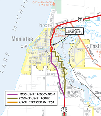 1955 (Nov 18) – The US-31 realignment project south of the Memorial (bascule) Bridge spanning the Manistee River in Manistee—begun in 1951 with the opening of the first phase—is completed with a rerouting/realignment of the highway through the remainder of the city. From First St, US-31 now continues southerly via Cypress Ave to 8th St where it bends southeasterly via a new highway alignment along present-day Manistee Hwy before merging back into the existing route along Grant Hwy near the present-day intersection with Stronach Rd. The former stair-stepping route of US-31 running easterly from Cypress St via First St, southerly along Sibben St, easterly on Fifth St, southerly via Kosciusko St, easterly along Eighth St, southerly on Vine St, easterly via 13th St, then southerly along Main St and exiting the city along Nelson St southerly to Stronach Rd was not an officially-established trunkline route, rather it had been a "marked-and-maintained" route since 1930 and state maintenance now ceases and local maintenance resumes. What is cancelled, however, is the officially-established route of US-31 from 1930 which was never constructed or signed as such. From Grant Hwy & Preuss Rd cutting "cross country to the cnr of Maple Rd & Red Apple Rd, then northerly along Maple Rd/Maple St, then easterly via First St to DIvision St, this official trunkline route is cancelled without ever actually being signed as part of US-31. —Thanks to John McDowell for the heads-up! 1955 (Nov 18) – The US-31 realignment project south of the Memorial (bascule) Bridge spanning the Manistee River in Manistee—begun in 1951 with the opening of the first phase—is completed with a rerouting/realignment of the highway through the remainder of the city. From First St, US-31 now continues southerly via Cypress Ave to 8th St where it bends southeasterly via a new highway alignment along present-day Manistee Hwy before merging back into the existing route along Grant Hwy near the present-day intersection with Stronach Rd. The former stair-stepping route of US-31 running easterly from Cypress St via First St, southerly along Sibben St, easterly on Fifth St, southerly via Kosciusko St, easterly along Eighth St, southerly on Vine St, easterly via 13th St, then southerly along Main St and exiting the city along Nelson St southerly to Stronach Rd was not an officially-established trunkline route, rather it had been a "marked-and-maintained" route since 1930 and state maintenance now ceases and local maintenance resumes. What is cancelled, however, is the officially-established route of US-31 from 1930 which was never constructed or signed as such. From Grant Hwy & Preuss Rd cutting "cross country to the cnr of Maple Rd & Red Apple Rd, then northerly along Maple Rd/Maple St, then easterly via First St to DIvision St, this official trunkline route is cancelled without ever actually being signed as part of US-31. —Thanks to John McDowell for the heads-up! |
| |
1955 (Dec 3) – A new easterly bypass of Hart is completed and opened to traffic from Russell St–Polk Rd on the southern city limit northerly to N State St north of the city. The former route of US-31 through Hart via Russell St and State St temporarily becomes an unsigned state trunkline highway route. |
| |
1956 (Mar 26) – The route of US-31 in western Charlevoix Co is completely reconstructed from the west Charlevoix city limit southwesterly toward Norwood. While much of the 1956 alignment lies directly atop the previous route, a few minor relocations result in abandonments and obliterations of the old route. The one major relocation and cancellation occurs just southwest of the Charlevoix Municipal Airport where the road known today as "Old US-31 S" is bypassed by the present route of US-31 and turned back to local control. |
| |
1956 (Mar 26) – The officially-established shoreline routing of US-31 in Ottawa Co from Grand Haven southerly to the Lake Macatawa outlet, unconstructed since its establishment in 1935, is officially removed from the books and cancelled as a potential trunkline routing. |
| |
1956 (Sept 29) – The Michigan State Highway Dept announces that plans for an easterly bypass of Niles primarily following the Seventeenth St corridor through the eastern portion of the city which has been a point of contetion with local officials and Niles residents. State Highway Commissioner Charles Ziegler has been a strong proponent of the near-eastside bypass of Holland even in the face of intense opposition, which champion a bypass route to the west of the city. The Seventeenth St bypass route was a key component in relocating US-31 to follow a much-upgraded M-140 corridor northerly from the city through Watervliet before rejoining its existing route at South Haven. (Existing US-31 from Niles through Berrien Springs, St. Joseph and the Hagar Shore area to South Haven was to have been designated as US-33 under this plan.) |
| |
1957 – Various changes to the route of US-31 during this year:
- (June 17) – A new, more direct highway alignment is completed and opens to traffic from the center of Grand Haven Twp northerly via its present-day alignment and Beacon Blvd to Jackson St in the middle of the city of Grand Haven. The former route of US-31 from Ferris St northerly along 168th and Beechtree Sts, westerly via Fulton St and northerly again via 7th St to Jackson St is turned back to local control.
- (June 24) – The 3.8 miles of the northern portion of the US-31 Muskegon bypass—the portion of Harvey St from Laketon Ave northerly to Brusse St and Access Highway from Harvey St westerly to BUS US-31/Ottawa St—is finally established as a state trunkline highway route, almost 6½ years after it first opened to traffic as a portion of the mainline of US-31! (Until now, this segment has been a marked-and-maintained segment.)
- (June 24) – The remaining portion of the former route of US-31/M-37 along McCrae Hill Rd southwest of Traverse City, from Silver Pines Rd northerly to US-31/M-37, is turned back to local control. The rest of this former route of US-31/M-37 had been transferred in 1949 and its is unclear at present why this portion was retained for eight additional years.
- (Oct 21) – One week prior to the opening of the new Mackinac Straits Bridge between Mackinaw City and Saint Ignace, the freeway approach highway is officially established as a state trunkline route from US-31/Nicolet Ave northerly to the foot of the new bridge. It is unclear whether the freeway opens to traffic as far as the Jamet St interchange for this next week or if traffic is only allowed on as of the bridge's opening on November 1st, however it can be assumed US-31 remains posted on its existing route to the State Highway Ferry Docks until that time when it is transferred to the freeway approach on the 1st, terminating with US-23 at the southern end of the bridge. Officially, though, the former route of US-31 along Nicolet Ave, the "Old 31" cut-across and along Huron st from the US-23/US-27 jct northerly to the ferry docks is transferred to local control on this date.
- (Nov 25) – The new easterly bypass of Hart opened to traffic in December 1955 is (finally!) officially established as a state trunkline route. The former route of US-31 through Hart via Russell St and State St, which had been an unsigned state trunkline route for the past 23 months, is turned back to local control.
|
| |
1958 (Sept 9) – In a northerly continuation of the 1954 "Elk Rapids bypass," US-31 is relocated onto a new controlled-access alignment for approximately 7 miles beginning at Dexter St-Ames St in Elk Rapids northerly, merging back into the former route at Cairn Hwy north of Kewadin. The highway is a two-lane facility built on four-lane right-of-way, though the proposed northbound lanes would never be constructed. The former route along Ames St and Cairn Hwy from Elk Rapids through Kewadin is turned back to local control. |
| |
1958 (Oct 22) – The first portion of US-31 freeway is completed and opened to traffic from the Grand River in Ferrysburg to just north of the US-16 & BUS US-31 jct southeast of Muskegon. The freeway is built parallel to Old US-31/Grand Haven Rd within a mile to the east, curving to the east north of Sternberg Rd and merging into the 1950 Harvey St bypass at Airport Rd just north of Airline Rd. The six-mile, $2.5-million project is officially opened to traffic at a special dedication ceremony. The former route of US-31 between Ferrysburg and Muskegon Heights remains an unsigned state trunkline highway for the time being. |
| |
1959 (June 12) – A new six-lane bascule (draw) bridge is completed spanning the Grand River between Grand Haven and Ferrysburg, replacing the 1924 swing bridge. The new structure consists of nine spans, is 750 feet long, and clears the river channel by about 25 feet. The 1924 bridge, sitting immediately upstream from the new bridge, is removed in 1960. |
| |
1959 (July 24, Oct 22) – The portion of the US-31 freeway in Ottawa Co opened to traffic the previous October is established as a state trunkline route on July 24 (with the former route along 174th Ave transferred to local control) while the portion in Muskegon Co is established on October 22 (again, with the former route via Grand Haven Rd turned back to local control). It is unclear why it takes almost a year to officially assume the route into the state highway system, however. |
| |
1959 (Oct 1–Nov 25) – A 2½ mile section of [Future] US-27 freeway is completed from the southern end of the US-31 Mackinac Bridge approach freeway (at present-day I-75 Exit 337) southerly to Potter Rd south of Mackinaw City on October 1. Included in the $1.18 milion project is an overpass at existing US-31 (Mackinaw Hwy) and southbound on- and northbound off-ramps along with a partial interchange at present-day Exit 336 leading toward the proposed US-31 relocation heading southwesterly toward Carp Lake. Traffic starts flowing on the new freeway—referred to as the "US-27 expressway," although it was likely not signed as such since it does not connect back to the existing US-27 at Indian River yet—as far south as the new US-31 off-ramps (present-day Exit 336). The new freeway segment is likely signed as part of US-31, though, as it runs parallel to and replaces the existing segment of US-31 in the area. That former 2.0-mile segment of US-31 along Mackinaw Hwy bypassed by the new freeway segment between the Nicolet St interchange and present-day Exit 336 is cancelled as a state trunkline route on November 25 and turned back to county control. |
| |
1959 (Oct 15) – Built by the State Highway Dept as part of the new US-31 Grand Haven bascule bridge project, which opened to traffic four months prior, the service road under the new span is transferred to city control and is now known as Harbor Island Dr. |
| |
1959 (Oct 22) – In a major trunkline realignment project, a brand-new limited-access expressway route into downtown Muskegon from the southeast side is completed. The new Seaway Drive route, initially known as the "Norton–Glade Expressway," named for two of the existing streets the highway runs parallel to, is given the US-16/BUS US-31 designation and bypasses Muskegon Heights en route into downtown Muskegon where the route splits into two, parallel one-way streets, Muskegon Ave (nbd) and Webster Ave (sbd), to M-46/First St. The former BUS US-31 route along Merriam and Peck Sts is returned to local control. |
| |
1960 – The 1950 "Harvey Street bypass" route along the east side of the City of Muskegon is converted from a two-lane surface route to a fully-controlled access freeway from the northern end of the completed freeway (1959) near Airport Rd southeast of the city northerly either atop (Airport-Laketon) or immediately adjacent to (Laketon-Lawrence) the Harvey St route to Lawrence Ave approximately ¼ mile north of the M-46/Apple Ave interchange, where it temporarily merges back down into the two-lane Harvey St alignment. (The portion of this route from Laketon Ave northerly to Lawrence Ave is established as a trunkline and the former route via Harvey St is turned back to local control on October 12, 1961, however sources indicate it was likely complete and open to traffic in 1960.) The 3.1 miles of new US-31 freeway from the US-16 jct northerly to Laketon Ave consists of a new 24-foot-wide set of northbound lanes constructed immediately east of the existing Harvey St route of US-31, which is converted into the southbound lanes of the freeway bypass, while the 1.4 miles from Laketon Ave to 2,100 feet north of M-46/Apple Ave consists of two new 24-foot-wide sets of parallel roadways constructed immediately to the west of the existing Harvey St. |
| |
1960 (Aug 19) – A sweeping curve is added to the route of US-31 in northernmost Mason Co to replace two sharp 90° turns in the highway. The former route via Hoague and LaSalle Rds is turned back to local control on this date. —Thanks to John McDowell for the heads-up! |
| |
1960 (Aug 31) – The official route for the segment of I-96/US-31 freeway (present-day I-196/US-31) in Berrien, Van Buren and Allegan Cos from I-94/US-12 northeast of Benton Harbor to the south side of Holland is announced by the State Highway Dept. Construction on this segment is scheduled to begin in 1961. |
| |
1960 (Nov) – The State Highway Dept announces the northerly extension of the US-33 route designation concurrently with US-31 northerly from St Joseph for approximately 10 miles to a new northern terminus (for US-33) at Hagar Shore Rd northwest of Coloma, while US-31 continues northerly along its existing route toward South Haven. This is done, according to State Highway Dept officials, in preparation for the rerouting
of US-31 along the new I-96 (present-day I-196) freeway
under construction from I-94 northerly. |
| |
1961 (Sept 25) – The "downtown Petoskey bypass" route for US-31, also known as Sunset Dr, is officially established as a state trunkline and likely opens at this time as well. The new two-lane bypass takes traffic out of Petoskey's downtown core and removes three 90-degree turns from the route as well. The former route along Mitchell St from Elizabeth St easterly to Howard St, northerly via Howard to Bay St, easterly on Bay to Lewis St and northerly via Lewis back to Sunset Dr is turned back to local control. |
| |
1961 (Sept 30) – The I-96/US-31 freeway (present-day I-196/US-31) from I-94/US-12 northeast of Benton Harbor northerly to the Van Buren/Allegan Co line at South Haven is established as part of the state trunkline highway system. The only portion completed and opened to traffic at this time, however, is the first 7-mile segment from I-94/US-12 to US-31/US-33/Hagar Shore Rd near the Berrien/Van Buren Co line. |
| |
1961 (Oct 21) – As the existing US-31 Harvey St "Muskegon East Belt" bypass is being upgraded to full freeway standards, the 1.45-mile segment from Laketon Ave northerly to Mancoux Ave north of M-46/Apple Ave is cancelled as a state trunkline and turned back to local control. Simultaneously, the 1.32-mile segment of the parallel US-31 freeway from Laketon northerly to Lawrence Ave (where the freeway temporarily terminates and merges back into Harvey St) is officially established as a state trunkline highway. |
| |
1962 (Dec 10–12) – With the decommissioning of US-16 in Michigan, the routing of US-16/BUS US-31 into downtown Muskegon is redesignated as BS I-196/BUS US-31. |
| |
1962 (Late Aug, Sept 29, Nov 15) – A realignment and two related official establishments for a US-31 "cut-off" in the Carp Lake area in northeastern Emmet Co:
- (Late August) – In Late August, the new, two-lane, limited-access realignment of US-31 from Carp Lake northeasterly to Mackinac Hwy (existing US-31) at the new I-75 interchange south of Mackinaw City is completed and opened to traffic, The new alignment, in addition to being limited-access (no private driveway acess), is more direct, shaving 1.185 miles from the route of US-31 and removes a sharp, 90° curve from the route as well.
- (Sept 29) – The new, 4.115-mile long limited-access alignment of US-31 between Carp Lake and Mackinaw Hwy is officially established as a state trunkline route, even though it has been opened to traffic for a month. Simultaneously, the 5.3-mile long former route of US-31 along Paradise Trail and Mackinaw Hwy is cancelled as a trunkline highway and turned back to county control on this date.
- (Nov 15) – A month-and-a-half later, the short segment of US-31 between Mackinaw Hwy and the I-75 interchange is also established as a state trunkline highway route (at the same time all of I-75 in Cheboygan Co is similiarly established), but this is just an official transfer, as I-75 and the US-31 interchange have both been complete at this location for two years.
|
| |
1963 (Aug 30, 11 am–Noon) – A 22½-mile long segment of I-96/US-31 freeway opens from I-94 northeast of Benton Harbor (present-day Exit 34) northerly through western Van Buren Co, bypassing South Haven to the east, and terminating at North Shore Dr (present-day Exit 22), ½ mile north of the Van Buren/Allegan Co line. At the northern terminus of the completed freeway, the US-31 designation temporarily heads westerly via North Shore Dr back to its existing alignment along Blue Star Hwy. The first ribbon-cutting ceremony takes place at the I-94 interchange for the northbound lanes, while a second ceremony at South Haven one hour later opens the southbound lanes of I-96/US-31. Construction on the next segment of the freeway from South Haven to Douglas is nearing completion. The US-31 designation is routed northerly from Scottdale via the ex-M-139 to I-94, then northeasterly with I-94 to the new freeway and then northerly to the end of the freeway at Hagar Shores Rd (at present-day Exit 7). The former route of US-31 through St Joseph between Scottdale and Hagar Shore Rd becomes solely US-33. |
| |
1963 (Sept 30) – 21.92 miles of the 22½-mile long segment of I-96/US-31 freeway opened to traffic one month earlier are officially established as a state trunkline route from the southern terminus of I-96 at I-94 northeast of Benton Harbor to the Van Buren/Allegan Co line northeast of South Haven. The final ½-mile of this newly-opened segment is not yet officially established as a trunkline route, nor is the connector along North Shore Dr between the new freeway and existing US-31 along Blue Star Hwy. The 12.48-mile portion of the former route of US-31 along Blue Star Hwy from Hagar Shore Rd in northern Berrien Co northerly to M-140 south of South Haven in Van Buren Co is turned back to county control at this time. The portion of the former US-31 route along the South Haven Bypass between M-140 and North Shore Dr, constructed 1942–43, is retained as a state tunkline route and earmarked to be designated as BL I-96, however it likely the State Highway Dept held off on erecting BL I-96 route markers as a major route designation change was in the planning which would directly affect South Haven's new Interstate Business Connection. |
| |
1963 (Sept 30) – Also established on this date in Manistee Co are two slight realignments to the route of US-31: from northeast of Milarch Rd northeasterly to Lyman Rd in the Norwalk area and in the immediate vicinity of the 9 Mile Rd Linderman Rd intersection. The two segments of the former route of US-31 are both turned back to local control. |
| |
1963 (Oct 21) – Approval by the American Association of State Highway Officials (AASHO) is given to flip-flop the I-96 and I-196 route designations west of Grand Rapids. Planning for the switchover will take the next couple months, however, and I-96 remains posted with US-31 along the completed portion of the "Benton Harbor–Holland Freeway" between I-94 and South Haven. The planned BL I-96 routing at South Haven will now be designated BL I-196 and the concurrent BS I-196/BUS US-31 leading into Muskegon will become BS I-96/BUS US-31 once the transition is completed. |
| |
1963 (Dec 16) – Even though official approval to swap the I-96 and I-196 route designations west of Grand Rapids was received nearly two months prior, two segments of the so-called "Benton Harbor–Holland Expressway" are opened to traffic in Allegan Co—bearing the I-96/US-31 designation, albeit temporarily. The segments include a northerly extension of the completed I-96/US-31 freeway from North Shore Dr (present-day Exit 22) north of South Haven northerly past Glenn and Ganges to existing US-31 south of Douglas (at present-day Exit 36). The "Saugatuck–Douglas Bypass" and its span across the Kalamazoo River is not yet complete, so traffic is forced off the new freeway back onto the existing US-31 route (along present-day A-2/Blue Star Hwy) through Douglas and past Saugatuck. Northeast of Saugatuck, the second new segment of I-96/US-31 freeway begins (at present-day Exit 41) and continues northerly to a tie-in with the southern end of the existing US-31 Holland Bypass (at present-day Exit 47) on the southern edge of Holland. These two new segments are opened to traffic with temporary route markers bearing the I-96 designation, as the State Highway Dept is still in the process of implenting the I-96/I-196 route swap.
On the same day it opens to traffic, the 14.654-mile South Haven-to-Douglas segment and the 6.609-mile Saugatuck-to-Holland Bypass segment are both officially established as state trunkline routes. Similarly, the two bypassed segments of the former US-31 along present-day A-2/Blue Star Hwy—the 14.312-mile portion from North Shore Dr to present-day Exit 36 south of Douglas and the 6.962-mile portion from present-day Exit 41 north of Saguatuck to the south end of the existing Holland Bypass (present-day Exit 47) are cancelled as a state trunkline route and turned back to local control. |
| |
   1964 (Jan 6–10) – While the I-96 and I-196 designation swap was approved the previous October, the actual swap-out of the route markers on both routes occurs during the first week of January 1964. All I-96 route markers along the completed portions of the so-called I-96/US-31 Benton Harbor–Holland Expressway are swapped out for I-196 route markers, while the I-196 signs posted along the US-16 freeway between Holland and the east side of Grand Rapids are replaced by I-96 markers. 1964 (Jan 6–10) – While the I-96 and I-196 designation swap was approved the previous October, the actual swap-out of the route markers on both routes occurs during the first week of January 1964. All I-96 route markers along the completed portions of the so-called I-96/US-31 Benton Harbor–Holland Expressway are swapped out for I-196 route markers, while the I-196 signs posted along the US-16 freeway between Holland and the east side of Grand Rapids are replaced by I-96 markers. |
| |
1964 (June 30) – A major portion of the northerly extension of the US-31 freeway at Muskegon is opened to traffic beginning at Lawrence Ave (north of M-46/Apple Ave) continuing across the the Muskegon River and north to Colby Rd at Whitehall, where US-31 temporarily transitions back to its existing route through Whitehall and Montague. The new freeway north of Colby Rd to its ending north of Fruitvale Rd north of Montague is still under construction and will open later in the year. Additionally, upon openng, only the new freeway's northbound lanes are complete and open to traffic between Lawrence Ave at Muskegon and M-20/Holton Rd (present-day M-120) northeast of North Muskegon, while southbound US-31 traffic is forced to exit the new freeway at M-20, travel southwesterly via M-20 into North Muskegon, then use the Veterans Memorial Causeway into Muskegon before reaccessing the existing Muskegon "East Belt" freeway via the Access Highway Route. The southbound lanes will open to traffic later in the year. While the freeway is open only to Colby Rd at Whitehall, the entire freeway from Lawrence Ave at Muskegon to north to north of Fruitvale Rd north of Montague is established as a state trunkline route. Simultaneously, the segment of former US-31 along Whitehall Rd from M-20/Holton Rd (present-day M-120) at North Muskegon and Colby Rd at Whitehall is transferred to local control, while the 0.341-mile segment of Colby Rd between Whitehall Rd and the new freeway as well as the 0.482-mile portion of Fruitvale Rd between the former US-31 (present-day Old US-31) and the new freeway are both transferred to state control as part of the future BUS US-31 routing at Whitehall–Montague (once the remainder of the freeway opens later in the year). Opening this segment of the $10 million freeway start with a ribbon-cutting at 10:00 am followed by an auto tour of the route by dignitaries and those in attendance, with the highway itself open to traffic by Noon. |
| |
1964 (July 31) – The I-196/US-31 Douglas/Saugatuck bypass is established as a state trunkline highway route and simultaneously opened to traffic from existing US-31 at Exit 36 to existing US-31 at Exit 41. The twin spans over the Kalamazoo River are the final pieces remaining before the segment could be opened. This is the first segment of I-196 to be completed and opened to traffic along its new Benton Harbor–Grand Rapids alignment. The former route of US-31 along present-day A-2/Blue Star Hwy is cancelled as a trunkline route and turned back to local control. |
| |
1964 (Sept) – The southbound lanes of the new US-31 freeway northeast of Muskegon—specifically from the M-20/Holton Rd (present-day M-120) interchange southerly across the Muskegon River flats to the tri-level north BUS US-31 interchange—are completed and opened to traffic a few months after the remainder of the freeway is opened to traffic on June 30. Southbound traffic had been routed off the US-31 freeway onto M-20 into North Muskegon, then southerly across the Veterans Memorial Causeway (also signed as part of M-20 since 1961) and the back to the new freeway along the Access Highway corridor during the previous few months. |
| |
1964 (Oct 30) – The "Whitehall–Montague Bypass" portion of the new US-31 freeway in northern Muskegon Co is completed and opened to traffic. This is the last segment of the $10 million northerly extension of the US-31 freeway from the Muskegon area to just shy of the Oceana Co line. This portion of the freeway runs from Colby Rd on the east side of Whitehall and northwesterly across the White River, turning northerly through an interchange at Fruitvale Rd where the new freeway narrows down to two lanes immediately north of the Fruitvale Rd interchange north of Montague and merges back into the existing highway near Meinert Park Rd. The former route through Whitehall and Montague via Colby Rd/St, Thompson St, Dowling St, Water St and Fruitvale Rd is now officially signed as the Whitehall–Montague BUS US-31 routing. The former route of US-31 between Fruitvale Rd and the northern end of the new US-31 freeway near Meinert Park Rd (present-day Old US-31) is retained as an unsigned state trunkline highway segment.
At this same time, the northside connector portion of Muskegon's BUS US-31 route between the tri-level interchange northeast of the city and the jct of BUS US-31 & M-20 at the southern end of the Veterans Memorial Causeway north of downtown is completed and opened to traffic. The temporary route of BUS US-31 via M-20 north across Veterans Memorial Causeway into North Muskegon then northeasterly to US-31 is removed and transferred to its new permanent route. |
| |
1965 (Jan 20) – The segment of Muskegon's BUS US-31/Skyline (Seaway) Dr expressway from Bayou Dr through the M-20/Veterans Memorial Causeway junction then easterly to the tri-level US-31 interchange northeast of Muskegon that opened to traffic nearly three months previously is officially established as a state trunkline highway. Simultaneously, the former route of BUS US-31 along Ottawa St from Bayout St northeasterly to the Veterans Memorial Causeway intersection is turned back to city control, as are the segments of 1.) Access Hwy from the dead-end west of Getty St (the portion west of the dead-end is either subsumed under the new BUS US-31 route or obliterated as a public roadway) easterly to the point where it meets the US-31 freeway and 2.) the segment of Harvey St immediately across the US-31 freeway from Access Hwy (about 1,000 south of Stebbins Rd) southerly to a point directly across the freeway from Marcoux Ave. |
| |
1965 (June 9-25) – The final link in the route of Muskegon's BUS US-31 route of Seaway Dr/Skyline Dr is finally completed and opened to traffic on June 9 on the northeast end of downtown Muskegon. These changes are reflected in official establishments and cacellations 16 days later on June 25 when the 1.274-mile segment of BUS US-31 along Muskegon & Webster Aves from First St northeasterly to Spring St and then north-northeasterly along Skyline/Seaway Dr from Spring St to Bayou St is officially established as a state trunkline highway route. At the same time, the 1.038 mile of Ottawa Ave from Bayou St south-southwesterly to Cedar St, then southwesterly along Clay Ave to Terrace St, as well as the two blocks of Terrace St beween Clay St and Muskegon Ave are all cancelled as part of the trunkline route and turned back to city control. The temporarily marked-and-maintained segment which carried southbound BUS US-31 and westbound M-20 traffic along Eastern Ave from Ottawa St to Western Ave and then via Western from Eastern to Terrace St and Terrace St for the one block back to Clay Ave is no longer a marked trukline route for southbound BUS US-31 and westbound M-20 and state maintenance ceases. |
| |
1966 (July 1) – Two realignments to the route of US-31 in northeastern Grand Traverse Co are officially established on this date. The first realignment at Yuba straightens the route of the highway with the former route being either abandoned or obliterated. The second relocation removes two sharper turns in the highway beginning at Bates Rd and continuing southwesterly, with the former US-31 from Bates Rd southwesterly being abandoned as a public road and the portion along Bates Rd itself being turned back to local control. |
| |
1967 (June 16) – A minor realignment in the Village of Honor in Benzie Co shaves a few hundredths of a mile from the route of US-31, with the former route being turned back to local control. |
| |
1969, 1971 – The former US-31 (Blue Star Hwy) between South Haven and Holland is designated as A-2 in 1969, one of two original Intercounty Highways. A-2 is extended in 1971 southerly along Blue Star Hwy to end at US-33 in Berrien County. |
| |
1972 – The former US-31/Blue Star Hwy alignment around South Haven, designated as BL I-196 in 1963, is redesignated as a portion of A-2, although it remains a state trunkline into the 1980s. (This, ironically, was the original bypass of South Haven from the mid-1940s, which itself was bypassed twenty years later.) The route of BL I-196 is then transferred to the downtown route through South Haven on its present-day alignment. |
| |
1972 (Dec 15) – A minor realignment just west of Petoskey in Emmet Co shaves a few hundredths of a mile from the route of US-31 between Black Bird Rd and Resort Pike, with the former route being relinquished and obliterated. |
| |
1973 – The new I-196 freeway is completed between exisiting I-196/US-31 southwest of Holland and Grand Rapids. At this time, a new BL I-196 designation is routed along US-31 northerly toward Holland, then northerly on BUS US-31 into and through downtown, and finally easterly along the former M-21 past Zeeland back to I-196. |
| |
1975 – Two new freeway developments in Oceana and northern Muskegon Counties:
- (Apr 16) – An 18.09-mile long northerly extension of the US-31 freeway from just north of the Fruitvale Rd interchange north of Montague northerly to Polk Rd west of Hart is officially established as a state trunkline highway routing. The freeway is not yet complete at this time, however, and would be opened in two stages, the first of which would come later in the year. Also established on this date is Polk Rd itself from the new US-31 freeway interchange easterly to State St and State northerly from Polk to Lincoln St, ostensibly for a new BUS US-31 route once the freeway is completed and is likely not signed in the field at this time.
- (June 17) – At its regular meeting in White Sulphur Springs, WV, the U.S. Route Numbering Subcommittee of the American Association of State Highway & Transportation Officials (AASHTO) approves a request from the Michigan Dept of State Highways & Transportation to relocate the route of US-31 from south of New Era to north of New Era and placing it onto a new freeway facility from the current freeway's northern terminus to M-20, then easterly along M-20 back to the existing route. This action comes just over six months prior to that freeway segment being completed and opened to traffic.
- (Dec 23) – The first stage of the US-31 freeway extension into Oceana Co opens from the northern end of the completed freeway three miles north of Montague to the new M-20 extension at Stoney Lake Rd near New Era, where US-31 temporarily turns easterly via the M-20 extension back to its former alignment. The former US-31 routing via Whitehall Rd in Muskegon Co (north of B-15/B-23/Fruitvale Rd) and OLD US-31/Oceana Dr in Oceana Co becomes an unsigned state trunkline.
|
| |
1976 – Three more freeway developments in Oceana Co:
- (July 13) – At its regular meeting in Hot Springs, Virginia, the U.S. Route Numbering Subcommittee of the American Association of State Highway & Transportation Officials (AASHTO) approves a request from the Michigan Dept of State Highways & Transportation to relocate the route of US-31 from New Era to Hart and placing it onto a new freeway facility from the current freeway's northern terminus at M-20 northerly to a "temporary connection to the present US-31 in Hart." This action comes just five months and a day prior to that freeway segment being opened to traffic.
- (Dec 14) – Another new portion of US-31 freeway is completed and opened to traffic from M-20 at New Era northerly 9.2 miles to Polk Rd west of Hart. There, US-31 traffic is routed easterly via Polk Rd to the existing US-31. OLD US-31/Oceana Dr from M-20 northerly through Shelby to Polk Rd at Hart becomes an extension of the unsigned state trunkline.
- (Dec 14) – On the same day as the M-20-to-Hart segment of the US-31 freeway is opened to traffic and with constrution to the north yet to begin in earnest, a 5.66-mile long extension of the US-31 freeway in Oceana Co from Polk Rd at Hart northerly to just north of the BUS US-31/Monroe Rd interchange southeast of Pentwater is officially established as a state trunkline. This portion of the freeway will not open for nearly two years.
|
| |
1977 (Mar 23) – The 0.37 mile portion of Polk Rd at Hart from State St easterly to Oceana Dr is "temporarily" transferred to state control on this date, primarily because Polk Rd is now operating as the temporary connector between the northern end of the new US-31 freeway west of Hart and the existing highway along Oceana Dr southeast of downtown. (As of 2023, this "temporary" connector is still an unsigned state trunkline.) |
| |
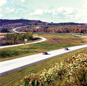 1977 – A nine-mile stretch of US-31 Freeway in the wooded hills of Oceana Co is named most beautiful highway in the country in a forest environment in a national competition sponsored by the Federal Highway Administration. (See image at right.) 1977 – A nine-mile stretch of US-31 Freeway in the wooded hills of Oceana Co is named most beautiful highway in the country in a forest environment in a national competition sponsored by the Federal Highway Administration. (See image at right.) |
| |
1978 (June 29) – At its regular meeting in Coeur d'Alene, Idaho, the U.S. Route Numbering Subcommittee of the American Association of State Highway & Transportation Officials (AASHTO) approves a request from the Michigan Dept of State Highways & Transportation to relocate the route of US-31 from Hart to southeast of Pentwater and placing it onto a new freeway facility from the current freeway's northern terminus northerly to BUS US-31. The freeway segment opens to traffic in exactly three months. |
| |
1978 (Sept 29) – The US-31 freeway is extended northerly 5½ miles from Polk Rd at Hart to the southern leg of BUS US-31 (at the Monroe Rd interchange) southeast of Pentwater and US-31 is temporarily directed easterly via Monroe Rd (formerly part of BUS US-31) back to its previous route at Oceana Dr. OLD US-31/Oceana Dr from Polk Rd at Hart northerly to Monroe Rd becomes yet another extension of the unsigned "OLD US-31" state trunkline, as does Polk Rd from the US-31 freeway easterly to Oceana Dr/OLD US-31. |
| |
1978 (Oct 28) – At its regular meeting in Louisville, Kentucky, the U.S. Route Numbering Subcommittee of the American Association of State Highway & Transportation Officials (AASHTO) approves a request from the Michigan Dept of State Highways & Transportation and the Indiana State Highway Commission to relocate the route of US-31 from South Bend, Indiana to Niles, Michigan placing it onto a new freeway facility being constructed. This segment of US-31 freeway will open to traffic in less than a year. |
| |
1979 (June 8) – State officials announce construction is planned to begin on a new US-31 tourist information center (welcome center) just north of the Indiana state line near Niles along the nearly-completed segment of freeway. It is to be the first public facility in the state to be powered primarily by solar and wind-generated electricity with hopes that it may prove to be technically and economically feasible for other similar facilities. The proposed center, estimated to cost $790,000 with the federal government paying for about 75%, is scheduled to be open to the public by summer 1980. (Spoiler: While the ramps and parking lots as well as general site grading were eventually completed, the welcome center in question remains unbuilt to this day.) |
| |
1979 (Aug 10, 3pm) – A 3.3-mile portion of the new US-31 freeway extending northerly from Indiana near South Bend to US-12/Pulaski Hwy just southwest of Niles is completed and opened to traffic. Opening ceremonies for the new segment of freeway are held by both states at the state line and attended by Indiana Governor Otis Bowen and Ms. Michigan Transpo Linda Perkins. From the northern end of the new freeway, US-31 is routed easterly via US-12 for approximately one mile, then northeasterly via BUS US-12 (Chicago Rd, Lincoln St/Grant-St Joseph Sts & W Main St) into downtown Niles, where it meets up with its former route and the co-signed US-33. The former US-31/US-33 between South Bend, Indiana and Niles becomes solely US-33. —Thanks to Marc Fannin for clarification on this routing! |
| |
1980 (Apr 3) – The one-mile segment of unsigned OLD US-31 along Michigan Ave in Rothbury in Oceana Co is cancelled as a state trunkline route and turned back to village control. The freeway bypass of the village had opened 4½ years prior. |
| |
1980 (Jan 24) – The 3.302-mile segment of US-31 freeway opened to traffic the previous August is officially established as a state trunkline route between the Indiana state line and US-12 southwest of Niles. |
| |
1980 (Oct 16–21, Nov 6) – The US-31 continues its northerly push toward Ludington. On October 16 the 3.8-mile stretch of US-31 freeway from its existing end at BUS US-31/Monroe Rd southeast of Pentwater (present-day Exit 154) northerly to the jct of exisitng US-31 and BUS US-31 at Washington Rd on the Oceana/Mason Co line is officially established as a state trunkline route. Five days later, an 11.423-mile northerly extension of the new freeway route in Mason Co is established from the Oceana/Mason Co line northerly to US-10 east of Ludington on October 21. Then on November 6, the portion of the freeway in Oceana Co established on the 16th is completed and opened to traffic. At the north end of the newly-opened segment, the new freeway narrows back down and merges into the existing US-31 alighment right at Washington Rd on the county line with the existing US-31 & BUS US-31 jct there handling traffic heading to or coming from Pentwater while a new interchange is completed. (The new BUS US-31 interchange with a grade separation for former US-31—renamed Oceana Dr—and nbd off- and sbd on-ramps will be complete in 1981.) |
| |
1981 (June 25) – At its regular meeting in Dallas, the U.S. Route Numbering Subcommittee of the American Association of State Highway & Transportation Officials (AASHTO) approves a request from MDOT to relocate the route of US-31 from BUS US-31 southwest of Pentwater to BUS US-31 northeast of Pentwater, placing it onto the new freeway facility which opened to traffic 7½ months earlier. |
| |
1982–1985 – While construction on the second phase of the US-31 freeway in Berrien Co began soon after the first phase from the Indiana state line to US-12 southwest of Niles opened to traffic in 1979, work is halted between 1982 and 1985 due to a lack of funding and political wrangling over the route the new highway will take further to the north. Finally, in 1985, construction re-starts and work on the twin spans across the St Joseph River begins. |
| |
1984 – The entire routing of BS I-96 in Muskegon/Muskegon Heights is removed and BUS US-31 becomes the sole routing along Seaway Dr. |
| |
1986 (June 9) – At its regular meeting in State College, Pennsylvania, the U.S. Route Numbering Subcommittee of the American Association of State Highway & Transportation Officials (AASHTO) approves a request from MDOT to relocate the route of US-31 at Niles, placing it onto the new freeway facility which is scheduled to open to traffic in the next year. The relocation runs from the northern end of the existing freeway at US-12 northerly to Walton Rd, then northeasterly via a temporary connection along Walton Rd back to existing US-31 north of Niles. |
| |
1986 (Aug 25) – US-31's companion route through much of Berrien Co, US-33, is drastically scaled back from north of Coloma to end at jct US-31 & BUS US-12 in downtown Niles. The former US-31/US-33 between Niles and Scottdale becomes solely US-31 and all of the ex-US-33 between Scottdale and I-196/US-31 at Exit 7 north of Coloma is redesignated as M-63. While the changeover from US-33 is made official on this date, the route markers themselves are likely removed or swapped out soon after. |
| |
1986 (Sept 10) – The bridge carrying southbound US-31 over the Pentwater River in Oceana Co between Pentwater and Hart is washed out during a heavy rain storm which flooded the area. With the southbound lanes of the US-31 freeway closed, traffic is detoured easterly on Monroe Rd (formerly BUS US-31), then southerly via Oceana Dr (formerly US-31) into Hart, then westerly along Polk Rd (most of which is part of Hart's BUS US-31 routing) to rejoin the freeway at Hart. |
| |
1987 (Aug 16, 11am) – The US-31 freeway bypass of Niles is opened to traffic northerly from US-12/Pulaski Hwy to Walton Rd northwest of Niles, where US-31 now turns northeasterly via Walton back to its existing route. The freeway is opened in the afternoon after an 11:00 am dedication ceremony held at the south end of the southbound bridge over the St Joseph River. This phase of the freeway cost $31 million. A new BUS US-31 routing at Niles is then created by cobbling together a variety of different routes: From the US-31 & US-12 interchange, the new BUS US-31 proceeds easterly via US-12 to US-33/Eleventh St, then northerly via Eleventh St replacing the US-33 routing into downtown Niles, then westerly via BUS US-12/Main St to Front St (the former route of US-31), then northerly via Front St and the former US-31 to Walton Rd, where it terminates. The former route of US-31 (not assumed into the new BUS US-31 routing) via BUS US-12 (Chicago Rd, Lincoln St/Grant-St Joseph Sts & W Main St) in Niles retains the BUS US-12 designation. —Thanks to Marc Fannin for clarification on this routing! |
| |
1987 (Oct 1) – The replacement Pentwater River bridge carrying the southbound lanes of the US-31 freeway in northwestern Oceana Co between Pentwater and Hart is completed and opened to traffic, more than a year after the original bridge is washed out. Traffic once again flows through the area on the US-31 freeway instead of using the temporary detour route. |
| |
1987 – Also sometime in 1987, a new "spur" business routing debuts as BUS US-31 via Polk Rd and State St into downtown Hart. |
| |
1988 (June 7) – At its regular meeting at Grand Teton National Park, Wyoming, the U.S. Route Numbering Subcommittee of the American Association of State Highway & Transportation Officials (AASHTO) approves a request from MDOT to relocate the route of US-31 in Mason Co, placing it onto the new freeway facility currently under construction. The relocation runs from the northern end of the existing freeway at BUS US-31 on the Oceana/Mason Co line northerly to US-10/US-31 east of Ludington. |
| |
Late 1980s – The Blue Creek Fen located in the path of the proposed US-31 freeway in northern Berrien Co between Benton Center and Millburg is discovered and identified as a "unique resource," primarily due to it being home to a variety of unique species, including the Mitchell's satyr butterfly (which will be added to the Federal Endangered Species Act in 1991). This discovery brings progress on the northernmost segment of the US-31/Saint Joseph Valley Pkwy freeway to a halt. Additional studies reveal other state threatened species, such as the prairie trillium, white lady slipper, goldenseal, and spotted turtle, as well as state species of special concern like the Eastern box turtle and carex savarrosa, are found in the Blue Creek Fen. |
| |
1989 (Sept 12, Sept 22) – The US-31 freeway is extended northerly from BUS US-31 at the Oceana/Mason Co line to the existing route southeast of Ludington, approximately three miles south of US-10. The northbound lanes of the new freeway open first on September 12, followed by the southbound lanes 20 days layer on September 22 at 2pm. The former route of US-31 via Pere Marquette Hwy from the Oceana/Mason Co line to the northern end of the new freeway segment becomes an extension of the unsigned "OLD US-31" state trunkline. |
| |
1989 (Oct 6) – The Standing Committee on U.S. Route Numbering of the American Association of State Highway & Transportation Officials (AASHTO) officially approves the "Relocation of U.S. Route 31" on this day at their scheduled meeting in Atlanta, Georgia. The text of the request reads: "Beginning at the intersection of present U.S. Route 31 and a new facility west of Niles, then northerly over the new facility to the intersection of present U.S. Route 31 east of Benton Harbor." It would seem this request is both to cover for the relocation of US-31 onto the newly-constructed freeway from US-12 to Walton Rd two years prior and for the northerly extensions toward I-94 to come in the future. |
| |
1990 (July 26, 2:42pm) – The second segment of the US-31 freeway in southern Mason Co is completed and opens to traffic from the end of the existing freeway at the Old US-31/Pere Marquette Hwy interchange southeast of Ludington to US-10/US-31 east of the city. The section of former US-31 via Pere Marquette Hwy between the US-31 freeway interchange and US-10 at Ludington is retained as an unsigned state trunkline as "OLD US-31," but would become BUS US-31 fifteen years later. |
| |
1991 (Dec) – A new 1.736-mile long, two-lane Scottville bypass is completed from US-10 west of Scottville in central Mason Co, northery and northeasterly around the around the west side of the city, merging back into the existing route of US-31 at Hansen Rd. US-10/US-31 west of downtown Scottville reverts to just being US-10, while the former route of US-31 from US-10 in downtown northerly to the new bypass remains an unsigned state trunkline route for the time being, however. |
| |
1992 (Jan 10) – The 1.736-mile Scottville Bypass (see above) opened in late 1991 is officially established as a state trunkline route from Hansen Rd southerly and southwesterly to US-10/US-31 west of Scottville. The 0.703 miles of the former US-31 from Hansen Rd southerly to the new turned-in approach for Old US-31/N Main St is officially cancelled by obliteration—a new alignment for US-31 is constructed immediately west of the former route for the first ½ mile south of Hansen Rd before it curves to the southwest. |
| |
1992 (Oct 23–Nov 20) – The 8.736-mile long relocation of US-31 in Berrien Co is partially opened to traffic on October 23 when the southbound lanes from existing US-31 northwest of Berrien Springs (present-day Exit 15) southerly around the city and across the St Joseph River, hooking into the existing freeway at Walton Rd (present-day Exit 7) northwest of Niles. The opening of the northbound lanes—originally scheduled to open by November 6—is delayed until November 20 due to "almost continual wet weather" since the opening of the southbound side. Although initially intended on being constructed as a controlled-access freeway, the Walton Rd–to–Berrien Springs segment is instead built as a limited-access expressway, with access at most of the intersecting crossroads (instead of at only interchanges with the remaining roads crossing via grade separations). This is due to budget constraints during the onging recession. Transportation officials still plan to add the interchanges and grade separations in the future to complete the segment as a full freeway when funding is made available. (Intersections are located at Walton, Matthew, Range Line, Lake Chapin and Snow Rds.) In any event, the former route of US-31 between Niles and Berrien Springs—a portion of what is known locally as "Bloody 31"—is now superseded by a much safer route. The portion of that former route from Berrien Springs southerly to Walton Rd is now an unsigned trunkline route internally designated by MDOT as OLD US-31 (and known locally as "Old 31"), while the temporary connector along Walton Rd between Old 31 and the new US-31 route becomes an extension of Niles' BUS US-31. |
| |
1993 (May 4) – An 8.9-mile long segment of future US-31 freeway in Berrien Co from existing US-31 northwest of Berrien Springs northerly to Napier Ave east of Benton Harbor is officially established as a state trunkline highway route. It would be a decade before this segment of freeway would be completed and opened to traffic. |
| |
1993 (June 30) – The 8.736-mile segment of US-31 completed and opened to traffic the previous fall is officially established as a state trunkline highway route from the Walton Rd intersection (present-day Exit 7) and existing US-31 northwest of Berrien Springs (present-day M-139 at Exit 15). |
| |
1995 (Dec 1, 10:00am) – The US-31 freeway (referred to by local area residents as the "US-31 Bypass") in Berrien Co as well as in St Joseph and Elkhart Cos in Indiana is officially dedicated as the "St Joseph Valley Parkway" at a dedication ceremony at the Berrien Springs 1839 Courthouse. Signs with the new name are reported to have been recently installed in both states. |
| |
1997 (Mar 20) – The 0.793-mile route of OLD US-31 at Scottville in Mason Co is transferred to local control, approximately five years after the westerly US-31 bypass of Scottville was completed and opened to traffic. The southernmost 0.294 mile of the segment, corresponding to N Main St from US-10/State St in downtown Scottville to the northern city limit, is turned back to city jurisdiction, while the 0.499 mile long northern portion of N Main St from the city limit northerly to US-31 is transferred to County control. |
| |
1995–97 – Conversion of the US-31 expressway in Berrien County to full freeway is all but completed (with the exception of the Matthew Rd intersection) with four new overpasses and two new interchanges constructed. Also, the concurrently designated portions of BUS US-31 (with US-12 and BUS US-12) between Exit 3 and downtown Niles is removed, making BUS US-31 at Niles a spur-route into downtown from the north. |
| |
1995–98 – Conversion of the US-31 expressway in Berrien County to full freeway is all but completed (with the exception of the Matthew Rd intersection) with four new overpasses and two new interchanges constructed:
- 1997 (Sept) – The conversion of the Snow Rd intersection southwest of Berrien Springs to a fully grade-separated interchange (later numbered as Exit 13) is completed for $3.6 million.
- 1997 (June) – The Rangeline Rd overpass south of Berrien Springs is completed, removing an at-grade intersection at a cost of $2.5 million.
- 1998 (Late Spring) – The at grade ⊤-intersection at the northern end of the 1992 segment of the US-31 expressway northwest of Berrien Springs is converted to a fully grade-separated interchange. (Present-day Exit 15A-B.)
Also, the concurrently designated portions of BUS US-31 (with US-12 and BUS US-12) between Exit 3 and downtown Niles is removed, making BUS US-31 at Niles a spur-route into downtown from the north. |
| |
1997 – Construction begins on the third of three pairs of St Joseph River bridges at Berrien Springs as work commences on the fourth of five "phases" of US-31 Freeway construction in Berrien Co. This "phase" will eventually include the extension of the freeway northerly from the existing US-31 routing at Berrien Springs to Napier Ave east of Benton Harbor. |
| |
1998 – The conversion of the third "phase" of the US-31/St Joseph Valley Pkwy to full freeway standards is complete as the (seemingly-unnecessary) Matthew Rd overpasses northwest of Niles are completed. Until this time, the speed limit on this portion of US-31 had to be artificially lowered from 65 mph (then the upper limit of freeway speed limits in Michigan) to 55 mph because of this one remaining intersection. With the overpassing of Matthew Rd, a narrow, gravel-surfaced, sparsely-inhabited country lane, the last intersection on the US-31 freeway north of Walton Rd has been removed and the speed limit is raised to 70 mph, the recently-increased maximum rural freeway limit. |
| |
1999 (June 21) – MDOT announces its selection of the 120th Ave Corridor in Ottawa Co as it's choice in the completion of the US-31 freeway in the area. Their choice is the so-called "F/J1" alternative, which includes a new Grand River crossing almost eight miles upstream from the current Grand Haven US-31 drawbridge. Construction is projected to begin in 2010 running through 2024. More info: US-31 Freeway in Ottawa County. |
| |
2000 (Nov 9–17) – The segments of OLD US-31 in the villages of New Era and Shelby in Oceana Co are officially cancelled as state trunkline routes and turned back to municipal control. On November 9, the 1.08-mile segment of OLD US-31/First St from the south New Era village limit to the north village limit is turned back to village control. Then, eight days later on November 17, the 1.83-mile portion of OLD US-31/State St from the Shelbuy south village limit to the north village limit is also turned back to village control. These segments of OLD US-31 were replaced by the nearby US-31 freeway in late-1975 and late-1976, respectively. |
| |
2001 (Oct 9) – The 1.999-mile portion of OLD US-31/Oceana Dr from the Muskegon/Oceana Co line northerly to the south limits of Rothbury in southern Oceana Co is cancelled as a state trunkline route and turned back to local control. MDOT pays the Oceana Co Road Commission $860,000 in lieu of performing any upgrading or reconstruction of the segment of highway. |
| |
2002 (Sept 24) – MDOT announces it will not proceed with plans for the proposed Petoskey Bypass at this time and the project is declared dead. More info: US-31 Bypass at Petoskey. |
| |
2002 – Several jurisdictional transfers along OLD US-31 in Muskegon and Oceana Counties:
- The 1.96-mile long stretch of OLD US-31/Whitehall Rd in northern Muskegon Co from jct BUS US-31 & B-15 north of Montague northerly to the Muskegon/Oceana Co line is cancelled as a state trunkline route and turned back to local control.
- (Mar 20) –Two segments of OLD US-31/Oceana Dr are transferred to local control on this date: 2.993 miles from the north village limit of Rothbury to the south village limit of New Era and 0.371 miles from the north village limit of New Era to M-20.
|
| |
2003 (Aug 5) – The 2.05 miles of Napier Rd from I-94/US-31 at Exit 30 easterly to the northern end of the fourth phase of the US-31/St Joseph Valley Pkwy freeway is "temporarily" transferred from County to MDOT control. According to MDOT documents, "The county road, Napier Road, will provide a temporary link between the temporary northern terminus of new US-31 freeway and I-94. It is unknown how long the 'temporary' situation will exist, so MDOT and the public are best served by having a trunkline-to-trunkline connection in this area for the duration."While MDOT documents for the transfer specify it as being "temporary," this is a full-fledged jurisdictional transfer—instead of being a "marked-and-maintained" situation. More info: US-31 Freeway in Berrien County. |
| |
2003 (Aug 27) – A 9.1-mile extension of the US-31 freeway in Berrien Co is opened to traffic, connecting the northern end of the existing freeway at Berrien Springs with Napier Ave east of Benton Harbor. This is the fourth of five informal "phases" of the freeway in Berrien Co and it removes through traffic off the rather dangerous former route of US-31 between Berrien Springs and I-94. This portion of the freeway features the third (and final) pair of St Joseph River crossings as well as interchanges at Tabor Rd, Pipestone Rd/Sodus Pkwy and Napier Ave. The former route of US-31 between the freeway at Berrien Springs (at Exit 15) and I-94 south of Benton Harbor/St Joseph is redesignated as an extension of M-139, instead of an extension of M-63 as had been originally proposed and confirmed by several MDOT documents. More info: US-31 Freeway in Berrien County. |
| |
2003 (Aug 5) – The 6.71 miles of OLD US-31 along Pere Marquette Hwy in southwestern Mason Co is cancelled as a state trunkline route and transferred to local control from BUS US-31 on the Oceana/Mason Co line northerly to the US-31 interchange with Pere Marquette southeast of Ludington. |
| |
2004 – MDOT prepares a supplemental environmental impact statement for the US-31/Saint Joseph Valley Pkwy freeway in northern Berrien Co as a result of the discovery of the Blue Creek Fen in the late 1980s and the variety of threatened species located within it as well as the federally-endangered Mitchell's satyr butterfly. The department also completes plans to redirect the northern end of the proposed US-31 freeway in Berrien Co to meet up with I-94 at a brand-new BL I-94 interchange southeast of downtown Benton Harbor. Funding for the final segment of the freeway, however, is not available at this time. |
| |
2005 (Spring) – A brand-new BUS US-31 designation is signed for the first time along Pere Marquette Hwy, the former route of US-31, on the east side of Ludington, from the Pere Marquette Hwy interchange along the US-31 freeway northerly to US-10. As of early May 2005, BUS US-31 route marker assemblies are posted along the new route, but not along the intersecting highways. It is also unclear if MDOT will sign this new route as a spur, terminating on the north at US-10, or as a full loop, by co-signing it along US-10 between Pere Marquette Hwy and the US-31 freeway interchange. |
| |
2005 (Aug 3) – An additional 8.4 miles of OLD US-31/Oceana Dr in Oceana Co is turned back to local control: beginning at the north end of the South Branch Pentwater River bridge north of Hart and continuing northerly to the north jct of BUS US-31 & US-31 on the Oceana/Mason Co line. Also transferred on this date is the 1.11-mile long segment of OLD BUS US-31 along Monroe Rd between US-31 and OLD US-31/Oceana Dr, also in northern Oceana Co. MDOT agrees to pay the Oceana Co Road Commission $1.92-million to cover the cost of improving the segments of highway to current standards. |
| |
2006 (Nov 8) – MDOT announces the route designation for the northernmost seven miles for the proposed US-31 Freeway in Ottawa County will be M-231. |
| |
2016 (July 25) – The West Michigan Pike Historic Byway is officially unveiled at a ceremony in Muskegon's Heritage Park. Running from the Indiana state line south of New Buffalo up Michigan's west coast to Ludington, the Byway runs along five segments of US-31 between M-63 near Hagar Shores and US-10 at Ludington, deviating from the US-31 route to follow Business Connections through South Haven, Muskegon, Whitehall-Montague, and Pentwater. |
| |
2022 (Nov 9, 3:00 pm) – The final segment of the US-31/Saint Joseph Valley Pkwy freeway in Berrien Co is finally completed, 43 years after the first segment opened to traffic west of Niles, although not in the manner originally anticipated and not technically as a completely controlled-access freeway for 100.00% of the distance (especially for southbound US-31 traffic). As detailed at US-31 Freeway in Berrien County, the discovery of the Blue Creek Fen and the Mitchell's satyr butterfly in 2004 caused the originally-proposed route for the US-31 freeway to be taken off the table. The new route bends to the northwest and meets I-94 at a newly constructed interchange with BL I-94 (at US-31 Exit 27 and I-94 Exits 33 A-B). The I-94/US-31 concurrency remains between Exits 33A-B and 34, while what had been posted as I-94/US-31 between Exits 30 and 33 reverts back to just I-94. The 19-year "temporary" route of US-31 along Napier Ave between I-94 at Exit 30 and US-31/St Joseph Valley Pkwy at Exit 24 becomes an unsigned state trunkline route, internally designated by MDOT as OLD US-31. Overall, the length of US-31 in the State of Michigan is shortened by 1.75 miles with the completion of the new freeway route. |
| |
2023 (May 4) – The 1.948-mile portion of BUS US-31 within the Village of Pentwater is transferred to village control and is no longer a state trunkline route. The remaining "spurs" of the former BUS US-31 route north and southeast of Pentwater have their route markers removed and become a two-segment, discontinuous 5.349 mile long route, known internally at MDOT as OLD US-31BR. The official routings for the Lake Michigan Circle Tour and the West Michigan Pike Historic Byway are shifted to run along mainline US-31 between Exits 154 and 158. |
| |
2023 (Nov 17) – The 2.05 miles of Napier Rd from I-94 at Exit 30 easterly to US-31/St Joseph Valley Pkwy at Exit 24 which had been a "temporary" routing of US-31 from 2003 until late-2022 and, since then, and unsigned state trunkline internally designated within MDOT as OLD US-31, is cancelled as a state trunkline route and transferred to county control. |
| Controlled Access: |
Freeway: Three segments of US-31 exist as controlled-access freeway:
- From southern entrance at the Indiana state line northerly to just south of the I-94 & BL I-94 interchange (Exit 27) east of Benton Harbor. (26.5 miles)
- From jct I-94 (at Exit 33A-B) & BL I-94 east of Benton Harbor to Central Ave on the south side of Holland. (49.2 miles)
- From the Grand River bascule bridge on the municipal limits between Grand Haven and Ferrysburg to US-10 east of Ludington. (66 miles)
|
| |
Expressway: Six segments of US-31 exist as limited-access highway:
- Within the US-31, I-94 & BL I-94 interchange (US-31 Exit 27 and I-94 Exit 33A-B) east of Benton Harbor.
- In the Holland area, from the northern end of the freeway segment on the south side of Holland (at Central Ave) to Stanton St north of West Olive. (13.7 miles)
- In northwestern Ottawa Co, from Ferris St to Robbins Rd on the south side of Grand Haven. (2.6 miles)
- A very short segment—actually the lead-in to the third freeway segment (see above)—from the Grand River (South Channel) bridge to the Grand River bascule bridge over the main channel at the beginning of freeway segment No.3. (0.4 mile)
- A two-lane, limited access segment from Dexter St–Ames St on the north side of Elk Rapids northerly to Cairn Hwy north of Kewadin in southwest Antrim Co. (6.0 miles)
- A two-lane, limited-access segment from Paradise Trl on the southern edge of Carp Lake in notheastern Emmet Co to the northern terminus of US-31 at I-75. (5.0 miles)
|
| NHS: |
The entire length of US-31 in Michigan is on the National Highway System (NHS). |
| Business Connections: |
- FORMER BUS US-31 – Niles. A former spur route from US-31 at Exit 7 to BUS US-12 in downtown. Decommissioned in the field, 2010.
- FORMER BUS US-31 – Holland. Formerly ran from US-31 (at Exit 47) on the south side of the city to jct US-31 & BL I-196 east of downtown. Decommissioned in August 2004.
- BUS US-31 – Muskegon. From jct US-31 & I-96 in Norton Shores to US-31 northeast of downtown Muskegon.
- BUS US-31 – Whitehall/Montague. From US-31 east of Whitehall to US-31 north of Montague.
- BUS
US-31 – Hart. Spur route from US-31 west of Hart into
downtown.
- FORMER BUS
US-31 – Pentwater. Former loop through Pentwater from the Monroe
Rd interchange southeast of town to the Oceana Dr interchange northeast
of town. Decommissioned as of May 4, 2023.
- BUS US-31 – Ludington. From US-31 at the Pere Marquette Hwy interchange southeast of Ludington to US-10 east of the city.
|
| Circle Tour: |
 Lake Michigan Circle Tour in five segments: Lake Michigan Circle Tour in five segments:
- From M-63 at Exit 7 near Hagar Shores to the southern jct of BL I-196 at Exit 18 south of South Haven.
- From the northern jct of BL I-196 at Exit 20 in South Haven to the southern jct of BUS US-31 at Exit 110 in Norton Shores. NOTE: With the removal of BUS US-31 at Holland in August 2004, the LMCT no longer runs through downtown Holland. Signage to this effect was finally corrected in 2010.
- From M-120 at Exit 118 near North Muskegon to the southern jct of BUS US-31 at Exit 128 at Whitehall and Montague
- From the northern jct of BUS US-31 at Exit 131 northeast of Montague to M-22 northeast of Manistee.
- From the jct of M-22/M-72 & US-31/M-37 in Traverse City to northern terminus of US-31 south of Mackinaw City.
|
| Pure Michigan Byway: |
 West Michigan Pike Historic Byway : Four segments of the Byway run along US-31 between Hagar Shores and Ludington: West Michigan Pike Historic Byway : Four segments of the Byway run along US-31 between Hagar Shores and Ludington:
- From M-63 at Exit 7 near Hagar Shores to the southern jct of BL I-196 at Exit 18 south of South Haven.
- From the northern jct of BL I-196 at Exit 20 in South Haven to the southern jct of BUS US-31 at Exit 110 in Norton Shores.
- From M-120 at Exit 118 near North Muskegon to the southern jct of BUS US-31 at Exit 128 at Whitehall and Montague
- From the northern jct of BUS US-31 at Exit 131 northeast of Montague to US-10 at Exit 170 east of Ludington.
|
| Memorial Highways: |
The following Memorial Highway designations have been officially assigned to parts of US-31 by the Michigan Legislature:
- Blue Star Memorial Highway – "The portion of highway US-31 beginning at the border between Michigan and Indiana in Berrien County and extending to the Straits of Mackinac at the county line of Emmet and Cheboygan Counties, excluding the portion of highway US-31 beginning at the intersection with Robbins Road in the city of Grand Haven and continuing north to the intersection with Jackson Street, and excluding the portion of highway US-31 in Oceana County beginning at the W. Shelby Road exit 144 and continuing north to the Hart Polk Road exit 149..." From MDOT: "Blue Star Memorial Highways are marked to pay tribute to the United States Armed Forces. The National Council of State Garden Clubs started the program in 1945 after World War II. The Blue Star was used on service flags to denote a service member fighting in the war."
- St. Joseph Valley Parkway – "The portion of highway US-31 beginning at the Michigan-Indiana state line and extending north to the intersection with I-94 in Berrien County..." From MDOT: "The St. Joseph Valley Parkway is a freeway in the U.S. states of Indiana and Michigan which runs along the St. Joseph River valley."
- Medal of Honor Recipients Highway – "Highway US-31 beginning at the intersection of highway US-31 and highway I-196 in Allegan County and continuing north to the intersection of highway US-31 and highway M-45 in Ottawa County..." From MDOT: "The Highway recognizes Medal of Honor Recipients Lieutenant Colonel Matt Urban, Corporal John Essebagger, Jr., Sergeant Paul Ronald Lambers, and Sergeant Gorgon Yntema."
- Officer Scott Flahive Memorial Highway – "The portion of highway US-31, also known as Beacon Boulevard, beginning at the intersection with Robbins Road in the city of Grand Haven and continuing north to the intersection with Jackson Street..." From the Michigan Legislature: "On the evening of December 13, 1994, while on duty, Grand Haven Public Safety Officer Scott Flahive intercepted the getaway car of a county jail escapee by conducting a traffic stop on Beacon Boulevard near Park Street. As Officer Flahive approached the vehicle, the escapee, who was lying in the back seat, shot through the door with a hunting rifle, striking him in the hip. Officer Flahive died of his injuries. He was 28 years old."
- Veterans Memorial Bridge – "The bridge on US-31 in Ottawa County located in the City of Grand Haven between Jackson Street and the M-104 exit, locally known as the 'South Channel Bridge'..." From MDOT: "Title 38 of the Code of Federal Regulations defines a veteran as “a person who served in the active military, naval, or air service and who was discharged or released under conditions other than dishonorable.” This definition explains that any individual that completed a service for any branch of armed forces classifies as a veteran as long as they were not dishonorably discharged."
- Pere Marquette Memorial Highway – "The part of highway US-31 beginning at the county line of Muskegon and Oceana Counties and extending north to the county line of Mason and Manistee Counties, excluding the portion of highway US-31 in Oceana County beginning at the W. Shelby Road exit 144 and continuing north to the Hart Polk Road exit 149..." From MDOT: "Father Jacques Marquette, also known as Pere Marquette, was a French Jesuit missionary who founded Michigan’s first European settlement, Sault Ste. Marie, and later founded St. Ignace, Michigan."
- PFC Brett Witteveen Memorial Highway – "The portion of highway US-31 in Oceana County beginning at the W. Shelby Road exit 144 and continuing north to the Hart Polk Road exit 149..." From the Michigan Legislature: "PFC Brett A. Witteveen joined the Marine Corps and was assigned to Marine Forces Reserve’s 1st Battalion, 24th Marine Regiment, 4th Marine Division, Grand Rapids, Michigan. PFC Witteveen died on February 19, 2007, while conducting combat operations in Al Anbar Province, Iraq. He was 20 years old."
- Green Arrow Route–Mackinac Trail – "[...] the portion of highway US-31 beginning at the intersection with highway US-131 and extending north to the straits of Mackinac..." From MDOT: "To capitalize on the opening of the Mackinac Bridge in 1957, local leaders in Battle Creek wanted to promote M-66 as a route north from Indiana to the bridge. They named the highway the Green Arrow Route as part of this marketing strategy. The color was to evoke the forests in the area, and arrow was meant to play on several historical connections. M-66 was given the Green Arrow Route name in Public Act 170 of 1959 between the Indiana state line and Kalkaska."
|
| Photographs: |
|
| Continue on: |
US-31 into Indiana – via the Indiana Highway Ends website |
| Weblinks: |
- Detailed, in-depth information on four US-31 projects can be found on their own pages:
- US-31 @ Michigan Highway Ends – photos of the termini of US-31 at Dan Garnell's archived Michigan Highway Ends website.
- End of US highway 31 – The US-31 endpoints page from Dale Sanderson's excellent US Ends.com website.
- Michiana Roads – part of Marc Fannin's Roadfan.com website dedicated to the area of Southwest Michigan and Northern Indiana known by many as "Michiana."
- Niles Area Trunklines Map, 2010– – After decades of regular reroutings, transfers and changes in route designations, the Niles area can be quite confusing when it comes to its highway routings. This map displays the Niles area as it exists at present.
- US-31 Freeway Connection to I-94 – from MDOT (via archive), giving information on the alternatives and plans for the final phase of the US-31 Freeway in Berrien Co.
- St. Joseph Valley Parkway Extension – a page documenting the portion of the US-31 freeway opened to traffic in August 2003 by Dan Garnell.
- Grand Haven US 31 Bridge – an informative page from the Loutit District Library in Grand Haven, complete with historical photographs (via Archive.org)
- Mackinac Straits Historical Photos – a collection of photos from the 1950s with scenes during and just after construction of the Mackinac Bridge.
- US-31 Freeway Rest Area Trail – from Joan H Young's "Get Off The Couch" website: "Admittedly this isn't much of a hike, but it is a great site for an afternoon stroll, exploring the woods, views of Lake Michigan, and perhaps a picnic."
- MDOT Historic Bridges pages:
- Grand Haven Bascule Bridge – an interesting little site put online by an unknown entity.
- US-31 Bridges from the HistoricBridges.org site :
- Grand Haven Bascule Bridge – "A very large 1960 bascule bridge that carries heavy US-31 traffic."
- Broadway Avenue US-31 Bridge – "This noteworthy bridge is perhaps the most technologically significant curved t-beam overpass in Michigan."
- Old Black Creek Bridge – "Located on very old abandoned alignment, this bridge appears to be one of the oldest concrete girder bridges in Michigan."
- Oceana Drive Bridge – "Oceana Drive BridgeThis bridge is noteworthy in Michigan for its span length and importance as a crossing for the local area."
- Memorial Bridge – "This impressive bridge is one of the best preserved and ornately decorated bascule bridges in Michigan."
- Charlevoix Bridge – "A classic Michigan plate girder bascule bridge with unusual altered guardrails."
- US-31 Railroad Overpass – "With a heavy skew, this is a decent sized three span plate girder overpass in a scenic location."
- Mitchell Street Bridge – "A massive concrete t-beam bridge with beautiful design details, this is truly a unique bridge."
- US-31 Carp River Bridge – "This bridge is an example of a t-beam bridge with railings that are reminiscent of a concrete camelback."
|