| M-131 is a former state trunkline route existing from May 15, 1927 until October 5, 1979. |
| Southern Terminus*: |
US-31/M-68 east of Bay View, approximately 4 miles east of downtown Petoskey |
| Northern Terminus*: |
Downtown Cross Village at jct C-66/C-77 (cnr N Lakeshore Dr & N State Rd) |
| Final Length*: |
27.305 miles |
| Maps: |
Route Map of Former M-131 |
| Notes: |
* The termini and final length for M-131 reflect the beginning and ending of the route and its length as of the time of its decommissioning in late 1979. |
| |
 M-131 was, for the first 42½ years of its existence, a direct extension of the route of US-131 and, for the last decade of its existence, simply a "closely-related" route to US-131, even though the two routes no longer met end-to-end. M-131 was, for the first 42½ years of its existence, a direct extension of the route of US-131 and, for the last decade of its existence, simply a "closely-related" route to US-131, even though the two routes no longer met end-to-end.
When US-131 was originally designated in 1927, it followed the exisitng route of M-13 (replacing it) for most of its length from the Indiana state line through Kalamazoo, Grand Rapids, Big Rapids and Cadillac to the Fife Lake area. From there, the original plans were for US-131 to continue more-or-less due northerly along a newly-constructed highway alignment to meet up with US-31—its parent route—in the vicinity of Acme on East Grand Traverse Bay east of Traverse City. It is unclear what the State Highway Dept would have designated the remainder of what had been M-13 between Fife Lake and Petoskey after that gap in US-131 had been constructed, but until that time it designated that entire remainder of the former M-13 as M-131, or a logical extension of US-131. However, for over a decade, no progress was made on constructing a new alignment highway between Fife Lake and Acme to "complete" the route of US-131 and an unidentified State Highway Dept official made the executive decision to replace M-113 on the 1939 Winter State Highway Map with the US-131 designation, then showed US-131 concurrently designated along M-42 (present-day M-37) northerly to a new terminus at US-31 at Chum's Corners. This seems to have caused a great deal of heartache and complaints, so State Highway Commissioner Murray D. Van Wagoner pledges to correct the map and to also replace all M-131 route markers from Fife Lake to Petoskey with US-131 markers as soon as possible in the Spring of 1939, even though that change to the route of US-131 has not yet been approved by (or possibly even requested of) the American Association of State Highway Officials (AASHO—today's AASHTO) yet. Then in mid-April 1939, highway crews swap out all M-131 route markers south of Petoskey and replafe them with US-131 markers. |
| |
Once the majority of what had been designated as M-131 from Fife Lake north-northeasterly through Kalkaska, Mancelona, and Boyne Falls to Petoskey was incorporated into an extension of the route of US-131 in April 1939, the route of M-131 from Petoskey through Bay View and around the eastern end of Little Traverse Bay to its terminus in downtown Harbor Springs shrank to just 10½ miles in length—US-131 gained approximately 75 miles from what had been M-131. However, M-131 was soon extended from Harbor Springs along a route that was actually part of M-131 from 1933 until 1937 through Good Hart to Cross Village. That 1945 extension added approximately 21 miles onto the north end of the route. So, for three decades (1939–1969), M-131 remained a direct extension of the route of US-131 by running concurrently with US-31 from the northern end of US-131 in Petsokey through Bay View to "Chimney Corners" where it struck off on its own toward Harbor Springs and Cross Village. In late 1969, after a realignment of US-31/M-68/M-131 to bypass downtown Petoskey earlier in the decade, the Dept of State Highways lopped the southernmost 3.4 miles of M-131 off so that it no longer ran concurrently with US-31/M-68, thereby reducing some reputed "motorist confusion" due to US-131 and M-131 sharing a terminus. Then almost exactly a decade later, this same stated "motorist confusion" led MDOT to completely renumber the highway, chaning it to the M-119 designation it has to this day. |
| |
The |
| |
Fro |
| |
Fro |
| History: |
1926 – Until the debut of the U.S. Highway system, M-13 is a major route up the western side of the Lower Peninsula, running from Indiana northerly via Three Rivers, Kalamazoo, Grand Rapids, Big Rapids, Cadillac, Kalkaska and Petoskey, terminating in downtown Harbor Springs. When the U.S. Highway system is laid out, all of M-13 from the Indiana line northerly to a point between Fife Lake and Kingsley in southeastern Grand Traverse Co (cnr present-day M-113, Keffer Rd & Van's Ln) is designated as US-131. A segment of unbuilt trunkline from the northern end of US-131 west of Fife Lake to US-31 at the southern tip of the East Arm of Grand Traverse Bay is proposed to complete the  connection of US-131 back to its "parent route," US-31. From the point west of Fife Lake northerly through Kalkaska, Mancelona and Petoskey to Harbor Springs, the former M-13 is redesignated M-131. While this may have been potentially confusing, the State Highway Dept has also created a similar situation with US-24 and M-24 at Pontiac and will, in the future, with US-25 and M-25 as well as US-112 and M-112. connection of US-131 back to its "parent route," US-31. From the point west of Fife Lake northerly through Kalkaska, Mancelona and Petoskey to Harbor Springs, the former M-13 is redesignated M-131. While this may have been potentially confusing, the State Highway Dept has also created a similar situation with US-24 and M-24 at Pontiac and will, in the future, with US-25 and M-25 as well as US-112 and M-112. |
| |
1927 (May 2) – The new US Highway designations across the state of Michigan officially become effective today, with US-131 and M-131 superseding the entire route of M-13 in Michigan, as noted above. Road crews erect temporary cardboard route markers over the existing state trunkline route markers for all new US Highways and changed state highways as a result of the new US Highways. This marks the end of the first iteration of M-13 after just 14 years. (The State Highway Dept plans to have permanent markers in place by midsummer.) |
| |
1927 (June 30) – A realignment of M-131 in the Boyne Falls area is completed when the remainder of the former route via Railroad St on the east side of the Grand Rapids & Indiana Railroad is cancelled as a state trunkline route and transferred to local control with the route of present-day US-131 from M-75 to just north of the Boyne Falls village limit being officially established as a new state trunkline route for M-131. |
| |
1928 (June 28) – A minor realignment routes M-131 via present-day Mackinaw Tr between M-66/Mancelona-East Jordan Rd and Scholl Rd. The former route via Mancelona-East Jordan Rd remains a trunkline as M-66, while Scholl Rd is turned back to local control. |
| |
1930 (Nov 22) – M-131 between Kalkaska and Mancelona is officially established via a new alignment paralleling and immediately adjacent to the Grand Rapids & Indiana Railroad on the west, although this is never fully built and the existing route via Bebe, Dorman, Phelps, Leetsville, Wood, Day, Plum Valley, Wheeler Lake, Westwood Rds to the Kalkaska/Antrim Co line and Priest Rd from there into Antrim remain as the marked-and-maintained trunkline, even though it is officially cancelled as a trunkline route and turned back to local control. |
| |
1931 (Aug 31) – A new routing for M-131 between Kalkaska and Mancelona is established as a state trunkline route, replacing the route established approximately 10 months earlier. This new alignment of M-131 runs via that of present-day US-131. The former alignment, while never constructed, is cancelled as a state trunkline route. |
| |
1933 (Mar 20, July 12) – M-131 is rerouted from south of Walloon Lake in northeast Charlevoix Co into Emmet Co and into downtown Petoskey. On March 20, a completely new alignment for M-131 is established from the present-day cnr of Mackinaw Tr & River Rd approximately 1½ miles south of Walloon Lake north-northwesterly into Emmet Co, then northerly to US-31 at the cnr of Spring St & Charlevoix Ave (the present-day northern terminus of US-131). While established as a trunkline, the new highway won't be completed and opened to traffic until the next year. Then on July 12, the former alignment of M-131 via River Rd from Mackinaw Tr south of Walloon Lake to the south Petoskey city limit, then northerly via Standish Ave & Emmet St in downtown Petoskey, is cancelled as a trunkline and turned back to local control, pending completion of the new alignment of M-131. |
| |
1933 (Jul 12) – M-131 is extended northerly from Harbor Springs along the Little Traverse Bay and Lake Michigan shore via Good Hart to a new northern terminus at Cross Village. This is being done in an effort by the State Highway Dept to assist in protecting the roadway and the steep bluff on which it runs from soil erosion issues it has been experiencing. The State Highway Dept plans to turn the portion of M-131 between Harbor Springs and Cross Village back to county control once the erosion stabilization project is complete. |
| |
1934 (Sept 7) – The new alignment for M-131 from south of Walloon Lake to the west side of Petoskey, noted above, is completed and open to traffic. |
| |
1937 (Aug 30) – The July 12, 1933 northerly extension of M-131 from Harbor Springs via Good Hart to Cross Village is cancelled as a state trunkline and M-131 now terminates in downtown Harbor Springs once again. The soil erosion stabilization project—the reason the highway between Harbor Springs and Cross Village was established as a state trunkline in the first place—is complete and the roadway is being turned back to county control as originally planned. |
| |
1937 (Dec 18) – For a second time, the chambers of commerce in both Harbor Springs and Mackinaw City submit petitions to the Dept of Conservation to consider construction of an extension of M-131 through Wilderness State Park from Cross Village to Mackinaw City to help encourage greater tourism within the park—and, assumedly, to the two communities whose chambers of commerce are sumitting the peition! Opponents fear such a highway would run the park's beauty and the Dept of Conversation denied such a request a decade prior. |
| |
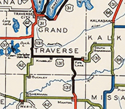 1938 (Dec 1) 1938 (Dec 1)  – The "1939 Winter Michigan Highway Map" is issued by the State Highway Dept and shows US-131 extended westerly from the Fife Lake area replacing M-113 through Kinglsey, then northerly with M-42 (present-day M-37) to a new northern terminus at US-31 in Chums Corners south of Traverse City. That same map still shows M-131 running from US-131 west of Fife Lake north-northeasterly through Petoskey to Harbor Springs. And while the department's own "Biennial Report Map" showing the trunkline system as it was as of July 1, 1938 also included this extension of US-131 via Kingsley to Chums Corners (see snippet at right), that map is not widely available to the public. Once the change shows up on the official highway map, though, local news reports state that's when "the fireworks started." In fact, State Highway Commissioner Murray D. Van Wagoner stated "the marking of the highway maps was an error and that M-131 would be changed to US-131 on north to Petoskey at once, just as soon as markers could be secured, and that in any event the spring highway map would show the change even though the shield-shaped markers were not ready." According to the media reports, "When the state winter highway maps were being made somebody somewhere took it upon themselves to show US-131 extended from Fite Lake to join US-31 seven miles south of Traverse City..." While this would finally "complete" the route of US-131 through to its "parent" route (US-31) after no progress in over a decade to construct a new highway alignment for the proposed US-131 from Fife Lake to US-31 at Acme, the changes are pegged as a cartographic error. – The "1939 Winter Michigan Highway Map" is issued by the State Highway Dept and shows US-131 extended westerly from the Fife Lake area replacing M-113 through Kinglsey, then northerly with M-42 (present-day M-37) to a new northern terminus at US-31 in Chums Corners south of Traverse City. That same map still shows M-131 running from US-131 west of Fife Lake north-northeasterly through Petoskey to Harbor Springs. And while the department's own "Biennial Report Map" showing the trunkline system as it was as of July 1, 1938 also included this extension of US-131 via Kingsley to Chums Corners (see snippet at right), that map is not widely available to the public. Once the change shows up on the official highway map, though, local news reports state that's when "the fireworks started." In fact, State Highway Commissioner Murray D. Van Wagoner stated "the marking of the highway maps was an error and that M-131 would be changed to US-131 on north to Petoskey at once, just as soon as markers could be secured, and that in any event the spring highway map would show the change even though the shield-shaped markers were not ready." According to the media reports, "When the state winter highway maps were being made somebody somewhere took it upon themselves to show US-131 extended from Fite Lake to join US-31 seven miles south of Traverse City..." While this would finally "complete" the route of US-131 through to its "parent" route (US-31) after no progress in over a decade to construct a new highway alignment for the proposed US-131 from Fife Lake to US-31 at Acme, the changes are pegged as a cartographic error. |
| |
 1939 (mid-Apr, June) – As noted above, highway crews change out all M-131 route markers from the southern terminus of that route (also the de facto northern terminus of US-131 since May 1927) with new US-131 signs through Kalkaska, Mancelona and Boyne Falls to US-31 at Petoskey in mid-April, leaving M-131 to only run concurrently with US-31 from US-131's new northern terminus through Petoskey and Bay View, then around the eastern end of Little Traverse City to its terminus in downtown Harbor Springs. This represents a major change to the routes of both US-131 and M-131. The American Association of State Highway Officials (modern-day AASHTO) receives the request for this change from the State Highway Dept early in the year and it is approves at their June meeting. 1939 (mid-Apr, June) – As noted above, highway crews change out all M-131 route markers from the southern terminus of that route (also the de facto northern terminus of US-131 since May 1927) with new US-131 signs through Kalkaska, Mancelona and Boyne Falls to US-31 at Petoskey in mid-April, leaving M-131 to only run concurrently with US-31 from US-131's new northern terminus through Petoskey and Bay View, then around the eastern end of Little Traverse City to its terminus in downtown Harbor Springs. This represents a major change to the routes of both US-131 and M-131. The American Association of State Highway Officials (modern-day AASHTO) receives the request for this change from the State Highway Dept early in the year and it is approves at their June meeting. |
| |
1939 (Nov 8) – The route of US-31/M-131 on the west side of Petoskey is relocated onto new alignment (Mitchell St) from jct US-31 & US-131 at the cnr of Spring St & Charlevoix Ave northeasterly and easterly into downtown. At the moment, this is a marked-and-maintained route—technically not transferred to state control yet, but signed and maintained by the State Highway Dept as a trunkline route. The former route easterly via Charlevoix Ave, northerly via Connable Ave, easterly via Jackson St and northerly via Liberty St to Mitchell St remains an unsigned state trunkline route for the time being. |
| |
1939 (Nov 12) – The new marked-and-maintained route of US-31/M-131 into downtown Petoskey from the west/southwest signed for the first time the previous November is officially established as a state trunkline route. Simultaneously, the former route easterly from the US-31 & US-131 jct via Charlevoix Ave, northerly via Connable Ave, easterly via Jackson St and northerly via Liberty St to Mitchell St is turned back to municipal control. |
| |
1942 (Jan 28) – A 0.46-mile segment of M-131/Harbor-Petoskey Rd from the Harbor Springs east city limit easterly is cancelled as a state trunkline route while simultaneously a new 0.3-mile alignment for M-119 is established bypassing the cancelled segment is officially established. The former route, which features older, narrow pavement, is much closer to the bluff overlooking the Little Traverse Bay and becomes part of a park access roadway. The new alignment is constructed to more modern highway standards and the $28,300 construction project is completed by the end of the construction season. |
| |
1943 (Mar 12–Apr 21) – State Rep. John C. Guggisberg of Gaylord introduces a House bill on March 12 "authorizing" the State Highway Commissioner to establish an extension to M-131 from Harbor Springs through Good Hart to Cross Village (which had temporarily been part of M-131 from 1933–1937), then northeasterly along Sturgeon Bay and Cecil Bay to a terminus in Mackinaw City. The bill would also authorize the establishment of a state trunkline from Cross Village easterly through Levering to Cheboygan (along modern-day C-66). However, 40 days later on April 21, Governor Harry F. Kelly vetoes the bill and while he personally believes in the project, he is also wary of returning to highway selections being determined by the legislature and doesn't believe this route is a necessary one while "more vital stretches of roadway" are needed to support the War effort. |
| |
1945 (Jun 5–26) – The State Administrative Board approves a request by State Highway Commissioner Charles M. Ziegler on June 5 to re-establish M-131 between Harbor Springs and Petoskey. The explanation given was that Ziegler stated it "will provide a tourst asset in a route which skirts the edge of Lake Michigan on an elevation." The 21.1-mile extension of M-131, which temporarily existed from 1933–1937, is again re-established as a state trunkline route on June 26, more than tripling the length of M-131 in the process. It is unclear if the efforts of State Rep. Guggisberg from two years prior had an effect on this re-establishment or not. |
| |
1955 (Mid) – The final portion of gravel-surfaced M-131, from Good Hart to Cross Village, is hard surfaced in mid-1955. |
| |
c.1959 – In an odd turn of events, one internal Michigan State Highway Dept map (nothing released for public consumption) seems to indicate highway planners are contemplating using the M-131 designation for significant portions of the Grand Rapids Beltline System once the US-131 designation is removed and placed onto the new north-south "Grand Rapids Freeway" currently under contruction. The map shows the proposed M-131 beginning at the US-131 freeway interchange south of Grand Rapids and proceeding easterly via 28th St to East Beltline Ave, then northerly along East Beltline Ave back to US-131 at Plainfield Ave & Northland Dr northeast of the city. Interestingly, though, M-131 still exists along the route from Petoskey through Harbor Springs to Cross Village. It is not clear what highway planners would have done with that route designation if the M-131 designation was moved down to the Grand Rapids area. |
| |
1964 (Dec) – The Emmet Co Road Commission conducts a Scenic Route Study in the M-131 corridor. |
| |
1967 (Jan 30) – Internal State Highway Dept maps present a confusing situation with regard to the route of M-131 in the Birchwood Farms/Five Mile Creek area between Harbor Springs and Good Hart. Highway department State Trunkline Determination Maps whose purpose it is to document every previous and existing trunkline route—ever—along with establishment/cancellation dates and official lengths indicate that a 4.120-mile trunkline route for M-131 is established along Lake Shore Dr (present-day M-119) between the Lower Shore Dr intersections, while the 3.360-mile segment of Lower Shore Dr, also known as the "Lake Shore Cutoff," is cancelled as a state trunkline route and, assumedly, turned back to county control. However, other internal State Highway Dept maps and documentation as well as contemporary aerial photography show Lake Shore Dr as being the route of M-131, likely all the way back to when it was re-established between Harbor Springs and Cross Village in mid-1945. So, until and unless additional clarifying information is ever located, it seems this establishment and cancellation may be a rectification of incorrect establishment records from 1945. (The 1933–37 "temporary" establishment of M-131 between Harbor Springs and Cross Village did seem to use Lower Shore Dr—the "Lake Shore Cutoff"—route, however, and this may be the source of confusion here.) |
| |
1969 (Sept 18, Dec) – The Dept of State Highways announces on September 18 the M-131 designation will be removed from the route of US-31/M-68 through Petoskey and Bay View, "in a move to simplify route numbering in the Petoskey area." Until now, the route from the cnr of Spring St & Charlevoix St on the west side of Petoskey and the cnr of Bay View Rd & Harbor–Petoskey Rd east of Bay View has borne three route designations: US-31/M-68/M-131, with the latter serving as a northerly extension of US-131 which terminates at Spring & Charlevoix Sts. The Dept of State Highways states the M-131 route markers will be removed from US-31/M-68 by the end of December and the route's new southern terminus will be at "Chimney Corners" at US-31 east of Bay View (the present-day southern terminus of M-119). |
| |
1972 (Summer) – The Emmet County Lakeshore Association (ECLA) is formed by "like-minded" property owners to protect and preserve the M-131 corridor between Harbor Springs and Cross Village. |
| |
1979 (Oct 5) – The entirety of M-131 is redesignated as M-119 to reduce confusion with the two other nearby highways with "31" in their designations: US-31 and US-131. M-131-turned-M-119 begins at "Chimney Corners" at US-31 east of Bay View and continues via Harbor Springs and Good Hart to a terminus at jct C-66/C-77 in Cross Village. Eighty M-131 route markers were swapped out for new M-119 signs. One internal MDOT source, however, indicates M-119 (and M-131 before it) as beginning at jct US-31 & US-131 (cnr Charlevoix Ave & Spring St) on the west side of Petoskey and continuing easterly via US-31 through Bay View to the present-day beginning of M-119 before turning northerly toward Harbor Springs. As the Dept of State Highways had removed the M-131 route markers from US-31 through Petoskey and Bay View a decade prior, it is unclear if the department still considers M-131-turned-M-119 to officially still begin at the northern terminus of US-131 or if it was simply a mapping error. Regardless, the 52-year history of the existence of the route of M-131 comes to a close with the change. |
| Controlled Access: |
No portion of M-131 was freeway or expressway upon the route's decommissioning. |
| Photographs: |
|
| Weblinks: |
|
| |
|

