| Western Terminus: |
M-37 six miles north of Buckley and six miles south of Chums Corners in southwestern Grand Traverse Co |
| Eastern Terminus: |
US-131 at Walton (Junction), 4 miles south of Fife Lake in southeastern Grand Traverse Co |
| Length: |
16.573 miles |
| Maps: |
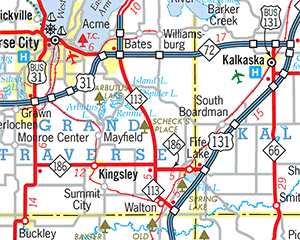
Route Map of M-113 |
| Notes: |
M-113 is a short but key connecting route in Northwest Michigan, serving as the primary conduit for Traverse City-bound traffic from the US-131 corridor heading north from Cadillac. This is evidenced by the traffic volume on US-131 north of the M-113 junction being approximately 58% less than it is south of the junction. From US-131, Traverse City-area bound traffic will either use M-113 in its entirety, connecting with M-37 and US-31 heading north into the western part of the metro area, or turning northerly off M-113 at Kingsley to access the East Bay area. |
| |
From 1927 until 1939, the northern terminus of US-131 was located at the present-day jct of M-113 & M-186 west of Fife Lake. At that time, the present-day US-131 corridor northerly from M-113 toward Petoskey was designated M-131. In that period, long-range plans existed to extend US-131 north-northwesterly on new alignment to meet its parent route, US-31, east of Traverse City, near Acme. Until 1939, US-131 did not come in contact with US-31 at all! |
| |
In "State Trunkline Needs, 1960–1980," a set of maps prepared by the State Highway Dept's Office of Planning, Programming Division in 1960 showing possible additions, upgrades and improvements to the state trunkline system over the ensuing twenty years, MSHD staff recommended the following changes to the route of M-113 during that timeframe:
- Extending M-113 from its eastern terminus at US-131 for less than one mile to meet up with a proposed US-131 freeway running roughly parallel to the existing route, but passing south and east of Fife Lake rather than west and north of it. Obviously, since the US-131 freeway proposal was never implemented in this area, M-113 was never extended to meet it.
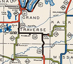
 By far, however, the greatest suggested change was to finally construct the original US-131 extension between the Fife Lake area and Acme, but as a two-lane M-113 route instead. M-113 would continue northerly from the 90° turn approximately ½ mile north of the M-186 junction, then gradually bend to the west, passing between Rennie and Island Lakes before curving back to north to intersect the proposed US-31 & M-72 freeways at an interchange in the midst of the present-day VASA Pathway system. Existing M-113 from the 90° westerly through Kingsley to M-37 would, assumedly, become a western extension of M-186. (See map at right.) Along with the proposed US-31 and M-72 freeways, this proposal would never come to fruition. By far, however, the greatest suggested change was to finally construct the original US-131 extension between the Fife Lake area and Acme, but as a two-lane M-113 route instead. M-113 would continue northerly from the 90° turn approximately ½ mile north of the M-186 junction, then gradually bend to the west, passing between Rennie and Island Lakes before curving back to north to intersect the proposed US-31 & M-72 freeways at an interchange in the midst of the present-day VASA Pathway system. Existing M-113 from the 90° westerly through Kingsley to M-37 would, assumedly, become a western extension of M-186. (See map at right.) Along with the proposed US-31 and M-72 freeways, this proposal would never come to fruition. |
| History: |
1927 (Nov 21) – A new, 12.5-mile long state trunkline, designated M-113, is established in southern Grand Traverse Co, from M-42 (present-day M-37) on the west, easterly through Kingsley to jct US-131 & M-131 on the east, near Fife Lake (at present-day jct M-113 & M-186). |
| |
 1938 (Dec 1) 1938 (Dec 1)  – The "1939 Winter Michigan Highway Map" is issued by the State Highway Dept and shows US-131 extended westerly from the Fife Lake area replacing M-113 in its entirety, then northerly with M-42 (present-day M-37) to a new northern terminus at US-31 in Chums Corners south of Traverse City. That same map still shows M-131 running from US-131 west of Fife Lake north-northeasterly through Petoskey to Harbor Springs. And while the department's own "Biennial Report Map" showing the trunkline system as it was as of July 1, 1938 also included this extension of US-131 via Kingsley to Chums Corners (see snippet at right), that map is not widely available to the public. Once the change shows up on the official highway map, though, local news reports state that's when "the fireworks started." In fact, State Highway Commissioner Murray D. Van Wagoner stated "the marking of the highway maps was an error and that M-131 would be changed to US-131 on north to Petoskey at once, just as soon as markers could be secured, and that in any event the spring highway map would show the change even though the shield-shaped markers were not ready." According to the media reports, "When the state winter highway maps were being made somebody somewhere took it upon themselves to show US-131 extended from Fite Lake to join US-31 seven miles south of Traverse City..." While this would finally "complete" the route of US-131 through to its "parent" route (US-31) after no progress in over a decade to construct a new highway alignment for the proposed US-131 from Fife Lake to US-31 at Acme, the changes are pegged as a cartographic error. – The "1939 Winter Michigan Highway Map" is issued by the State Highway Dept and shows US-131 extended westerly from the Fife Lake area replacing M-113 in its entirety, then northerly with M-42 (present-day M-37) to a new northern terminus at US-31 in Chums Corners south of Traverse City. That same map still shows M-131 running from US-131 west of Fife Lake north-northeasterly through Petoskey to Harbor Springs. And while the department's own "Biennial Report Map" showing the trunkline system as it was as of July 1, 1938 also included this extension of US-131 via Kingsley to Chums Corners (see snippet at right), that map is not widely available to the public. Once the change shows up on the official highway map, though, local news reports state that's when "the fireworks started." In fact, State Highway Commissioner Murray D. Van Wagoner stated "the marking of the highway maps was an error and that M-131 would be changed to US-131 on north to Petoskey at once, just as soon as markers could be secured, and that in any event the spring highway map would show the change even though the shield-shaped markers were not ready." According to the media reports, "When the state winter highway maps were being made somebody somewhere took it upon themselves to show US-131 extended from Fite Lake to join US-31 seven miles south of Traverse City..." While this would finally "complete" the route of US-131 through to its "parent" route (US-31) after no progress in over a decade to construct a new highway alignment for the proposed US-131 from Fife Lake to US-31 at Acme, the changes are pegged as a cartographic error. |
| |
1939 (mid-Apr) – As noted above, highway crews change out all M-131 route markers from the southern terminus of that route (also the de facto northern terminus of US-131 since May 1927) with new US-131 signs through Kalkaska, Mancelona and Boyne Falls to US-31 at Petoskey. According to news reports, it seems no US-131 route markers are ever placed along the route of M-113 and no actual changes to M-113 ever occur in the field related to this entire event. |
| |
1940 (Aug 17) – A nearly five mile section of new state trunkline alignment is added to the highway sytem when US-131 is officially established via its present-day route between Walton Junction and the jct with present-day M-186 on the western edge of Fife Lake. The former route of US-131 from Walton northerly 4 miles is redesignated as a southerly extension of M-113, while the east-west segment from M-113 easterly to the new alignment on the west edge of Fife Lake receives a brand-new route designation: M-186. |
| |
1945 (June 26) – The 1.1-mile long segment of M-113 through the community of Walton in southeastern Grand Traverse Co is bypassed by a new 0.2-mile long connection between present-day Union St and the new US-131 alignment opened in 1940. The former route of M-113 along Union St through Walton is turned back to county control. The net loss to the length of M-113 is 0.9 miles. |
| |
1979 (June 1) – A new angling "cut-off" route is established as a state trunkline, beginning on M-113 just east of Hodge Rd (5 miles east of Kingsley) and trending slightly southeasterly, crossing the existing M-113 approximately ¼ mile north of the M-186 junction and ending on M-186 approximately 1 mile east of M-113 (1½ miles west of US-131 at Fife Lake). Four decades later, this realignment has yet to be built and may have been removed from the books at some point during the 1990s. |
| Controlled Access: |
No portion of M-113 exists as freeway or expressway. |
| NHS: |
No portion of M-113 is on the National Highway System (NHS). |
| Memorial Highway: |
At present, no portion of M-113 has been designated as part of a Memorial Highway. |
| Photographs: |
|
| Weblinks: |
|
| |
|