

Diagonal Highways, 1935-36
The following text was excerpted from the 1935-1936 "Sixteenth Biennial Report of the State Highway Commissioner" which includes a map illustrating the routes discussed. The text has been transcribed as-is with a present-day "epilogue" at the end to discuss which of these routes was completed and which remained only lines on a map. Clicking on the included map will bring up a larger version.
Diagonal Highways
Diagonal routes to obviate the excessive travel distances imposed by a section line or rectangular system of highways, were planned in the previous biennium [1932-34, –ed.] and construction on three of these routes was carried on during the past two years.
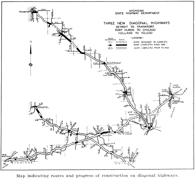
Clare-Frankfort Diagonal. A diagonal route between Clare and Frankfort was laid out during the first year of the biennial period [e.g. 1934, –ed.] which will greatly shorten the road distance between the industrial area in the southeastern part of the Lower Peninsula and the northwestern part of the State. When completed, it will afford almost straight-line communication from Detroit to Frankfort and thence by ferry to Menominee.
Trunk-line US-10 from the metropolitan area to Farwell, constitutes the greater part of this diagonal, but from Farwell to Frankfort an entirely new road is being built. Construction was initiated on 13 miles of this new section in Osceola County in the last year of the biennium.
Holland-Toledo Diagonal. A second diagonal is the so-called Holland-Toledo route, which will give much better access to the Lake Michigan shore resorts for tourists from Ohio.
This highway as now laid out serves Allegan, Battle Creek, Marshall, Albion and Adrian, and utilizes existing roads except for a section which will be constructed between Somerset Center and Albion. Gravel sections now in place in Allegan, Barry, and Calhoun Counties are to be replaced with pavement; and projects northwest of the city of Allegan, involving eight miles of highway have been completed and two miles are now under construction.
Chicago-Montreal Highway. The third diagonal is the Chicago-Montreal Highway, which crosses lower Michigan from New Buffalo to Port Huron. The route selected with connect Niles, Three Rivers, Union City and Jackson over M-60 and US-12. The paving of an 18-mile gap northwest of Union City will provide a hard surface between the Indiana state line, southwest of New Buffalo, and Chelsea in Washtenaw County. About four and a half miles of this gap was graded and paved during the biennium.
The new construction on US-12 betwen Jackson and Chelsea, which was mentioned above [in an earlier section of the report, –ed.], is included in the Chicago-Montreal route. From Chelsea a new road is contemplated to connect with M-218 in the vicinity of Wixom in Oakland County. From Pontiac to Port Huron the present M-59 and US-25 will serve traffic until the construction of a more direct route is possible.
At Port Huron an International Bridge is proposed for construction across the St. Clair River under the direction of the State Bridge Commission. The State Highway Department and the Ontario Highway Commission are cooperating with the State Bridge Commission in the plans for this project and are under contract to build the respective approaches to the main structure. Clearing of the right of way and borings on the American side have already been started.
Diagonal Highways: Epilogue
Only one of these three routes eventually came to fruition and the one that did was constructed exactly as planned with no major changes. Almost no additional work was ever performed on the other two diagonals beyond what was shown as complete on the map above. It may have been that World War II interrupted those plans and then both changing traffic patterns and the move toward "superhighways" (expressways and freeways) in the post-war era shifted highway planner's focus onto other routes. In 1957, the unbuilt portions of the remaining "diagonals" were officially cancelled by the State Highway Department and were relegated into history.
Clare-Frankfort Diagonal: US-10 and M-115
Other than some spot improvements to the route of US-10 in the cities of Detroit and Flint and the stretch of US-10 between Clare and Farwell, the rest of this diagonal was to consist of entirely new highway and was eventually designated as M-115. M-115 had started out in 1929 as a short route connecting Frankfort and Benzonia, although it wouldn't officially become a state trunkline highway until March of the next year. The final routing of M-115 between those cities was completed in 1935, but that same year fate would intervene to transform M-115 from a 6.4-mile long connecting route into an almost 100-mile long major through route.
 On January 7, 1935, a 58.8 mile new trunkline routing was established (officially made part of the state highway system) between Mesick and Farwell and construction began. Various segments opened over the next seven years, with the segment from Mesick to Benzonia being officially established in segments on August 30, 1937 and January 28, 1942. By the outbreak of World War II, M-115 existed in two segments: From Farwell to Cadillac and from Mesick to Frankfort; the gap in the middle through the center of Wexford County would have to wait until the war was over. In the early 1950s, a county road roughly along the line of the proposed M-115 was built between Cadillac and Mesick and in 1957 that road was assumed into the state highway system and the Clare-Frankfort Diagonal was complete.
However, by that time, changing traffic patterns were starting to alter the overall routing of a Detroit-to-Frankfort highway, with the Saginaw-Midland portion of the route eventually relegated to secondary status as M-47 and freeways being constructed between Saginaw and Bay City and Midland and Bay City. US-10 would be redirected along that alignment instead. But the importance of the Clare-Frankfort Diagonal (and the larger Detroit-Frankfort highway) have been reaffirmed, with freeways being constructed in that corridor over nearly two-thirds of its length and the remainder being upgraded with numerous passing lanes and other improvements over the decades since. M-115 remains a major highway connecting Central and Southern Michigan with the resorts and vacation areas of Northwest Michigan, including Manistee, Traverse City, and the Sleeping Bear Dunes region.
Toledo-Holland Diagonal: US-223, M-89 and M-40
Unlike M-115 and the Clare-Frankfort Diagonal, no additional work was ever done to connect the completed portions of the Toledo-Holland Diagonal after 1936. While the two portions that were completed remain moderately-used highways today, a good portion of the through traffic in the areas they serve have been diverted to area freeways, ironically none of which run diagonally.
The southeastern portion of this diagonal is made up of US-223 between the Ohio state line and US-127 in the Irish Hills. It serves traffic to and from Adrian as well as a connection from there into the Jackson area. In the 1990s and early 2000s, federal transportation funding legislation included the concept of an "I-73" running from South Carolina to Northern Michigan and one of the most probable routes in southeastern part of the state was to roughly follow the US-223 corridor and then US-127 north into Jackson. After some study, the idea of I-73 in Michigan was abandoned and US-223 today remains largely a two-lane, rural highway.
The segment of highway to have joined the two existing diagonals along this route was to have run from the northern (western) terminus of US-223 in the Irish Hills to US-12 (now I-94) in the Albion area, where the route would have followed US-12/Michigan Ave between Albion and Battle Creek, where it would have transitioned to the M-89 alignment. The Irish Hills-to-Albion segment had been determined as a future trunkline route on January 7, 1935, the same day as a major segment of the Clare-Frankfort Diagonal was determined, and was officially cancelled on June 24, 1957.
Between Battle Creek and Holland, the diagonal followed M-89 to Allegan and M-40 from there to Holland. Today, that route remains a well-traveled through route, especially between US-131 at Plainwell and Holland, passing through Allegan en route. Old planning maps indicate bypasses for Allegan and Otsego-Plainwell had been proposed and likely never came to fruition once the overall diagonal concept was shelved. Interestingly, in recent years there has been local pressure in the Allegan area for an M-89/M-40 bypass of the city to remove the higher-than-desired levels of truck traffic from travelling through the city.
Official State Highway Department maps from the 1930s through 1950s indicated the unbuilt diagonal portion from US-12 to Albion was to have been an extension of US-223 and designated as such. No clear indication has ever been found to date though, that the US-223 designation was to have been extended to Holland, although doing so would have served to "legitimize" of US-223 as some have questioned the existence of such a short US Highway serving relatively limited traffic.
Chicago-Montreal Highway: The Ghost of M-218
With the exceptions of a new M-60 bypass of Union City (bypassed one year later in 1937), the southern US-12 bypass of Chelsea (completed in 1940), and the International Bridge between Port Huron and Sarnia, Ontario, no further work on the Chicago-Montreal Highway was ever started or completed. The portion left undone was the segment designated as M-218.
M-218 started off as a winding, back route connecting US-16 south of Wixom to Pontiac, largely following Wixom Rd, Pontiac Tr and Orchard Lake Rd. Few upgrades were ever made to the highway and certainly not the types of upgrades one would assume both a "Chicago-Montreal Highway" as well as an effective northern bypass of the Detroit Metropolitan area would have gotten.
Once the Chicago-Montreal Highway diagonal route was proposed in 1935, southwesterly and northeasterly extensions of M-218 were officially proposed. From Wixom, M-218 was to travel southwesterly to South Lyon, then skirting Whitmore Lake to the south, passing near or through Dexter and merging with US-12 east of Chelsea. From Pontiac, M-218 was to have continued generally easterly south of the existing M-59 alignment to Utica where it would have turned more northeasterly to a junction with US-25/Gratiot Ave in the New Haven area. It seems the plan was to have M-218 bypass downtown Pontiac to the south, possibly along the Square Lake Rd alignment used by present-day BL I-75 and BUS US-24. In fact, it was reported in August of 1936 in conjunction with the authorization of $650,000 in federal funds to begin work on the Michigan approach to the new Blue Water Bridge at Port Huron, that Thomas H. MacDonald, chief of the federal Bureau of Public Roads noted the federal government "favored the completion of a diagonal highway from Chicago to Port Huron via Jackson, Chelsea and Pontiac."
Even today, the best route for the 850-mile trip between Chicago and Montreal remains through southern Lower Michigan, although following freeway alignments which somewhat parallel the route of the once-proposed diagonal highway. Most online mapping services will route a driver between those two cities via I-94 from Chicago to Port Huron and then via Ontario Hwys 402 and 401. A popular alternate route by many drivers—coming in at the same number of miles and same amount of driving time (if not less factoring in traffic and construction in the Detroit area) is to use I-69 between Marshall and Port Huron. This route somewhat echoes the original M-218 proposal of arcing around the northern fringes of Metropolitan Detroit, although I-69 does it is a much wider arc. (Of course, Metropolitan Detroit is a much bigger area today than it was in 1936!)
M-218 was cancelled as a state trunkline highway in 1963 and turned back to local control. Ironically, the M-5/Haggerty Connector—constructed in the 1990s along a portion of the right-of-way reserved for an I-275 bypass of Metro Detroit—ends at Pontiac Trail... the former M-218 and the one-time proposed route of the Chicago-Montreal Highway.
Additional Information
- Diagonal Highways Map, 1936 - a larger version of the map included in this article.