

Michigan's Route Markers
From the earliest times of numbered and marked state trunklines in Michigan, the standard state route marker has been the shape of a diamond with a block letter "M" in the upper corner. Early on, the diamond was taller than wide, had the words "STATE TRUNKLINE" across the widest part and the "M" and the route number were of the same size.
These early route markers would either be erected on stand-alone posts or on telephone and electric line poles along the highway. (Utility poles close by the side of the travelled-way were much more common in the first half of the 20th century.) Quite often, the "new" state trunkline marker of the late 1910s and early 1920s was applied directly over or adjacent to the colored bands designating one or more Named Auto Trails. By the 1930s, the diamond had been "squashed" down so that all angles were at 90 degrees.
The ubiquitous Michigan diamond state route marker was reportedly designed by Allan M. Williams (1892–1979) who joined the Michigan State Highway Department as a project engineer in 1918 and, in conjunction with a $50 million dollar highway bond issue in 1919, he drafted the state's first complete highway map. Since Michigan began designating and signing its state trunkline highways at this time, it is quite possible Mr. Willliams did, indeed, design the original state trunkine route marker. While Williams became engineer-manager of the Ionia County Road Commission in 1919, he also continued in a dual role as project engineer for the state highway department until 1927 and held his position with Ionia County until his retirement in 1957.
 In January 1961, in response to a letter sent by a Mrs. Virgil Parker of Monroe, State Highway Commissioner John C. Mackie officially rejected the suggestion that Michigan's state trunkline route markers include the outline of the state in them instead of the familiar diamond shape which had been used for 43 at that point. Mackie stated, "Michigan's silhouette would produce an awkward shape difficult to mount on a sign" in his response to Parker. As the 1960s were still the era of cutout route markers, Mackie was likely referring to attempting to produce a two-peninsula cutout sign for the route markers (instead of a square or rectangular sign that is common today), which would've been quite difficult and costly to do. While not what would've been envisoned in Mackie's day, the two images at right are two modern-day possibilities as to what a state outline-version of the Michigan state trunkline route marker could look like. The top example shows how tiny the route number would need to be (and how utterly impossible it would be for three-digit routes), while the bottom example does allow for much larger numerals, a goodly portion of the outline of the Lower Peninsula would need to be obscured for this option to work. Since the 1961 suggestion by Mrs. Parker, there has been no known serious attempt to redesign the familiar Michigan diamond.
In the early 1970s when U.S. federal government mandated updated and standardized traffic signage, the traditional Michigan "cutout" diamond was then incorporated with a square black sign "blank," as it is today. For four decades, the Michigan state trunkline marker has remained relatively unchanged.
This page attempts to illustrate the many and varies types of route markers used on Michigan's highways, from Interstate, US and State highways to National Forest routes, Great Lakes Circle Tours, county roads and others. Pick a type of route marker to jump directly to it:
Interstate | US Highway | State | County | Forest | Circle Tour | Byway/Heritage | Other
 |
 |
 |
 |
Original style Interstate route marker adopted in the late 1950s and in use into the 1980s. |
Newer-style Interstate route marker omits the state name, allowing for larger and easier-to-read numerals. |
Interstate Business Loop route marker, commonly used in Michigan. |
Interstate Business Spur route marker is less common due to a smaller number of these routes. |
|
Interstate Highway Markers (3-digit Loop & Spur Routes)
|
|||
 |
 |
 |
 |
Original style Interstate three-digit route marker adopted in the late 1950s and in use into the 1980s. |
Newer-style Interstate three-digit route marker omits the state name, allowing for larger and easier-to-read numerals. |
Three-digit Interstate Business Loop route marker, commonly used in Michigan. |
Three-digit Interstate Business Spur route marker is less common due to a smaller number of these routes. |
 |
 |
 |
 |
Original "cutout" style US Highway route marker adopted in 1927 and in use into the late 1940s. Wider three-digit markers did not exist at this point. |
In 1948, the US Highway route marker began using the "new" FHWA typeface, but was otherwise unchanged in shape. It remained in use into the 1970s. |
Although it seems it may not have been adopted nationally, Michigan did use a wider variant of the 1948 cutout US Highway route marker for three-digit highways into the 1970s as well. |
This "Outline Sign" was used in from 1948 into the 1960s for junction, target and overhead route marker assemblies. A wider three-digit marker also existed. |
 |
 |
 |
 |
While the US Highway maker was revised in 1961 to include a black "sign blank" background, Michigan continued using the 1948 version until this 1971 modified version was adopted. The state converted to this style still used today. |
The modern-day three-digit US Highway route marker, also adopted in 1971 when Michigan converted from using the 1948 version. |
The modern-day three-digit US Highway route marker using the narrower "Series C" of the FHWA typeface to accommodate larger numbers. |
As Michigan has two US Highways with two "1"s in their designations, many US-131 and US-141 route markers have been posted using the two-digit route shield. |
 |
 |
 |
 |
These are two representations of early state trunkline route markers from the 1920s, one wrapped around a utility pole (L) and the other an independently-mounted sign (R). |
A more standard state highway route marker was settled upon in 1926 concurrent with the adoption of the first U.S. Highway route marker. |
When the U.S. Highway route marker was modified to use the "new" FHWA typeface in 1948, the Michigan state trunkline marker followed suit with regard to the numerals. The "block M" remained as it was, however. |
Again, when the FHWA updated the U.S. Highway route marker specification in 1971 to use black "sign blanks" as a background, Michigan followed suit to create its current style of route marker. |
 |
 |
 |
 |
Another rendition of the present state highway marker, this one showing how three-digit route numbers appear using the "Series C" FHWA typeface. |
Initially, the only reassurance or other independently-mounted state highway markers in an elongated
format appeared along M-553 in Marquette Co. Today, a smattering of other routes (e.g. M-199) also use them. |
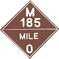
A very unique route, Mackinac Island's M-185 is the only "motorless state highway" and sports unique signage, including distances from the visitor center. |
Another unique trunkline route was the CAPITOL LOOP (1989–2024) in downtown Lansing which functioned as a loop off I-496, but had its own unique markers. |
 |
 |
 |
 |
The standard Intercounty Highway route marker, although this one is unique in that A-2 is the only 'two-character' route. The marker was created in 1967 by the National Assoc. of Counties as part of their National Uniform County Route Marker Program. |
Another Intercounty Highway route marker, this one uses a hyphen between the letter and numbers. There is no concensus between the "with" and "without" hyphen styles and both styles may be seen along the same route. |
Some counties in Michigan sign their own county routes, such as Gogebic illustrated above, using the standard National Assoc. of Counties route marker. |
Many other counties opt to use an older style of county route marker: a square white (or sometimes green) blank with the county name and route number in the center. |
 |
 |
 |
 |
Federal Forest Highway route markers appear in several of Michigan's national forests. These are high-quality, well-maintained (usually all-weather) highways. |
Secondary Forest Road sign, used on roads generally open to automobile travel and closed to ORV use. These roads can range from paved to one-lane gravel. |
Low-Standard Forest Road signs are used for roads which may be open to motorized use or may be closed to all but ORV or foot traffic. These range from one-lane gravel to two-track. |
The National Forest Scenic Byway sign is used in many places across the U.S., specificially in Michigan on the Black River Harbor Scenic Byway north of Bessemer. |
 |
 |
 |
 |
The Great Lakes Circle Tour sign, used very sparingly in Michigan, although it does appear once in awhile. |
The Lake Erie Circle Tour route marker, appearing in only two Michigan counties: Monroe and Wayne. |
The Lake Huron Circle Tour route marker as it appears along Lake Huron shoreline routes in both peninsulas. |
The Lake Huron Circle Tour Loop route marker is used in the DeTour Village area. |
 |
 |
 |
 |
The Lake Michigan Circle Tour route marker is found along many miles of Michigan trunkline. |
The Lake Michigan Circle Tour Loop runs along M-109 in Leelanau Co. |
The Lake Michigan Harbor Tour is a locally-posted route in the Saugatuck-Douglas area. |
The Lake Superior Circle Tour route marker appears often throughout the U.P. |
 |
 |
||
The Lake Superior Circle Tour Loop marker appears along at least two highways in the U.P. |
The Lake Superior Circle Tour Scenic Spur formerly ran via M-77 from Seney to Grand Marais until c.2014. |
||
 |
 |
 |
 |
Pure Michigan Byway route marker. |
Historic Heritage Route marker. |
Recreational Heritage Route marker. |
Scenic Heritage Route marker. |
 |
 |
 |
|
The Blue Star Highway route marker is used along a portion of the former route of US-31 in Van Buren Co. |
The Oceana Circle Tour route marker appears along a locally-designated route in Muskegon and Oceana Cos. |
The Polar Equator Trail route marker can be found in Antrim, Otsego, Montmorency and Alpena Cos. |
The Red Arrow Highway route marker is used along the former route of US-12 in Van Buren and Berrien Cos. |
 |
 |
 |
 |
The Shoreline Trail route marker appears on a locally-designated route in Muskegon Co running along the Lake Michigan shoreline. |
In 2004, US-23 from Standish to Mackinaw City was designated as the Sunrise Side Scenic Highway and these route markers are posted along the route. |
This "US-41 Scenic Route" marker was used from the late-1960s until 1999 along US-41 in northern Keweenaw Co. |
The Mackinaw Scenic Shortway Route was posted along a mixture of state, county and local roads from 1938 until 1942. |
 |
In August 1964, the Michigan State Highway Dept experimented with signing the exits along I-94 using a milemarker-based system (far from the norm at the time—most other states numbering their interchanges in the 1960s still used the sequential numbering system). White-on-blue signs like the one at left were attached to the top the existing white-on-green freeway signs at each exit. These signs were replaced with "standard" exit signage a decade later beginning in 1974 when the MSHD began numbering and signing exits on the other freeways around the state. |
 M-78 south of Battle Creek and M-66 north of Battle Creek and US-131 from Kalkaska to Petoskey were designated as the Green Arrow Route in 1958. It is unclear how long any route markers were posted. |
|
Controversy on M-22
![]() In 2012, the M-22 route marker became the center of a legal and financial debate over whether a business can trademark a specific state highway route marker and prevent others from selling merchandise with the depiction of any other state highway route on it, not just the original one trademarked. In 2003, Matt and Keegan Myers began making and selling t-shirts and stickers featuring an approximation of the M-22 route marker (they don't utilize the actual FHWA typeface for the numerals "22") and started using the slogan, "M-22 is not just a road; it is a way of life." However, after a gift shop owner in Emmet County began making and selling M-119 route marker decals (ironically, properly rendering the "119" using the FHWA typeface), the Meyers' brothers threatened legal action. This got the State of Michigan involved in 2012 with the Attorney General issuing an opinion that route markers, such as the M-22 sign, are not copyrightable. A new level was reached in September 2016 when the State filed suit against the Meyers' company. Please see the M-22 Route Listing for more details.
In 2012, the M-22 route marker became the center of a legal and financial debate over whether a business can trademark a specific state highway route marker and prevent others from selling merchandise with the depiction of any other state highway route on it, not just the original one trademarked. In 2003, Matt and Keegan Myers began making and selling t-shirts and stickers featuring an approximation of the M-22 route marker (they don't utilize the actual FHWA typeface for the numerals "22") and started using the slogan, "M-22 is not just a road; it is a way of life." However, after a gift shop owner in Emmet County began making and selling M-119 route marker decals (ironically, properly rendering the "119" using the FHWA typeface), the Meyers' brothers threatened legal action. This got the State of Michigan involved in 2012 with the Attorney General issuing an opinion that route markers, such as the M-22 sign, are not copyrightable. A new level was reached in September 2016 when the State filed suit against the Meyers' company. Please see the M-22 Route Listing for more details.
Acknowledgements:
Nearly every route marker image above was created by Christopher J. Bessert and, therefore, all original graphics are copyrighted ©2008–2023 Christopher J. Bessert, All Rights Reserved. Please do not reproduce or otherwise use them without permission. Any commercial use is prohibited. While certain components of these markers are not "copyrightable," these graphics are copyrighted. If you'd like to use one of them, please ask first!
However, some acknowledgements and credit are necessary.
- Many thanks to Michael Adams and his "Roadgeek" typeface series used to create many of these rotue markers.
- Additional thanks to Bruce S Cridlebaugh and his "USHighwaysOldStyle" used for the 'original style' US and State route markers.
- Richard C. Moeur's "Sign Manual" website provided a few of the graphic bases used in creating these markers.
- James Lin's "Highway Route Markers" website provided much inspiration.
- The "Sunrise Side Coastal Highway" image is courtesy Michigan's Sunrise Side, Inc.
- The two earliest state trunkline markers ("M-2" and "M-11") were reproducted from a Rand McNally & Co. "Junior Auto Trails Map of Michigan," 1926.
Additional Information:
For more information on Michigan's state trunkline (and other) route markers, visit the following off-site sources:
- Highway Route Markers by James Lin, features highway markers from the US, Canada, Asia, Australia, Europe and Mexico.
 Highway Shields and University Logos – From Adam Prince: "Michigan, Wyoming, and, at one point, North Carolina. Three states that have or had what appears to be their flagship university's logo within their highway shield. Is that truly the case?"
- Road Signs of Michigan by Mark O'Neil. Also includes route markers and traffic signal photos from across the US.
- Michigan's Route Markers: The Clearview Future? – See what Michigan's route markers might look like if MDOT switches from using the FHWA typeface to the new Clearview typeface now being used on freeway guide signs.
- Allan M. Williams, 1892–1979 – an obituary originally posted on the Ionia County Road Commission website regarding the man who likely designed the Michigan state trunkline route marker in c.1918–1919. (Information now featured on this site's In Depth section.)
- Allan M. Williams (1892–1979) – a short article from the Michigan Transportation Hall of Honor (via archive, formerly on the MDOT website).