
|
Business Connections 32 through 94 | ||||||||||||||
 Hillman |
Southern Terminus: | Jct Hillman Rd & Veterans Memorial Hwy/Old M-32 on the south side of Hillman | |||||||||||||
| Northern Terminus: | |||||||||||||||
| Length: | 0.738 miles | ||||||||||||||
| Map: | |||||||||||||||
| Notes: | BUS M-32 is one of Michigan's quirkier highways in several ways. It does not appear on any maps—commercial, governmental or otherwise—and was only discovered through MDOT's "Roadway Physical Reference Number Atlas," in which it is listed. Field-checking expiditions have confrimed the existence of a few "BUSINESS M-32" route markers in the village of Hillman. However, no indication of BUS M-32 is given along M-32 south of town, at either the Hillman Rd or Veterans Memorial Hwy/Old M-32 intersections. With the completion of the M-32 "bypass" route, BUS M-32 no longer connects directly with M-32, still terminating Old M-32, approximately 1/2 mile shy of the new route of M-32. | ||||||||||||||
| Even though several MDOT sources and route markers in the field clearly designate this route as BUSINESS M-32, other maps and documents have assigned this route a different designation over the years, including SPUR M-32. (The Michigan state tunkline system officially has no "SPUR" routes, however.) | |||||||||||||||
| BUS M-32 is the shortest "Business Connection" in the state of Michigan, beating out BUS US-2 in Ironwood by 0.53 mile and Former BS I-96 at Portland by 0.55 mile for that title. This route also narrowly misses being the shortest overall state highway by 0.006 mile—that is six one-thousandths of a mile! (M-212 at Aloha has the honor of being the shortest state trunkline at 0.732 mile.) | |||||||||||||||
| History: | 1926 (Oct 20) – The entire length of State St in the Village of Hillman from M-32 on the south village limit northerly to the north village limit is transferred to the state and is assumed into the state trunkline system. As Michigan would not utilize "Business Routes" for another 15 years, it is unclear how this route was designated and/or signed... if at all at this time. | ||||||||||||||
| c.1994 – A small portion of what was proposed as a much larger relocation project is completed, routing M-32 on new alignment bypassing Hillman from Hillman Rd easterly to just west of the Montmorency/Alpena Co line. The former route of M-32 via Hillman Rd and Veterans Memorial Hwy (Old M-32) is turned back to local control, "orphaning" BUS M-32 in the process, leaving it disconnected from the remainder of the state trunkline system. | |||||||||||||||
| Freeway/Expwy: | No portion of BUS M-32 is freeway or expressway. | ||||||||||||||
| Photographs: | |||||||||||||||
| Weblinks: | • M-32 Spur/Thunder Bay River Bridge |
||||||||||||||
| • Hillman Bridge |
|||||||||||||||
| • Hillman Bridge and Streetscape Project |
|||||||||||||||
 Marquette |
Fmr West Terminus: | US-41/M-28 at Washington St intersection west of downtown Marquette | |||||||||||||
| Fmr East Terminus: | US-41/M-28 at Front St intersection on the south side of downtown Marquette | ||||||||||||||
| Former Length: | 2.165 miles | ||||||||||||||
| Map: | Route Map of FORMER BUS US-41 | ||||||||||||||
| Notes: | This highway, obviously, was a former routing of US-41/M-28 through downtown Marquette before the downtown bypass highway was constructed. Sources seem to indicate BUS US-41 was also formerly co-signed with BUS M-28, mirroring the one-time US-41A/M-28A designations along present-day BUS M-28 at Ishpeming-Negaunee. | ||||||||||||||
| Marquette's BUS US-41 routing is no longer. Since the designation of M-553 along what had been Co Rd 553 from the southern portion of Marquette to Gwinn in 1998, MDOT had been attempting to negotiate with the City of Marquette to transfer the last "missing link" portion of McClellan Ave in order to bring M-553 to a logical northern terminus at US-41/M-28 west of downtown. Until 2005 the City seemed unwilling to negotiate when WLUC-TV 6 reported the City was in talks with MDOT to trade McClellan from the northern end of M-553 to US-41/M-28 in exchange for the state turning over jurisdiction of all of BUS US-41 through downtown as well as M-554 over to the City along with a $2.5 million lump sum. These jurisdictional transfers became official on October 10, 2005 and BUS US-41 ceased to be a state trunkline highway, ending a 42-year existence. | |||||||||||||||
| History: | 1963 (Dec 5) – A new limited-access US-41/M-28 expressway bypass of downtown Marquette is officially established as a state trunkline route and likely opens at the same time. The new bypass begins at US-41/M-28/Front St approximately six blocks south of downtown and continues west-northwesterly for 1.8 miles back to existing US-41/M-28 at Washington St on the west limits of the city. The former route of US-41/M-28 remains a state trunkline and is designated BUS US-41. | ||||||||||||||
| 1975–77 – On the 1975 through 1977 Michigan Official Transportation Maps, a new Marquette inset map clearly indicates a BUS M-28 routing concurrent with BUS US-41 through downtown Marquette. Whether a concurrent BUS M-28 routing is actually posted in Marquette or if this is an error on the map is unclear. | |||||||||||||||
| 1978–79 – In an odd turn, the entire route of BUS US-41 (along with the "BUS M-28" route also included on the map) through Marquette is completely removed from the Official Transportation Map—both the main map and the city inset on the reverse—although the route is not transferred to local control and remains a state trunkline. It is unclear if the MDSH&T was attempting to turn back the route and its removal from the map was simply "jumping the gun," or if Department cartographers had been told to remove the errant "BUS M-28" symbol and, instead, mistakenly removed the entire route. | |||||||||||||||
| 1980–81 – BUS US-41/BUS M-28 is re-added to the 1980 edition of the Official Transportation Map—again, it is not clear if BUS M-28 is actually signed in the field or if this continues to be a cartographic error. In 1981, though, the BUS M-28 symbol is removed from the map, leaving just BUS US-41 denoted on the route through Marquette. | |||||||||||||||
| 2005 (Oct 10) – Negotiations between MDOT and the City of Marquette result in several jurisdictional transfers today, including the transfer of the route of BUS US-41 through downtown to local control. Also transferred on this date are all of unsigned M-554 to the City of Marquette and McClellan Ave from (former) M-554 northerly to US-41/M-28 west of downtown to MDOT as part of M-553. | |||||||||||||||
| Freeway/Expwy: | No portion of FORMER BUS US-41 was freeway or expressway. | ||||||||||||||
| Circle Tour: | BUS US-41 through Marquette, while formerly being the closest state trunkline to Lake Superior at this point, was not signed as part of the Lake Superior Circle Tour, which continued through the area on the US-41/M-28 "bypass." | ||||||||||||||
| Photographs: | |||||||||||||||
| Weblinks: | • BUS US-41 @ Michigan Highway Ends – photos of the termini of FORMER BUS US-41 at Dan Garnell's archived Michigan Highway Ends website. | ||||||||||||||
 |
Western Terminus: | I-96/M-37 at Exit 33 northeast of downtown Grand Rapids | |||||||||||||
| Eastern Terminus: | M-44/East Beltline Ave at the confluence of East Beltline Ave, Plainfield Ave & Northland Dr northeast of Grand Rapids | ||||||||||||||
| Length: | 4.184 miles | ||||||||||||||
| Map: | Route Map of CONN M-44 | ||||||||||||||
| Notes: | Formerly designated as part of US-131 before the US-131 freeway was constructed in the early 1970s. Known as Plainfield Ave for its entire length. | ||||||||||||||
| CONNECTOR M-44 is signed as an east-west highway, even though it runs along Plainfield Ave—a north-south road. The reason for this is CONNECTOR M-44's "parent" route is M-44, also an east-west highway. Ironically, where CONN M-44 meets M-44 northeast of Grand Rapids, M-44 is physically running north-south at that location! | |||||||||||||||
| History: | 1969 (Oct 29) – The new US-131 freeway is completed from I-96/M-37 north of Grand Rapids to 14 Mile Rd north of Rockford. The former route of US-131 along Plainfield Ave from I-96/M-37 northerly to M-44/East Beltline Ave is redesignated as CONNECTOR M-44. On the Official Michigan Transportation Map, it is labelled as "To I-96 / To M-44." | ||||||||||||||
| 1984 (Dec 21) |
|||||||||||||||
| Freeway/Expwy: | No portion of CONN M-44 is freeway or expressway. | ||||||||||||||
| NHS: | The entirety of CONN M-44 is on the National Highway System (NHS). (The route was added to the NHS in 2012 with the passage of the MAP-21 funding and authorization bill.) | ||||||||||||||
| Photographs: | |||||||||||||||
| Weblinks: | • CONN M-44 @ Michigan Highway Ends – photos of the termini of CONN M-44 at Dan Garnell's archived Michigan Highway Ends website. | ||||||||||||||
 Niles |
Western Terminus: | M-51 at cnr Main St & Eleventh St in Niles | |||||||||||||
| Eastern Terminus: | M-60, 3 miles east of downtown Niles | ||||||||||||||
| Length: | 2.622 miles | ||||||||||||||
| Map: | Route Map of BUS M-60 (Niles) | ||||||||||||||
| Notes: | The present-day BUS M-60 is a spur-route into downtown Niles. This highway, however, was formerly a loop-route through the city when the M-60 designation extended west to New Buffalo. In 1966, M-60 was scaled back to its present terminus, and BUS M-60 became a spur into downtown. | ||||||||||||||
| History: | 1956 (Sept) – Formerly travelling through downtown, US-112 and M-60 are transferred to the first segment of the "Niles Bypass" south of the city from Chicago Rd easterly to US-31/US-33 along S 11th St. The former route of US-112/M-60 along Chicago Rd to Linvoln Ave, northerly via Lincoln, easterly via Grant St, northerly via Saint Joseph Ave and easterly via Main St through downtown to 11th St is redesignated as BUS US-112/BUS M-60. | ||||||||||||||
| 1956 (Nov) – With the completion and opening to traffic of the remainder of the US-112/M-60 "Niles Bypass" from US-31/US-33 south of the city then easterly and northeasterly back to the existing routes of US-112 and M-60 east of the city, the former routes of US-112 and M-60 in Niles from US-31/US-33/11th St easterly (via Oak St–Yankee St) and southeasterly (via E Main St) are designated as extensions of the new BUS US-112 and BUS M-60 routings, respectively. | |||||||||||||||
| 1957 (Jun 24) – The new US-112/M-60 "Niles Bypass" is officially established as a state trunkline highway route, although the bypass itself has been open in segments since the previous September and November. The former routes of US-112 and M-60 through the city of Niles have already been redesignated and re-signed as BUS US-112 and BUS M-60 routings. | |||||||||||||||
| 1966 – All of M-60 west of its junction with US-12 southeast of Niles running concurrently with US-12 is scaled back to that point, now terminating at US-12. Thus, BUS M-60 as a loop through Niles is similarly scaled back to become a spur route from M-60 east of the city to BUS US-12 east of downtown. | |||||||||||||||
| 1973 (Nov 1) – Until this time, BUS US-12, US-31/US-33 and BUS M-60 all meet at a rather confusing set of three very closely-spaced intersections at E Main St, 11th St and Oak St. Several realignments are made official on this date to streamline the many different traffic movements at this junction. While a new northbound connector for US-31/US-33 swings traffic easterly from 11th St to hook into Oak St at the southern end of 12th St (existing 11th St from Main St south to Maple St), BUS US-12/Main St itself now swings 45-degrees to the north to intersect BUS M-60/Oak St at a 90-degree angle at the corner of 13th St, then proceeding westerly via Oak St back to Main St. The former route of BUS US-12/Main St from Oak St to Maple St is cancelled as a state trunkline and a portion is even abandoned as a public roadway. | |||||||||||||||
| Freeway/Expwy: | No portion of BUS M-60 is freeway or expressway. | ||||||||||||||
| Photographs: | |||||||||||||||
| Weblinks: | • Niles Area Highways: 2010– Map – An overview map of the Niles area showing the current state of the various highway routings in and around that city. | ||||||||||||||
| • Routes in Niles, Michigan Throughout the Years – part of Marc Fannin's Roadfan.com website dedicated to the various highways in and around Niles. | |||||||||||||||
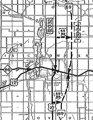
 Coldwater |
Southern Terminus: | I-69 at Exit 10 (Fenn Rd interchange) southeast of Coldwater | |||||||||||||
| Northern Terminus: | I-69 at Exit 13 (US-12 interchange) east of downtown Coldwater | ||||||||||||||
| Length: | 5.275 miles | ||||||||||||||
| Map: | Route Map of BL I-69 (Coldwater) | ||||||||||||||
| Notes: | A portion of BL I-69 runs along the former routing of US-27 prior to the completion of the I-69/US-27 freeway. | ||||||||||||||
 |
|||||||||||||||
| History: | 1967 (Nov 5) – The new I-69/US-27 freeway through Branch Co and bypassing the City of Coldwater to the east is completed and opened to traffic. While the former route of US-27 from the Indiana state line northerly to Fenn Rd and from US-12/Chicago St in downtown Coldwater northerly to the Branch/Calhoun Co line is also turned back to local control on this day, the portion from Fenn Rd to US-12 is redesignated as part of a new BL I-69 routing. Fenn Rd from the new freeway at Exit 10 westerly to the former route of US-27 along Angola Rd is transferred to state control to bring BL I-69 back to the freeway on the southern end. In Coldwater, US-12/Chicago St from Division St easterly to the new freeway at Exit 13 is signed concurrently with BL I-69 to bring the loop back to I-69/US-27 on the northern end. | ||||||||||||||
| Freeway/Expwy: | No portion of BL I-69 (Coldwater) is freeway or expressway. | ||||||||||||||
| NHS: | The entirety of BL I-69 (Coldwater) is on the National Highway System (NHS). (The route was added to the NHS in 2012 with the passage of the MAP-21 funding and authorization bill.) | ||||||||||||||
| Photographs: | |||||||||||||||
| Weblinks: | |||||||||||||||
Charlotte |
Southern Terminus: | I-69 at Exit 57 south of Charlotte | |||||||||||||
| Northern Terminus: | I-69 at Exit 61 northeast of downtown Charlotte | ||||||||||||||
| Length: | 4.890 miles | ||||||||||||||
| Map: | Route Map of BL I-69 (Charlotte) | ||||||||||||||
| Notes: | BL I-69 through Charlotte was originally, as one would suspect, the routing of US-27 through the city. In 1961, US-27 bypassed Charlotte, and the route became BUS US-27. For three years after I-69 was completed around Charlotte, the business routing through town remained BUS US-27, until 1974 when it was supplanted by BL I-69. | ||||||||||||||
| The history section for this route (below) also includes the history of its predecessor route, BUS US-27. | |||||||||||||||
| History: | 1961 (Dec 11) – The original two-lane US-27 bypass of Charlotte is completed and assumed into the state trunkline system from the existing route of US-27/Cochran Rd three miles south of downtown northeasterly and northerly back to existing US-27/Lansing Rd 1.25 miles northeast of downtown. The former route of US-27 through Charlotte via Cochran Rd/Ave, Lawrence Ave and Lansing Rd is designated BUS US-27. | ||||||||||||||
| 1970 (Aug 24) – The new I-69/US-27 freeway is completed from south of the Jackson/Eaton Co line northeasterly past Olivet to the south end of the 1961 US-27 two-lane bypass of Charlotte, which itself is converted to full freeway and designated as part of I-69/US-27 as well. BUS US-27 remains as the signed loop route through the city, though. | |||||||||||||||
| 1974 – BUS US-27 at Charlotte is redesignated in its entirety as BL I-69. | |||||||||||||||
| Freeway/Expwy: | No portion of BL I-69 (Charlotte) is freeway or expressway. | ||||||||||||||
| NHS: | The entirety of BL I-69 (Charlotte) is on the National Highway System (NHS). (The route was added to the NHS in 2012 with the passage of the MAP-21 funding and authorization bill.) | ||||||||||||||
| Photographs: | |||||||||||||||
| Weblinks: | |||||||||||||||
Lansing |
Western Terminus: | I-96/I-69 at Exit 93 west of Lansing | |||||||||||||
| Eastern Terminus: | I-69 at Exit 94 northeast of East Lansing | ||||||||||||||
| Length: | 14.616 miles | ||||||||||||||
| Map: | Route Map of BL I-69 (Lansing) | ||||||||||||||
| Notes: | BL I-69 at Lansing runs via Saginaw St/Hwy for nearly its entire length, with the primary exception of westbound traffic using Grand River Ave & Oakland St through the city itself (eastbound traffic remains on Saginaw St). BL I-69 is also concurrently signed with M-43 from I-96/I-69 easterly to the cnr of Grand River Ave & Saginaw St just east of US-127 on the Lansing/East Lansing boundary. | ||||||||||||||
| The portion of BL I-69 from US-127 through East Lansing to the intersection of Old M-78 was formerly a portion of TEMP I-69, and before that, M-78. | |||||||||||||||
| Lansing's BL I-69 routing is the longest "Business Connection" in the state, beating out Battle Creek's BL I-94 by 0.363 mile and Lansing's BL I-96 (which BL I-69 intersects) by 1.021 mile. | |||||||||||||||
| History: | 1987 (Nov 23, 10am) |
||||||||||||||
| 1988 (July 1) |
|||||||||||||||
| Freeway: | No portion of BL I-69 (Lansing) is freeway. | ||||||||||||||
| Expressway: | The easternmost ½ mile (approximately) of the route, from the Old M-78 intersection northerly to I-69 at Exit 94, is a limited-access expressway. | ||||||||||||||
| NHS: | The entirety of BL I-69 (Lansing) is on the National Highway System (NHS). | ||||||||||||||
| NHS: | Entire route. | ||||||||||||||
| Photographs: | |||||||||||||||
| Weblinks: | |||||||||||||||
Port Huron |
Western Terminus: | Jct I-69 & I-94 (at I-69 Exit 199) west of Port Huron | |||||||||||||
| Eastern Terminus: | I-69/I-94 at Exit 275 north of downtown Port Huron (at the foot of the Blue Water Bridge) | ||||||||||||||
| Length: | 6.178 miles | ||||||||||||||
| Map: | Route Map of BL I-69 (Port Huron) | ||||||||||||||
| Notes: | The portion of BL I-69 between the western terminus and jct BL I-94 was formerly M-21 before the I-69 designation was extended easterly from Flint in 1984. | ||||||||||||||
| When first designated, BL I-69 was signed as BS I-69 and ended at Gratiot Ave (then M-25) south of downtown. When M-25 was scaled back to its present terminus north of downtown and BL I-94 routed through town, BS I-69 became BL I-69 when it was extended concurrently with BL I-94 back to I-94/I-69. | |||||||||||||||
| The history section for this route (below) also includes the history of its predecessor route, BS I-69. | |||||||||||||||
| History: | 1984 (Dec) – With the completion of the "M-21 freeway" from Lapeer to west of Whadams and its redesignation as an extension of I-69 from Flint to Port Huron, the portion of the former M-21 from I-94 west of Port Huron at Exit 271 easterly to M-21/Huron St downtown is redesignated as BS I-69. This includes the short freeway segment of what had been designated M-21 between I-94 and just west of 24th St as well as the one-way pair of Oak St (ebd) and Griswold St (wbd). | ||||||||||||||
| 1986-87 – All of M-25 in the Port Huron & Marysville area is redesignated as BL I-94 and at the same time, BS I-69 is redesignated from a spur route into a full loop by extending it concurrently with the new BL I-94 northerly via Huron St and Pine Grove Ave, terminating with BL I-94 at I-94/I-69 at the foot of the Blue Water Bridge. | |||||||||||||||
| Freeway: | Between western terminus and 32nd St west of Port Huron. | ||||||||||||||
| Expressway: | The BL I-94/BL I-69 "connector" from the end of I-94/I-69 at the foot of the Blue Water Bridge to Pine Grove Ave. | ||||||||||||||
| NHS: | The entirety of BL I-69 (Port Huron) is on the National Highway System (NHS). | ||||||||||||||
| NHS: | Entire route. | ||||||||||||||
| Photographs: | |||||||||||||||
| Weblinks: | • BL I-69 (Port Huron) @ Michigan Highway Ends – photos of the termini of BL I-69 (Port Huron) at Dan Garnell's archived Michigan Highway Ends website. | ||||||||||||||
 Pontiac |
Southern Terminus: | I-75/Walter P Chrysler Frwy at Exit 75 in Auburn Hills southeast of Pontiac | |||||||||||||
| Northern Terminus: | I-75 at Exit 81 (at jct I-75 & M-24) in Auburn Hills northeast of Pontiac | ||||||||||||||
| Length: | 10.760 miles | ||||||||||||||
| Map: | |||||||||||||||
| Notes: | |||||||||||||||
| History: | 1963 (Dec 31) – The I-75/Walter P Chrysler Frwy bypass of Pontiac is completed and established as astate trunkline route from M-24 (present-day Exit 81) southerly past Pontiac and on toward Detroit, effectively replacing the easterly M-24 bypass of the city via Opdyke & Square Lake Rds, which are transferred to local control. Since M-24 is then truncated at the I-75 interchange (Exit 81), much of the former BUS M-24 through downtown Pontiac is redesignated as a new BL I-75 routing. Beginning at Exit 75, BL I-75 runs southwesterly as a short freeway segment to a "T" intersection with Square Lake Rd just east of Opdyke and Square Lake between this intersection and Opdyke Rd is transferred to state control as part of BL I-75. The route continues westerly via Square Lake Rd from Opdyke to US-10/Woodward Ave, replacing the former M-24 designation here. BL I-75 then turns northerly via Woodward supplanting the BUS M-24 designation and running concurrently with BUS US-10 into downtown, veering northerly onto Parke St and Perry Ave through downtown then northeasterly to the I-75 & M-24 jct northeast of the city. | ||||||||||||||
| 1964 (Nov 30) – In a major overhaul to downtown Pontiac, several downtown streets are closed and a new traffic "loop" completely encircling the downtown core is built, assumed as a state trunkline and opened to traffic, removing all north-south through traffic from the downtown area. The new loop, christened "Wide Track Drive" after the popular tagline for the Pontiac automobiles of the General Motors stable, begins at Woodward Ave at the cnr of Osmun Ave and continues northerly via what was previously known as Parke St to Perry Ave, then continues mostly on new alignment around the east and north sides of downtown to Cass Ave. From Cass, Wide Track Dr continues southeasterly paralleling the Grand Trunk Western tracks back to Woodward Ave, thus completing the loop around downtown. At the same time, Cass Ave from Oakland Ave northwest of downtown to Wide Track Dr is transferred to state control. All of Wide Track Dr becomes part of the BL I-75 route, with nbd BL I-75 occupying the eastern section from Woodward Ave south of downtown to Perry Ave northeast of downtown and sbd BL I-75 running along the northern and western sections from Perry Ave counterclockwise back to Woodward Ave south of downtown. The former BL I-75 route in downtown via Perry Ave from Wide Track near the cnr of Auburn Rd to Water St is abandoned as a public street, while the portion of Perry from Water to Wide Track a block north of Lafayette is turned back to local control. | |||||||||||||||
| 1966 (Nov 15) – A new interchange is built for BL I-75 at Opdyke Rd southeast of Pontiac instead of having the route ⊤ into Square Lake before proceeding westerly. From the east, BL I-75 now passes over Opdyke Rd (with ramps for access) and curves westerly, merging into and becoming Square Lake Rd. Existing Square Lake from the east now ends at a ⊤-intersection of its own at Opdyke Rd. | |||||||||||||||
| 2000 (Sept 5) – Wide Track Drive in downtown Pontiac is renamed, in its entirety, to Woodward Ave. This reflects both the City of Pontiac's desire to tap into the "Woodward Reniassance" taking place up and down that historic thoroughfare, as well as reflecting the realization that GM's Pontiac division is no longer headquartered in Pontiac and while GM does still manufacture vehicles within the city, Pontiacs themselves are no longer made in Pontiac. | |||||||||||||||
| 2010 (Oct 31) |
|||||||||||||||
| 2025–27 |
|||||||||||||||
| Freeway: | From southern terminus at I-75 (Exit 75) to Opdyke Rd interchange southeast of Pontiac. | ||||||||||||||
| NHS: | The entirety of BL I-75 (Pontiac) is on the National Highway System (NHS). (The portion of the route from BUS US-24/M-59/Woodward Ave downtown to Walton Blvd northeast of downtown was added to the NHS in 2012 with the passage of the MAP-21 funding and authorization bill.) | ||||||||||||||
| Photographs: | |||||||||||||||
| Weblinks: | • |
||||||||||||||
 Bay City |
Western Terminus: | I-75/US-23 at Exit 162 (at jct US-10 & M-25), three miles west of downtown Bay City | |||||||||||||
| Eastern Terminus: | Downtown Bay City at jct M-25 & M-84 (cnr McKinley St & Washington Ave for eastbound traffic; cnr 7th St & Washington Ave for westbound traffic) | ||||||||||||||
| Length: | 3.046 miles | ||||||||||||||
| Map: | Route Map of BS I-75 (Bay City) | ||||||||||||||
| Notes: | Business Spur I-75 was once Business Loop I-75 continuing southerly from its present-day eastern terminus via M-84 back to I-75 at Exit 160. When the route was scaled back from Exit 160 to end in downtown, M-84 was extended northerly to replace the former BL I-75 designation to that point. Since that time, BS I-75 has been 100 percent concurrently designated with M-25—and somewhat suprising, considering MDOT's distaste for concurrently-designated routes... | ||||||||||||||
| While BS I-75 signs are posted along the entire 3-mile route, there are no signs on I-75/US-23 itself pointing to "BS I-75," only to M-25. | |||||||||||||||
| The history section for this route (below) also includes the history of its predecessor route, BL I-75. | |||||||||||||||
| History: | 1961 (Jan 3) – The segment of I-75/US-10/US-23 and US-23 freeway from Saginaw northerly past Bay City to Kawkawlin is assumed into the state trunkline system and likely opens at this same time. The US-23 designation is moved to this new freeway and several other route designation changes also take place in the Bay City area. While M-13 is extended northerly from Saginaw to take the former route of US-23 through Bay City to Kawkawlin, M-47 north of Saginaw is removed from its Bay City alignment and moved to one running via Freeland toward Midland. Thus, from Exit 160 on the new freeway southwest of Bay City, a new BL I-75 designation replaces M-47 northeasterly into Bay City. (M-84 is assigned to the former M-47 from I-75/US-10/US-23 southerly into Saginaw.) BL I-75 then leaves the former route of M-47 (which continues northerly along Euclid Ave, now designated M-13) and heads easterly co-signed with M-13 via Salzburg Ave, the Lafayette Bridge and Kosciuszko Ave along what was previously US-23 to Garfield Ave. Here, BL I-75 replaces the former BUS US-23 via Garfield Ave, Columbus Ave and Washington Ave into downtown. The new BL I-75 continues westerly, still supplanting BUS US-23 but now co-signed with M-15/M-25 via 7th St (wbd) and McKinley St (ebd), the Veterans Memorial Bridge, and Jenny St (wbd) and Thomas St (wbd) to Euclid Ave (formerly US-23/M-47, now M-13) where M-15 formerly terminated. BL I-75 continues westerly with M-15/M-25 via Jenny & Thomas Sts and the freeway connector to jct I-75/US-23 and US-10 west of Bay City, where BL I-75, M-15 and M-25 all terminate at present-day Exit 162. | ||||||||||||||
| 1970 – The concurrent M-15 designation along BL I-75/M-25 from downtown Bay City westerly to I-75/US-10/US-23 is removed from the route. | |||||||||||||||
| 1971 – BL I-75 loses more than half of its length when the highway is truncated in downtown Bay City, converting the Business Loop into a Business Spur, designated BS I-75. The portion of the former BL I-75 from I-75/US-10/US-23 at Exit 160 southwest of the city northeasterly via Saginaw Rd, Salzburg Ave, Lafayette Bridge, Kosciuszko Ave, Garfield Ave, and Washington Ave is redesignated as a northerly extension of M-84. BS I-75 now terminates at cnr of McKinley St & Washington Ave (ebd) and 7th St & Washington Ave (wbd), while still running concurrently with M-25 for its entire length between there and its western terminus. | |||||||||||||||
| Freeway: | From BL I-75 western terminus to approximately 1 mile east of the western terminus. | ||||||||||||||
| NHS: | The entirety of BS I-75 (Bay City) is on the National Highway System (NHS). | ||||||||||||||
| Circle Tour: | |||||||||||||||
| Photograph: | • |
||||||||||||||
| Weblinks: | • BS I-75 (Bay City) @ Michigan Highway Ends – photos of the termini of BS I-75 (Bay City) at Dan Garnell's archived Michigan Highway Ends website. | ||||||||||||||
West Branch |
Southern Terminus: | I-75 at Exit 212 (Cook Rd interchange) south of West Branch | |||||||||||||
| Northern Terminus: | I-75/M-55 at Exit 215 (M-55 EAST interchange) west of West Branch | ||||||||||||||
| Length: | 5.525 miles | ||||||||||||||
| Map: | Route Map of BL I-75 (West Branch) | ||||||||||||||
| Notes: | BL I-75 at West Branch began as BUS M-76 with the completion of a portion of the M-76 freeway around town in the early 1970s. While much of BUS M-76 (and today's BL I-75) used the former route of M-76 through West Branch, the portion from Cook Rd to Alger Rd/Old M-76 was actually built on new alignment. | ||||||||||||||
| The history section for this route (below) also includes the history of its predecessor route, BUS M-76. | |||||||||||||||
| History: | 1970 – The new M-76 freeway (present-day I-75) is completed from Alger in northwest Arenac Co to Cook Rd just south of West Branch. A new state trunkline alignment is constructed and assumed into the system from the end of the new freeway at Cook Rd northerly to existing M-76 southeast of West Branch. M-76 then continues via its existing routing to M-55, then westerly with M-55 through downtown West Branch and on toward St. Helen. | ||||||||||||||
| 1971 – The portion of the M-76 freeway (present-day I-75) bypassing West Branch to the southwest from Cook Rd northwesterly to M-55 is completed and opened to traffic. The former route of M-76 from the freeway south of town northerly to M-55 on the east city limit, then westerly through downtown to the end of the new freeway west of the city is redesignated as BUS M-76. This BUS M-76 routing is the direct predecessor of present-day BL I-75. | |||||||||||||||
| 1973 – The final segment of the M-76 freeway is completed from M-55 west of West Branch to M-18 south of Roscommon and the entire route of M-76 is assumed into the route of I-75, thus completing the entire length of I-75 in Michigan. Since its parent route is decommissioned, BUS M-76 is redesignated as BL I-75. | |||||||||||||||
| Freeway/Expwy: | No portion of BL I-75 (West Branch) is freeway or expressway. | ||||||||||||||
| Photographs: | |||||||||||||||
| Weblinks: | |||||||||||||||
Roscom- mon | Southern Terminus: | I-75 at Exit 239 (M-18 interchange) south of Roscommon | |||||||||||||
| Northern Terminus: | I-75 at Exit 244 west of Roscommon | ||||||||||||||
| Length: | 7.003 miles | ||||||||||||||
| Map: | Route Map of BL I-75 (Roscommon) | ||||||||||||||
| Notes: | This route is concurrently signed with M-18 between I-75 south of the village and downtown Roscommon. From that point westerly back to I-75, BL I-75 replaced a concurrent M-18/M-76 routing. M-18 was then rerouted to the northeast of Roscommon, replacing the M-144 designation in its entirety. | ||||||||||||||
| History: | 1973 – The final segment of the M-76 freeway is completed from M-55 west of West Branch to M-18 south of Roscommon at the southern end of the existing freeway there. The entire route of M-76 is assumed into the route of I-75, thus completing the entire length of I-75 in Michigan. A new BL I-75 designation is commissioned at Roscommon, beginning at I-75 south of town (at present-day Exit 239) and running northerly with M-18 into downtown. There, the new BL I-75 turns westerly to follow what had been designated M-18/M-76 (M-18 now continues northeasterly from Roscommon via the former route of M-144) to I-75 west of town at present-day exit 244. | ||||||||||||||
| Freeway/Expwy: | No portion of BL I-75 (Roscommon) is freeway or expressway. | ||||||||||||||
| Photographs: | |||||||||||||||
| Weblinks: | • BL I-75 (Roscommon) @ Michigan Highway Ends – photos of the termini of BL I-75 (Roscommon) at Dan Garnell's archived Michigan Highway Ends website. | ||||||||||||||
Grayling |
Southern Terminus: | I-75 at Exit 254 south of Grayling | |||||||||||||
| Northern Terminus: | I-75 at Exit 259 (M-93 interchange) north of Grayling | ||||||||||||||
| Length: | 6.173 miles | ||||||||||||||
| Map: | Route Map of BL I-75 (Grayling) | ||||||||||||||
| Notes: | Concurrently designated with M-72 through downtown Grayling (between Huron St–South Down River Rd and Lake St-Kalkaska Rd) and concurrent with M-93 from the northern M-72 junction to BL I-75's nothern terminus. | ||||||||||||||
| Much of BL I-75 through Grayling is routed over the original route of US-27 through the city. | |||||||||||||||
| History: | 1961 (Dec 4) – All of I-75 from the " US-27 Split" south of Grayling to the Crawford/Otsego Co line is officially assumed into the state trunkline system and likely opens near this same time. While the former route of US-27—which I-75 replaces—from Grayling southerly to 5 Mile Rd is largely obliterated by the new I-75 freeway, the portion of old US-27 from M-93/Hartwick Pines Rd northerly to the Crawford/Otsego Co line is turned back to local control on this date. A new BL I-75 routing is then commissioned through downtown Grayling. Beginning at present-day Exit 254 south of the city, the new BL I-75 continues northerly via the former route of US-27 to M-72/Huron St, then turns northwesterly via Cedar St concurrently with M-72 to the cnr of Cedar St, McClellan St & Lake St where M-72 turns westerly and M-93 joins. BL I-75 then runs northerly with M-93 to Hartwick Pines Rd, then northeasterly via M-93/Hartwick Pines Rd, terminating at I-75 north of the city at Exit 259. | ||||||||||||||
| Freeway/Expwy: | No portion of BL I-75 (Grayling) is freeway or expressway. | ||||||||||||||
| NHS: | BL I-75 (Grayling) from the southern terminus at I-75 Exit 254 to the northern jct with M-72 (and M-93) north of downtown is on the National Highway System (NHS). | ||||||||||||||
| Photographs: | |||||||||||||||
| Weblinks: | • BL I-75 (Grayling) @ Michigan Highway Ends – photos of the termini of BL I-75 (Grayling) at Dan Garnell's archived Michigan Highway Ends website. | ||||||||||||||
| • |
|||||||||||||||
Gaylord |
Southern Terminus: | I-75 at Exit 279 (Old 27 interchange) south of Gaylord | |||||||||||||
| Northern Terminus: | I-75 at Exit 282 (M-32 interchange) west of downtown Gaylord | ||||||||||||||
| Length: | 3.558 miles | ||||||||||||||
| Map: | Route Map of BL I-75 (Gaylord) | ||||||||||||||
| Notes: | |||||||||||||||
| History: | 1962 (July 20) – The former route of US-27 from downtown Gaylord at M-32 southerly toward Otsego Lake is turned cck to local control after the new I-75 freeway is completed and opened to traffic. Upon the freeway's completion, a Business Connection routing is not initially established at Gaylord. | ||||||||||||||
| 1986 (Apr 15) – The 3.24-mile segment of Old 27 and S Otsego Ave between I-75 at Exit 279 south of Gaylord northerly to M-32/Main St in downtown Gaylord is officially (re-)established as a state trunkline route as part of the establishment of a BL I-75 route through Gaylord. (This segment of highway was part of a portion of US-27 cancelled as a trunkline route and turned back to local control in July 1962 with the coming of the I-75 freeway in the area.) From downtown Gaylord, the new BL I-75 is signed concurrently with M-32 along W Main St back to I-75 at Exit 282 on the west side of town. | |||||||||||||||
| Freeway/Expwy: | No portion of BL I-75 (Gaylord) is freeway or expressway. | ||||||||||||||
| NHS: | The entirety of BL I-75 (Gaylord) is on the National Highway System (NHS). (The portion of the route from the southern terminus at I-75 Exit 279 to M-32 downtown was added to the NHS in 2012 with the passage of the MAP-21 funding and authorization bill.) | ||||||||||||||
| Photographs: | |||||||||||||||
| Weblinks: | |||||||||||||||
Saint Ignace |
Southern Terminus: | I-75 at Exit 344 (US-2 WEST interchange) southwest of downtown | |||||||||||||
| Northern Terminus: | I-75 at Exit 348 (H-63/Mackinac Trail interchange) north of St Ignace | ||||||||||||||
| Length: | 4.719 miles | ||||||||||||||
| Map: | Route Map of BL I-75 (St Ignace) | ||||||||||||||
| Notes: | BL I-75 follows the former route of US-2 through St Ignace. | ||||||||||||||
| History: | 1960 – Although the portion of the I-75/US-2 freeway bypassing Saint Ignace to the west wouldn't be officially established as a state trunkline highway until the end of 1963 (reason unknown), the freeway itself from the north end of the Mackinac Bridge approach at US-2 on the south side of Saint Ignace northerly to to the southern end of an existing freeway segment at Castle Rock (present-day Exit 348) is completed and opened to traffic as I-75/US-2. The former route of US-2 through downtown Saint Ignace is redesignated as BL I-75. | ||||||||||||||
| 1963 (Dec 5) – As noted above, the I-75/US-2 freeway from the US-2 West interchange (Exit 344) on the south side of Saint Ignace northerly is officially established as a state trunkline highway... although the highway has been open for three years at this point! No change occurs to the route of BL I-75, however. | |||||||||||||||
| 2017 (Oct 6) – US-2 from Manistique to St Ignace in Schoolcraft and Mackinac Counties and all of BL I-75 at St Ignace is officially designated as the Top-of-the-Lake Pure Michigan Byway and the official dedication ceremony for the byway is held at the Top of the Lake Snowmobile Museum in Naubinway. Representatives from the Michigan Department of Transportation, Eastern U.P. Regional Planning & Development Commission, Travel Michigan and other organizations are in attendance. | |||||||||||||||
| Freeway/Expwy: | No portion of BL I-75 (St Ignace) is freeway or expressway. | ||||||||||||||
| NHS: | The portion of BL I-75 from the southern terminus to the Mackinac Island Ferry Docks in downtown St Ignace is a NHS Intermodal Connector. | ||||||||||||||
| Pure Michigan Byway: | |||||||||||||||
| Circle Tour: | |||||||||||||||
| Photographs: | |||||||||||||||
| Weblinks: | • BL I-75 (St Ignace) @ Michigan Highway Ends – photos of the termini of BL I-75 (St Ignace) at Dan Garnell's archived Michigan Highway Ends website. | ||||||||||||||
| • Mackinac Straits Historical Photos – a collection of photos from the 1950s with scenes during and just after construction of the Mackinac Bridge. | |||||||||||||||
Sault Ste Marie |
South/Western Terminus: |
I-75 at Exit 392 (3 Mile Rd interchange) on the southern Sault Ste Marie city limit | |||||||||||||
| North/Eastern Terminus: |
Sugar Island Ferry dock east of downtown Sault Ste Marie | ||||||||||||||
| Length: | 5.902 miles | ||||||||||||||
| Map: | Route Map of BS I-75 (Sault Ste Marie) | ||||||||||||||
| Notes: | It remains somewhat unclear whether BS I-75 at Sault Ste Marie was ever designated and signed as a Business Loop through the city or not. It seems the portion of Easterday Ave from I-75 at Exit 394 easterly to Ashmun Ave was once a state trunkline highway in the 1980s and several commercial maps from the 80s and 90s indicate this portion of Easterday as part of a Business Loop I-75 routing. Several site visitors, however, have stated they never recall seeing any BL I-75 route markers posted along Easterday Ave, leading one to believe Easterday was an unsigned trunkline for several years before being transferred back to local control. See the "History" section below for more details. | ||||||||||||||
| The "South/Western Terminus" and "North/Eastern Terminus" listings above are to denote that while the highway originated as a north-south route, over the years it has been extended more to the east so that it first runs east-west, then northeast-southwest before becoming north-south and finally turning east-west again to its terminus at the Sugar Island Ferry Dock. | |||||||||||||||
| History: | 1962 (Oct 31) – The new International Bridge linking Sault Ste Marie, Michigan with Sault Ste Marie, Ontario opens to traffic. | ||||||||||||||
| 1962 (Nov 5) – The new freeway connection and bridge approach roadway on the Michigan side of the bridge are established as a state trunkline route, although it can be assumed at least some portion of the highway was open six days earlier when the International Bridge officially opened to traffic. The new freeway segment, designated I-75/US-2, begins at Three Mile Rd on the south limits of Sault Ste Marie and continues northerly past Easterday Ave connecting in with the new International Bridge north of there. To connect the new freeway segment to existing US-2, Three Mile Rd from US-2/Mackinac Trail westerly to the freeway is transferred to state control. Simultaneously, a new BS I-75 designation is commissioned at the Sault, beginning at the southern end of this segment of I-75 and running easterly via US-2/Three Mile Rd to the former US-2, then turning northeasterly supplanting the former US-2 route via Mackinac Trail (now "I-75 Business Spur") and northerly via Ashmun St into downtown where it terminates at Portage Ave. (Previously US-2 had continued one block further north via Ashmun then easterly three blocks via Water St to the now-former automobile ferry dock, however this 4/10-mile segment is turned back to local control on this date.) | |||||||||||||||
| 1963 (Dec 5) – A segment of I-75/US-2 freeway is completed and established as a state trunkline route connecting completed portions of the route between Mackinac Trail at Dafter and Three Mile Rd at Sault Ste Marie. Thus, the US-2 designation co-signed with BS I-75 along Three Mile Rd between I-75 and Mackinac Trail is removed | |||||||||||||||
| 1981 (Aug 7) |
|||||||||||||||
| 1983 (Nov 16) |
|||||||||||||||
| 1989 (Mar 3) – The Sault's BS I-75 route is extended easterly from downtown when the 2.6-mile portion of Portage Ave from Ashmun St to the Sugar Island Ferry Dock access road is established as a state trunkline route and transferred from city of state control. | |||||||||||||||
| 199__ – At some point during the 1990s, the approximately one mile segment of Easterday Ave from I-75 to BS I-75/Ashmun St is transferred back to local control. Unfortunately, this precise date is not yet clear. | |||||||||||||||
| Freeway/Expwy: | No portion of BS I-75 (Sault Ste Marie) is freeway or expressway. | ||||||||||||||
| Circle Tour: | |||||||||||||||
| Photographs: | |||||||||||||||
| Weblinks: | • BS I-75 (Sault Ste Marie) @ Michigan Highway Ends – photos of the termini of BS I-75 (Sault Ste Marie) at Dan Garnell's archived Michigan Highway Ends website. | ||||||||||||||
| • I-75 BR (Ashmun St.)/Power Canal Bridge – archived from MDOT: "This is one of only three steel arch bridges in Michigan and is a massive structure, measuring 42 feet wide and 257 feet in length." | |||||||||||||||
 Benton Harbor- St Joseph |
Western Terminus: | I-94 at Exit 23 just north of Stevensville (south of Saint Joseph) | |||||||||||||
| Eastern Terminus: | I-94 at jct I-94 & US-31 at Exit 33A-B (US-31 nbd Exit 27) east of Benton Harbor | ||||||||||||||
| Length: | 10.848 miles | ||||||||||||||
| Map: | Route Map of BL I-94 (Benton Harbor-St Joseph) | ||||||||||||||
| Notes: | Much like BL I-94's eastern entrance into Benton Harbor from I-94/US-31 east of the city, a similar southern entrance for this route was long planned from even before I-94 was I-94, back when it was part of the US-12 "Detroit-Chicago Expressway" in the 1950s. Property was acquired in the 1960s to build the new "Penetrator" route, but work never began and the right-of-way was sold off decades later. This expressway route into the south side of St Joseph would have replaced the current route of BL I-94 via Lake Shore Dr, beginning at I-94 between Washington Ave and Lincoln Ave and continuing generally northerly to US-33 (present-day M-63), then northerly via US-33 into downtown St Joseph. | ||||||||||||||
| The eastern portion of BL I-94, sometimes called the "Benton Harbor Penetrator" (to differentiate between the proposed, but never constructed, St Joseph Penetrator route south of that city), which runs adjacent to E Main St and is effectively an easterly extension of E Main St from downtown Benton Harbor, was greatly altered during hte 2020–21 construction seasons in conjunction with buildling the final segment of the US-31 freeway in Berrien County. The easternmost 1¾ mile of BL I-94 from approximatey Urbandale Ave on the eastern edge of Benton Harbor easterly to the original I-94/US-31 Exit 33 interchange was originally constructed as a four-lane divided, limited-access expressway with a "faux interchange" at Crystal Ave (on- and off-ramps, but Crystal Ave still intersected BL I-94 at-grade without a grade separation [overpass/underpass]) and a grade-separation at Euclid Ave. As with other portions of BL I-94 in Benton Harbor—where MDOT reduced the number of lanes from five lanes to three lanes, as well as removed traffic signals and installed roundabouts—MDOT decided to perform a so-called "right-sizing" on the limited-access section of roadway. The "faux interchange" at Crystal Ave had its four on- and off-ramps removed and was replaced by a roundabout, while the limited-access portion in its entirety was reduced from a four-lane divided expressway to a two-lane unvided expressway, with the former westbound lanes being reconstructed as the new highway alignment and the former eastbound lanes oblibterated, between Urbandale Ave and approx 750 feet east of the Euclid Ave overpass. From that point, BL I-94 now turns east-southeasterly along a new alignment to intersect I-94 at almost the exame exact location as the former Highland Ave overpass, which was removed. A 'parclo' interchange (partial cloverleaf) was constructed at I-94 where it now meets the extended US-31 freeway, which is now the terminus of BL I-94. | |||||||||||||||
| Prior to the relocation of the eastermost end of BL I-94 in 2021-22, the overall length of the route was 11.417 miles. With the changes, which were largely completed in late 2021 (with respect to the BL I-94 portion of the project), the length of BL I-94 at Benton Harbor-St Joseph is now 10.848 miles long, for a net loss of 0.569 mile in the length of the route. Two other state trunkline routes leap-frogged over this route with this change: both M-93 (10.991 miles) and unsigned OLD I-69 in Clinton–Shiawassee Cos (10.890 miles) are now longer than BL I-94. | |||||||||||||||
| History: | 1960 (Nov 17) – While the route of the I-94/US-12 freeway bypassing the twin cities of St Joseph and Benton Harbor would not be officially assumed into the state trunkline highway system until June 1962 (reason unknown), sources point to November 17, 1960 as the likely completion date of this segment of freeway, from present-day Exit 23 northeasterly past Watervliet. Thus, much of the former route of US-12 through the downtowns of both cities is redesignated as a new BL I-94 routing. Beginning at the temporary western end of the freeway just north of Stevensville, the new BL I-94 proceeds north-northeasterly via the former US-12 along Lake Shore Dr into St Joseph at Lakeview Ave, then northeasterly via Main St to Ship St, easterly three blocks on Ship, then northeasterly via Wayne St across the St Joseph River and into Benton Harbor. There, BL I-94 follows Main St through the city to M-139/Fair Ave. From Fair Ave easterly to the new I-94/US-12 freeway, the new BL I-94 follows an upgraded version of Main St, although this segment of highway will not be officially transferred to state control until June 1962, the same time the rest of I-94 is officially assumed as well. | ||||||||||||||
| 1962 (July 20) – On this day, all of I-94 from US-12 at New Buffalo to the Berrien/Van Buren Co line is officially assumed into the state trunkline system, although half of this segment had been completed in 1960 with the remainder opening in 1961. In addition, the upgraded portion of Main St from M-139/Fair Ave to I-94 just east of Benton Harbor is also officially assumed into the system on this day as well, although it too has been open for more than a year-and-a-half at this point. It remains unclear why the opening and establishment dates for these routes are not the same. | |||||||||||||||
| 1967 (Oct 10) – The three blocks of Port St from US-33/Main St easterly to Wayne St are transferred to state control and westbound BL I-94 traffic is now diverted to Port St westerly to US-33/Main St, then southerly one block via Main to existing BL I-94 at Ship St. Ship St from Main St easterly to Wayne St and Wayne from Ship northerly to Port becomes the eastbound route. | |||||||||||||||
| 1976 (June 16–Fall) |
|||||||||||||||
| 1976 (Nov 30)–1977 (Mar 31) |
|||||||||||||||
| 1977 (Sept 14) |
|||||||||||||||
| 1978 (June 8) |
|||||||||||||||
1986 (April 1)
|
|||||||||||||||
| 2010 (Late) – BL I-94/Main St through downtown Benton Harbor is "right-sized" by MDOT as part of a complete reconstruction project between River St (which is later closed off and vacated) on the west and Pine St–Martin Luther King Jr Dr (M-139 nbd) on the east. Formerly five lanes (two lanes each direction with a center left turn lane), this segment is reduced to one lane in each direction with a center left turn lane as well as adding a roundbout at Fifth St and replacing the traffic signal at Riverview Dr with a second roundabout (the traffic signals at Water St–Pipestone St and Colfax Ave intersections are retained, however). From Pine–MLKing easterly to the beginning of the divided expressway segment (approx 380 ft west of Urbandale Ave), the roadway is resurfaced and re-marked with one lane in each direction, a center left turn lane and bicycle lanes. Work is completed by the end of the construction season. |
|||||||||||||||
| 2016 (July 25) – The West Michigan Pike Historic Byway is officially unveiled at a ceremony in Muskegon's Heritage Park. Running from the Indiana state line south of New Buffalo up Michigan's west coast to Ludington, the Byway runs along the segment of BL I-94 from the southern terminus at I-94 at Exit 23 north of Stevensville to northern jct of M-63 in downtown St. Joseph. | |||||||||||||||
| 2016 (July 25) – The West Michigan Pike Historic Byway is officially unveiled at a ceremony in Muskegon's Heritage Park. Running from the Indiana state line south of New Buffalo up Michigan's west coast to Ludington, the Byway runs along the segment of BL I-94 from the southern terminus at I-94 at Exit 23 north of Stevensville to northern jct of M-63 in downtown St. Joseph. | |||||||||||||||
2020–22 – In conjunction with the construction to complete the final segment of the US-31 Freeway in Berrien County, the "right-sizing" of BL I-94 at Benton Harbor that was begun a decade earlier is continued to the easternmost segment of the route, from approx. 380 ft west of Urbandale Ave (where the route has transitioned into a four-lane, divided limited-access expressway) easterly to I-94/US-31 at Exit 33. The work progresses in stages over three construction seasons:
|
|||||||||||||||
| Freeway: | No portion of BL I-94 (Benton Harbor–St Joseph) is freeway. | ||||||||||||||
| Expressway: | From approx 380 ft west of Urbandale Ave on the east side of Benton Harbor easterly to the eastern terminus at I-94/US-31 s a two-lane, undivided limited-access expressway. | ||||||||||||||
| NHS: | The entirety of BL I-94 (Benton Harbor-St Joseph) is on the National Highway System (NHS). | ||||||||||||||
| Circle Tour: | |||||||||||||||
| Pure Michigan Byway: | |||||||||||||||
| Photographs: | |||||||||||||||
| Weblinks: | • I-94 Business Loop Design – Benton Harbor, MI – from Abonmarche, the firm who coordinated streetscape conceptual and final design, municipal and utility design per MDOT standards, and the public involvement process for the 2010 reconstruction of the 1¾ mile of BL I-94 through downtown Benton Harbor. | ||||||||||||||
 Kalamazoo |
Western Terminus: | Cnr King Hwy & Mills St in the eastern portion of Kalamazoo | |||||||||||||
| Eastern Terminus: | I-94 at Exit 81 east of Kalamazoo | ||||||||||||||
| Length: | 3.713 miles | ||||||||||||||
| Map: | Route Map of BS I-94 (Kalamazoo) | ||||||||||||||
| Notes: | In 2019, every through trunkline route in Kalamazoo—BL I-94, BUS US-131 and M-43—as well as the unsigned M-331 were all turned back to local control by MDOT after many, many years of discussion between City and MDOT planners and engineers. City staffers had long sought to eliminate what they termed as "confusing" one-way streets through the heart of downtown Kalamazoo as well as trying to limit or eliminate large trucks from traversing through the city. MDOT, on the other hand, had long stuck to its mandate to provide a smoothly-operating network of arteries, minimizing delays and congestion. The two sides could never come to a satisfactory solution so, in 2018, MDOT staff in Southwest Region finally gave up and acquiesced to the City's demands by agreeing to transfer all downtown trunkline highway routes to local control. As of January 14, 2019, the downtown trunklines became city streets. To retain "route connectivity," MDOT decided to reroute M-43 along US-131 from Kalamazoo to Plainwell, then southeasterly concurrently with M-89 to Richland where it meets back up with the existing route. Unfortunately, this left several "stub routes" terminating at random locations around the city. MDOT employed three different strategies to deal with this:
|
||||||||||||||
| Prior to its truncation due to the 2019 juridictional transfers, BL I-94 at Kalamazoo was concurrently designated with US-131 between I-94 and US-131 at Exit 36, then with BUS US-131 between US-131 and downtown Kalamazoo. The portion of the former BL I-94/BUS US-131 from US-131 at Exit 26 easterly along Stadium Dr to Rambling Rd in the City of Kalamazoo is now an unsigned state trunkline highway (assumedly) designated OLD BL I-94/BUS US-131. | |||||||||||||||
| Kalamazoo's BL I-94 was originally designated as BUS US-12, a loop off the US-12 "Detroit-Chicago Expressway," for a short time. The history section for this route (below) also includes the history of this predecessor route. | |||||||||||||||
| Prior to its truncation due to the 2019 juridictional transfers, BL I-94 at Kalamazoo was 11.238 miles in length. It is now 33.04% of its previous length. | |||||||||||||||
| History: | 1957 (June 24) – The first segment of the planned US-12 freeway bypass of Kalamazoo opens from existing US-12 east of the city (present-day I-94 Exit 81) southwesterly to US-131/Westnedge Ave south of the city, however since the bypass is not yet complete, it seems the new route is not posted as part of US-12 and through traffic is still routed through the city via the existing route of US-12 along King Hwy, Michigan Ave and Stadium Dr. | ||||||||||||||
| 1959 (Dec 7) – The remainder of the "Kalamazoo Bypass" is completed from US-131/Westnedge Ave westerly into Van Buren Co and signed as not only a relocation of US-12, but also part of the newly-designated I-94. The existing route of US-12 beginning at present-day Exit 81 and continuing westerly to King Hwy, then via King Hwy, Michigan Ave and Stadium Dr through Kalamazoo to Michigan Ave west of the city, then westerly via Michigan Ave (present-day Stadium Dr) to Oshtemo is redesignated as BUS US-12. To connect the new business route back to its parent route, US-12, 9th St from Michigan Ave (present-day Stadium Dr) in Oshtemo southerly to the new I-94/US-12 freeway is temporarily signed and maintained as part of BUS US-12. (The rest of US-12 along Michigan Ave and Red Arrow Hwy from Oshtemo westerly to the Kalamazoo/Van Buren Co line is turned back to local control on this date.) | |||||||||||||||
| 1960 (Jan 6) – The temporary segment of BUS US-12 along 9th St from Michigan Ave (present-day Stadium Dr) in Oshtemo southerly to I-94/US-12 is officially "established" as a marked-and-maintained route, although not officially transferred to state control. This route will revert back to full local control when a new business connection routing is established via the proposed US-131 freeway in the future. | |||||||||||||||
| 1960 – At some point in late 1960, the entire route of BUS US-12 at Kalamazoo is redesignated as BL I-94. This is likely done in preparation for the complete removal of US-12 from the I-94 corridor and its transfer to the US-112 alignment further south. | |||||||||||||||
| 1963 (Dec 16) – The US-131 freeway from M-43/W Main St west of Kalamazoo to Shaver Rd-Westnedge Ave between Schoolcraft and Portage is completed and officially assumed into the state trunkline system. Along with other state trunkline system changes in the Kalamazoo area, the route of BL I-94 is rerouted southerly along the new US-131 freeway from Stadium Dr southerly to I-94 at present-day Exit 74 southwest of the city. The former route of BL I-94 via Stadium Dr and Michigan Ave from the new US-131 freeway to 9th St in downtown Oshtemo is turned back to local control and 9th St between Michigan Ave and I-94 is no longer marked-and-maintained as a trunkline and full control reverts back to local control as well. | |||||||||||||||
| 1965 (Oct 4) – Several segments of streets in downtown Kalamazoo are transferred to state control in an effort to streamline traffic patters through the heart of the city. Kalamazoo Ave from Michigan Ave east of downtown to nbd BUS US-131/Park St becomes a state trunkline and a brand-new street, Michikal Ave—a connector between Michigan Ave and Kalamazoo Ave—is also made part of the system. Kalamazoo Ave from Michigan Ave to Michikal and Michikal from Kalamazoo to the cnr of Michigan Ave & W Main St is then signed as the westbound route of BL I-94 through the city, while the existing route via Michigan Ave between the cnr of W Main St & Michikal Ave and Kalamazoo Ave now serves eastbound only traffic. | |||||||||||||||
| 2000s–2010s – For many years, disagreement about the proper function of the major thoroughfares through downtown Kalamazoo, the most major of which were state trunkline highway routes, existed between City planners and engineers and the planners and engineering staffs at the MDOT regional office. Several attempts were made to find common ground with little to no success. A push in the mid- to late-2010s resulted in City staff members making headway while MDOT staff grew tired of the impass, resulting in the state agreeing to simply turn back all downtown Kalamazoo state highway routes to the City. | |||||||||||||||
| 2019 (Jan 7–14) – After the Kalamazoo City Commission agrees to the Memorandum of Understanding from MDOT on the conditions of the trasfer of the affected streets in the city a week earlier on January 7, MDOT approves the changes on January 14, thereby removing them from the state trunkline highway system and transferring them to the city primary street system. For M-43, this affected the entire route from Douglas St west of downtown to the intersection of Riverview Dr & Gull Rd/Gull St northeast of dowtown, including the one-way pair of Michigan Ave (eastbound) and Kalamazoo Ave/Douglas St (westbound) through the heart of the city. | |||||||||||||||
| 2019 (June 3–7) – MDOT crews remove the state trunkline route markers from both the transferred roadways in dowtown Kalamazoo as well as along those segments which will remain as unsigned state trunkline routes. All BL I-94 signage along Stadium Dr, Michigan Ave, Michikal St, Kalamazoo Ave, and the portion of King Hwy west of Mills St is removed, while all BL I-94 signs from that point easterly to I-94 at Exit 81 are swapped out for BS I-94 (Business SPUR I-94) route markers. Additionally, all BL I-94 signage remains at US-131's Exit 36 on the west side of Kalamazoo. | |||||||||||||||
| Freeway: | None. | ||||||||||||||
| Expressway: | From jct M-96 at cnr King Hwy & Amvets Memorial Pkwy southeasterly to eastern terminus at I-94 Exit 81.) | ||||||||||||||
| NHS: | The entirety of BS I-94 (Kalamazoo) is on the National Highway System (NHS). | ||||||||||||||
| Photographs: | |||||||||||||||
| Weblinks: | |||||||||||||||
Battle Creek |
Western Terminus: | I-94 at Exit 92 (at jct I-94 & M-37/BL I-94) in southwestern Battle Creek (on the Kalamazoo/Calhoun Co line) | |||||||||||||
| Eastern Terminus: | I-94 at Exit 104 (at jct I-94 & BL I-94/M-311/M-96) east of Battle Creek | ||||||||||||||
| Length: | 14.253 miles | ||||||||||||||
| Map: | Route Map of BL I-94 (Battle Creek) | ||||||||||||||
| Notes: | Battle Creek's BL I-94 is an interesting route in that it not only runs concurrently with four other routes in the course of its 14.52-mile existence, but it meets up with one of those concurrent routes twice—and prior to jurisdictional transfers in May 2005, BL I-94 at Battle Creek even met up with a second concurrent route, twice! BL I-94 is also concurrently designated with other routes at each end of the highway as well, which is an odddity in terms of route designations in Michigan. On its western end, M-37 is co-signed with BL I-94 from its western terminus to the cnr of Dickman Rd & Helmer Rd, while M-96 joins with BL I-94 for a first time along Helmer Rd between Columbia Ave and Dickma Rd and again for a second time from the eastern end of Columbia Ave at E Michigan Ave easterly to the route's eastern terminus. In the middle, BL I-94 was formerly routed concurrently with I-194/M-66 for a short distance until 2008, although a 2009–10 realignment on BL I-94's eastern end resulted in adding a short concurrency with M-311. | ||||||||||||||
| A major rerouting for BL I-94 (and its concurrent partner designation, M-37) on the west side of Battle Creek occurred in 2015 when a segment of BL I-94/M-37 was removed as part of a project to accommodate expanding munitions storage at the adjacent Battle Creek Air National Guard Base. According to the Battle Creek Enquirer,"Battle Creek officials support the closure, saying it will create a joint base for the U.S. Army, Air National Guard and Navy that could boost Fort Custer Training Center's chances of being selected as a ballistic missile defense site." The portion of Skyline Dr/M L King Jr Dr from Columbia Ave northerly to Hill Brady Rd was transferred to the City of Battle Creek, while the portion between Hill Brady Rd and M-96/Dickman Rd was closed and obliterated. MDOT, meanwhile, took jurisdiction of Columbia Ave from Skyline/MLKing easterly to Helmer Rd (for a third time, the second time in 17 years!). The BL I-94/M-37 route now continues northeasterly and easterly from the intersection of Columbia Ave & Skyline/MLKing via Columbia Ave to Helmer Rd, then joins with M-96 along Helmer Rd between Columbia and Dickman Rd where both routes continue on their former paths—BL I-94 easterly via Dickman toward downtown Battle Creek and M-37 northerly toward Urbandale along Helmer Rd. The portion of Dickman Rd from Skyline Dr/MLKing Dr to Helmer Rd which had been designated BL I-94/M-96 is now just part of M-96. Now measuring 14.52 miles in length, prior to the 2015 rerouting, BL I-94 at Battle Creek was 13.96 miles long—a net gain of 0.57 miles. | |||||||||||||||
| In the late 1970s, plans were afoot to greatly expand the segment of BL I-94 on the west side of Battle Creek, assumedly to support military movements between I-94 and the Fort Custer training facility. MDOT drafted plans to build an entirely new segment of BL I-94 immediately northwest of the existing route along Columbia Ave between I-94 at Exit 92 to the intersection of Columbia & Skyline Dr–Martin Luther King Jr Blvd. The existing highway was to be retained as a service road, as the new divided highway would be constructed as a limited-access expressway, with a short connector roadway built between the new lanes and existing Columbia Ave at the intersection of Columbia and Skyline-MLKing. North of Columbia Ave, a new set of southbound lanes would be constructed to the west of the existing highway, while the the existing roadway was planned to be converted to southbound only traffic. The limited-access status of this segment was to have been preserved as well. North of Hill-Brady Rd, land was also acquired to apparently provide for a major entrance into Fort Custer from the expanded BL I-94 as well. At the jct of BL I-94/Skyline-MLKing & M-96/Dickman Rd, an entirely new intersection was planned, with the BL I-94 movement being the primary one with wbd BL I-94-to-wbd M-96 and ebd M-96-to-ebd BL I-94 being the secondary movment. A connector was to have provided access for the remaining movements. The City of Battle Creek transferred much of the land from M-96/Dickman Rd southerly to the historical route of Territorial Rd on November 8, 1977, with the Department of the Army transferring the necessary lands from historic Territorial Rd southwesterly to I-94 on May 18, 1979. Progress on the expanded BL I-94 stalled in the 1980s and by the early 1990s, it seems the plans were permanently shelved. MDOT relinquished all of the land acquired from the City of Battle Creek on July 31, 1992, but has retained the property received from the Army. Any expansion of the Skyline Dr-MLKing Jr Blvd segment was mooted in 2015, however, with the permanent closure of the portion of that highway north of Hill Brady Rd and the removal of the BL I-94/M-37 designation from the remainder south to Columbia Ave. |
|||||||||||||||
| BL I-94 at Battle Creek was originally designated as BUS US-12 for many years and, prior to that, had a short stint as US-12A. The history section for this route (below) also includes the history of the BUS US-12 and BUS-12A predecessor routes. | |||||||||||||||
| History: | 1936 (Oct 15) – Approval is given for state trunkline route changes at Battle Creek, including a the designation of a brand-new US-12A route through downtown Battle Creek. This new US-12A route begins at US-12 at the eastern terminus of M-96 at the cnr of E Michigan Ave & James St east of downtown, then following M-96/E Michigan Ave into downtown, where it is joined by a concurrent M-37 routing. From downtown, US-12A continues westerly via M-37/M-96/W Michigan Ave to Angell St, then southerly on Angell St back to US-12 at Upton Ave. | ||||||||||||||
| 1937 (Mar 10, Aug 30) – The new US-12 southerly bypass of western part of the city of Battle Creek is completed and officially designated on Mar 10. The portion of US-12A west of M-78/Capital Ave downtown is decommissioned with the portion along W Michigan Ave reverting back being just M-37/M-96 and the segment of Angell St from M-37/M-96/W Michigan Ave southerly to former US-12/Upton Ave, having never been officially established as a state trunkline highway route, remains a city-maintained street. US-12A now begins at jct US-12 & M-78 at the cnr of Columbia Ave & Capital Ave and continues northerly with M-78 along Capital into downtown, then continues easterly via its existing route with M-96 along E Michigan Ave back to its terminus at US-12 at James St. The official establishments and jurisdictional transfers occur on Aug 30, however. | |||||||||||||||
| 1940 (Oct 10–30, Nov 12) – The remainder of the "Battle Creek Beltline" project is completed southeast of downtown, connecting the existing portion of the bypass at M-78/Capital Ave with the existing route of US-12 along E Michigan Ave east of the city near Raymond Rd. The 3.375-mile long "cutoff," as it is known locally (as it cuts-off between the completed portion of the bypass and the existing alignment), opens to local traffic on Oct 10 since the final project steps aren't yet complete. The bypass is opened to all through US-12 mainline traffic on Oct 30. This segment of the Battle Creek Beltline is also officially established as a state trunkline highway route on Nov 12. A 2.0-mile portion of the former route of US-12 through Battle Creek—along James St from E Michigan Ave to Cliff St, Cliff St from James westerly to Main St, Main St from Cliff northwesterly to Jay St, Jay St from Main southerly to Fountain St, and Fountain St westerly from Jay to M-78/Capital Ave—is turned back to municipal control on Nov 12 as well. The former route of US-12 along E Michigan Ave from James St easterly to the new beltline is designated as part of M-96 and BUS US-12, the latter of which is extended into downtown Battle Creek along the former route of US-12A (and M-96), then southerly along M-78/Capital Ave back to US-12 south of downtown. | |||||||||||||||
| c.1958 – The route of M-96 through downtown Battle Creek, a portion of which is also signed as BUS US-12 from M-78/Capital Ave easterly, is split into a one-way pair setup. Westbound M-96 traffic (and westbound BUS US-12 to Capital Ave) is maintained on the existing route via Michigan Ave, while eastbound M-96 (and eastbound BUS US-12 east of Capital Ave) now utilizes Jackson St east to South St, then easterly via Green St from South to Pittee St, jogging northerly one block via Pittee back to Michigan Ave. Interesting to note, however, the Jackson-Green-Pittee route will not be transferred to state control for another two years! | |||||||||||||||
| 1959 (Dec 7) – The new I-94/US-12 freeway bypass of Battle Creek is completed and opened to traffic and the mainline US-12 routing is transferred to the new freeway. The Columbia Ave portion of US-12 through the Battle Creek area is turned back to local control, while BUS US-12 is extended on both ends. On the east, BUS US-12 now extends easterly via Michigan Ave to a new terminus at I-94/US-12 (present-day Exit 104), while south of the city, BUS US-12 continues southerly from Columbia Ave concurrently with M-78 via Capital Ave to I-94/US-12 at present-day Exit 97. | |||||||||||||||
| 1960 (Mar 17) – Not only is the new eastbound route of M-96 (and BUS US-12 east of Capital Ave) via Jackson, Green & Pittee Sts, as noted above, transferred to state control, but several other changes to the routes of M-96 and BUS US-12 occur this day as well. Elm St from Michigan Ave northerly to Van Buren St and Van Buren westerly from Elm through the city to Michigan Ave west of downtown is also transferred to state control and becomes the new westbound route for both M-96 and BUS US-12 (to Capital Ave, where BUS US-12 now turns southwesterly with M-78, rejoining the eastbound side at Jackson St). The former route through downtown via Michigan Ave is turned back to local control. | |||||||||||||||
| 1960 – At some point in late 1960, the entire route of BUS US-12 at Battle Creek is redesignated as BL I-94. This is likely done in preparation for the complete removal of US-12 from the I-94 corridor and its transfer to the US-112 alignment further south. | |||||||||||||||
| 1961 (Jan 6) – The first segment of the I-194 freeway is completed from I-94/US-12 northerly to Columbia Ave just south of Battle Creek; the M-78 and BL I-94 designations are then transferred to the new freeway and the former route via Capital Ave from Columbia Ave southerly is turned back to local control. To connect the northern end of the freeway with the existing route of M-78/BL I-94 along Capital Ave, 1.0 mile of Columbia Ave is transferred to the state between the two routes. It is ironic, as the MSHD had transferred this segment of Columbia Ave to local control just 13 months earlier when US-12 was moved onto the new I-94 freeway! | |||||||||||||||
| 1964 (Nov 18) – BL I-94 at Battle Creek undergoes a major rerouting and realignment when a portion of a highway built for military use during World War II is readapted for through traffic. Dickman Rd was originally developed by the MSHD in the early- to mid-1940s to provide access from downtown Battle Creek to Camp Custer/Fort Custer, which was used heavily during the war. From the cnr of M-78/Capital Ave & Dickman Rd south of downtown, BL I-94 now turns westerly via Dickman Rd through the City of Springfield and back into Battle Creek near Fort Custer. There, BL I-94 departs Dickman Rd heading southwesterly via a highway on new alignment called Skyline Dr (present-day Martin Luther King Jr Dr) to Columbia Ave, then southwesterly to a new terminus at I-94, Exit 92. The former route of BL I-94 south of Battle Creek via M-78/Capital Ave, M-78/Columbia Ave and I-194/M-78 retains those designations. | |||||||||||||||
| 1965 (July 28) – The northernmost segment of the I-194 freeway—now paired with M-66, after that route supplants all of M-78 from north of Battle Creek to the Indiana state line—is completed and assumed into the state highway system in Battle Creek. The new I-194/M-66 freeway continues northerly from Columbia Ave to Jackson St where the freeway—and I-194—end, with M-66 continuing northerly via Division St to Capital Ave. The route of BL I-94 is altered so that westbound now turns southerly via the new M-66/Division St alignment to Jackson St where it meets up with the eastbound route. BL I-94 (both directions) now continue southerly via the new I-194/M-66 freeway from Jackson St to a new interchange with Dickman Rd, then westerly via Dickman Rd to Capital Ave, where it picks up its existing route westerly toward Fort Custer. The former route of wbd BL I-94 via Van Buren St from Division St to Capital Ave becomes an extension of nbd M-37, while the portion via Capital Ave is turned back to local control. The former ebd BL I-94 via Jackson St between Capital Ave and Division St becomes an extension of sbd M-37. | |||||||||||||||
| 1970 (Sept 30) – A minor realignment for ebd BL I-94 in downtown Battle Creek moves the route onto a new curving alignment from Jackson St to Michigan Ave at the Jay St intersection, obliterating a short segment of Jay St in the process. Ebd BL I-94 continues easterly via Michigan Ave for one block, meeting up with its former alignment at Pittee St, thence continuing easterly along Michigan Ave as before. The former alignment along Green St from Jackson St to Pittee St and on Pittee St from Green to Michigan is turned back to local control. | |||||||||||||||
| 1977–1979 – The City of Battle Creek (on November 8, 1977) and the Department of the Army (on May 18, 1979) transfer lands from the Fort Custer reserve to the MDSH&T for purposes of a greatly expanded and reconstructed BL I-94 route between I-94 at Exit 92 and M-96/Dickman Rd. See the Notes section above for details on this project. | |||||||||||||||
| 1984 (June 21) |
|||||||||||||||
| 1992 (July 31) – The planned major improvements to the route of BL I-94 between I-94 at Exit 92 and M-96/Dickman Rd on the west side of Battle Creek in the Fort Custer area are, apparently, shelved as all lands acquired from the City of Battle Creek in 1977 are relinquished by MDOT. (The Dept retains the lands acquired from the Army, however.) See the Notes Section above for project details. | |||||||||||||||
| 1998 (May 5) |
|||||||||||||||
| 1998 (Oct 31) – The BL I-94 routings in Battle Creek and Marshall are once again connected by state trunkline. Calhoun Co transfers the portion of Michigan Ave (formerly US-12) back to state control between the eastern end of Battle Creek's BL I-94 and the western end of Marshall's BL I-94. This segment of highway becomes an extension of M-96. Within the city of Battle Creek itself, several changes occur. From its jct with M-96 easterly to the intersection of Helmer Rd (South), BL I-94 is now concurrent with the M-96 extension. Likewise, between the intersections of Helmer Rd (North) and Helmer Rd (South), BL I-94/M-96 is joined by a newly extended M-37. Nearer downtown, the concurrent BL I-94/M-37 segment along Dickman Rd from Washington to I-194/M-66 becomes only BL I-94 when MDOT decides to terminate the new M-89 extension at BL I-94/Dickman Rd instead of continuing it concurrently to I-194/M-66 as M-37 had done previously. Route signage for these changes is erected in 2000. | |||||||||||||||
| 2005 (May 4) |
|||||||||||||||
| 2008 (Nov 6) – A jurisdictional transfer between MDOT and the City of Battle Creek results in a new, somewhat odd-looking routing for BL I-94 in downtown Battle Creek. Since 1965, BL I-94 followed Dickman Rd easterly to I-194/M-66, then turned northerly via I-194/M-66 as it passes over the CN Railway/Fountain St overpass, to the northern terminus of I-194 at Hamblin Ave. There, BL I-94 turned easterly via Hamblin and curved northeasterly to E Michigan Ave (at Jay St), where it again turned easterly via Michigan Ave. The short segment of Hamblin Ave from M-66/Division St to Main St is transferred to local control on this date, becoming a City Major Street. Simultaneously, E Dickman Rd from South Ave (adjacent to the I-194/M-66 interchange) easterly to Main St and Main St from E Dickman Rd northwesterly to Hamblin Ave is transferred to state control and becomes the new routing for BL I-94. Thus, the new routing of BL I-94 in downtown Battle Creek resembles a backward letter "Z" on the map. Officially, 0.09 mile of state trunkline is transferred to city control, while 0.52 mile of city street becomes state trunkline, and the route of BL I-94 through Battle Creek gaines 0.35 mile in length. | |||||||||||||||
| 2015 (June 24) – As noted in the "Notes" section above, a portion of BL I-94/M-37 along Skyline Dr/Martin Luther King Jr Blvd on the west side of Battle Creek is permanently closed to traffic between Hill Brady Rd and M-96/Dickman Rd to accommodate expanding munitions storage at the adjacent Battle Creek Air National Guard Base. The remainder of Skyline Dr/M L King Jr Blvd is to be transferred to city control. To remedy the discontinuity in the routes of BL I-94 and M-37, the city transfers control of Columbia Ave between Skyline/MLKing and Helmer Rd (this segment having been a state trunkline route from 1932–1959 and from 1998–2005). BL I-94/M-37 now continues easterly from Skyline/MLKing via Columbia Ave to Helmer Rd, then joins M-96 following Helmer Rd back to the former route of BL I-94 at Dickman Rd. The portion of Dickman Rd from Skyline Dr/MLKing Dr to Helmer Rd which had been designated BL I-94/M-96 is now just part of M-96. Now measuring 14.52 miles in length, prior to the 2015 rerouting, BL I-94 at Battle Creek was 13.96 miles long—a net gain of 0.57 miles. | |||||||||||||||
| Freeway: | None. | ||||||||||||||
| Expressway: | None. | ||||||||||||||
| NHS: | The entirety of BL I-94 (Battle Creek) is on the National Highway System (NHS). | ||||||||||||||
| Photographs: | |||||||||||||||
| Weblinks: | |||||||||||||||
Marshall |
Western Terminus: | Jct I-94 & I-69 (at I-94 Exit 108) northwest of Marshall | |||||||||||||
| Eastern Terminus: | I-94 at Exit 112 east of Marshall | ||||||||||||||
| Length: | 5.978 miles | ||||||||||||||
| Map: | Route Map of BL I-94 (Marshall) | ||||||||||||||
| Notes: | BL I-94 at Marshall was originally designated as BUS US-12. The history section for this route (below) also includes the history of this predecessor route. | ||||||||||||||
| History: | 1960 (Aug 15) – The I-94/US-12 freeway bypass of Marshall is completed and assumed into the state trunkline system with major portions of the former route of US-12 across Calhoun Co turned back to local control on this date, including the segment from US-27/Kalamazoo Ave in downtown Marshall westerly to I-94/US-12 at present-day Exit 104 and from Partello Rd east of Marshall easterly to Albion. A new BUS US-12 routing is created at Marshall, however, beginning at jct I-94/US-12 & US-27 at present-day Exit 110 north of the city and continuing southerly concurrently with US-27 into downtown, then turning easterly via Michigan Ave out of the city to Partello Rd, then northeasterly via Partello to a terminus at I-94/US-12 at present-day Exit 112. | ||||||||||||||
| 1960 – At some point in late 1960, the entire route of BUS US-12 at Marshall is redesignated as BL I-94. This is likely done in preparation for the complete removal of US-12 from the I-94 corridor and its transfer to the US-112 alignment further south. | |||||||||||||||
| 1967 (Dec 15) – The completion of the I-69/US-27 freeway along the west side of Marshall to I-94 northwest of the city causes several state highway route changes. The portion of Michigan Ave from US-27/Kalamazoo Ave in downtown Marshall westerly to the new I-69/US-27 freeway downloaded in 1960 is re-established as a state trunkline route. This segment of Michigan Ave is dual-signed as BUS US-27 and a rerouting of BL I-94 westerly from downtown. At the new freeway, BL I-94 turns northerly with I-69/US-27 to a terminus at I-94 at Exit 108. The former route of BL I-94 via Kalamazoo Ave, Brewer St & 17 Mile Rd northerly from downtown to I-94 at Exit 110 remains a state highway, now signed as part of the new BUS US-27. | |||||||||||||||
| 2001 (Jan 11) – The portion of BL I-94 within the City of Marshall is designated as a Historic Heritage Route. | |||||||||||||||
| Freeway: | From the western terminus at jct I-94 & I-69 to Exit 36 on I-69 (Michigan Ave interchange) west of Marshall. | ||||||||||||||
| NHS: | The entirety of BL I-94 (Marshall) is on the National Highway System (NHS). (The portion of the route not concurrent with I-69 was added to the NHS in 2012 with the passage of the MAP-21 funding and authorization bill.) | ||||||||||||||
| Pure Michigan Byway: | |||||||||||||||
| Photographs: | |||||||||||||||
| Weblinks: | |||||||||||||||
Albion |
Western Terminus: | I-94 at Exit 121 north of downtown Albion | |||||||||||||
| Eastern Terminus: | I-94 at Exit 124 northeast of Albion | ||||||||||||||
| Length: | 4.491 miles | ||||||||||||||
| Map: | Route Map of BL I-94 (Albion) | ||||||||||||||
| Notes: | BL I-94 at Albion is concurrently designated with M-99 between downtown Albion and its eastern terminus. | ||||||||||||||
| BL I-94 at Albion was originally designated as BUS US-12. The history section for this route (below) also includes the history of this predecessor route. | |||||||||||||||
| History: | 1960 (Mar 25) – The I-94/US-12 freeway segment from just west of Parma westerly to the Jackson/Calhoun Co line is officially established as a state trunkline route and likely opens near this same time. The former route of US-12 along Michigan Ave from M-99 easterly to Parma is turned back to local control. | ||||||||||||||
| 1960 (July 1–Aug 15) |
|||||||||||||||
| 1960 – At some point in late 1960, the entire route of BUS US-12 at Albion is redesignated as BL I-94. This is likely done in preparation for the complete removal of US-12 from the I-94 corridor and its transfer to the US-112 alignment further south. | |||||||||||||||
| Freeway/Expwy: | No portion of BL I-94 (Albion) is freeway or expressway. | ||||||||||||||
| NHS: | The entirety of BL I-94 (Albion) is on the National Highway System (NHS). (The route was added to the NHS in 2012 with the passage of the MAP-21 funding and authorization bill.) | ||||||||||||||
| Photographs: | |||||||||||||||
| Weblinks: | |||||||||||||||
Jackson |
Western Terminus: | Jct I-94 & M-60 (at I-94 Exit 136) northwest of Jackson | |||||||||||||
| Eastern Terminus: | I-94 at Exit 145 (Sargent Rd interchange) northeast of Jackson | ||||||||||||||
| Length: | 11.094 miles | ||||||||||||||
| Map: | Route Map of BL I-94 (Jackson) | ||||||||||||||
| Notes: | BL I-94 at Jackson runs concurrently with M-60 between the western I-94 jct and the Michigan Ave exit, and BUS US-127/M-50 through downtown between N East St and Airline Hwy. | ||||||||||||||
| BL I-94 at Jackson was originally designated as BUS US-12 for many years. The history section for this route (below) also includes the history of this predecessor route. | |||||||||||||||
| History: | 1951 – The first portion of the US-12 bypass of Jackson is completed and opened to traffic from existing US-12 northeast of Jackson to US-127/Lansing Rd north of the city, with the US-12 designation turning southerly via US-127 via Lansing Rd-Ave, St Clair Ave and N West St back to the former route of US-12 along Michigan Ave. The former route of US-12 from northeast of the city via Ann Arbor Rd southwesterly to Michigan Ave, then via Michigan Ave through the center of Jackson to US-12/US-127/M-50/M-60 at West Ave is redesignated as BUS US-12. | ||||||||||||||
| 1952 (Nov 10) – An additional 1.21 miles of the US-12 "Jackson Bypass" is completed from US-127/Lansing Rd westerly to M-50/Clinton Rd north of Jackson, although this has no actual impact on the route of BUS US-12...yet. | |||||||||||||||
| 1953 – According to official State Highway Dept maps, the US-12 "Jackson Bypass" is extended westerly from US-127/M-50/M-60/Clinton Rd westerly to existing US-12/Michigan Ave west of Parma—although the State Highway Dept's own trunkline establishment maps do not show this route being officially assumed as a state trunkline until January 21, 1957! The reason for the disagreement among the dates is not clear, however it is clear this portion of US-12 relocated is, indeed, opened in 1953. The former route of US-12 via Michigan Ave from US-127/M-50/M-60/West Ave westerly to US-12 Relocated west of Parma is no longer a signed trunkline, although it seems the route will not be turned back to local control until January of 1957 when its replacement is officially established as a trunkline. Thus, the route of BUS US-12 at Jackson now turns northerly from Michigan Ave via N West Ave concurrently with US-127/M-50/M-60 to a new terminus at US-12 (the "Jackson Bypass"). | |||||||||||||||
| 1957 (Jan 21) – As noted above, the establishment of the western half of the US-12 "Jackson Bypass" and the turning back to local control of the former US-12 along Michigan Ave from Jackson to Parma is made official on this date. The route of BUS US-12 is unaltered, however. | |||||||||||||||
| 1958 (July 29) – A new M-60 western freeway bypass of Jackson is officially established as a trunkline and likely opens around this same time, beginning at the existing M-60 along Spring Arbor Rd southwest of Jackson and proceeding due northerly, ending at I-94/US-12 at present-day Exit 136 northwest of the city. The portion of Michigan Ave, formerly part of US-12 until 1953 and only officially turned back a year-and-a-half earlier, is re-assumed into the state trunkline system as a rerouting of BUS US-12 westerly from the city to the new M-60 freeway. There, BUS US-12 turns northerly with M-60 to a common terminus at I-94/US-12. The former route of BUS US-12 along N West Ave retains the M-50 and BUS US-127 designations. | |||||||||||||||
| 1960 – At some point in late 1960, the entire route of BUS US-12 at Jackson is redesignated as BL I-94. This is likely done in preparation for the complete removal of US-12 from the I-94 corridor and its transfer to the US-112 alignment further south. | |||||||||||||||
| 1964 (Sept 9) |
|||||||||||||||
| 1966 (Nov 14) |
|||||||||||||||
| 1967 (Mar 4) |
|||||||||||||||
| 1967 (July 28) |
|||||||||||||||
| 1967 (Nov 30) – The downtown trunkline rerouting trial is apparently deemed a success as a permanent swapping of routes officially happens on this date, albeit in a slightly different configuration from the 1964 arrangement. Ebd BL I-94 traffic, now joined by sbd BUS US-127/M-50 traffic, still turns southerly from Michigan Ave via Blackstone St for two blocks to Washington Ave, turning easterly via Washington although now running easterly for over four blocks to Louis Glick Hwy-Airline Dr, where sbd BUS US-127/M-50 traffic turns southerly. The ebd BL I-94 route turns northerly via Louis Glick for two blocks back to Michigan Ave. Wbd BL I-94 traffic continues westerly via Michigan Ave past Milwaukee Ave across the New York Central RR, veering right onto Louis Glick Hwy, a brand new street built expressly for the rerouting of the trunklines downtown. Louis Glick Hwy runs northwesterly to Clinton St, then westerly along the former Clinton St to Blackstone St. There, wbd BL I-94 and nbd BUS US-127/M-50 traffic turns southerly for two blocks back to Michigan Ave. The former route of Michigan Ave through downtown—from Blackstone St to Louis Glick Hwy—remains an unsigned trunkline for another year. Additionally, the portions of roadway which now make up the downtown Jackson "perimeter route" are officially established as state trunkline routes, having been "marked-and-maintained" routes to this point. Specifically, the segments include Blackstone St from Clinton St/Louis Glick Hwy southerly to Washington Ave, Washington Ave from Blackstone St easterly to Milwaukee St, Milwaukee St from Washington Ave to E Michigan Ave and Louis Glick Hwy/Clinton St from Milwaukee St westerly to Blackstone St. For now, the bypassed portion of Michigan Ave through the downtown core remains an unmarked trunkline route, even though parts of it have already been closed and converted into a pedestrian mall. |
|||||||||||||||
| 1968 (Nov 1) |
|||||||||||||||
| 1969 (Nov 2–3) |
|||||||||||||||
| 1971 (June 30) – Several former state trunklines in the City of Jackson are turned back to local control on this date. Downtown, the portions of Michigan Ave (from Second St to Blackstone St) and Blackstone St (Washington Ave to Louis Glick Hwy) superseded by the new alignments opened in November 1969 are officially cancelled and transferred to city control. The Prospect-Fourth-High-West route formerly used by BUS US-127/M-50 until late 1967 is also cancelled and transferred to city control. The signed routes of BL I-94/BUS US-127/M-50 remain unchanged. | |||||||||||||||
| 2009 (Dec 2) – Two segments of formerly county roadway in the neighborhood of the eastern terminus of BL I-94 east of Jackson are transferred to state control in preparation for the realignment of the route of BL I-94 and the removal of the direct ramps connecting it to I-94 at Exit 144. The road segments transfered to MDOT jurisdiction are: Ann Arbor Rd fro BL I-94/Michigan Ave easterly to Sargent Rd (0.81 mile) and Sargent Rd from Ann Arbor Rd northerly to the terminus of the westbound I-94 exit ramp at Exit 144 (0.31 mile), for a total of 1.12 miles of new trunkline route. As they are not yet needed for the route of BL I-94, this 1.12 mile route is designated internally at MDOT as "FUTURE I-94BL." | |||||||||||||||
| 2012 (Fall) – Construction on a redesigned Sargent Rd interchange with I-94 (Exit 145) in Leoni Twp east of Jackson is completed in preparation for the removal of the BL I-94 ramps just to the west at Exit 144. The Exit 144 are then barricaded and BL I-94 traffic is shifted onto the route of "FUTURE BL I-94" which was tranferred to state control in 2009. | |||||||||||||||
| 2012 (Nov 4) &Ndash; The original BL I-94 ramps to and from I-94 east of Jackson and the overpasses carrying the I-94 mainline freeway over them are removed and the former route of BL I-94 at Exit 144 is obliterated. This completes the reconfiguration of the eastern terminus of Jackson's BL I-94. | |||||||||||||||
| 2018 (Feb 6–Mar 26) |
|||||||||||||||
| Freeway/Expwy: | BL I-94 at Jackson is a freeway from its western terminus at I-94 Exit 136 northwest of Jackson southerly concurrently with M-60 to the Michigan Ave interchange west of Jackson. (1.0 mile) | ||||||||||||||
| NHS: | The entirety of BL I-94 (Jackson) is on the National Highway System (NHS). | ||||||||||||||
| Photographs: | |||||||||||||||
| Weblinks: | |||||||||||||||
Ann Arbor |
Western Terminus: | I-94 at Exit 172 west of downtown Ann Arbor | |||||||||||||
| Eastern Terminus: | Jct I-94 & US-23 (I-94 Exit 180) southeast of Ann Arbor | ||||||||||||||
| Length: | 8.867 miles | ||||||||||||||
| Map: | Route Map of BL I-94 (Ann Arbor) | ||||||||||||||
| Notes: | 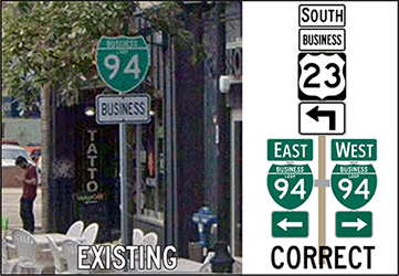 |
||||||||||||||
| History: | c.1960–61 |
||||||||||||||
| 1962 (Nov 2) |
|||||||||||||||
| 1965 (Nov 12) |
|||||||||||||||
| Freeway/Expwy: | Concurrently with US-23 from Exit 37 (Washtenaw Ave interchange) southerly to the route's eastern terminus at I-94 (at US-23 Exit 35 / I-94 Exit 180) | ||||||||||||||
| NHS: | The entirety of BL I-94 (Ann Arbor) is on the National Highway System (NHS). | ||||||||||||||
| Photographs: | |||||||||||||||
| Weblinks: | • BL I-94 (Ann Arbor) @ Michigan Highway Ends – photos of the termini of BL I-94 (Ann Arbor) at Dan Garnell's archived Michigan Highway Ends website. | ||||||||||||||
Port Huron |
Western Terminus: | I-94 at Exit 266 west of Marysville (southwest of Port Huron) | |||||||||||||
| Eastern Terminus: | I-94/I-69 at Exit 275 north of downtown Port Huron (at the foot of the Blue Water Bridge) | ||||||||||||||
| Length: | 9.145 miles | ||||||||||||||
| Map: | Route Map of BL I-94 (Port Huron) | ||||||||||||||
| Notes: | Originally a part of US-25, then redesignated as M-25 after the completion of I-94. | ||||||||||||||
| Signed concurrently with BL I-69 from downtown Port Huron northerly to the northern terminus at the foot of the Blue Water Bridge. | |||||||||||||||
| History: | 1986–87 – All of M-25 in the Port Huron & Marysville area is redesignated as BL I-94, beginning at I-94 at Exit 266 southwest of Marysville and continuing northeasterly via Gratiot Ave through Marysville to Military Ave (nbd) and Electric Ave (sbd) then northerly through downtown port Huron via Huron St and northwesterly via Pine Grove Ave, terminating at I-94/I-69 at the foot of the Blue Water Bridge. At the same time, BS I-69 is redesignated from a spur route into a full loop by extending it concurrently with the new BL I-94 northerly via Huron St and Pine Grove Ave to a shared northern terminus at the foot of the Blue Water Bridge. | ||||||||||||||
| Freeway: | No portion of BL I-94 (Port Huron) is freeway or expressway. | ||||||||||||||
| Expressway: | From Hancock St southerly via the "Connector" to I-94/I-69. | ||||||||||||||
| NHS: | The entirety of BL I-94 (Port Huron) is on the National Highway System (NHS). | ||||||||||||||
| Circle Tour: | |||||||||||||||
| Photographs: | |||||||||||||||
| Weblinks: | • BL I-94 (Port Huron) @ Michigan Highway Ends – photos of the termini of BL I-94 (Port Huron) at Dan Garnell's archived Michigan Highway Ends website. | ||||||||||||||