| Western Terminus: |
Cnr Riverview Dr, Gull Rd & Gull St on the northeast side of Kalamazoo |
| Eastern Terminus1: |
Jct M-89 at cnr E D Ave & N 32nd St in downtown Richland (signed—see note #2 below) |
| Eastern Terminus2: |
Jct M-89 & M-43 at cnr E C Ave & N 32nd St north of Richland (see note #2 below) |
| Length1: |
7.942 miles (signed length—see note #2 below) |
| Length2: |
8.943 miles (see note #2 below) |
| Maps: |
Route Map of M-343 |
| Notes: |
M-343, newly designated in January 2019 and first signed in the field as such in August 2019, is a portion of the former route of M-43 in northern Kalamazoo County orphaned by the massive jurisdictional transfer of state trunkline routes in the City of Kalamazoo. |
| |
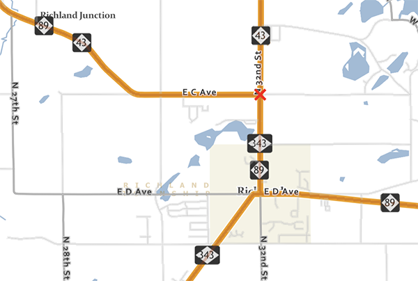
In early 2022 it was discovered via MDOT's own PR-finder/CS Atlas online mapping application that the Department disagrees with itself as to the eastern terminus of M-343. While all M-343 signage in the field has M-343 terminating at M-89 in downtown Richland, the MDOT mapping data clearly shows M-343 continuing northerly for almost exactly one mile to a terminus at Jct M-43 & M-89 at the cnr of E C Ave & N 32nd St, likely to theoretically justify the "343" designation as a "spur" route from M-43, otherwise M-343 would not physically connect with its "parent" route. While it could be postulated the M-343 route markers along M-89/N 32nd Ave are a cartographic error, the official length of M-343 in MDOT's database is given as 8.9428078 miles, or exactly one mile longer than its signed distance, verifying that, at least internally/officially, MDOT believes M-343 to terminate at jct M-43 & M-89 instead of its signed eastern terminus in downtown Richland. (Below is a snippet of the MDOT PR-Finder/CS Atlas online application; the red "X" marks the official eastern terminus of M-343.)
|
| |
In 2019, every through trunkline route in Kalamazoo—BL I-94, BUS US-131 and M-43—as well as the unsigned M-331 were all turned back to local control by MDOT after many, many years of discussion between City and MDOT planners and engineers. City staffers had long sought to eliminate what they termed as "confusing" one-way streets through the heart of downtown Kalamazoo as well as trying to limit or eliminate large trucks from traversing through the city. MDOT, on the other hand, had long stuck to its mandate to provide a smoothly-operating network of arteries, minimizing delays and congestion. The two sides could never come to a satisfactory solution so, in 2018, MDOT staff in Southwest Region finally gave up and acquiesced to the City's demands by agreeing to transfer all downtown trunkline highway routes to local control. As of January 14, 2019, the downtown trunklines became city streets. To retain "route connectivity," MDOT decided to reroute M-43 along US-131 from Kalamazoo to Plainwell, then southeasterly concurrently with M-89 to Richland where it meets back up with the existing route. Unfortunately, this left several "stub routes" terminating at random locations around the city. MDOT employed three different strategies to deal with this:
- Retaining the existing route designation, which is the case for the northern "stub" of BUS US-131 from US-131 Exit 41 to the northern Kalamazoo city limit. It remains BUS US-131, but is a spur route now instead of being a complete loop route through the city.
- Removing any signed designation and maintaining the route as an unsigned state trunkline, as was the case with the former BL I-94/BUS US-131 segment along Stadium Dr from US-131 at Exit 36 to Rambling Rd, and the former M-43 along W Main St from US-131 at Exit 38 easterly to Douglas St.
- Assigning a new route desigation, as was done to the former segment of M-43 along Gull Rd from Richland southwesterly to Riverview Dr northeast of downtown Kalamazoo. This portion of highway was designated M-343 by MDOT Southwest Region staffers in early 2019. Also, the stub of what had been BL I-94 east of the city is redesigated as BS I-94 (Business SPUR I-94).
|
| |
The initially-proposed designation for the portion of former M-43 along Gull Rd between Richland and Kalamazoo was M-242, to recognize its long heritage as having been part of the route of M-43 since 1923. MDOT Central Office staff in Lansing, however, disagreed with local staff's choice of M-242 as Central Office preferred to use even-numbered initial digits for looping routes (or routes that connect with a state trunkline on both ends) and odd-numbered initial digits for spur routes. Therefore, proposed M-242 was then given the desigation of M-343. (M-143 was already taken, assigned to a short segment of E Michigan Ave in East Lansing.) |
| |
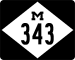
M-343 is the second three-digit state trunkline highway to be signed in the field exclusively with the "wide (stretched) diamond" route marker in its entirety—M-553 in the U.P. was the first. Other three-digit routes may have some "wide diamonds" here or there, but as of its debut in 2019, only M-343 and M-553 are signed exclusively with them. |
| History: |
2000s–2010s – For many years, disagreement about the proper function of the major thoroughfares through downtown Kalamazoo, the most major of which were state trunkline highway routes, existed between City planners and engineers and the planners and engineering staffs at the MDOT regional office. Several attempts were made to find common ground with little to no success. A push in the mid- to late-2010s resulted in City staff members making headway while MDOT staff grew tired of the impass, resulting in the state agreeing to simply turn back all downtown Kalamazoo state highway routes to the City. |
| |
2019 (Jan 7–14) – After the Kalamazoo City Commission agrees to the Memorandum of Understanding from MDOT on the conditions of the trasfer of the affected streets in the city a week earlier on January 7, MDOT approves the changes on January 14, thereby removing them from the state trunkline highway system and transferring them to the city primary street system. For M-43, this affected the entire route from Douglas St west of downtown to the intersection of Riverview Dr & Gull Rd/Gull St northeast of dowtown, including the one-way pair of Michigan Ave (eastbound) and Kalamazoo Ave/Douglas St (westbound) through the heart of the city. |
| |
2019 (June 3–7) – MDOT crews remove the state trunkline route markers from both the transferred roadways in dowtown Kalamazoo as well as along those segments which will remain as unsigned state trunkline routes. Thus, in the field, M-43 becomes a two-segment, disconnected route with route markers trailing off northeast of downtown Kalamazoo and picking back up at the western edge of the city at US-131. The M-43 route markers along the new diversion via Plainwell and the M-343 route markers between Kalamazoo and Richland will be installed at a future date. |
| |
2019 (Aug 19) – MDOT crews begin removing the M-43 route markers from the Richland–Kalamazoo portion of former M-43, replacing them with M-343 markers. M-43 markers are installed along M-89 from Richland northwesterly to US-131 at Plainwell at this time as well. M-343 is now fully signed at this time. |
| Controlled Access: |
No portion of M-343 exists as freeway or expressway. |
| NHS: |
The portion of the former M-43 (now M-343) from M-343's western terminus at Riverview Dr & Gull Rd/Gull St northeasterly to Sprinkle Rd northeast of Kalamazoo is on the National Highway System (NHS). |
| Memorial Highway: |
At present, no portion of M-343 has been designated as part of a Memorial Highway. |
| Photographs: |
|
| Weblinks: |
|