

| Back to Previous Route: M-42 |
 |
On to Next Route: M-44 |
| Western Terminus: | BL I-196/LaGrange St at cnr LaGrange St & Phillips St in South Haven |
| Eastern Terminus: | I-96 Exit 122 at jct I-96 & M-52 near Webberville |
| Length: | 144.230 miles |
| Maps: | Route Map of M-43 |
| Notes: | With the exception of the first, short-lived iteration of M-43, this highway has always taken a rather circuitous path throughout its history as a marked route. Over the past 75-plus years, M-43 has been gradually extended, contracted and realigned so that its 1924 and present-day routings merely touch at one point at Woodbury. Even in modern times, the route of M-43 continues to get even more circuitous—major trunkline changes in Kalamazoo in 2019 resulted in this highway's route undergoing even more change! See the history section below for details on the many changes this highway has undergone. |
| With the completion of I-96 between Brighton and Eagle, bypassing Lansing, in late 1962, US-16 was decommissioned in the state of Michigan. At Lansing, the M-43 designation was extended easterly via then-BUS M-78/Saginaw and Oakland Sts (former US-16), then southeasterly along Grand River Ave (former US-16) through downtown East Lansing and Williamston to end at I-96 near Webberville (running concurrently with then-M-47 for the last two miles). The former route of M-43 along Michigan Ave between downtown Lansing and downtown East Lansing was redesignated as M-143. | |
In 2019, every through trunkline route in Kalamazoo—BL I-94, BUS US-131 and M-43—as well as the unsigned M-331 were all turned back to local control by MDOT after many, many years of discussion between City and MDOT planners and engineers. City staffers had long sought to eliminate what they termed as "confusing" one-way streets through the heart of downtown Kalamazoo as well as trying to limit or eliminate large trucks from traversing through the city. MDOT, on the other hand, had long stuck to its mandate to provide a smoothly-operating network of arteries, minimizing delays and congestion. The two sides could never come to a satisfactory solution so, in 2018, MDOT staff in Southwest Region finally gave up and acquiesced to the City's demands by agreeing to transfer all downtown trunkline highway routes to local control. As of January 14, 2019, the downtown trunklines became city streets. To retain "route connectivity," MDOT decided to reroute M-43 along US-131 from Kalamazoo to Plainwell, then southeasterly concurrently with M-89 to Richland where it meets back up with the existing route. Unfortunately, this left several "stub routes" terminating at random locations around the city. MDOT employed three different strategies to deal with this:
|
|
In "State Trunkline Needs, 1960–1980," a set of maps prepared by the State Highway Dept's Office of Planning, Programming Division in 1960 showing possible additions, upgrades and improvements to the state trunkline system over the ensuing twenty years, MSHD staff recommended many changes to the route of M-43 during that timeframe, including:
|
|
| History: | 1919 (July 1) – As of what can be called the "effective beginning" of the Michigan State Trunkline Highway System in mid-1919, there are not one but two M-43s in the state: one officially designated (but not signed) route and one signed route (that actually has a different underlying official designation!). While the State Highway Dept has earmarked the route between Muskegon and Port Sanilac (with gaps between Casnovia/Kent City and Howard City and from Saginaw to central Tuscola Co) as being M-46, the signed portion of M-46 in 1919 only runs from Howard City easterly to Saginaw. Between M-11 (later US-31 and then BUS US-31) in downtown Muskegon easterly to M-54 (now M-37) near Casnovia, the route is signed as M-43 instead. Interestingly, there is another state trunkline route earmarked as M-43 in mid-1919, beginning at Kalamazoo, proceeding north-northeasterly through Richland and Delton to Hastings, then via Woodland to Woodbury, from there due northerly through Ionia and Sheridan to Stanton where it makes a 90° turn to the east to continue via Ithaca to a terminus at M-47 (present-day M-52) in Saint Charles. None of this route, however, is signed as M-43, though. Additionally, a short connector route between the unsigned M-43 route at Woods Corners north of Ionia and continuing westerly toward Belding to a point near the hamlet of Orleans is earmarked to become M-86, although not yet officially established as a state trunkline highway. M-86, however, is signed along a portion of the route earmarked to become M-66 from M-46 at Six Lakes northerly to M-24 (present-day M-20) at Remus. (This will factor into the history of M-43 in the near future.) |
| 1923 (Early) – By early 1923 (or possibly late 1922), the portion of what is earmarked to become M-66 between Six Lakes and Remus (signed as M-86 since 1919) is part of a northerly signed extension of that route to (at least) Lake City. At this point, the route that is earmarked to become M-86 on official State Highway Dept route maps—specifically Belding Rd from M-44 at the cnr of Belding & Hoyt Rds near Orleans easterly to its planned eastern terminus at State Rd at Woods Corners in Ionia Co—is now actually signed as M-86. In addition—and here is the oddest development!—M-86 is also apparently signed along the route earmarked to become M-43 both northerly from Woods Corners through Sheridan to Stanton and easterly through Ithaca to Saint Charles and southerly from Woods Corners via Ionia, Woodbury, Woodland, Hastings, Delton and Richland to Kalamazoo! This would make M-86 a three-legged route (although not necessarily a complete oddity in the early days of the state highway system) with a northern/eastern terminus (M-47 at Saint Charles), a western terminus (M-44 near Orleans) and a southern/southwestern terminus (M-17 in Kalamazoo.) Confused? You probably should be. | |
1923 (July 5–6) – Of the 6½ counties M-43 is to be officially established in during 1923, the route is officially assumed into the state trunkline system in five of them during these two days. This is is the earliest point when the route, itself newly signed and displayed on road maps throughout as M-86, would likely be re-signed as M-43. The segments established are:
|
|
| 1923 (July 11) – Five days after the lion's share of M-43 is officially established as a state trunkline highway route and transferred to state control, the 1.0 mile segment of the route through the hamlet of Woodbury on the Barry/Eaton Co line between M-39 (present-day M-50) and the Ionia Co line is officially assumed into the system, with half "charged" to Barry Co and half "charged" to Eaton Co. | |
| 1923 (Aug–Sept) – By late summer or fall of 1923, the M-86 markings and route markers which had been recently placed along the established route of M-43 from Kalamazoo to Saint Charles via Hastings, Ionia, Stanton and Ithaca are fully replaced with M-43 signage and markings, leaving M-86 as a short 3.6-mile long connector route between M-44 near Orleans and M-43/State Rd at Woods Corners in northern Ionia Co. Similarly, all M-43 signage along M-46 between Muskegon and Casnovia is removed and replaced with M-46 route markers. | |
| 1925 – By 1925, without an officially established route, the "marked-and-maintained" route of M-43 in Saginaw Co is realigned to continue easterly via Ithaca Rd from the Gratiot Co line to Merrill Rd, then turn northerly via Merrill Rd for 2 miles, easterly for a mile along Grabowski Rd, then southerly for ¾ mile via Chapin Rd, then easterly along Townline Rd to its terminus at M-47 on the north side of Saint Charles. | |
| 1927 (May 18) – Nearly four full years after approximately 90 percent of the route of M-43 is officially assumed into thestate trunkline highway route in 5½ of the 6½ counties it travels through—Saginaw being the one county it was not—the 11.6 miles of M-43 in Saginaw Co is officially established as a state trunkline highway route. It consists of Ithaca Rd from the Gratiot Co line easterly to ½ mile east of Oakley Rd near Saint Charles, then northeasterly via a roadway yet to be constructed to Belle Ave between Coal and Fort Sts, then along Belle Ave northeasterly to a terminus at M-47/Saginaw St in downtown Saint Charles. However, since the officially-established route is not yet fully constructed, the signed (marked-and-maintained) route of M-43 in Saginaw Co remains along the Ithaca–Merrill–Grabowski–Chapin–Townline route it has utilized since at least 1925 (and M-86 used prior to that). | |
| 1927 (May 23), 1928 (Mid) – On, May 23, 1927, a new, gentler sweeping curve for M-43 from the top of the South Ionia hill proceeding down to the river bottom and the Grand River bridge is officially assumed into the state trunkline system at the same time the majority of the former route—today's Belleview Dr—is cancelled as a trunkline and turned back to county control. However, while construction on the new route begins during 1927, the project involves cuts as deep as 25 feet in places and the cut is allowed to "settle over the winter" before the final concrete surface is placed, resulting in the new segment of highway not opening until mid-1928. | |
| 1928 (Mar 12, June 28) – The State Administrative Board approves a new 35-mile long state trunkline route connecting Kalamazoo and South Haven on March 12. Then 3½ months later, on June 28, a long 36.4-mile long state trunkline highway route from the west limits of Kalamazoo westerly into Van Buren Co, through Bangor and then northwesterly to US-31 on the southern edge of South Haven is officially established as a state trunkline route. Initially planned to be a westerly extension of the route of M-96, it is ultimately added to the length of M-43. The new westerly extention to South Haven adds 26% to the length of the route of M-43, although the highway is likely not fully graded and opened to traffic at this point. | |
| 1928 (Apr 30) – A new 1.3-mile long segment of M-43 is officially established as a state trunkline segment just south of Delton in Barry Co near Crooked Lake although work on this portion and the remainder of the segment south to Gull Lake will take until December 1 to complete. The newly-established route eliminates two grade crossings on the Chicago, Kalamazoo & Saginaw Railroad and several sharper turns. The 1.5-mile long former route along present-day Sprague Rd and Floria Rd is cancelled as a state trunkline route and turned back to county control. | |
| 1928 (Aug 8) – The nine blocks (0.5 mile) of the route of M-43 in Hastings from M-37/State St in downtown southerly along S Broadway St then westerly via W Green St to Cass St is officially established as a state trunkline route (instead of being just a "marked-and-maintained" route) and transferred to state control. | |
| 1928 (Aug 8) – A 0.25-mile segment of M-43 running along Alyworth Ave on the southern edge of the City of South Haven in western Van Buren Co is cancelled as a state trunkline highway route. This is actually the westernmost ¼ mile of the route of M-43, having officially terminated at US-31/La Grange Ave at the cnr of Alyworth Ave. M-43 is then redirected to run northerly via a "marked-and-maintained" routing (not officially an established trunkline, but signed as one and maintained by the City) via Bailey Ave from Aylworth Ave to Phillips St, then northwesterly along Phillips St to a new western terminus at US-31/La Grange St. | |
| 1929 (June 12) – Formerly departing downtown Hastings via N Michigan Ave (being under city control and just a "marked-and-maintained" route from downtown northerly to William St) to Woodlawn Ave, then easterly out of the city via Woodlaven Ave, the one block (0.1 mile) of N Michigan Ave that was actually under state jurisdiction between William St and Woodlawn Ave is cancelled as a state trunkline route and turned back to city control, while the 0.7 miles of Woodlawn Ave from N Michigan Ave westerly to N Broadway St and N Broadway St southerly from Woodlawn to M-37 at State Rd is established as a state trunkline route and transferred to state control as a new routing for M-43 in the northern part of Hastings. | |
| 1929 (mid-June) – The route of M-43 in Van Buren Co west of Bangor has been improved while the route to the east is nearing completion, allowing for normal trunkline traffic. | |
| 1930 (Dec 31) – The State Highway Dept works to create a through state trunkline route heading northerly from the Battle Creek area toward the Straits of Mackinac through streamlining several existing disparate state highway routes already existing in that corridor and adding a segment of new trunkline in the middle (roughly along present-day M-66). The new route is given the M-13 route designation, currently in use in Saint Clair Co, but soon to be reassigned as M-136. While the new Battle Creek-to-Edmore trunkline consists of the portion of M-79 from M-78 at Burleigh Corner to Nashville and a new trunkline route from there to jct M-50 & M-43 at Woodbury, the new M-13 will take over the existing route of M-43 from Woodbury northerly through Ionia and Sheridan to M-85 at Stanton, where it replaces the north-south segment of M-85 from Stanton to M-46 west of Edmore. This will result in the truncation of of M-43 at M-50 south of Lake Odessa—its new northern/eastern terminus. The resulting orphaned segment of M-43 from Stanton easterly through Ithaca to Saint Charles is redesignated as M-57 (which is then extended westerly along the east-west segment of M-85 from Stanton westerly to M-66 at Langston, resulting in the retirement of the M-85 designation at this point as well.) Whereas the extension of M-43 from Kalamazoo to South Haven in 1928 extended the length of the route by 26%, this truncation cuts the route almost exactly in half, down to approximately 89 miles. (Oddly, the M-13 designation which replaces M-43 from Woodbury through Ionia to Stanton is redesignated M-14 mere months later due to superstitious issues by motorists and residents!) | |
1931 (May 19) – Act 131 of 1931—the Dykstra Act—is passed allowing the State Highway Dept to take over control of state highways running into and through incorporated cities, thereby officially incorporating them as state trunkline highways. The following segments of formerly city-controlled streets are assumed into the system as part of M-43:
|
|
| 1932 (Oct 29) – A new, 0.9-mile long route for M-43 in eastern Van Buren Co is officially established as a state trunkline route (and likely opened to traffic around this time as well) replacing a 1.3-mile long route beginning approximately ¼ mile west of 29th St and running due easterly along 32nd Ave, then southerly along present-day 29th St and CR-653, then due easterly again along 34th Ave to a point 0.4 mile east of Whiskey Run Rd. The old route is cancelled as a state trunkline route and turned back to local control. | |
| 1937 (Aug 30) – A new, 0.67-mile long route for M-43 in western Kalamazoo Co is officially established as a state trunkline route (and likely opened to traffic around this time as well) replacing a 0.64-mile long route in the Mud Lake Area. The old route, which ran closer to the lake and more closely stuck to the section line with the exception of the western end near the lake, is cancelled as a state trunkline route and turned back to local control. (Much of this roadway is underneath present-day M-43/W Main St between 2nd and 4th Sts.) The newly established segment arcs farther to the north to take the highway farther away from the lake and follows present-day Big Rock Dr. | |
| 1938 (Early) – M-43 is extended easterly from its eastern terminus at Woodbury to replace the M-39 designation through Sunfield, Mulliken, Grand Ledge and Lansing, ending at US-16/Grand River Ave in downtown East Lansing. | |
| 1938 (Dec 6) – To take advantage of the new Michigan Central Railroad underpass on E Michigan Ave east of downtown Kalamazoo and to eliminate the Harrison St grade crossing, the route of M-43 is altered through downtown Kalamazoo. Formerly entering the city from the northeast via Gull St to Harrison St, then southerly to E Michigan Ave, the route will now turn southerly via Riverview Dr to US-12A/E Michigan Ave, then westerly with US-12A/E Michigan Ave to US-12/King Hwy then with US-12/E Michigan Ave back to Harrison St and its former route. The new route is officially assumed into the trunkline system on December 6 at the same time the 0.5-mile long old route is cancelled as a trunkline and turned back to city control. | |
| 1939 (June 10) – A new alignment of M-37 opens between Middleville and Hastings at M-43, creating a four-mile concurrency of M-37 with M-43 at Hastings. | |
| 1939 (July 13) – Several realignments to the route of M-43 from Bangor northwesterly in Van Buren Co remove several sharper and blind turns in the route, two of which result in actual route establishments and cancellations. Starting in Bangor, the portion of the route of M-43 along Lincoln Ave from Monroe St northerly to Black River Rd, then along Black River Rd northwesterly for a total of 0.7 miles is cancelled as a state trunkline route and turned back to local control, replaced by a newly-constructed route just to the south which removes the two sharper turns, also coming in at a total of 0.7 miles. Farther west, a 0.3-mile segment of set of sharp curves where the highway crosses the Merriman Lake Outlet and intersects 63rd St is replaced by a new, 0.3-mile long sweeping curve and the old road is completely obliterated as a public roadway. Farther to the northwest, other windy stretches are also "smoothed out" in an overall effort to improve the safety of the route. | |
| 1939 (Sept 19) – A memorial designation for the portion of M-43 running between Lansing and Grand Ledge is approved by the State Highway Dept in honor of late Governor Frank D. Fitzgerald. As the Frank D. Fitzgerald Memorial Highway, the highway dept anticipates widening the Lansing–Grand Ledge segment to four lanes. In addition to being the 34th (Jan 1, 1935–Jan 1, 1937) and 36th (Jan 1, 1939–Mar 16, 1939) governor of the state of Michigan and the only governor to die while in office, Fitzgerald was also a former business manager for the State Highway Dept. | |
| 1949 (Oct 20) – Whether or not it was to become part of the route of M-43 at that point or not—it is more likely to become part of a realigned US-16 route around downtown East Lansing—the Board of Trustees of the Michigan State College of Agricuture and Applied Science (present-day Michigan State University) votes to grant a right-of-way to the State Highway Dept across its campus adjacent to and immediately north of the Grand Trunk Western Ry as an easterly "Main St Extension" for whenever the department is ready to build such a highway. | |
| 1950 (Nov 3) – Two realignments to the route of M-43 at Bangor in Van Buren Co are officially assumed into the state trunkline system and likely open to traffic around this time as well. In Bangor, M-43 now continues southeasterly 0.8 mile from Center St via E Monroe St to Randolph St, which is transferred to state control, then via a newly-constructed alignment merging back into its previous alignment at E Arlington St approximately 0.2 mile east of the Bangor city limit. The former 1.0-mile long route along Center St and Arlington St is turned back to local control. A little farther east, another newly-constructed alignment removes two 90° turns from the route of M-43. Beginning approximately ¼ mile east of 54th St, the new alignment sweeps southeasterly, then curves back to the east to merge back into existing M-43 at the cnr of 52nd St & 32nd Ave, for a total of 1.0 mile of newly established state trunkline mileage. The former route—0.8 mile of 30th Ave from the new highway easterly to 52nd St and 0.5 mile of 52nd St from 30th Ave southerly to 32nd Ave—is cancelled as a state trunkline highway and turned back to county control. Interestingly, the State Highway Dept had purchased rights-of-way for both of these realignments in 1933–34, but did not built the new highway segments at that time! For the realignment in Bangor, the MSHD abandoned the originally-purchased right-of-way and instead purchased new ROW running on the same alignment as existing Monroe St. For the sweeping curves between 54th St and 52nd St, the MSHD had purchased a 100 ft ROW in 1933–34, but then bought an additional 10 feet in 1949 to make it a full 120-foot right-of-way in which to build the new highway in 1950. |
|
| 1950 (Nov 30) – The 1.1 miles of Capitol Ave in downtown Lansing from M-43/Saginaw St southerly to US-27/M-78/Main St (present-day Malcolm X St), which has been signed as PASSENGER CAR ROUTE US-27 & M-78" is cancelled as a state trunkline route and turned back to city control with the formerly-designated TRUCK US-27/TRUCK M-78 along Larch St becoming just US-27/M-78. Thus, the segment of Saginaw St from Capitol Ave to Larch St is now just M-43 while Larch St becomes just US-27/M-78/M-43. | |
| 1954 (Jan) |
|
| 1955 (Aug 3) – The route of M-43 is realigned in northeastern-most Barry Co. From Woodland, the 2.0 miles of E Broadway St (in the village of Woodland) and Carleton Center Rd easterly to M-66/Clark Rd is established as a stste trunkline route and transferred to state control. At the same time, a new, gradually-sweeing curve for M-66 beginning at Carleton Center Rd and continuing northeasterly to the Barry/Eaton Co line at Jordan Rd–Saginaw Hwy, is similarly established as a trunkline with the route continuing northerly along the county line to the jct of M-43, M-50 & M-66 just south of Woodbury. M-43 now also runs concurrently with M-66 along this new alignment between Carleton Center Rd and M-50 as well. The former route of M-43 from Woodland northerly via Main St–Woodland Rd, then easterly along Brown Rd to M-50 southeast of Lake Odessa is cancelled at this point as well and turned back to local control. | |
| 1956 (Nov 21) – A further 12.5-mile long rerouting/realignment for M-43 in northeastern Barry Co officially opens to traffic as highway crews finish erecting M-43 route markers along the new route signalling the completion of the $810,000 project that moves the route onto N Broadway St heading northerly out of Hastings to a new sweeping curve that now takes M-43 easterly onto Carlton Center Rd and easterly into the village of Woodland. (Ironically, the Barber Rd-to-Woodland portion of Carleton Center Rd had been part of M-43 from 1923 to 1928!) The new route is currently a "marked-and-mainted" route for the time being and the former route along Woodlawn Ave, Barber Rd, Coats Grove Rd, and Woodland Rd (S Main St in Woodland) is retained, temporarily, as an unsigned state trunkline highway. | |
| 1957 (June 17) – The 12.5 miles of realigned M-43 officially opened to traffic in November 1958 between Hastings and Woodland in northeastern Barry Co is officially established as a state trunkine highway route and transferred to state control, while the 12.3 miles of former M-43 route along Woodlawn Ave, Barber Rd, Coats Grove Rd, Woodland Rd and S Main St is officially cancelled as a state trunkline highway route and turned back to local control. | |
| 1959 (Nov 13–16) – A 2.3-mile long southwesterly M-43 bypass of the City of Grand Ledge is completed and opened to traffic on Friday, November 13 while it is officially established as a state trunkline route the following Monday, November 16. The two-lane bypass, which cost $350,000 to build, is constructed in the northern half of a four-lane right-of-way with room for an additional, separate two-lane roadway to the south in the future if traffic volumes warrant an expansion. The former route of M-43 through downtown Grand Ledge is retained as a staste highway and redesignated as BUS M-43. | |
| 1962 (Nov 2) – An 11-mile segment of the US-131 freeway is completed and opened to traffic from M-89 west of Plainwell southerly to M-43/W Main St on the west side of Kalamazoo. From the southern end of the new freeway segment, US-131 is temporarily designated along M-43/W Main St easterly into downtown Kalamazoo back to its former route at Westnedge Ave. | |
| 1962 (Dec 12) – With the completion of I-96 between Brighton and Eagle, bypassing Lansing, US-16 is decommissioned in Michigan. In Lansing (from the jct of US-27/M-78/BL I-96), the M-43 designation in Lansing now continues easterly from US-27/BL I-96/Cedar-Larch Sts concurrently with M-78/Saginaw-Oakland Sts (former US-16—ebd M-43 along Saginaw St with M-78 ebd and BL I-96 ebd, wbd M-43 along Grand River Ave & Sheridan St with M-78 wbd and BL I-96 wbd), then southeasterly via Grand River Ave (former US-16) through downtown East Lansing and Williamston to end at I-96 near Webberville, running concurrently with M-47 for the last two miles. The former route of M-43 via Michigan Ave between downtown Lansing and downtown East Lansing is redesignated as M-143. (The 0.752-mile long segment of Stockbridge Rd from Grand River Ave west of Webberville southerly to the new I-96 interchange is actually officially established as a state trunkline route seven months earlier on May 15.) | |
| 1963 (Sept 30) – The 10½-mile long segment of the US-131 freeway from M-43/W Main St at Kalamazoo southerly to the Shaver Rd & Westnedge Ave intersection north of Schoolcraft is completed and opened to traffic, resulting in the removal of the US-131 from the segment of M-43 between the US-131 freeway and downtown Kalamazoo from the previous November. | |
| 1963 (Dec 16) |
|
| 1963 (Dec 20) – With the completion of the first segment of the I-496 "Pine Tree Connector" southeast of Lansing, M-78 is rerouted to bypass the City of Lansing to the south and east via I-96 and I-496 witjh the concurrent portion of M-43/M-78 along the Saginaw-Oakland Sts one-way pair and Grand River Ave on the east side of the city becoming BL I-96/M-43/BUS M-78. | |
| 1964 (Nov 20) – In the City of Lansing, a new 0.983-mile route consisting of Elliot St from Center St from the west end of the newly extended Sheridan St (present-day Oakland Ave) to the Grand River, the under construction Grand River bridge, the six blocks of Jefferson St from Grand Ave to Pine St, a new connection between Pine St and Wisconsin Ave, and Oakland Ave from Wisconsin to Logan St (present-day Martin Luther King Jr Blvd) is officially established as a state trunkline route and transferred to state control. This new route will become the second phase of the westbound side of the M-43 Lansing crosstown route when it is completed and opened to traffic in two months time. | |
| 1965 (Jan 31) – The second phase in splitting east-west Lansing crosstown traffic onto a pair of one-way streets is completed when the connection between Sheridan St at Center St and Jefferson St at Washington Ave via a new bridge spanning the Grand River is completed and opened to traffic. Wbd M-43 traffic is now routed westerly over the new span, then along what had been known as Jefferson St to Pine St, then over a newly-built connector that curves slightly southwesterly to the eastern end of Oakland Ave, then westerly along Oakland Ave to Logan St (present day Martin Luther King Jr Blvd), then southerly along Logan back to Saginaw St. The Lansing City Council also passes an ordinance renaming all of Jefferson St, the short Elliot St and most of Sheridan St as an easterly extension of Oakland Ave so that the new westbound side of M-43 (west of the Grand River Ave turn-off) has one consistent street name. Saginaw St between Logan and Center St is now eastbound M-43 only. | |
| 1965 (Oct 4–10) – To facilitate increased traffic and to combat increasted congestion within downtown Kalamazoo, the east-west state trunkline routes through the center of the city are split into a one-way pair, with traffic changes taking affect on 1:00 pm October 10. Main St from Douglas St easterly to Michigan Ave and Michigan Ave easterly to Kalamazoo Ave becomes eastbound only M-43, while Kalamazoo Ave from Michigan Ave to Douglas St and Douglas from Kalamazoo southerly one block back to W Main St is now signed as westbound M-43. Ebd M-43 along the Michigan Ave segment is co-signed with ebd BL I-94, while Kalamazoo Ave from Michigan Ave westerly to Westnedge Ave at the newly-constructed "Michikal St" connector is now co-signed with wbd BL I-94. The portion of Michigan Ave from W Main St easterly to N Park St is also part of the route of nbd BUS US-131 as well. Kalamazoo Ave from Michigan Ave westerly to N Park St and the one block of Douglas Ave between Kalamazoo Ave and W Main St had been officially assumed into the state trunkline system the previous Monday on October 4. (The eight blocks of W Kalamazoo Ave from N Park St westerly to Douglas Ave had previously been assumed into the trunkline system in 1931 as part of the route of US-131, which was transferred to its new freeway bypass alignment west of the city in September 1963.) | |
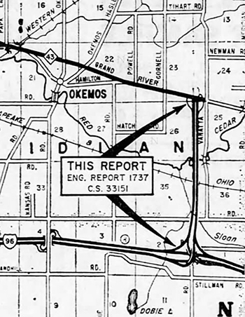 1966 (Mar 9, July 14) – The Dept of State Highways approves the engineering report on March 9 for the "Van Atta Connector," a proposed four-lane freeway beginning at I-96 approximately 2½ miles east of Okemos Rd and proceeding northerly along the section line just west of Van Atta Rd (hence the name) to a diamond interchange at M-43/Grand River Ave, where it would temporarily terminate. At this point, the M-43 designation would be applied to the Van Atta Connector between Grand River Ave and I-96 and Grand RIver Ave from this point easterly through Williamston to M-47 (present-day M-52) would be turned back to local control. A public hearing is held on July 14. A future extension of the Van Atta Connector would take the freeway from M-43/Grand River Ave northerly past Lake Lansing to an interchange with the proposed I-69 freeway northeast of Haslett. 1966 (Mar 9, July 14) – The Dept of State Highways approves the engineering report on March 9 for the "Van Atta Connector," a proposed four-lane freeway beginning at I-96 approximately 2½ miles east of Okemos Rd and proceeding northerly along the section line just west of Van Atta Rd (hence the name) to a diamond interchange at M-43/Grand River Ave, where it would temporarily terminate. At this point, the M-43 designation would be applied to the Van Atta Connector between Grand River Ave and I-96 and Grand RIver Ave from this point easterly through Williamston to M-47 (present-day M-52) would be turned back to local control. A public hearing is held on July 14. A future extension of the Van Atta Connector would take the freeway from M-43/Grand River Ave northerly past Lake Lansing to an interchange with the proposed I-69 freeway northeast of Haslett. |
|
| 1966 (Oct 14) – With the completion of the US-127 freeway from Mason to I-96 southeast of Lansing, the BL I-96/M-43/BUS M-78 designation along Saginaw St, Oakland St and Grand River Ave in Lansing becomes US-127/M-43/BUS M-78. | |
| 1967 (Sept 29) – The 1.561 miles of W Jefferson St in Grand Ledge from M-100/Bridge St westerly to M-43 is cancelled as a state trunkline highway route and transferred to local control, thus bringing an end to the route of BUS M-43 at Grand Ledge. The concurrent M-100/BUS M-43 along E Jefferson St from Bridge St to Willow Hwy and along S Clinton St from Willow Hwy to M-43/Saginaw Hwy retains the M-100 designation. | |
| 1968 (Aug 30) |
|
| 1968 (Oct 2–7) – The third and final phase of the east-west Lansing crosstown project for M-43 is finished on October 7 when westbound M-43 traffic is moved onto Oakland Ave from Logan St (present-day Martin Luther King Jr Blvd) westerly to the Beltline Railroad at the west Lansing city limit, while existing M-43 along Saginaw St between those points is converted to eastbound only traffic. The segment of Logan St between Saginaw St and Oakland Ave which had been temporarily "marked-and-maintained" as part of westbound M-43 since early 1965 is turned back to city maintenance, while the Beltline Railroad underpass for M-43 at the point where the new Oakland Ave connection back into Saginaw St at the west city limit is not yet complete and a temporary connection west of Stanley St brings wbd M-43 traffic back to Saginaw St on its existing alignment. The 0.737 miles of Oakland Ave—both the existing segment of street from Logan St westerly to Cawood St as well as the newly constructed connector back to Saginaw St from Cawood St southwesterly Stanley St—is officially established as a state trunkline highway route five days prior to the street opening on October 2 and the Logan–Cawood segment is transferred to state control. The 0.469-mile segment of realigned M-43 via the Beltline Railroad underpass immediately south of existing M-43/Saginaw St from Stanley St westerly to Rosemary Ave is also officially established as a state trunkline route on October 2 as well. | |
| 1968 (Nov 19, Dec 16) – The eastbound M-43/Saginaw St lanes of the new Beltline Railroad underpass at the Lansing west city limit are opened to traffic on November 19. Westbound traffic continues to use the temporary at-grade crossing to the north while the westbound lanes leading from the newly-completed Oakland Ave connector are completed, which occurs on December 16 and the former route of Saginaw St is largely obliterated. | |
| 1969 (Feb 20) – The 0.404 miles of the former route of M-43/W Saginaw St through the Beltline Railroad crossing at the Lansing west city limit replaced by the underpass completed and opened to traffic in two phases during November and December of 1968 is officially cancelled as a state trunkline route. It has been largely obliterated, athough a segment of the old highway to the west of the railroad survives as part of the access roadway serving the Oldsmobile Differential Plant and Foundry (later the Lansing Craft Center). | |
| 1969 (Sept 19) – The Michigan State University Board of Trustees unanimously approves construction of an M-43 expressway from I-496/US-127 at Trowbridge Rd (present-day Exit 7) easterly through the Michigan State University campus immediately north of the Grand Trunk Western Ry connecting with existing M-43/Grand River Ave west of Okemos. The new highway will be six lanes divided from I-496/US-127 easterly across campus to Hagadorn Rd and four lanes divided from there to where it merges back into Grand River Ave. While the new route will intersect Harrison and Hagadorn Rds at grade, it will pass under Farm Ln and pass over Bogue St on its way through campus. An additional $1.7 million worth of ramps and bridges were originally buiilt to connect Trowbridge Rd into the I-496 & US-127 interchange to accommodate the planned M-43 cross-campus expressway route. This action essentially reaffirms the actions of the MSC board twenty years prior when the right-of-way was initially reserved for the proposed highway. | |
| 1969 (Nov 7) – With the completion and opening of the 10-mile reconstruction of Stockbridge Rd in eastern Ingham Co from one mile south of Millville (White Oak) at the former northern terminus of M-52 at M-36 northerly to the I-96 interchange with M-43 (today's Exit 122), the M-52 designation is extended northerly over Stockbridge Rd to I-96, then concurrently with M-43 (replacing the concurrent M-47 designation) for 2.0 miles along Stockbridge Rd northerly to Grand River Ave and along Grand River Ave to Perry Rd. There, M-52 takes over the route of M-47 northerly through Perry, Owosso, Oakley and Saint Charles to M-46 west of Saginaw. | |
| 1970 (Apr 24) – The State Highway Dept announces the start of surveying for the construction of the M-43 expressway in East Lansing across the Michigan State University campus from Harrison Rd easterly to M-43/Grand River Ave west of Okemos. The MSHD plans to have this segment of highway out for bids in November 1973 and completed and opened to traffic in December 1975. | |
| 1971 (June 18, Oct 14, Nov 19) – The Michigan State University Board of Trustees votes in a closed June 18 meeting to reject the cross-campus M-43 expressway the State Highway Dept has long planned to build from the eastern end of Trowbridge Rd at Harrison Rd easterly adjacent to the Grand Trunk Ry to Hagadorn Rd where it would have continued on back to existing M-43/Grand River Ave west of Okemos. An October 14 public hearing finds considerable opposition to the route, largely based on the assumed increase in polution the new highway would bring to the campus, leading the University's board to, again, reject the highway propsal at its meeting on November 19. The City of East Lansing Council similarly withdrew its support for the highway by a narrow 3–2 vote earlier in the week, although on that same evening the City of Lansing Council had reaffirmed its support after noting it had helped fund the route of I-496 through Lansing in good faith that the M-43 expressway across the MSU campus would eventually be constructed. | |
| 1971 (Dec 4) |
|
| 1972 (Dec 29) – Possibly in preparation for the proposed M-37 Hastings-Battle Creek Expressway, the route of M-37/M-43 from downtown Hastings westerly to the western jct of M-37 & M-43 is moved to its present-day alignment. The former route of M-37/M-43 via Green St will be turned back to local control the next year. | |
| 1973 (Mar 30, Jun 27) – The former route of M-37/M-43 from downtown Hastings westerly superseded by the present-day alignment (see above) is turned back to local control. Green St from downtown Hastings (at Broadway St) westerly to the west city limit is turned back to city control on March 30, while the portion in Rutland Twp from the west limit of Hastings westerly to the new alignment is turned back to the county on June 27. | |
1973 (Nov 19)
|
|
| c.1981 – The proposed M-43/Van Atta Connector (or Van Atta Freeway) which had been proposed to begin at M-43/Grand River Ave just west of Van Atta Rd in Ingham Co's Meridian Twp and running due southerly for approximately 2½ miles to a directional interchange at I-96 in Alaiedon Twp is officially cancelled by MDOT and dropped from all future transportation plans. | |
| 1987 (Nov 23) |
|
| 1991 (Apr 29) |
|
| 2004 (Nov 2) – The 1.470-mile route of OLD M-43 in eastern Van Buren Co's Alamena Twp, from M-43 west of 29th St to M-43 west of CR-653, is turned back to county control in its entirety. This segment of highway had been bypassed by the present-day route of M-43 three decades prior in 1973 and the old, unsigned trunkline route is finally cancelled as a trunkline route and transferred to county control. | |
| 2000s–2010s – For many years, disagreement about the proper function of the major thoroughfares through downtown Kalamazoo, the most major of which were state trunkline highway routes, existed between City planners and engineers and the planners and engineering staffs at the MDOT regional office. Several attempts were made to find common ground with little to no success. A push in the mid- to late-2010s resulted in City staff members making headway while MDOT staff grew tired of the impass, resulting in the state agreeing to simply turn back all downtown Kalamazoo state highway routes to the City. | |
| 2019 (Jan 7–14) – After the Kalamazoo City Commission agrees to the Memorandum of Understanding from MDOT on the conditions of the trasfer of the affected streets in the city a week earlier on January 7, MDOT approves the changes on January 14, thereby removing them from the state trunkline highway system and transferring them to the city primary street system. For M-43, this affected the entire route from Douglas St west of downtown to the intersection of Riverview Dr & Gull Rd/Gull St northeast of downtown, including the one-way pair of Michigan Ave (eastbound) and Kalamazoo Ave/Douglas St (westbound) through the heart of the city. | |
| 2019 (June 3–7) – MDOT crews remove the state trunkline route markers from both the transferred roadways in dowtown Kalamazoo as well as along those segments which will remain as unsigned state trunkline routes. Thus, in the field, M-43 becomes a two-segment, disconnected route with route markers trailing off northeast of downtown Kalamazoo and picking back up at the western edge of the city at US-131. The M-43 route markers along the new diversion via Plainwell and the M-343 route markers between Kalamazoo and Richland will be installed at a future date. | |
| 2019 (Aug 19, Late Oct) – MDOT crews begin removing the M-43 route markers from the Richland–Kalamazoo portion of former M-43, replacing them with M-343 markers in mid-August. M-43 markers are also installed along M-89 from Richland northwesterly to US-131 at Plainwell in mid-August as well. M-43 is still a two-segment disconnected route—as far as the signed route is concerned in the field—as M-43 is not indicated as following US-131 in any way until M-43 reassurance markers are posted along that route in late October. Exit signage at the M-43/W Main St interchange on US-131 is also modified, however the modifications are done incorrectly and all M-43 route markers are removed from the advance exit signage, when the proper modification would have been to add the "WEST" legend to the signs to indicate that M-43 only goes west from the freeway now instead of both directions. | |
| Controlled Access: | M-43 is a controlled-access freeway concurrently with US-131 from Exit 38 west of Kalamazoo northerly to M-89 at Exit 49 at Plainwell. (10.7 miles) |
| The new-construction (1959) portion of the M-43 "Grand Ledge bypass" is a two-lane, limited-access expressway on a four-lane right-of-way from the cnr of Grand Ledge Hwy & Jefferson St west of the city southeasterly to Saginaw Hwy. (1.4 miles) | |
| NHS: | Two segments of M-43 are on the National Highway System (NHS):
|
| Memorial Highway: | The following Memorial Highway designation has been officially assigned to a part of M-43 by the Michigan Legislature:
|
| Photographs: | |
| Weblinks: |
|
| Back to M-42 | Route Listings Home | On to M-44 |