| Western Terminus: |
US-31 in Norton Shores just southeast of Muskegon |
| Eastern Terminus: |
I-75/Fisher Frwy at Exit 48 in downtown Detroit |
| Length: |
192.014 miles |
| Maps: |
Route Map of I-96 |
| Notes: |
I-96 is Michigan's only two-digit intrastate Interstate highway, existing only within the state. |
| |
I-96 replaced the route and designation of US-16 in Michigan in 1963. (See the Historic US-16 pages for more information.) As with most of Michigan's other Interstates, the "freeway-ization" of the I-96 corridor was well underway even before the signing of the Interstate Highway Act into law in 1956. It is interesting, though, to note the highway was not fully complete in the Detroit area until 1977. |
| |
The I-96 originally proposed in the late 1950s and the I-96 of today run along very different routes west of Grand Rapids. I-96 was originally proposed to run westerly from Detroit through Lansing to Grand Rapids. There, a spur route designated I-196 was proposed to continue along the US-16 corridor to Muskegon, while I-96 was to head southwesterly to Holland and from there southerly along with US-31 to I-94 northeast of Benton Harbor. The first segments of present-day I-196 in Berrien and Van Buren Cos were opened as I-96 and all of present-day I-96 from Muskegon to Grand Rapids was opened as I-196 and for a few years the freeway "inexplicably" changed numbers at today's Mile 37 on the east side of Grand Rapids. Also, some commercial road maps of the day marked the segment of I-94 from Benton Harbor southwesterly into Indiana concurrently as "I-94/I-96." Whether any I-96 route markers were ever erected along I-94 in this area is highly doubtful, though. The American Association of State Highway Officials (AASHO) approved a swap of the two route designations in October 1963 and the change was implemented during the second week of January 1964. At this moment, what had been planned as BL I-96 at South Haven becomes BL I-196, while Muskegon's BS I-196 is redesignated as BS I-96. |
| |
In Detroit, I-96 was originally proposed to follow a different routing than was eventually taken. The Jeffries Frwy was originally proposed to run parallel to Grand River Ave (then US-16) from downtown Detroit all the way to Farmington, where the Brighton-Farmington Expwy was constructed (and still in use today as M-5 and I-96). One portion of today's I-96/Jeffries Frwy that actually follows this early proposed route runs from West Grand Blvd to West Chicago. Over time, the western alignment along Schoolcraft Rd through Redford Twp and Livonia became the preferred routing of the freeway. Originally through Livonia, the State Highway Dept wanted to build the freeway as a "normal" suburban freeway at ground level with larger interchanges. After haggling and discussion by local government and state legislators, the department gave in and constructed the Jeffries as the urban "depressed" freeway you see today. From the western side of Livonia, I-96 was then to be routed north concurrnetly with I-275 back to its former alignment—which is does today. |
| |
Also in Detroit, that funky "dog-leg" in the Jeffries, where it passes under Grand River Ave twice (in the Wyoming and Davison Ave area), was constructed as a full freeway-to-freeway interchange to accommodate a future connection with the Davison Frwy (now M-8). However, the City of Detroit in the 1970s refused to allow any additional freeways to be built. Although this connection may never be fully utilized, the portion of Davison Ave from I-96/Jeffries Frwy easterly to the beginning of the M-8/Davison Frwy was transferred from the City of Detroit to MDOT in 2001 and is now part of M-8. For now, it can be safely assumed MDOT has no greater plans for the Davison and this interchange. |
| |
An interesting connection exists between I-96 and the only known route designated as "M-2" in the history of the Michigan highway system. In preparation for the construction of the Jeffries Frwy in the western portion of the City of Detroit and across Redford Twp and the City of Livonia in the early- and mid-1970s, Schoolcraft Ave was transferred to state control and given the internal/secret M-2 route designation. The I-96/Jeffries Frwy was constructed along and in the median of Schoolcraft Ave from west of Evergreen Rd in Detroit to west of Newburgh Rd in Livonia and the State constructed the new version of Schoolcraft Ave to act as the Jeffries Frwy service drives (frontage roads). While a similar set-up existing along the route of I-696 in Macomb Co resulted in 11 Mile Rd being temporarily designated "M-6" in the 1970s as well, it seems 11 Mile Rd was actually signed as M-6 for a time, while no evidence of Schoolcraft Ave being signed as M-2 has surfaced. Site contributors Dyche Anderson, Dave Outen and Jim Lindsay were all kind enough to corroborate the Schoolcraft Ave-as-M-2 theory and one AAA Michigan-produced roadmap from that timeframe also labeled the route as M-2 as well. However, to date, M-2 in the Jeffries Frwy corridor has never shown up on any official Michigan highway map or other MDOT publication. —Many, many thanks to Dyche, Dave and Jim! |
| |
Allan M. Williams (1892–1979), Ionia County Highway Engineer, had a major impact on several areas of Michigan's highway system, well beyond his day-to-day job helping to design and maintain the roads in Ionia County. In 1929, he introduced the first publicly accessible roadside picnic table on state government right-of-way and a historical marker along Grand River Ave south of Saranac denotes this site to this day. Because of this, MDOT installed many hundreds more of these tables in Roadside Parks and Rest Areas across the state and continues maintaining many of these areas today. Williams also helped draft Michigan's first official road map, collaborated in developing the diamond-shaped route marker that bears the designations of state trunkline routes, and pioneered the use of the angled, concave, straight-blade, front-mounted snowplow. But, most notably for I-96, according to MDOT notes that "in 1926, Williams cut the opening ribbon for the last paved stretch of improved US-16. In 1977, he was asked to perform the same task for the final section of the successor parallel road, I-96." |
| |
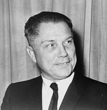  I-96 is actually involved in one of the innumerable theories over the final resting place of James R. Hoffa, the labor union leader who served as the president of the International Brotherhood of Teamsters from 1957 until 1971. Hoffa disappeared from the Machus Red Fox restaurant in Bloomfield Hills and his body was never found. Countless theories have been advanced as to Hoffa's final resting place in the decades since, ranging from the theoretically plausible to the downright absurd. One (unproven) transportation-related theory is he is interred in the concrete dividing barrier which was currently under construction along the I-96/Jeffries Frwy in northwest Detroit. This segment between Grand River/Schaefer and the M-39/Southfield Frwy had been under construction for a few years at that point, so while there is absolutely no tangible evidence of Hoffa's remains being incorporated into the concrete being poured, the timeline, at least, does match up. I-96 is actually involved in one of the innumerable theories over the final resting place of James R. Hoffa, the labor union leader who served as the president of the International Brotherhood of Teamsters from 1957 until 1971. Hoffa disappeared from the Machus Red Fox restaurant in Bloomfield Hills and his body was never found. Countless theories have been advanced as to Hoffa's final resting place in the decades since, ranging from the theoretically plausible to the downright absurd. One (unproven) transportation-related theory is he is interred in the concrete dividing barrier which was currently under construction along the I-96/Jeffries Frwy in northwest Detroit. This segment between Grand River/Schaefer and the M-39/Southfield Frwy had been under construction for a few years at that point, so while there is absolutely no tangible evidence of Hoffa's remains being incorporated into the concrete being poured, the timeline, at least, does match up. |
| |
"State Trunkline Needs, 1960–1980," a set of maps prepared by the State Highway Dept's Office of Planning, Programming Division in 1960 showing possible additions, upgrades and improvements to the state trunkline system over the ensuing twenty years. However, as segments of I-96 had been recently constructed, were currently being constructed, or already in the design process at that time, the maps show the entire I-96 corridor almost exactly as it was eventually configured. The primary difference between the maps and what was eventually constructed deal mainly with a few interchanges (either ones which were never built or additional ones which were constructed) and concurrent route designations, such as US-16 remaining co-signed with I-96 between Muskegon and Detroit. |
| History: |
   NOTE: This history section for I-96 includes the history of any earlier route segments which were eventually incorporated into the route of I-96, which largely consists of portions of US-16 and the original I-196. Look for the route marker symbols denoting the original designation being referred to at the beginning of each history entry. To skip the "Pre I-96" history of this route, you may also choose to jump to the techincal beginning of the history of I-96 in 1959. NOTE: This history section for I-96 includes the history of any earlier route segments which were eventually incorporated into the route of I-96, which largely consists of portions of US-16 and the original I-196. Look for the route marker symbols denoting the original designation being referred to at the beginning of each history entry. To skip the "Pre I-96" history of this route, you may also choose to jump to the techincal beginning of the history of I-96 in 1959. |
| |
1957 (Aug 15) – The first four miles of the 22-mile, $19 million "Brighton–Farmington Expressway" are completed from US-23 east of Brighton to the Livington/Oakland Co line and opens to traffic. The remainder of the freeway extending into Oakland Co and merging back into existing US-16/Grand River Ave just east of Farmington, remain under construction. The new freeway consists of 18 miles of brand-new route on new alignment from Brighton to west of Farmington (cnr Grand River Ave & Halsted Rd), while the remainder bypassing Farmington to the south is being constructed immediately adjacent to the existing US-16 bypass of that city (present-day Freedom Rd). The former route of US-16 along Grand River Ave from US-23 at Brighton easterly to the Livingston/Oakland Co line is retained as an unsigned trunkline route for the time being. (Grand River Ave is now discontinuous at the Livingston/Oakland Co line as the new freeway uses the existing US-16 bridge over the Huron River at Kent Lake.) |
| |
1957 (Aug 20) – The eastbound lanes of the US-16 "Farmington Bypass" are completed and opened to traffic from Grand River Ave west of Farmington back to Grand River Ave southeast of the city. These first two lanes of the eventual four-lane freeway effectively replace the eastbound-only US-16 "Farmington Cut-off" constructed in the early 1930s. (Westbound US-16 traffic has been forced to travel through downtown Farmington for more than two decades.) The westbound lanes of the "Farmington Bypass" on the US-16 Brighton–Farmington Expwy are still under construction, however. |
| |
1957 (Dec 13) – The remainder of the 22-mile long US-16/Brighton-Farmington Expwy is completed and opened to traffic with ribbon-cutting ceremonies at Brighton, Wixom, Novi and Farmington. The segment from US-23 east of Brighton to the Livingston/Oakland Co line and the "Farmington Bypass" portion had opened to traffic earlier in the year. Steel shortages due to the 1956 steelworkers strike held up completion of over- and underpasses at Wixom Rd and the C&O Railway overpass at Novi. While the new freeway is signed as part of US-16, the former route along Grand River Ave from Brighton to Farmington (with a physical gap at the Huron River at Kent Lake) is retained as an unsigned state trunkline highway route for the time being. |
| |
1957 (Dec 24–30) – Approximately 8½ miles of US-16 freeway are completed and opened to traffic on December 24 from the west side of Coopersville (present-day Exit 16) to just east of Marne (present-day Exit 24) in Ottawa Co, bypassing Coopersville to the south and Marne to the north. From the west end of the new freeway segment west of Coopersville to 40th Ave just east of Coopersville, the former route along Randall St and Ironwood Dr is turned back to local control six days later on December 30, as is the former route bypassing Marne to the south via Berlin Fair Dr and Hayes St. (From 40th Ave east of Coopersville to just west of Marne, the new freeway consumes the original route of US-16.) |
| |
1958 (Jan 20) – An 8½-mile stretch of US-16 freeway is completed and opened to traffic between existing US-16/Grand River Ave southeast of downtown Portland (at present-day Exit 77) , continuing southeasterly and east-southeasterly to the north of the former route past Eagle to M-100 north of Grand Ledge (present-day Exit 86), where the new freeway merges back into exisiting US-16 via a temporary connector roadway. No ribbon-cutting ceremonies are held to mark the opening of the $3.88-million highway, which is opened to traffic six months early. |
| |
1958 (Jan 24) – The 5.85-mile segment of the US-16 freeway in southwestern Clinton Co from existing US-16/Grand River Ave just east of M-100 north of Grand Ledge, northwesterly through Eagle to the Ionia Co line is officially established as a state trunkline highway route, four days after opening to traffic. At the same time, the former route of US-16 along Grand River Ave from just east of M-100 to the Clinton/Ionia Co line is turned back to county control. |
| |
1958 (Sept 16) – The 17.59 miles of the US-16 Brighton–Farmington Expwy in Oakland Co from the beginning of the "Farmington Cut-Off" southeast of Farmington westerly to the Livingston Co line is officially established as a state trunkline highway route. Simultaneously, the 17.1 miles of former US-16 along that same stretch is turned back to local control, specifically the 4.3 miles of the original "Farmington Cut-Off" (Freedom Rd) around the south side of Farmington and the portion of Grand River Ave from Halsted Rd westerly through Novi and New Hudson to the Kent Lake Rd interchange at Kensington Metropolitan Park. |
| |
1958 (Dec 18, 11:00 am) – An additional 20-mile segment of the US-16 freeway across much of Ionia Co is completed and opened to traffic (more then eight months ahead of schedule) from a temporary ramp constructed at Hastings Rd northwest of Clarksville to Portland Rd (present-day Exit 73) west of Portland. A four-mile gap in the freeway between Kent St and Grand River Ave remains, however, on the south side of Portland. Through US-16 traffic is routed from Portland Rd easterly via Grand River Ave (the former route of US-16) back to the freeway southeast of town. The former route of US-16 along Grand River Ave from Hastings Rd to downtown Portland remains an unsigned state trunkline route for the time being. |
| |
1959 (June) – The four-mile gap in the US-16 freeway around the south side of Portland is completed and opened to traffic from Portland Rd west of the city (present-day Exit 73) to Grand River Ave southeast of town (present-day Exit 77). The former route of US-16 along Grand River Ave through downtown Portland remains an unsigned state trunkline route for the time being. |
| |
1959 (Nov 4) – After being severed by the Brighton–Farmington Expwy two years earlier, a new Grand River Ave bridge spanning the Huron River at the outlet of Kent Lake in western Oakland Co is completed and opened to traffic. The original alignment of Grand River Ave at the Huron River was subsumed into the alignment of the new freeway in 1957, thereby causing Grand River Ave to be discontinuous between Livington and Oakland Cos. After complaints from both local residents and business owners, a new alignment for Grand River is constructed immediately to the south of the freeway alignment. |
| |
1959 (Nov 13) – The US-16 freeway is extended westerly from Hastings Rd in western Ionia Co into Kent Co, to a temporary ending at Whitneyville Ave southeast of Cascade. The temporary connection at Hastings Rd is removed when the freeway to the west is opened to traffic. (M-50 joins US-16 on the new freeway from Alden Nash Ave westerly to Whitneyville Ave.) The former route of US-16 along Grand River Ave (Ionia Co) and Cascade Rd (Kent Co) has its US-16 route markers removed, but remains an unsigned state trunkline—with the exception of the portion between Segwun Ave and Alden Nash Ave near Alto, which becomes part of M-91—for the time being. |
| |
BEGIN HISTORY OF INTERSTATE 96: |
| |
1959 (Fall) – The first Interstate route markers begin appearing along the several freeway segments of US-16. The new I-196 is posted along the US-16 freeway from Coopersville to Marne, while new I-96 signs are erected along the US-16 freeway from southeast of Cascade to east of Eagle and from Brighton to Farmington. |
| |
1960 (Mar 7) – The US-16 freeway through Ionia Co from the Kent Co line easterly to the Clinton Co line is officially established as a state trunkline highway route, even though it opened to traffic in stages during 1958 and 1959. Simultaneously, the entire length of the former US-16 route along Grand River Ave in Ionia Co from the Kent Co line to the Clinton Co line is cancelled as a state trunkline highway and turned back to county control (and municipal control through Portland), approximately 15 months after much of it was bypassed by the new US-16 freeway. |
| |
1960 (May 2) – Although the segment of the I-96/US-16 freeway that replaced it will not be officially established as a state trunkline highway route for another 2½ years, the 4.6-mile long segment of former US-16 along Grand River Ave from the Oakland/Livingston Co line westerly to US-23 (present-day Whitmore Lake Rd/Old US-23) southeast of Brighton is turned back to county control. The parallel segment of I-96/US-16 freeway has been open since 1957. |
| |
1960 (Aug 23) – The 5.3-mile segment of former US-16/M-50 along Cascade Rd from M-91/Alden Nash Ave (formerly part of M-50) westerly to Whitneyville Ave, the temporary connector between the new I-96/US-16/M-50 freeway and the existing route along Cascade Rd, is cancelled as a state trunkline route about nine months after the freeway segment opens to traffic (and the US-16/M-50 signs are removed from the former route). |
| |
1960 (Aug 31) – The official route for the segment of I-96 (present-day I-196/US-31) in Berrien, Van Buren and Allegan Cos from I-94/US-12 northeast of Benton Harbor to the south side of Holland is announced by the State Highway Dept. Construction on this segment is scheduled to begin in 1961. |
| |
1961 – The route of BUS US-16 via Grand River Ave through Farmington is redesignated as BL I-96 in its entirety. |
| |
1961 (Aug 30)  – An additional eight miles of I-96/US-16/M-50 freeway are completed beginning at the temporary connector at Whitneyville Ave southeast of Cascade in central Kent Co and continuing northwesterly toward Grand Rapids. The first four miles of the new freeway from the former Whitneyville Ave connector (which is removed) to the former route of US-16/M-50 on 28th St west of Cascade is designated as part of I-96/US-16/M-50. The remaining three miles from 28th St northwesterly to Cascade Rd is designated as BUS US-16/BUS M-50, a designation which had formerly run along Cascade Rd from 28th St in Cascade northwesterly toward Grand Rapids. Until the remainder of the Detroit–Muskegon Frwy (I-96/US-16 and I-196/US-16) around Grand Rapids is completed, through US-16 and M-50 traffic will contiue to be directed around Grand Rapids via the "South Beltline" (28th St) and "West Beltline" (Wilson Ave), although the future route number for this route has already been chosen for when the freeway is complete: M-11. The former route of US-16/M-50 along Cascade Rd between Whitneyville Rd and 28th St and along 28th St from Cascade Rd to the new freeway as well as the former BUS US-16/BUS M-50 following Cascade Rd from 28th St to the new freeway (at present-day Exit 39) both temporarily remain as unsigned state trunklines. – An additional eight miles of I-96/US-16/M-50 freeway are completed beginning at the temporary connector at Whitneyville Ave southeast of Cascade in central Kent Co and continuing northwesterly toward Grand Rapids. The first four miles of the new freeway from the former Whitneyville Ave connector (which is removed) to the former route of US-16/M-50 on 28th St west of Cascade is designated as part of I-96/US-16/M-50. The remaining three miles from 28th St northwesterly to Cascade Rd is designated as BUS US-16/BUS M-50, a designation which had formerly run along Cascade Rd from 28th St in Cascade northwesterly toward Grand Rapids. Until the remainder of the Detroit–Muskegon Frwy (I-96/US-16 and I-196/US-16) around Grand Rapids is completed, through US-16 and M-50 traffic will contiue to be directed around Grand Rapids via the "South Beltline" (28th St) and "West Beltline" (Wilson Ave), although the future route number for this route has already been chosen for when the freeway is complete: M-11. The former route of US-16/M-50 along Cascade Rd between Whitneyville Rd and 28th St and along 28th St from Cascade Rd to the new freeway as well as the former BUS US-16/BUS M-50 following Cascade Rd from 28th St to the new freeway (at present-day Exit 39) both temporarily remain as unsigned state trunklines. |
| |
1961 (Sept 18) – The five-mile long segment of the I-196/US-16 freeway in northern Ottawa Co from Nunica to Coopersville is partially completed and partially opened to traffic. Beginning at 112th Ave (present-day Exit 10) at Nunica, the eastbound lanes of the new I-196/US-16 freeway are opened for five miles to just west of Coopersville. Two-way traffic is maintained on the eastbound lanes while the westbound lanes are completed. |
| |
1961 (Nov 15–25) – The I-196/US-16 freeway from US-31 in Norton Shores southeasterly to the western end of the "Nunica–Coopersville" freeway segment (opened in Sept) is completed and opened to traffic on November 15. A ribbon-cutting ceremony to celebrate the opening of the $10 million segment are held at the Muskegon/Ottawa Co line between Fruitport and Nunica. Ten days later on November 25, this new segment of freeway is officially established as a state trunkline route. Simultaneously, the 15.32 miles of former US-16 along State Rd, Cleveland St, Apple Ave, 3rd Ave (in Fruitport), and Airline Hwy between Coopersville and US-31 is cancelled as a state trunkline route and turned back to county and municipal control. |
| |
1961 (Nov 21) – A seven-mile segment of future I-96/US-16 and future I-196/US-16 freeway is completed and opened to traffic on the northeast side of Greater Grand Rapids. Beginning at BUS US-131/Plainfield Ave (present-day Exit 33), the future I-196/US-16 continues easterly then southerly for four miles to the proposed location of the I-96/M-21 freeway interchange as it connects into downtown Grand Rapids. From that location—just west of the US-131/East Beltline Ave interchange (present-day Exit 38)—southeasterly to the end of the existing freeway at Cascade Rd, the new freeway will be signed as I-96/US-16. (At this time, I-96 is planned to head westerly through downtown Grand Rapids, then southwesterly to Holland and south to Benton Harbor. I-196, on the other hand, is the spur route from Grand Rapids northwesterly to Muskegon.) US-16 and M-50 remain signed along the south and west sides of the "Grand Rapids Beltline" system, though, until the entire section of the "Detroit-Muskegon Expressway" around Grand Rapids is complete and open to traffic. The route of BUS US-16 through downtown Grand Rapids is left intact from the new I-96/US-16 freeway (at present-day Exit 40A-B) westerly and northwesterly through Grand Rapids to Walker. This segment of freeway cost $7.5 million to construct and initially opens to "local traffic only" until the westerly extension of the freeway across the Grand River is completed and opened to traffic in one month. |
| |
1961 (Nov 15–25) – The I-196/US-16 freeway from US-31 in Norton Shores southeasterly to the western end of the "Nunica–Coopersville" freeway segment (opened in Sept) is completed and opened to traffic on November 15. A ribbon-cutting ceremony to celebrate the opening of the $10 million segment are held at the Muskegon/Ottawa Co line between Fruitport and Nunica. Ten days later on November 25, this new segment of freeway is officially established as a state trunkline route. Simultaneously, the 15.32 miles of former US-16 along State Rd, Cleveland St, Apple Ave, 3rd Ave (in Fruitport), and Airline Hwy between Coopersville and US-31 is cancelled as a state trunkline route and turned back to county and municipal control. |
| |
1961 (Dec 21) – Originally scheduled to be completed in the fall of 1962, the $5.8-million, 3.4-mile long "Brighton Bypass" segment of the I-96/US-16 freeway is completed and opened to traffic from just east of US-23 east of Brighton to the existing route of US-16 along Grand River Ave on the north side of town (present-day Exit 145). This includes traversing the $2-million, 171-acre interchange with the future US-23 freeway, proclaimed as the "world's largest interchange" (in terms of acres covered) by the State Highway Dept, although US-23 itself will not be open through the new interchange for another nine months. The former route of US-16 through Brighton remains as an unsigned state trunkline route for now. |
| |
1961 (Dec 22) – A pair of major developments for the route of I-96 in the Grand Rapids area:
- First, the portion of the "Detroit-Muskegon Expressway," designated as I-196/US-16 from Muskegon to the east side of Grand Rapids and as I-96/US-16 from there past Lansing to Farmington, is officially established as a state trunkline highway route throughout the entirety of Kent Co, even though portions had been completed and open to traffic in 1959 and earlier in 1961. With the official establishment of the 30.422-mile freeway segment from the Ottawa Co line to the Ionia Co line, two former trunkline routes are also cancelled and turned back to local control:
- The 6.6-mile portion of Cascade Rd in Kent Co from Whitneyville Ave northwesterly through Cascade to the new I-96/US-16/M-50 freeway (at present-day Exit 40) which had been part of BUS US-16/BUS M-50 from the freeway to 28th St and as US-16/M-50 from 28th St to Whitneyville Ave until one month prior (when those designations were transferred to the newly-opened stretch of freeway between 28th St and Cascade Rd) is cancelled as a state trunkline route and turned back to county control. It had been an unsigned trunkline for the previous month.
- The 1.8-mile section of 28th St from Cascade Rd in Cascade westerly to the I-96/US-16/M-50 freeway (at present-day Exit 43A-B), which had been signed as US-16/M-50 until November 21, is also cancelled as a state trunkline route and turned back to county control. It had also been an unsigned trunkline for the previous month.
- A 9½-mile stretch of new I-196/US-16 freeway (present-day I-96) is completed from the eastern end of the existing freeway segment at Marne, through the north side of Walker Twp, across the Grand River and into Grand Rapids to the western end of the existing freeway segment at BUS US-131/Plainfield Ave. This fills the final gap in the overall Muskegon–Lansing freeway. The former route of US-16 from present-day Exit 24 near Marne southerly to Grandville and easterly through Wyoming to the new I-96/US-16 freeway (at present-day Exit 43) is redesignated as M-11. The new freeway is signed as I-196/US-16 from Marne to present-day Mile 37 where it becomes I-96/US-16 to Cascade Rd, where the M-50 route joins the route as it heads easterly away from the Grand Rapids area. The 11-mile freeway cost $9.4 million to construct and opens one year ahead of schedule, in part because of the State Highway Dept's coordination with the contractor constructing the massive US-131 freeway interchange just west of the Grand River. The Dept requested the contractor complete the east-west portion of the interchange to allow Lansing-to-Muskegon through traffic to use the completed freeway early.
|
| |
1962 (July 20) – Four months prior to opening to traffic, the 5.1 miles of I-96/US-16 freeway from the Eaton/Clinton Co line northwest of Lansing northwesterly to M-100/Wright Rd north of Grand Ledge is officially established as a state trunkline highway route. Simultaneously, the 3.45-mile segment of (soon-to-be former) US-16 along Grand River Ave from the new I-96/US-16 freeway westerly to M-100/Wright Rd is turned back to county control. |
| |
1962 (Nov 7) – As work progresses on the entire 58½ miles of I-96/US-16 freeway from west of Lansing to Brighton which will complete the Detroit–Muskegon freeway, the four miles of the new route from the Lake Chemung area (present-day Exit 141) halfway between Howell and Brighton southeasterly to existing US-16/Grand River Ave (present-day Exit 145) is completed and opened to traffic more than a month ahead of the remainder of the new I-96 route west past Lansing to M-100. Wbd I-96 traffic is shunted off the new freeway onto existing US-16/Grand River Ave at Lake Chemung for the time being. The former route of US-16 along Grand River between Lake Chemung and Brighton is retained as an unsigned state trunkline route for now. |
| |
1962 (Nov 10–28) – The former route of US-16 through downtown Brighton from US-23 east of the city to I-96 north of town (at present-day Exit 145) is turned back to local control on Nov 10. This 2.25-mile long segment of US-16 was bypassed by the I-96 freeway in December 1961. Eighteen days later on Nov 28, the 4.25-mile portion of former US-16 along Grand River Ave from I-96 north of Brighton northwesterly to I-96 at the "Lake Chemung" exit (present-day Exit 141) southeast of Howell is cancelled as a state trunkline and turned back to county control as well. |
| |
1962 (Dec 12) – The final 54½ miles of freeway from immediately east of M-100 north of Grand Ledge easterly past Lansing and Howell to the Lake Chemung area are completed and opened to traffic. Several ribbon-cutting ceremonies are held—Howell at 9am, Fowlerville at 9:30am, Webberville at 10am, Williamston at 10:30am, and southwest of Lansing at the US-27/M-78 cloverleaf at 11am—followed by a private luncheon at the Lansing Civic Center. State Highway Commissioner John C. Mackie is the featured speaker at each ceremony and event. Governor Swainson proclaims December 12, 1962 as "Interstate 96 Day" in Michigan as well. Simultaneously, all of US-16 in the state is "decommissioned" and all US-16 route markers are taken down, ending a 36-year run for the US-16 route designation in Michigan. The final segments of US-16 are designated thusly:
- BS I-196 – from the end of Mart St (the former 'eastern entrance' of US-16 at the carferry docks) to jct US-31 & I-196 southeast of Muskegon.
- I-196 – from jct US-31 & I-196 southeast of Muskegon to Mile 37 in Grand Rapids, just west of the East Beltline Ave interchange.
- I-96 – from Mile 37 at Grand Rapids to just east of M-100 north of Grand Ledge.
- Local road – from just east of M-100 to I-96 at present-day Exit 90.
- BL I-96 – from I-96 at present-day Exit 90 northwest of Lansing to US-27/Cedar-Larch Sts in Lansing, north of downtown.
- Local street – in Lansing from US-27/Cedar-Larch Sts to Oakland St.
- M-43 – from cnr Grand River Ave & Oakland St in northeast Lansing to jct M-52 just west of Webberville.
- Local road – from M-47 (present-day M-52) west of Webberville to M-59 northwest of Howell.
- BL I-96 – through Howell, from M-59 northwest of town to the "Lake Chemung" exit on I-96 (present-day Exit 141).
- Local road – from the Lake Chemung area to present-day Exit 145 on the north side of Brighton.
- I-96 – from Grand River Ave on the north side of Brighton to Grand River Ave on the east side of Farmington.
- BS I-96 – from the end of the I-96 freeway on the east side of Farmington to US-12/Michigan Ave in downtown Detroit.
|
| |
1962 (Dec 14) – Two days after opening to traffic, the 60.87 miles of I-96 freeway through Livingston, Ingham and Eaton Cos from the Oakland/Livingston Co line east of Brighton westerly past Howell and Lansing to the Eaton/Clinton Co line southwest of Lansing is officially established as a state trunkline highway route. Simultaneously, the 12.33-mile segment of former US-16 along Grand River Ave from M-59/Highland Rd northwest of Howell westerly through Fowlerville and Webberville to jct M-43 & M-47 (present-day M-52) is turned back to county and municipal control. |
| |
1963 (Apr 30) – The State Highway Dept begins installing milemarkers along the "Muskegon–Detroit Freeway" between Muskegon and the Eaton/Ingham Co line at Lansing. Milemarkers will start at Mile 0 where I-196 begins at US-31 southeast of Muskegon and increase toward Detroit. It is interesting to note the State Highway Dept is choosing to mark the "Muskegon–Detroit Freeway" as one route even though it bears two different route designations: I-196 from Muskegon to Grand Rapids and I-96 from there to Detroit. The department has been actively campaigning to have the entire freeway from Muskegon to Detroit—which replaced the former US-16 designation—given one route number, although it has been rebuffed to date in that effort. |
| |
1963 (July 9) – The State Highway Dept announces construction on the $200 million "Grand River Freeway" in Detroit will begin in 1967 and is scheduled to be complete "before 1972." The freeway will connect the Amabassador Bridge on the Detroit River with 8 Mile Rd on the northern city limit. |
| |
1963 (Aug 30, 11 am–Noon) – A 22½-mile long segment of I-96/US-31 freeway opens from I-94 northeast of Benton Harbor (present-day Exit 34) northerly through western Van Buren Co, bypassing South Haven to the east, and terminating at North Shore Dr (present-day Exit 22), ½ mile north of the Van Buren/Allegan Co line. At the northern terminus of the completed freeway, the US-31 designation temporarily heads westerly via North Shore Dr back to its existing alignment along Blue Star Hwy. The first ribbon-cutting ceremony takes place at the I-94 interchange for the northbound lanes, while a second ceremony at South Haven one hour later opens the southbound lanes of I-96/US-31. Construction on the next segment of the freeway from South Haven to Douglas is nearing completion. This segment of I-96 is separated from the next-nearest open segment by approximately 58 miles. |
| |
1963 (Sept 30) – The 21.925 miles of the 22½-mile long segment of I-96/US-31 freeway opened to traffic one month earlier is established as a state trunkline route from the southern terminus of I-96 at I-94 northeast of Benton Harbor to the Van Buren/Allegan Co line northeast of South Haven. The final ½-mile of this newly-opened segment is not yet officially established as a trunkline route, nor is the connector along North Shore Dr between the new freeway and existing US-31 along Blue Star Hwy. The 12.477-mile portion of the former route of US-31 along Blue Star Hwy from US-33/Hagar Shore Rd in northern Berrien Co northerly to M-140 south of South Haven in Van Buren Co is cancelled as a state trunkline route and turned back to county control. The 0.3-mile long segment of Hagar Shore Rd from the I-96/US-31 freeway westerly to the former route of US-31 is also officially established as a state trunkline route, becoming an extension to the route of US-33 as it heads northerly from St Joseph. The portion of the former US-31 route along the South Haven Bypass between M-140 and North Shore Dr, constructed 1942–43, is retained as a state tunkline route and earmarked to be designated as BL I-96, however it likely the State Highway Dept held off on erecting BL I-96 route markers as a major route designation change was in the planning which would directly affect South Haven's new Interstate Business Connection. |
| |
1963 (Oct 21) – The American Association of State Highway Officials (AASHO)—whose current president is Michigan's own State Highway Commissioner, John C Mackie—approves the redesignation of all of I-196 (Muskegon to Grand Rapids) as a westerly continuation of I-96, while existing I-96 from Benton Harbor northerly to Holland, then northeasterly to Grand Rapids, is requested by Mackie to be redesignated as I-67. AASHO committee members, however, wishing to reserve the I-67 designation for future Interstate system expansion, instead authorize the State Highway Dept to use either the I-196 or I-194 designations on the Benton Harbor–Grand Rapids freeway. (Oddly, the "Battle Creek Penetrator" freeway has been designated and signed as I-194 since 1961!) Mackie has been campaigning to flip-flop the I-96 and I-196 route designations since they were originally assigned in the late-1950s, wanting what is constantly referred to as the "Detroit–Muskegon Freeway" to bear a single route number, much like the former route the freeway replaced: US-16. State Highway Dept planners choose to designate the Benton Harbor–Grand Rapids freeway as I-196 and preparation begins for the actual swap in 2½ months. Muskegon's BS I-196 leading from the western terminus of the freeway at US-31 to the Mart Dock downtown will be accordingly redesignated as BS I-96, while what was to have been BL I-96 at South Haven will becomes BL I-196. |
| |
1963 (Dec 16) – Even though official approval to swap the I-96 and I-196 route designations west of Grand Rapids was received nearly two months prior, two segments of the so-called "Benton Harbor–Holland Expressway" are opened to traffic in Allegan Co—bearing the I-96/US-31 designation, albeit temporarily. The segments include a northerly extension of the completed I-96/US-31 freeway from North Shore Dr (present-day Exit 22) north of South Haven northerly past Glenn and Ganges to existing US-31 south of Douglas (at present-day Exit 36). The "Saugatuck–Douglas Bypass" and its span across the Kalamazoo River is not yet complete, so traffic is forced off the new freeway back onto the existing US-31 route (along present-day A-2/Blue Star Hwy) through Douglas and past Saugatuck. Northeast of Saugatuck, the second new segment of I-96/US-31 freeway begins (at present-day Exit 41) and continues northerly to a tie-in with the southern end of the existing US-31 Holland Bypass (at present-day Exit 47) on the southern edge of Holland. These two new segments are opened to traffic with temporary route markers bearing the I-96 designation, as the State Highway Dept is still in the process of implenting the I-96/I-196 route swap.
On the same day it opens to traffic, the 14.654-mile South Haven-to-Douglas segment and the 6.609-mile Saugatuck-to-Holland Bypass segment are both officially established as state trunkline routes. Similarly, the two bypassed segments of the former US-31 along present-day A-2/Blue Star Hwy—the 14.312-mile portion from North Shore Dr to present-day Exit 36 south of Douglas and the 6.962-mile portion from present-day Exit 41 north of Saguatuck to the south end of the existing Holland Bypass (present-day Exit 47) are cancelled as a state trunkline route and turned back to local control. |
| |
1963 (Dec 20) – A 4-mile segment of I-496/M-78 freeway—the "Pine Tree Connector"—is opened southeast of Lansing from I-96 to Kalamazoo St. BL I-96 in Lansing is altered to run easterly from US-27 (Cedar-Larch Sts) concurrently with M-43/BUS M-78 along Oakland & Saginaw Sts to Homer & Howard Sts, then southerly along Homer & Howard Sts—concurrently with M-78—to the new freeway at Kalamazoo St. From there, BL I-96 now runs concurrently with I-496/M-78 to end at I-96 southeast of Lansing. The former route of BL I-96 via US-27 and US-127 (Larch & Cedar Sts) retains those other designations. |
| |
 1964 (Jan 6–10) – While the I-96 and I-196 designation swap was approved the previous October, the actual swap-out of the route markers on both routes occurs during the first week of January 1964. All I-96 route markers along the completed portions of the so-called Benton Harbor–Holland Expressway are swapped out for I-196 route markers, while the I-196 signs posted along the US-16 freeway between Holland and the east side of Grand Rapids are replaced by I-96 markers. At this point, the planned BL I-96 routing at South Haven will now become a BL I-196 routing, while the existing BS I-196 route from US-31 southeast of Muskegon into downtown at the Mart Dock is redesignated as BS I-96. Interestingly, with this change, the entire length of I-96 outside of Metropolitan Detroit is now complete and open to traffic. I-196, which had been complete as a route for two years, now becomes only partially complete again and won't be completed for a decade. 1964 (Jan 6–10) – While the I-96 and I-196 designation swap was approved the previous October, the actual swap-out of the route markers on both routes occurs during the first week of January 1964. All I-96 route markers along the completed portions of the so-called Benton Harbor–Holland Expressway are swapped out for I-196 route markers, while the I-196 signs posted along the US-16 freeway between Holland and the east side of Grand Rapids are replaced by I-96 markers. At this point, the planned BL I-96 routing at South Haven will now become a BL I-196 routing, while the existing BS I-196 route from US-31 southeast of Muskegon into downtown at the Mart Dock is redesignated as BS I-96. Interestingly, with this change, the entire length of I-96 outside of Metropolitan Detroit is now complete and open to traffic. I-196, which had been complete as a route for two years, now becomes only partially complete again and won't be completed for a decade. |
| |
1965 (Aug 3) – The 12.18 miles of the proposed Jeffries Frwy in the City of Detroit, the easternmost segment of I-96 in Michigan, from its terminus at the future I-75/Fisher Frwy near the Ambassador Bridge approach west of downtown northerly to the Grand River Ave corridor near the I-94/Edsel Ford Frwy, then northwesterly along the Grand River Ave corridor to the Davison Ave area, then westerly first along the C&O Railway corridor to Evergreen Rd, then northwesterly to Schoolcraft Ave near Outer Dr, and westerly again along Schoolcraft Ave to US-24/Telegraph Rd is officially established as a state trunkline highway route. Construction on the freeway is proposed to begin soon, although it would take a decade for this entire segnent (I-75-to-US-24) to be completed. |
| |
1966 (Oct 14) – With the completion of the US-127 freeway between Mason and the jct of I-96 & I-496 southeast of Lansing, the route of BL I-96 in Lansing is transferred back to its 1962–63 routing as US-127 is transferred to the I-496 route. From jct US-27, M-43, BUS M-78 & US-127 (intersections of Cedar–Larch Sts & Saginaw–Oakland Sts), BL I-96 once again runs southerly via Larch & Cedar Sts to end at I-96 (at Exit 104). Over on the "Pine Tree Connector," US-127 shields replace BL I-96 markers along the 1963–66 route. |
| |
1968 (Mar 29) – The 16.02 miles of the proposed I-96 freeway from US-24/Telegraph Rd on the Detroit/Redford Twp limit in northwest Wayne Co westerly along Schoolcraft Ave through Redford Twp and Livonia to the proposed interchange with Future I-275 & Future M-14 northeast of Plymouth, then northerly along the proposed I-96/I-275 freeway through Plymouth Twp, the City of Livonia, and Farmington Twp to the massive proposed I-96, I-275 & I-696 interchange straddling the line between Farmington Twp (present-day City of Farmington Hills) and the Village of Novi (present-day City of Novi) is officially established as a state trunkline highway route. This 16.02-mile segment contains the western 8½ miles of the Jeffries Frwy, from US-24/Telegraph Rd west to I-275. It would be nine years before this segment would be completed in its entirety. |
| |
1971 (Jul 27, 2:00 pm) – The first 1.3-mile segment of the Jeffries Frwy opens from I-75/Fisher Frwy to I-94/Edsel Ford Frwy in Detroit. Sources indicate this stretch of freeway, which cost $37 million to construct, is not signed as I-96, but rather as just the "Jeffries Frwy" until more of the route is constructed. Safety features, many new to Metro Detroit area freeways, include light posts with breakaway bases, continuous concrete median barriers, and offset guardrails. |
| |
1972 (Dec 7, 10:00 am) – An additional 2.8 miles of the Jeffries Frwy opens from I-94 northwesterly to a temporary connection with Grand River Ave, just beyond the Livernois Ave exit (present-day Exit 188A) in Detroit. Present for the ribbon-cutting ceremony for the $35.8-million project are Detroit mayor Roman S. Gribbs and Carol Harris of East Lansing, Miss Michigan Highways of 1973. The BS I-96 designation along parallel Grand River Ave is retained at this time. |
| |
1974 (Sept 11, 11:00 am) – The 2½ miles of the Jeffries Frwy "dogleg" section in Detroit between BS I-96/Grand River Ave–Oakman Blvd (present-day Mile 187.5) and BS I-96/Grand River Ave–Schaefer Rd (present-day Exit 185) is completed and opened to traffic, nine months after originally scheduled. Department of State Highways officials attribute the delay to bad weather, late delivery of materials, and an operating engineer strike. The "dogleg" section includes the various freeway-to-freeway ramps built to accommodate the proposed connection to the westerly Davison Frwy extension. With the opening of this section of freeway, the temporary ramps connecting the former end of the freeway at Grand River Ave west of Livernois Ave are removed. It is unclear whether I-96 route markers appear along the Jeffries at this time. The remainder of I-96 in Metropolitan Detroit is under construction. |
| |
1974 (June–Sept) – All interchanges along I-96 from US-31 at Muskegon to Lansing are posted with exit numbers corresponding to the nearest milemarker. The freeway is milemarked from west to east from Muskegon through Grand Rapids to Lansing. The first exit on I-96 at US-31 and Hile Rd are numbered as Exit 1A, 1B and 1C, the second interchange at Airline Rd near Mile 4 is numbered Exit 4, and so on. |
| |
1974 (Late)–1975 (Early) – All remaining interchanges along I-96 from Lansing to the Metro Detroit Area are posted with exit numbers corresponding to the nearest milemarker. The remainder of completed I-96 from Lansing easterly is signed with the new exit numbers by early 1975. |
| |
 1975 (July 30) – James R. Hoffa, the labor union leader who served as the president of the International Brotherhood of Teamsters from 1957 until 1971, disappears from the Machus Red Fox restaurant in Bloomfield Hills and his body is never found. One theory perports that he is interred in the concrete dividing barrier currently under construction along the I-96/Jeffries Frwy in northwest Detroit. This segment between GrandRiver/Schaefer and the M-39/Southfield Frwy has been under construction for a few years at this point, so the timeline, at least, matches up. 1975 (July 30) – James R. Hoffa, the labor union leader who served as the president of the International Brotherhood of Teamsters from 1957 until 1971, disappears from the Machus Red Fox restaurant in Bloomfield Hills and his body is never found. One theory perports that he is interred in the concrete dividing barrier currently under construction along the I-96/Jeffries Frwy in northwest Detroit. This segment between GrandRiver/Schaefer and the M-39/Southfield Frwy has been under construction for a few years at this point, so the timeline, at least, matches up. |
| |
1976 (Nov 9–17) – An additional two miles of the I-96/Jeffries Frwy is completed and opened to traffic in two stages from the end of the completed freeway at BS I-96/Grand River Ave (at Schaefer Hwy) westerly to M-39/Southfield Frwy in Detroit. On Nov 9, the eastbound lanes of the Jeffries are opened to traffic, while westbound traffic waits until Nov 17 to start using that side of the freeway. By 1975–76, sources indicate I-96 route markers have been placed along the entire length of the Jeffries Frwy between M-39/Southfield Frwy and I-75/Fisher Frwy west of downtown Detroit. |
| |
1976 (Nov 10) – The 8½ miles of the I-96/I-275 freeway from Schoolcraft Ave northeast of Plymouth in northwest Wayne Co (at the massive future I-96, I-275 & M-14 interchange) northerly to the even more massive I-96, I-275, I-696 interchange on the Farmington Hills/Novi border in south-central Oakland Co is completed and opened to traffic. This stretch of freeway, however, is signed only as I-275 pending the completion of the Jeffries Frwy through Redford Twp and Livonia, scheduled for 1977. I-96 is still signed along the "Farmington Cutoff," while BS I-96 is still signed along Grand River from Farmington into downtown Detroit. —Thanks to Kevin Roszko for confirming this! |
| |
1977 (Nov 21, 9:30 am) – The biggest changes to the route of I-96 in 14 years occur as the Jeffries Frwy is completed and opened to traffic from M-39/Southfield Frwy in Detroit, through Redford Twp and Livonia, to I-275 near Plymouth. The I-96 designation is applied to this freeway, then runs northerly concurrently with I-275 to the former route of I-96 in Farmington Hills. The former spur-route of I-96 around Farmington is re-designated as an extension of M-102 (present-day M-5). BL I-96 through downtown Farmington loses is posted route markers, but is retained as an unsigned state trunkline. BS I-96 from the former end of I-96 to M-102/Eight Mile Rd becomes part of the extension of M-102 (now part of M-5), while the portion of BS I-96 from Eight Mile Rd to I-96 at Exit 185 is designated as M-5. From the southeastern end of M-5, BS I-96/Grand River Ave is retained as an unsigned state trunkline as "OLD I-96BS." The ribbon-cutting ceremony is held at 9:30 am on the freeway at Inkster Rd, the Redford Twp/Livonia boundary, while the freeway itself opens to traffic by the early afternoon rush hour. Interestingly, present at the ribbon-cutting ceremony is retired Ionia County Highway Engineer Allan Williams – see note in the "Notes" section above for details. |
| |
1978 (Sept 18) – The portion of Grand River Ave at Portland from I-96 at Exit 77 southeast of town northwesterly into downtown to Kent St is "re-established" as a state trunkline highway, assumedly as a new I-96 business connection into the city. |
| |
1982 – The segment of Grand River Ave at Portland re-established as a state trunkline route four years earlier in 1978 shows up on the official state highway map as BS I-96. Whether the spur route is first signed at this time or its signs were installed earlier but the route was omitted from state highway maps until now is unclear. |
| |
1984 – At Muskegon, the BS I-96 route designation is removed from official state highway maps for 1985. It is assumed the actual route markers are taken down during 1984. Most of Muskegon's BS I-96 route was concurrently signed with BUS US-31, which remains unchanged. |
| |
1986 (Apr 1) – The 0.426-mile long segment of former BS I-96 in downtown Muskegon is officially cancelled as a state trunkline route and transferred to city control. Comprised of the three blocks of Sixth St from BUS US-31 (nbd)/Muskegon Ave to Western Ave, a short segment of Western Ave from Sixth St to Mart St, and Mart St from Western Ave to the Mart Dock, where railroad carferries formerly departed for ports on the western shore of Lake Michigan, including Milwaukee, which was a continuation of the route of US-16 prior to 1962. The BS I-96 route markers may have been removed two years earlier, however. |
| |
1988 (July 18) – The new US-27 freeway bypass of the city of Lansing is completed between I-96 at Exits 89–91 northwest of the city and jct US-27 & US-127 south of DeWitt. Between the new freeway at Exit 91 and existing US-27/TEMP I-69/Lansing Rd, US-27 is now concurrently designated along I-96 west of Lansing. |
| |
1987 (Nov 23) – A new segment of I-69 is completed northeast of Lansing and I-69 is rerouted north concurrently with I-96/US-27 from Exit 98 to Exit 90, then easterly with US-27 across the northside of the Lansing area. The former concurrent I-96/TEMP I-69 between Exit 98 and Exit 106 reverts back to just I-96. |
| |
1988 (Sept 21) – When I-96 (then known as US-16/Brighton-Farmington Expwy) was constructed in eastern Livingston Co, the western entrance roadway into Kensington Metropark needed to be relocated to accommodate the Kensington Rd interchange (present-day Exit 151). The State Highway Dept built the new 1,229.24-foot access roadway from Kensington Rd to replace the one obliterated by the interchange, but it was never technically abandoned as a state trunkline route. MDOT remedies this 31 years after the fact. The roadway in question is cancelled as a trunkline and transferred to Huron-Clinton Metropark Authority control. |
| |
1992 (Oct 15) – As part of the completion of the final segment of the I-69/US-27 freeway southwest of Lansing, the concurrent portion of I-69/US-27 along I-96 is shortened by approximately 1 mile from Exit 98 at Lansing Rd to the new I-69/US-27 interchange (Exit 97) to the north. |
| |
1996 (Aug 1) – Due to a bill signed into law on June 25, 1996 (based on a federal bill signed into law by President Bill Clinton on November 28, 1995 removing the federal restrictions on speed limits on "federally designated" highways), five segments of freeway, including I-96 from Muskegon to just west of Lansing, were approved as test stretches to be raised to a 70 mph speed. The speed limit on I-96 from Muskegon to Lansing officially increased to 70 on August 1, 1996. |
| |
2001 – As part of MDOT's program to remove US-27 from the state, the US-27 route markers are removed from the six-mile portion of the route concurrent with I-96 west of Lansing. The last vesitages of US-27 wouldn't be removed from Michigan until mid-2002. |
| |
 2007 (Oct 31) – The entire route of BS I-96 at Portland is turned back to city control and is no longer a state trunkline highway. Interestingly, the BS I-96 route markers on the freeway exit signs along I-96 at Exit 77 would remain in place for eight years until a sign replacement program in 2015! And, as of 2023, a single "BS I-96 ENDS" route marker assembly has not been removed and remains posted along westbound Grand River Ave at the I-96 overpass—16 years after the route was decommissioned! 2007 (Oct 31) – The entire route of BS I-96 at Portland is turned back to city control and is no longer a state trunkline highway. Interestingly, the BS I-96 route markers on the freeway exit signs along I-96 at Exit 77 would remain in place for eight years until a sign replacement program in 2015! And, as of 2023, a single "BS I-96 ENDS" route marker assembly has not been removed and remains posted along westbound Grand River Ave at the I-96 overpass—16 years after the route was decommissioned! |
| Controlled Access: |
The entire length of I-96 is constructed as freeway. |
| NHS: |
The entire length of I-96 is on the National Highway System (NHS). |
| Business Connections: |
- Former BS I-96 – Muskegon. From western terminus of I-96 to downtown Muskegon. (Decommissioned.)
- Former BS I-96 – Portland. From Exit 77 into downtown Portland. (Decommissioned.)
- BL I-96 – Lansing. From Exit 90 to Exit 104.
- BL I-96 – Howell. From 133 to Exit 141.
- Former BS I-96 – Detroit. From eastern terminus of I-96 into Detroit. (Decommissioned.)
|
| Memorial Highways: |
The following Memorial Highway designations have been officially assigned to parts of I-96 by the Michigan Legislature:
- AmVets Memorial Highway – "Highway I-96 extending from Wayne County west to Muskegon County..." From MDOT: "AMVETS (American Veterans) is the nation’s most inclusive Congressionally-chartered veterans service organization, representing the interests of 20 million veterans. AMVETS is open to and fighting for all who honorably served in the United States military, including the Reserve and Guard, with more than 250,000 members nationwide."
- Officer Trevor Slot Memorial Highway – "The portion of highway I-96 from the intersection with Fruit Ridge Avenue in the City of Walker and extending west to the intersection with 16th Avenue in Ottawa County..." From MDOT: "Officer Trevor Slot was a Police Officer with the Walker Police Department, where he served for nine years. According to news media accounts, Officer Slot was killed in an on-duty incident on October 13, 2011. Officer Slot was struck and killed by a bank robbery suspect while attempting to deploy stop sticks on I-96 at 8th Avenue. The two suspects had robbed a bank in Ravenna, Michigan, and were fleeing the area when they were spotted by on-duty FBI agents who happened to be in the area. The agents initiated a pursuit and were quickly joined by officers from several state and local agencies. The pursuit continued along I-96 at speeds over 100 mph as the suspects opened fire on the pursuing units with a shotgun and rifle. As the vehicle approached the 8th Avenue exit, Officer Slot attempted to deploy stop sticks but was fatally struck by the vehicle. The vehicle crashed moments later, and the two suspects were shot and killed as they opened fire on other officers."
- Mitchel A. Kiefer Foundation for Distracted Driver Awareness Highway – "The portion of highway I-96 beginning at mile marker 122 and extending west to mile marker 118..." From MDOT: "Mitchel Kiefer, a native of Northville, a Detroit Catholic Central graduate, and a Michigan State University student, was killed at the age of 18 after his car was rear-ended and forced across the median into oncoming traffic on I-96 near the Williamston Road exit on September 19, 2016, while he was returning to MSU. Reportedly, the offending driver was speeding and using a mobile messaging application called Snapchat, and evidently was oblivious to Mr. Kiefer's vehicle. The Kiefer family developed the Kiefer Foundation to raise awareness about distracted driving, and to make highways safer. Reportedly, the Foundation raised over $1 million in its first year. According to mlive.com, the Foundation is investing $300,000 with MDOT to erect 1.7 miles of cable barriers along I-96 in the area of the accident. The median Mitchel Kiefer was forced across was narrow, being only 52 feet across. Naming a highway after him would be a fitting way to memorialize Mr. Kiefer, and would serve as an important reminder about the dangers of distracted driving."
- Officer Mason Samborski Memorial Highway – "The portion of highway I-96 in the city of Howell..." From MDOT: "Oak Park Public Safety Officer Mason Samborski was murdered by a 16-year-old offender on December 28, 2008. After making a routine traffic stop, Officer Samborski noticed that the driver had no driver’s license or other ID. Deciding not to take the offender to jail, Officer Samborski drove him to a nearby apartment building where the offender said a parent would be. But it was a ruse: there was no parent, and the offender attempted to flee. In the ensuing struggle, they both tumbled down a stairway, shattering a plate glass window. As Officer Samborski lay dazed or unconscious from the fall, the uninjured offender grabbed his service revolver and fired the fatal shot. (The offender was tried, convicted, and sentenced to life without parole in 2010.)"
- Disabled American Veterans Memorial Highway – "Highway I-275 north of the Livonia intersection of I-275 and I-96..." From MDOT: "Named in honor of disabled American veterans, or veterans who were discharged or released from active duty because of a service-connected disability."
- Philip A. Hart Memorial Highway – "Highway I-275 beginning at the intersection of I-275 and I-75 in Monroe County and extending north to I-96 in Oakland County..." From MDOT: "Before serving three terms in the U.S. Senate, Philip Hart practiced law in Detroit, served in the U.S. Army during World War II, held a variety of State posts, and served as the Lieutenant Governor. Due to his focus in the Senate on legislation pertaining to civil rights, antitrust enforcement, and consumer and environmental protection, he became known as the “conscience of the Senate”. In addition to the highway, a Senate office building, Detroit’s Hart Plaza, the Sleeping Bear Dunes National Lakeshore headquarters and visitor center, and the Hart-Dole-Inouye Federal Center in Battle Creek are named after him."
- Rosa Parks Memorial Highway – "Highway I-96 in Wayne County from the intersection of I-96 and I-75 and continuing west to the intersection of I-96 and US-24..." From MDOT: "Rosa Louise McCauley 'Parks', (born February 4, 1913, Tuskegee, Alabama—died October 24, 2005, Detroit, Michigan), African American civil rights activist whose refusal to relinquish her seat on a public bus to a white man precipitated the 1955–56 Montgomery bus boycott in Alabama, which is recognized as the spark that ignited the U.S. civil rights movement."
|
| Photographs: |
|
| Weblinks: |
|
| |
|

