

Historic US-16
 On Page 1: Historical Overview
On Page 2: Year-by-Year
History | Additional
Information
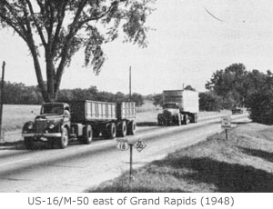
One of six mainline US Highways "decommissioned" in the state of Michigan, US-16 served as the primary highway connection between four of the state's largest cities for nearly four decades. Beginning in downtown Detroit, US-16 headed west-northwesterly via Brighton, Howell, East Lansing, Lansing, Portland and Grand Rapids, arriving in Muskegon where the route continued via railroad carferry across Lake Michigan to Milwaukee.
Historical Overview
The history of US-16 in Michigan actually begins well before the automobile age, dating back to before the European settlers even knew there was a system of Great Lakes and a peninsula jutting north into them. When the Native Americans were the only inhabitants of present-day Michigan, they established footpaths connecting various settlements, hunting areas and fishing locations to each other. What was later termed the "Grand River Trail" was just one of these "Indian trails" to cris-cross the Lower Peninsula. (More Information: External Site)
 As with other "Indian trails," the Grand River Trail was used by the European
settlers arriving in Michigan in the 1830s and '40s, fanning out from Detroit
across the southern Lower Peninsula. The original footpath was gradually
widened, straightened and improved until, around 1850, two plank roads
were constructed linking the state's largest city with its capital. The
Detroit & Howell Plank Road coupled with the Howell & Lansing Plank
Road allowed travellers to (more) easily make the trip between Detroit
and Lansing via Howell. The plank road companies charged a toll to use
the road and toll gates were generally erected every five miles.
As with other "Indian trails," the Grand River Trail was used by the European
settlers arriving in Michigan in the 1830s and '40s, fanning out from Detroit
across the southern Lower Peninsula. The original footpath was gradually
widened, straightened and improved until, around 1850, two plank roads
were constructed linking the state's largest city with its capital. The
Detroit & Howell Plank Road coupled with the Howell & Lansing Plank
Road allowed travellers to (more) easily make the trip between Detroit
and Lansing via Howell. The plank road companies charged a toll to use
the road and toll gates were generally erected every five miles.
The plank roads (sometimes called "turnpikes") did, on average, a mediocre business for several years. However, with the coming of the railroads in the decades following, most of the plank road companies went out of business and the road reverted to public use, usually in a very deteriorated state. This was true for the Grand River Road, as it had come to be called by the later 1800s. It wouldn't be until the second decade of the 1900s that improvements were to again be made to the "Grand River route" through Lower Michigan.
When the Michigan State Highway Department began designating roads throughout the state as "state trunklines" around 1909, one obvious choice was the Grand River Road from Detroit, through Lansing, to Grand Rapids and Lake Michigan. In 1918, after the State of Wisconsin became the first to number and post route markers on its trunkline system, Michigan followed suit as the second jurisdiction to do so. Beginning with "10," routes were numbered sequentially with the seventh numbered route in Michigan being designated "M-16" along the Grand River Road. From 1918 until 1926, this route bore the route markers for M-16 from Detroit to Grand Haven.
Even though several other states had followed Wisconsin's and Michigan's lead during the 1910s and numbered their state highways, several states had not done so and the assortment of the remaining named auto trails had become a jumbled mess. Thus, the US government began a uniform system for marking principal through routes between cities and across state lines—what we know today as the US Highway System. Early planning maps had the route from Detroit through Lansing and Grand Rapids to Grand Haven designated as US-18, but after much "route jockeying" which also saw the routes of US-10 and US-12 swapped in Michigan, the Grand River Road was designated as US-16. The fact the road had been marked as M-16 for the preceeding eight years likely had something to do with the route numbering change to US-16. Michigan's portion of US-16 was only a segment in the entire highway, which stretched through Wisconsin, Minnesota, South Dakota and Wyoming, ending at Yellowstone National Park.
From its debut as a US Highway in 1926, the route of US-16 stayed relatively constant over the next few decades with only minor re-routings as new alignments were built. Two of the more major relocations existed on the highway's western portion. When first designated, US-16 travelled westerly from Coopersville through Nunica, ending in Grand Haven on Lake Michigan. Later, the highway was routed northwesterly from Nunica generally along the alignment of an interurban railway through Fruitport, ending in Muskegon. From there, US-16 continued across Lake Michigan via a railroad carferry to Milwaukee. The second major realignment occurred when all through trunkline routes in Grand Rapids were moved out of the city onto the "beltline system." US-16 then bypassed Grand Rapids to the south and west. For more detailed historical changes to US-16, see the Year-by-Year History section on the next page.
Allan M. Williams (1892–1979), Ionia County Highway Engineer, had a major impact on both US-16 and the overall state highway system, well beyond his day-to-day job helping to design and maintain the roads in Ionia County. In 1929, he introduced the first publicly accessible roadside picnic table on state government right-of-way on US-16 and a historical marker along Grand River Ave south of Saranac denotes this site to this day. Because of this, MDOT installed many hundreds more of these tables in Roadside Parks and Rest Areas across the state and continues maintaining many of these areas today. Williams also helped draft Michigan's first official road map, collaborated in developing the diamond-shaped route marker that bears the designations of state trunkline routes, and pioneered the use of the angled, concave, straight-blade, front-mounted snowplow. But, most notably for US-16 and I-96, according to MDOT notes that "in 1926, Williams cut the opening ribbon for the last paved stretch of improved US-16. In 1977, he was asked to perform the same task for the final section of the successor parallel road, I-96."
 In
the 1950s, US-16 was improved to handle the ever-increasing traffic volumes,
mainly in the eastern part of the state. Even prior to the creation of
the Interstate highway system, the Michigan State Highway Department was
planning a network of controlled-access freeways to cris-cross the state,
connecting the larger population centers. One of the earlier long-distance
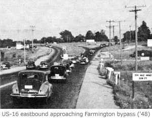
freeways in the state was the "Brighton-Farmington Expressway," connecting
those two cities with a four-lane, divided freeway with access only at
interchanges. A further extension of the freeway from Farmington into downtown
Detroit was planned as the Jeffries Freeway, paralleling US-16/Grand River
Ave the entire way. However, the coming of the Interstate system would
drastically alter these plans.
In
the 1950s, US-16 was improved to handle the ever-increasing traffic volumes,
mainly in the eastern part of the state. Even prior to the creation of
the Interstate highway system, the Michigan State Highway Department was
planning a network of controlled-access freeways to cris-cross the state,
connecting the larger population centers. One of the earlier long-distance
freeways in the state was the "Brighton-Farmington Expressway," connecting
those two cities with a four-lane, divided freeway with access only at
interchanges. A further extension of the freeway from Farmington into downtown
Detroit was planned as the Jeffries Freeway, paralleling US-16/Grand River
Ave the entire way. However, the coming of the Interstate system would
drastically alter these plans.
After President Dwight D. Eisenhower signed the Interstate Highway Act into law in 1956, routes had to be chosen. The Detroit-Lansing-Grand Rapids-Muskegon corridor was an obvious one, however the Interstate designation for this route went through a few changes before finally being designated as I-96 in 1958. The entire length of the Brighton-Farmington Expressway was incorporated into the new Interstate and I-96 route markers likely made their first appearance on the highway in 1959. Over the next five years, additional segments of freeway in the US-16 corridor were built and opened to traffic, being signed concurrently as both I-96 and US-16.
By the end of 1962, however, much of the US-16 corridor had been upgraded to freeway. So as to not have two overlapping route designations on the entire Detroit-to-Muskegon highway, the State Highway Department petitioned the American Association of State Highway Officials (AASHO) to have the US-16 route designation "decommissioned" in the State of Michigan, leaving only the I-96 routing to run between Detroit and Muskegon. AASHO agreed and as of December 12, 1962 the route of US-16 ceased to exist east of Milwaukee, Wisconsin. (In later years, the state departments of transportation in Wisconsin, Minnesota and South Dakota would further "decommission" a majority of US-16 in their states. Today, US-16 only runs from Rapid City, South Dakota to Yellowstone National Park in Wyoming.)
Continues on Page 2: Year-by-Year History & Additional Information