

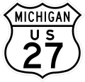
Historic US-27
 On Page 1: Historical Overview
On Page 2: Year-by-Year History | Additional Information
US-27 is the latest mainline U.S. Highway to be decommissioned within Michigan, the sixth of six. However, unlike many of the other decommissioned U.S. Highways, US-27 had not been superseded by an Interstate (or other route designation) over much or all its length. Indeed, it was US-27's own "child route," US-127, which replaced much of it upon decommissioning!
Historical Overview
US-27 is a route that, can be said, developed later in its life and became more important as time went on. Like its westerly and easterly U.S. route neighbors, US-131 and US-23, US-27 was originally designated as a somewhat minor route (relative to other U.S. Highways) up the middle of Michigan's Lower Peninsula, with the only major city it traversed being the state capital of Lansing. As an illustration, the Michigan State Highway Department paved M-78, the route connecting Lansing with Battle Creek, much earlier than it did US-27 south of Charlotte through Marshall and Coldwater.
While other U.S. highways across Michigan received much more attention early on, like US-12 (the Detroit-Chicago route), US-112 (the "other" Detroit-Chicago route via the Great Sauk Trail), US-10 (the Detroit-Flint-Saginaw route), US-25 (the Toledo-Detroit-Port Huron route) and US-16 (the Detroit-Lansing-Grand Rapids route) and were correspondingly upgraded, US-27 developed over the decades into a major north-south route through the state. So much so that the Michigan State Highway Dept petitioned the American Association of State Highway Officials (AASHO) in the late 1950s to remove the proposed Kalamazoo-to-South Bend Interstate and replace it with a northerly extension of I-69 leading northerly from Fort Wayne. This I-69 extension would roughly follow the path of US-27 past Coldwater to Marshall. Soon after, an Interstate extension from Marshall via Charlotte to Lansing was granted and even more of the US-27 corridor found itself on the Interstate system.
From Lansing northerly, US-27 had been improved in the late-1940s and early-50s first to St Johns then on to Ithaca as a divided highway. While this was a great improvement, by the time the upgrades got to Ithaca, the highway department decided to push the improvements one step further and upgrade the route to full freeway standards. Thus, from Ithaca northerly past Alma and St Louis, Mount Pleasant, Clare, Houghton Lake and Higgins Lake, US-27 was built to the new Interstate standards, although a few crossroads remained for a few years until they were removed in the early 1960s.
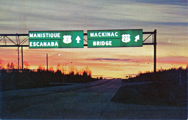 One of the greatest "achievements" for US-27 was being the first route designation to cross the Mackinac Bridge when it opened in November 1957. While US-31 had crossed the Straits of Mackinac via the state auto ferries from 1927 to 1936 or 1939, when the bridge opened to traffic, state highway officials chose to route US-27 over the bridge from Mackinaw City to a new northern terminus at US-2 west of St Ignace. Both US-23 and US-31 terminated at the southern end of the bridge, while US-27 continued northerly over the span on its own. News reports at the time also noted that when the freeway then under construction between St Ignace and Sault Ste Marie was completed, the US-27 designation was to continue north from the Straits, replacing the US-2 designation in that corridor, to the Soo where it would then terminate. The plans to extend US-27 to Sault Ste Marie were apparently dropped by mid-1958, however, as internal State Highway Dept plans showed that US-2 was to be applied to the new freeway along that route alongside the new I-75 designation. Additionally, US-27's time running over one of the state's most recognizable landmarks was, itself, to be rather short-lived. When additional segments of the so called "Ohio-to-Soo" freeway were completed leading northerly and southerly away from the bridge, the I-75 designation was applied to those segments and to the Mackinac Bridge itself. US-27 then ended, once again, along with US-23 and US-31 at the south end of the bridge. But even that was to be short-lived as well.
With the coming of the Interstates, the northern portion of US-27 was unceremoniously "lopped off" in 1961—twice actually. On September 1, 1962, US-27 lost the northernmost 16½ miles of its route when the portion from Mackinaw City southeasterly to Cheboygan was removed from the route it formerly shared with US-23. This new northern terminus for US-27 was short-lived, however, when in December 1962, 81 more miles of the route are removed from Cheboygan southerly through Indian River, Gaylord and Grayling, to a new terminus approximately halfway between Grayling and Higgins Lake in southern Crawford County. Most of the former route from Grayling to Indian River was turned back to local control, while the former US-27 between Indian River and Cheboygan was redesignated as M-27. However, even with the "decommissioning" of US-27 north of Grayling, it is clear the entire corridor was becoming a major traffic conduit.
US-27 remained in its shortened state for approximately forty years while additional upgrades to its route were made. The final segment of freeway between Charlotte and Lansing was completed in 1992 and the long-awaited "St Johns Bypass" freeway opened in segments in 1995, 1996 and 1998, extending the freeway from the Indiana state line to north of St Johns, leaving only about 16 miles of non-freeway between there and Ithaca.
But the US-27 designation was not destined to remain long enough to see these last 16 miles converted to full freeway standards. While the much-appreciated M-57 interchange upgrades were being completed in 2000—thus removing the last traffic signal on US-27 in Michigan—the Michigan Department of Transportation was in the second year of a three-year long process to completely remove the US-27 designation from the state.
An attempt to completely decommission US-27 in Michigan was made by the Michigan Dept of State Highways & Transportation on June 25, 1974, when it, along with the Indiana State Highway Commission, applied to the AASHTO U.S. Route Numbering Subcommittee to have US-27 truncated at I-69 on the north side of Fort Wayne, Indiana. That petition was denied, reportedly because no mention had been made by Michigan as to what was to become of the existing route of US-27 from DeWitt northerly to I-75 near Grayling. It took 17 years before a second petition was submitted by MDOT to the AASHTO subcommittee on August 7, 1991, on the question of US-27 between Fort Wayne and Lansing, although this time, decommissioning wasn't the motivation.
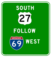 MDOT's 1991 petition to the AASHTO U.S. Route Numbering Subcommittee contained a different approach, one used in some other states called "gap signing." The request was for MDOT and, assumedly, InDOT (although the petition only came from MDOT, so it's not clear how much InDOT was involved in this one), to be able to remove just the US-27 route markers along the concurrently-designated stretch with I-69 from the north side of Fort Wayne, Indiana to DeWitt north of Lansing. Instead, a sign would be erected near DeWitt on southbound US-27 reading "SOUTH US-27 FOLLOW I-69 WEST" and InDOT would erect a similar sign in Fort Wayne on northhound US-27 reading "NORTH US-27 FOLLOW I-69 NORTH." (See map illustrating the scheme.) This type of treatment has been used elsewhere around the country, like Minnesota, while in other states, the state DOT simply "ignores" the concurrent US route—contrary to the AASHTO policies they have agreed to in signing the US Highway System—and only posts whichever routes they choose and disregards others. However, those states either "ignoring" certain US Highway routes or posting the "FOLLOW"-type of signage assumedly do not petition AASHTO to do so, while, in this care, MDOT did ask for approval—but was denied on October 12, 1991. In their response, the AASHTO
 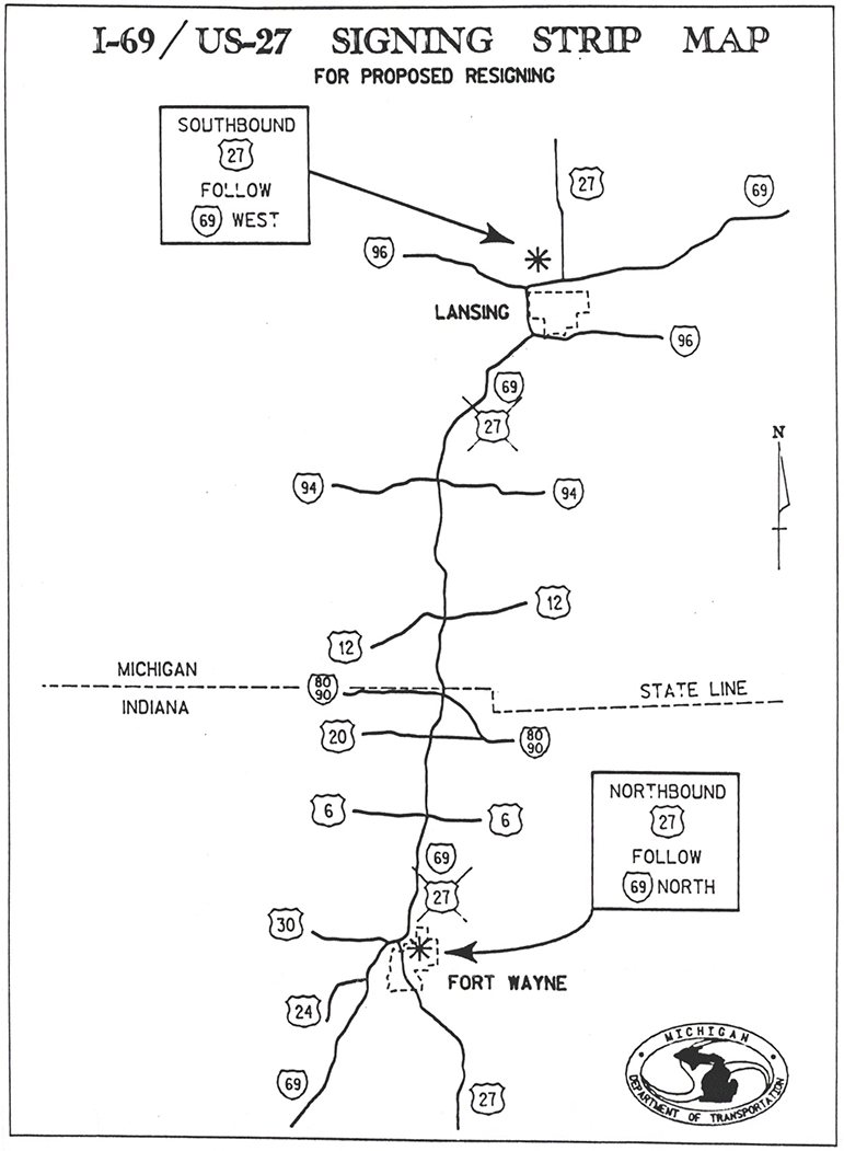 subcommittee cited both the lack of "continuity" in the route and that "U.S. Route numbers may be used in conjuction with Interstate Route markers where the U.S. Route leads into the Interstate Route, follows it for a reasonable distance, an then departs again from the Interstate Route." It seems the AASHTO subcommittee didn't realize MDOT was simply asking to not have to post the signs along that segment, although the route would technically, still be continuous. MDOT's primary reasoning for requesting this approach was the dual signing "is both costly to maintain and confusing to motorists," although proof of the latter hasn't been evident. While slightly wider freeway guide signs are more costly to fabricate, those are only made once every two decades or so, and the "confusion" factor seems rather dubious.
Then, eight years later, MDOT tried for a third time, this time first requesting the US-127 designation replace US-27 from Lansing northerly to Grayling immediately followed by a second request to truncate US-27 from Lansing back to the Indiana state line. (InDOT cooperated and similarly requested a removal of the US-27 designation from I-69 from the Michigan state line southerly to Fort Wayne.) These requests were granted on April 16, 1999. It would take three more years, however, for the changes to actually take place in the field.
During June and July of 2001, MDOT removed most of the US-27 route markers from the route of I-69 from the Indiana state line northerly to the I-69, US-27 & US-127 junction near De Witt, north of Lansing. InDOT did likewise on their portion of decommissioned US-27 between Fort Wayne and the state line. For the moment, US-27 was effectively a two-part discontinuous route running from Miami, Florida to Fort Wayne, Indiana and from Lansing to Grayling. The following year in May 2002, MDOT crews began the complicated process of swapping out every US-27 route marker between Lansing and Grayling and replacing them with US-127 signs. It is estimated well over 500 individual signs needed to be replaced in this process and the total cost to convert US-27 north of Lansing to US-127 has been pegged by MDOT as running in excess of $1 million.
Oddly enough, this process occurred at different times depending on the MDOT region conducting the work. In the Bay and North regions (Gratiot, Isabella, Clare, Roscommon, and Crawford Counties ), the US-27/US-127 swap-out only took a couple weeks in May and was done as quickly as possible. On the other hand, the University Region (Clinton Co) took much longer—nearly the entire summer—to complete the changeover. Thus, for people attempting to follow the route of US-127 indicated on new road maps, the highway "magically" changed route designations near DeWitt to "US-27" and remained as such until south of M-57 where it "magically" became US-127 again!
While few vocal complaints were heard, the need for such a drastic route numbering change and the benefits, if any, derived from the changes, is questionable. A variety of other concepts—from simple and cost-effective to more difficult and costly—have been offered, including:
- Simply "hiding" the US-27 designation along I-69 between Fort Wayne and Lansing. Several states do this, either using the "Minnesota method" whereby a few freeway signs are erected in the appropriate locations instructing motorists "US-27 follow I-69"; or simply ignoring the designation within the I-69 concurrency, such as Utah does. This would be essentially what MDOT proposed doing in 1991, but "just doing it" (as the other states have done) as opposed to pursuing official sanctioning for the action.
- Rerouting US-27 off the I-69 corridor between Tekonsha and Lansing by relocating US-27 onto the route of M-60 between Tekonsha and Jackson, then utilizing the route of US-127 from Jackson to Lansing.
- Rerouting US-27 off the I-69 corridor between Fort Wayne, Indiana and Lansing by relocating US-27 onto the route of US-24 between Fort Wayne and Cecil, Ohio, then utilizing the route of US-127 from Cecil to Lansing.
- Coordinating between the states of Michigan, Indiana and Ohio to completely "swap" the designations of US-27 and US-127 north of Cincinnati.
Continues on Page 2: Year-by-Year History & Additional Information