

| Back to Previous Route: Former M-74 |
 |
On to Next Route: M-75 |
| Southern Entrance: | Ohio state line south of Erie and north of Toledo, Ohio |
| Northern Terminus: | Ontario provincial boundary on the International Bridge between Sault Ste Marie, Michigan and Sault Ste Marie, Ontario |
| Length: | 395.354 miles |
| Maps: | Route Map of I-75 |
| Notes: | I-75 is Michigan's longest route-numbered highway, stretching from Ohio on the south through the entire Lower Peninsula, across the mighty Mackinac Bridge and across the eastern end of the Upper Peninsula, terminating at the Ontario border in Sault Ste Marie. As such, I-75 is often referred to as "Michigan's Main Street." Not only is I-75 a major north-south route in the U.S., it is equally important to commerce and travel within the state of Michigan. On the tourism side, I-75 is the preferred route for Detroiters heading "Up North" on weekends and holidays. Major back-ups regularly occur on southbound I-75 at the end of major summer holiday weekends. |
| In the Metro Detroit area, I-75 is known as the Fisher Freeway from the Downriver area into downtown, then as the Walter P Chrysler Frwy from downtown northerly to the Pontiac area. I-75 is also Michigan's busiest highway, with and average of more than 200,000 vehicles passing over the highway each day between the M-8/Davison Frwy and I-696/Walter P Chrysler Frwy. | |
| The only route designation to currently cross the Mackinac Bridge and the Straits of Mackinac is I-75. Only two other routes crossed the Straits: US-31 did in the 1930s via the state ferries, and US-27 did in the late 1950s when the Bridge first opened. | |
| While several temporary routings of I-75 have existed during the 1960s and '70s in gaps between completed segments, one was longer than the others in both length and existence. Between 1961 and 1973, a rather large gap in I-75 existed between Bay City and US-27 south of Grayling. As this gap was slowly being filled (with the freeway being designated as M-76 in the interim), a temporary routing of I-75 ran northwesterly via US-10 from Bay City to Clare, then northerly via US-27 to the Grayling area. Highway maps of the era, both official and otherwise, showed this routing as "TO I-75" and it has been reported the route was signed similarly in the field (and not using the "TEMPORARY" designation used later on I-69). This route could not be posted as part of I-75 (e.g. without the "TO" signage) as US-27 between Clare and Higgins Lake was only a controlled-access expressway, with intersections at several roads, from 1961 until c.1966. After 1966, US-27 in that area had been upgraded to a full freeway. | |
| In the early 1960s, while the Interstate highway building boom was going full tilt, the program was also suffering a bit of a negative identity crisis. Some were alleging the program was a bottomless pit of waste for taxpayer dollars as some instances of fraud and misappropriation of funds had occurred alongside the building of hundreds of miles of new freeway across the nation. As President John F Kenney took office in 1961, he and those in his administration tried to stem the tide of negative public opinion by initiating several programs to tout the benefits of the new Interstate highway system. One such program was the the weekly supplement to Sunday newspapes, Parade Magazine, cooperating with the Bureau of Public Roads in holding a competition to select America's finest new scenic highways. In an October 1963 issue of Parade, the 22.5-mile segment of I-75 from Vanderbilt to Indian River (part of the so-called "Ohio-to-Soo Freeway" as it was often referred to then) was selected as that year's finest example of a "driver's road" for scenery, speed and safety from across the country. The award was officially called the "Parade Magazine Scenic Highway Award" for 1964, as the selection in late October, 1963 was to be awarded the following year. Unfortunately, the announcement of the selection of this segment of I-75 ended up being pushed aside in many newspapers by the assassination of President Kennedy soon after. | |
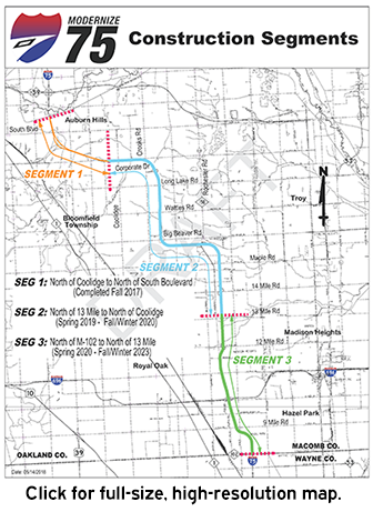 I-75 Modernization Project in Oakland County: With I-75 being the primary north-south freeway running from downtown Detroit northerly and north-northwesterly through the Oakland Co suburbs toward the Flint area and with the highway itself dating to 1962–63 through much of Oakland Co with only spot updates and short-distance reconstruction efforts during its first six decades of service, MDOT began planning for a complete overhaul of the freeway from M-102/8 Mile Rd on the Wayne/Oakland Co line northerly to just south of the M-59 interchange east of Pontiac in the first decade of the 2000s. The FEIS (Final Environmental Impact Statement) was completed in 2005 and the ROD (Record of Decision) was received from the FHWA in 2006. According to MDOT, "The need for increased capacity to relieve congestion is driven by the growth along the corridor due to land use changes and the migration of people, services, and industry. It is a critical commercial, commuter, tourist, and local business route moving people and goods across the state daily." Funding was finally secured and work began on the I-75 Modernization Project in June 2016, which includes widening and rebuilding approximately 18 miles of urban and rural freeway and the implementation of the first high-occupancy vehicle (HOV) lane in Michigan. The first (northern) phase was completed in September 2017, the second (middle) phase was done in late 2020 and the fourth (southern) phase and the entire project was completed in 2023. According to MDOT: I-75 Modernization Project in Oakland County: With I-75 being the primary north-south freeway running from downtown Detroit northerly and north-northwesterly through the Oakland Co suburbs toward the Flint area and with the highway itself dating to 1962–63 through much of Oakland Co with only spot updates and short-distance reconstruction efforts during its first six decades of service, MDOT began planning for a complete overhaul of the freeway from M-102/8 Mile Rd on the Wayne/Oakland Co line northerly to just south of the M-59 interchange east of Pontiac in the first decade of the 2000s. The FEIS (Final Environmental Impact Statement) was completed in 2005 and the ROD (Record of Decision) was received from the FHWA in 2006. According to MDOT, "The need for increased capacity to relieve congestion is driven by the growth along the corridor due to land use changes and the migration of people, services, and industry. It is a critical commercial, commuter, tourist, and local business route moving people and goods across the state daily." Funding was finally secured and work began on the I-75 Modernization Project in June 2016, which includes widening and rebuilding approximately 18 miles of urban and rural freeway and the implementation of the first high-occupancy vehicle (HOV) lane in Michigan. The first (northern) phase was completed in September 2017, the second (middle) phase was done in late 2020 and the fourth (southern) phase and the entire project was completed in 2023. According to MDOT:The project adds a part-time HOV lane in both directions of travel in the northern 14 miles of the corridor, with an additional lane added for capacity in the remaining southern 4 miles. In addition, key components include rebuilding urban and rural freeway segments, vehicular bridges and pedestrian bridges, and ramp improvements along the corridor; additional carpool facilities; utility relocations; improved drainage (including the addition of a 4-mile-long storage and drainage tunnel with a new pump station); upgrades to geometrics, signs, guardrails, median barriers, noise walls, lighting, intelligent transportation systems, and pavement markings; and, enhanced aesthetics. The project is also making operational improvements to all interchanges between north of M-102 to north of the Square Lake Road interchange. |
|
In "State Trunkline Needs, 1960–1980," a set of maps prepared by the State Highway Dept's Office of Planning, Programming Division in 1960 showing possible additions, upgrades and improvements to the state trunkline system over the ensuing twenty years, MSHD staff recommended many changes to the route of I-75 during that timeframe, including:
|
|
| History: | |
| 1956 (April 5) – The first 14 miles of what would (partially) become the Detroit–Toledo Expressway were officially established as a state trunkline highway route in southern Wayne Co, although the portion of the route eventually constructed would not open for another 2½ years. The 14 miles officially established begins at the Huron River Dr interchange (present-day Exit 28) in Rockwood and continues northerly along present I-75 to present-day Exit 35 in Taylor, then continues almost due northerly to intersect the Detroit Industrial Expwy (now I-94) at approximately Pelham Rd, just west of the M-39/Southfield Frwy interchange. | |
Additionally, as the northerly continuation of the Detroit–Toledo Expwy into Wayne Co would not be completed and opened to traffic for another two years, a temporary routing of US-24A is signed to help connect traffic back to the existing routes of US-24 and US-25. From the nothern end of the completed Detroit–Toledo Expwy at Huron River Dr, US-24A continues northeasterly along a newly-complete section of M-85/Fort St to Allen Rd, then along a "Marked and Maintained" route northerly via Allen Rd to West Rd and westerly along West Rd to the jct of US-24/Telegraph Rd & US-25/Dix–Toledo Hwy north of Flatrock. The sections of Allen and West Rds are not officially assumed into the state trunkline system, rather they remain county roads which are signed as trunklines and maintained by the State Highway Dept until replaced by the permanent trunkline route. |
|
| 1957 (Feb) – The Detroit Board of Commerce passes a resolution asking Detroit Mayor Albert Cobo to name the proposed "Hastings-Oakland Expressway" between downtown Detroit and Eight Mile Rd on the northern city limit as the Walter P Chrysler Expwy. | |
| 1958 (Apr 25) – The Michigan State Highway Dept issues a map of "Recommended Numbering, Interstate Highways in Michigan," officially applying the designation of I-75 to its present-day corridor, although the corridor had been anticipated as the future route of I-75 for the past year or two. | |
| 1959 (Jan 30) – The official start of construction on the Walter P Chryler Expwy in Detroit occurs when 12-year-old Jack Forker Chrysler, grandson of the freeway's namesake, pulls the whistle cord on a diesel-powered shovel at groundbreaking ceremonies at near the corner of Hastings St & Macomb St on the eastern edge of downtown. The freeway, estimated to cost $100 million will run from downtown to M-102/Eight Mile Rd along the Hastings St and Oakland Ave corridors and will connect with M-150/Stephenson Hwy which continues northerly into Oakland Co. The first segment, on which construction begins today, is the 3½ mile segment from Jefferson Ave & Randolph St to the Edsel Ford Expwy and is anticipated to cost $54 million. | |
|
|
| 1960 (Nov 11) – The 24 mile portion of I-75 from US-27 north of Indian River (present-day Exit 313) to M-108/Mackinac Tr (present-day Exit 336, formerly US-31) at Mackinaw City in Cheboygan Co is opened to traffic, although this segment of highway will not be officially established as a state trunkline route for just over a year from now (for reasons unclear at this point). Opening ceremonies are held at the Levering–Cheboygan interchange (present-day Exit 326) with State Highway Commissioner John C Mackie the featured speaker and a celebration of local veterans included. This segment of freeway cost $8 million to construct and becomes the first portion of I-75 in Michigan to be opened to traffic only as I-75, and not with a concurrent route designation or first as a different route which is then later redesignated as I-75. The existing route of US-27 from Indian River north-northeasterly to Chebogyan, then northwesterly with US-23 to Mackinaw City remains signed along its existing route. | |
| 1960 (Nov 12) – A 4.1-mile long segment of the I-75/US-2 freeway at St Ignace in Mackinac Co is completed and opened to traffic, beginning at the US-2 interchange at the northern end of the Mackinac Bridge approach (opened in 1957) and continuing northerly through a new interchange for BL I-75 north of St Ignace and merging into the existing segment of freeway that was completed and opened to traffic in Nov 1957. The project cost $4 million to complete. Most of the existing route of US-2 through downtown Saint Ignace is redesignated as BL I-75, while the portion of former US-2 along Mackinac Tr from BL I-75 northerly to the former connection to the 1957 freeway segment remains an unsigned state trunkline highway for four more days. Coupled with the freeway opening the previous day in Cheboygan Co plus the existing five-mile long Straits ot Mackinac Bridge and the portion of freeway between Castle Rock and M-123, this newly-opened section creates a 37-mile long, continuous segment of I-75 running from US-27 north of Indian River (present-day Exit 313) northerly across the Mackinac Bridge to M-123 (at present-day Exit 352). | |
| 1960 (Dec 5)—1961 (Jan 3) |
|
| 1961 (Oct 9) – A short segment of the I-75 freeway is completed and opened to traffic from jct US-27 & M-18/M-76 northerly to the southern Grayling interchange (present-day Exit 254). This section of highway is converted to freeway by constructing a new set of northbound lanes for I-75 to the east of the existing US-27 dvided highway between M-18/M-76 and the south Grayling interchange, while the existing southbound lanes of the former US-27 (constructed in the 1920s) are obliterated and all southbound I-75 traffic is moved over to use the northbound US-27 lanes built in 1955. (The old southbound US-27 lanes are still evident in the present-day as an extended grassy area on the west side of I-75's southbound lanes.) The 4½ miles of former US-27 from the jct of I-75 & M-18/M-76 northerly to the south Grayling interchange are subsumed under the route of southbound I-75. A northerly extension of this short segment of freeway and a southerly connection with the new US-27 expressway past Houghton Lake would open to traffic in less than two months. | |
| 1961 (Oct 27) |
|
| 1961 (Nov 16) – The 4.6 miles of the former route of US-2 along Mackinac Tr from BL I-75 (formerly US-2) at Evergreen Shores north of Saint Ignace northerly to the intersection with the (slightly) relocated M-123 at Rogers Park in Mackinac Co is turned back to local control, four years after most of this segment had been bypassed by a new segment of US-2 freeway (later I-75/US-2, now just I-75). (One MDOT right-of-way map, however, shows that former US-2 along Mackinac Tr in the area of M-123 was turned back to county control on Dec 12, 1960, although that may be an error.) | |
| 1961 (Nov 17, Nov 25) – The 8.5-mile segment of I-75/US-10/US-23 freeway in Saginaw Co beginning at the north end of the "Fenton–Clio Expressway" at Birch Run (present-day Exit 136) and continuing northwesterly to the southern end of the 1949–54 US-23 "Saginaw byass" (designated as US-10/US-23 since the beginning of the year) at Dixie Hwy in Bridgeport at present-day Exit 144 southeast of Saginaw is opened on Nov 17. Instead of the usual ribbon-cutting ceremony, Gov. Swainson participated in a log-cutting ceremony to open the new highway, reminiscient of the Saginaw area's role in the lumbering era a century earlier. This segment of freeway is also officially established as a state trunkline route eight days later on Nov 25. The 8.8-mile former route of US-10/US-23 along Dixie Hwy between Birch Run Rd and the northern end of this segment at Bridgeport is turned back to county control on Nov 25 as well. | |
1961 (Dec 1, Dec 4) – Concurrent with the completion and opening to traffic of the US-27 expressway from Harrison to jct I-75 & M-18/M-76 approximately 6 miles south of downtown Grayling, a 16.7-mile segment of the I-75 freeway is completed and opened to traffic from the south Grayling interchange (present-day Exit 254) in Crawford Co northerly to the Waters interchange (present-day Exit 270) in southern Otsego Co on December 1. Through traffic uses Marlette Rd between the new freeway and the existing route of US-27 to connect with the new freeway segment. The route of former US-27 from the south Grayling interchange through Grayling to M-93/Hartwick Pines Rd north of town is designated as BL I-75. The 12.3 miles of former US-27 from M-93 northerly to the Crawford/Otsego Co line is turned back to local control on December 4. The segment of US- 27 from Waters northerly to north of Indian River is also redesignated as "TO I-75," a temporary designation. It is unclear whether any "TO I-75" route marker assemblies actually went up, or if the old US-27 route markers were just retained for the time being. One map source, however, shows a concurrently designated I-75/US-27 between Grayling and Gaylord and a preserved US-27 routing from there to Indian River in 1962. However, an internal State Highway Dept Control Section atlas from 1962 clearly shows the segment of US-27 from Waters to north of Indian River with the "TO I-75" designation and not as US-27. 27 from Waters northerly to north of Indian River is also redesignated as "TO I-75," a temporary designation. It is unclear whether any "TO I-75" route marker assemblies actually went up, or if the old US-27 route markers were just retained for the time being. One map source, however, shows a concurrently designated I-75/US-27 between Grayling and Gaylord and a preserved US-27 routing from there to Indian River in 1962. However, an internal State Highway Dept Control Section atlas from 1962 clearly shows the segment of US-27 from Waters to north of Indian River with the "TO I-75" designation and not as US-27. |
|
| 1961 (Dec 18) – The 1.4-mile long segment of former US-27 (present-day Old 27) from the Crawford/Otsego Co line northerly to Marlette Rd (temporarily providing access to the completed section of I-75 from Waters, southerly) at Waters is cancelled as a state trunkline route and turned back to county control, over two weeks after the new I-75 segment between Grayling and Waters is completed and opened to traffic. | |
1962 (June 4)
|
|
| 1962 (July 16, July 20) – Beginning at the northern end of the existing I-75 freeway at Waters in southern Otsego Co, a new segment of I-75 freeway opens to traffic on July 16 northerly past Otsego Lake to a new temporary terminus at M-32 on the west side of Gaylord. This segment will not become officially established as a state trunkline highway route, however, until halfway through November. The former route of TO I-75 (formerly US-27) along Old 27 from Waters northerly to M-32 in downtown Gaylord is turned back to local control on July 20. | |
| 1962 (Aug 31) – An 8.8-mile segment of the I-75 freeway is completed and opened to traffic from M-32 on the west side of Gaylord northerly to the former route of US-27 (recently designated TO I-75, present-day Old 27) northwest of downtown Vanderbilt, in Otsego Co. The former 8.89-mile route of TO I-75 (the former US-27) along Old 27 from M-32/Main St in downtown Gaylord northerly to the cnr of Old 27 & Airport Rd northwest of Vanderbilt is turned back to county control and, within Vanderbilt, village control. | |
| 1962 (Oct 25) – The 21½ mile long segment of I-75/US-10 freeway between existing US-10/Dixie Hwy (present-day Exit 93) at Clarkston in north-central Oakland Co and the US-23/Fenton-Clio Expwy (at present-day 115) southwest of Flint is opened to traffic, although it won't be officially established as a state trunkline route for 11–21 days. The State Highway Dept had originally planned to open the entire 33½ mile segment of I-75 from M-24/Lapeer Rd northeast of Pontiac all the way to US-23 southwest of Flint, but delayed the opening of the 11½ segment between M-24/Lapeer Rd and Dixie Hwy until later in the year. The US-10 route markers are removed from Dixie Hwy between Clarkston and the Oakland/Genesee Co line, while the segment of former US-10 through much of Genesee Co is redesignated as M-54. | |
| 1962 (Oct 31, Nov 5) – The new International Bridge linking the twin Sault Ste Maries of Michigan and Ontario and crossing the St Marys River/Soo Locks is completed and the three miles of I-75/US-2 freeway heading southerly away from the bridge to Three Mile Rd is also opened to traffic on Oct 31. The former route of US-2 into downtown Sault Ste Marie is redesignated as BS I-75, with 0.51 mile of Three Mile Rd assumed into the state trunkline highway system between the new freeway and existing US-2 along Mackinac Tr used as the connector between the two routes. The official establishment of the northernmost three miles of the I-75/US-2 freeway occurs on Nov 5, as does the jurisdictional transfer of the 0.51 mile of Three Mile Rd between the freeway and Mackinac Tr. | |
| 1962 (Nov 5, 11am) – The final gap in the route of I-75 in northern Lower Michigan (Grayling to the Straits of Mackinac) is filled when the 22½-mile segment from Old 27 at Vanderbilt (present-day Exit 290) and M-27 north of Indian RIver (present-day Exit 313) is opened to traffic. Additionally, on this date, the entire 66.87-mile route of the I-75 freeway through Otsego and Cheboygan Cos is officially established as a state trunkline highway route from the Crawford/Otsego Co line northerly past Gaylord, Vanderbilt, Wolverine and Indian River to the M-108/Mackinac Hwy interchange (present-day Exit 338) south of Mackinaw City. The actual freeway, however, opened to traffic in sections starting on Nov 11, 1961 (Indian River to Mackinaw City), Dec 4, 1961 (Crawford Co line to Waters), July 16, 1962 (Waters to Gaylord), Aug 31 (Gaylord to Vanderbilt), and Nov 5 (Vanderbilt to Indian River). The 21.86-mile former route of TO I-75 (formerly US-27) from Airport Rd at Vanderbilt in Otsego Co northerly to the southern M-68 jct south of Indian River and from the north jct of M-68 at Indian River northerly to the I-75 & M-27 interchange (Exit 313) north of Indian Rier is turned back to county control on this date as well. The opening of the Vancerbilt-to-Indian River segment of I-75, along with the completion of the Milan-to-Ann Arbor segment of US-23 three days prior, completes a non-stop, four-lane "Ohio-to-Mackinac Expressway" route touted by the State Highway Dept. While a few segments of the route are not yet built up to full freeway standards, there are no traffic signals on the route and only a few at-grade intersections remain. | |
| 1962 (Nov 5–15) – The 33.72-mile long segment of I-75 (and, in part, I-75/US-10) freeway between M-24 northeast of Pontiac and US-23 southwest of Flint is officially established as a state trunkline highway route, although the portion from US-10/Dixie Hwy at Clarkston and US-23 has been open since October 25. The establishment is official in Genesee Co on November 5 and in Oakland Co ten days later on November 15. The remaining 11½ segment of I-75 freeway between M-24/Lapeer Rd and US-10/Dixie Hwy north of Pontiac is still a month away from opening to traffic. The 11.7-mile segment of Dixie Hwy parallel to the new I-75/US-10 freeway, formerly signed as US-10, between Clarkston and the Oakland/Genesee Co line is officially cancelled as a state trunkline route and turned back to County control on November 15 as well. | |
| 1962 (Dec 5) – A 6-mile segment of I-75/US-2 freeway is completed from Tone Rd (present day M-80 at Exit 378) near Kinross to Mackinaw Trail at Dafter in central Chippewa Co. Route markers are removed from the former route of US-2 along Mackinac Tr, which will be jurisdictionally transferred to the county in 1963. | |
| 1962 (Dec 14) – The 11½-mile long segment of I-75 freeway from US-10/Dixie Hwy easterly to M-24/Lapeer Rd north of Pontiac in north-central Oakland Co is completed and opened to traffic, having been established as a state trunkline route a month earlier. | |
| 1963 (July 23) |
|
| 1963 (Oct) – As detailed in the "Notes" section above, the 22.5-mile segment of I-75 freeway completed and opened to traffic the previous year is given the "Parade Magazine Scenic Highway Award" for 1964, selected as the year's finest example of a "driver's road" for scenery, speed and safety from across the country. | |
1963 (Nov 1 11:30am, Dec 5) – The remaining two uncompleted segments of the I-75/US-2 freeway in the Upper Peninsula are completed and opened to traffic on Nov 1 at an opening ceremony at 11:30 am. The 47.81-mile long route of I-75/US-2 from the M-123 interchange at Rogers Park north of St Ignace northerly to the BS I-75/Three Mile Rd interchange on the southern city limit of Sault Ste Marie is officially established as a state trunkline route on Dec 5. Also on Dec 5, the former route of US-2 along Mackinac Tr from M-123 in Mackinac Co northerly to the southern jct of M-48 three miles south of Rudyard, and the former US-2 from the northern jct of M-48 at Rudyard northeasterly along Mackinac Tr to Three Mile Rd at the southern city limit of Sault Sainte Marie is turned back to county control. The two new segments of I-75/US-2 freeway to physically open to traffic are:
|
|
| 1963 (Dec 16) – A short freeway extension is completed north of US-25/Dix–Toledo Hwy north of Woodhaven, connecting into northbound US-24/Telegraph Rd south of Eureka Rd in Taylor Twp (present-day City of Taylor). |
|
| 1963 (Dec 31) – The segment of I-75 through Oakland Co from M-24 northeast of Pontiac, winding southeasterly through Pontiac Twp (present-day Auburn Hills), Troy, Madison Heights and Royal Oak, ending just north of the intersection of 11 Mile Rd & Stephenson Hwy is officially established as a state trunkline route and is likely opened to traffic on the same day. The portion of the parallel M-150/Stephenson Hwy from the new interchange with I-75 in Troy (present-day Exit 67) southerly to 11 Mile Rd in Madison Heights is turned back to local control. The portion of the former M-150/Stephenson Hwy from 11 Mile Rd southerly to M-102/Eight Mile Rd redesignated as a part of a new "TO I-75" (see above). In addition, with the completion of I-75 around the east side of Pontiac, a new BL I-75 routing is created to run through downtown Pontiac and replacing the BUS M-24 designation, beginning at the Square Lake Rd interchange (present-day Exit 75) and ending at the M-24 interchange (present-day Exit 81). | |
1964 (June 12) – A total of 24.55 miles of new state trunkline mileage is officially assumed into the highway system on this date, comprising three sections of the proposed I-75 freeway through the Detroit area. While a short portion of freeway is scheduled for completion within two weeks time, the entire freeway being established today will not be fully completed and opened to traffic for six more years. The three segments include:
|
|
| 1964 (June 26) – The first segment of the Walter P Chrysler Frwy is completed between downtown Detroit at Larned St and I-94/Edsel Ford Expwy north of downtown. The southernmost 1¼ mile is designated as I-375, while the remainder to I-94 is designated as a segment of I-75. | |
| 1966 – The divided highway segment of "TO I-75" running along the former M-150/Stephenson Hwy begins conversion to an urban depressed freeway, with a relocated Stephenson Hwy running along each side of the new I-75 as frontage roads. I-75 traffic (following the TO I-75 route) begins using the new frontage roads while the new freeway is being constructed in between. This new segment under construction runs between M-102/8 Mile Rd & 11 Mile Rd in Hazel Park and Royal Oak. | |
| 1966 (Dec 28) – In southern Wayne Co, I-75 is extended northeasterly for 8 miles from the US-24/Telegraph Rd connector (present-day CONN US-24 at Exit 35) to Schaefer Hwy in southwest Detroit. Construction is underway to connect this new segment with the Walter P Chrysler Frwy north of downtown via a new high-level bridge spanning the Rouge River. |
|
| 1967 (Feb 9) – The 10.54 miles of US-25 in southern Wayne Co from I-75/Detroit–Toledo Expwy north of Woodhaven northerly via Dix–Toledo Hwy, Dix Hwy, Toledo Rd and Oakwood Blvd to M-85/Fort St is turned back to local control, with the US-25 designation transferred onto the I-75/Detroit–Toledo & Fisher Frwys, using M-85/Fort St between I-75 and Oakwood Blvd to rejoin its former alignment at the Rouge River bridge. | |
| 1967 (June 9) – A 0.23-mile segment of Schaefer Hwy in southwest Detroit from M-85/Fort St northwesterly under the I-75/Fisher Frwy to the north end of the interchange (present-day Exit 43) is established as a state trunkline route to provide a full trunkline-to-trunkline connection for M-85 to meet up with I-75 once the portion of M-85 from Schaefer Hwy to Fort St is transferred to local control in five years' time. | |
| 1967 (Oct 5) – The I-75/US-10/US-23 Zilwaukee Bridge spanning the Saginaw River is rammed by the 550-foot freighter J.F. Schoellkopf Jr while the bascule (draw) bridge is in the down (closed) position and open to vehicular traffic. The southbound lanes of I-75/US-10/US-23 are closed and traffic is detoured via M-25 into Bay City, then southerly via M-13 back to the freeway to avoid the closed bridge. The freighter is initially left in place and not removed from under the span for fear that the bridge might collapse. Damaged to the bridge is termed to be "subtantial" in nature. Within days, southbound traffic is rerouted to share the northbound lanes on the bridge while repairs are made to the bridge. | |
| 1967 (Dec 12) – A new portion of the I-75/Fisher Frwy is completed and opened to traffic in southwest Detroit. The segment begins about ½ mile beyond the northern end of the completed freeway at Schaefer Hwy, and proceeds across the River Rouge Bridge, then parallels US-25/Fort St before ending at the Clark St interchange west of downtown. | |
| 1968 (Mar 11) – Repairs to the I-75/US-10/US-23 Zilwaukee Bridge spanning the Saginaw River which was rammed by freighter J.F. Schoellkopf Jr while the bascule (draw) bridge is in the down (closed) position the previous October 5 are completed and the bridge is fully reopened to vehicular traffic, relieving a major traffic issue in the region. | |
| 1968 (Sept 17, 10:00 am) – A 1.3-mile, $7 million portion of the I-75/Fisher Frwy built along Vernor Hwy across the north side of downtown Detroit, is completed between 12th St (present-day Rosa Parks Blvd) and Rivard St where it merges back down into the original Vernor Hwy and a connection with US-25/Gratiot Ave (present-day M-3), although freeway-to-freeway interchanges at BS I-696/John C Lodge Frwy (later US-10, present-day M-10) and I-75/I-375/Walter P Chrysler Frwy will not open to traffic until 1971! Interestingly, the westbound I-75/Fisher Frwy overpass spanning the John C Lodge Frwy is actually the Vernor Hwy overpass constructed in 1953 as part of the original Lodge Frwy project! Additionally, even with this completed segment of the I-75/Fisher Frwy opened to traffic, the TO I-75 designation along M-39/Southfield Hwy-Frwy and M-102/Eight Mile Rd remains, as a gap in the freeway still exists between Clark St and 12th St (present-day Rosa Parks Blvd) in Detroit. | |
| 1968 (Sept 19, 10:00 am) – Ribbon-cutting ceremonies are held to celebrate the completion and opening of a one-mile stretch of the I-75/Walter P Chrysler Frwy in northern Detroit between 7 Mile Rd and M-102/8 Mile Rd. | |
| 1969 (Jan 10) – The final segment of the Walter P Chrysler Frwy within the City of Detroit is completed, when the segment of freeway from I-94/Edsel Ford Frwy to 6 Mile Rd is opened to traffic and designated a part of I-75. This section includes the massive interchange with the Davison Expwy (now M-8/Davison Frwy). (A one-mile portion of this new freeway actually opened early on Dec 19, 1968 between 6 Mile Rd and 7 Mile Rd in Detroit, in order to relieve congestion at that location.) In addition, the first 1½ miles of the new I-75/W P Chrysler Frwy opens north of M-102 along the former alignment of M-150/Stephenson Hwy. The gap in the freeway remains, however, from just south of Woodward Heights to just north of Lincoln Ave in Hazel Park and Royal Oak (and continues to be signed as TO I-75), while another massive interchange is built at 10 Mile Rd. | |
| 1969 (Apr 29) – A brand-new, two-segment, discontinuous 2.05-mile long temporary trunkline route is officially established as a state trunkline route on the west side of downtown Detroit to connect the temporary end of I-75/Fisher Frwy at Clark St with US-10/John C Lodge Frwy in downtown. The purpose of the trunkline is ostensibly to provide a state trunkline connection between the completed portion of the I-75/Fisher Frwy west of downtown and other existing trunkline routes in the downtown core. The first segment runs along Lafayette Blvd easterly from Clark St, crossing over the future route of the I-75/Fisher Frwy (now under construction) and under the Ambassador Bridge, continuing easterly to 12th St (present-day Rosa Parks Blvd), then southerly via Rosa Parks Blvd for one block to US-25/Fort St, where it terminates. The second segment begins at US-25/Fort St 0.4 mile east and continues southeasterly via Cabacier St for one block to Jefferson Ave, then turns easterly via Jefferson Ave for 0.4 mile to the merge with the US-10/John C Lodge Frwy under Cobo Hall. It is currently unclear what this trunkline was signed as in the field–possibly as another "TO I-75" routing. | |
| 1969 – Possibly related to the new temporary trunkline in downtown Detroit (noted above), the TO I-75 designation along M-39/Southfield Hwy-Frwy and M-102/Eight Mile Rd disappears from official road maps for 1969. | |
| 1969 (Aug 5) – All ramps in the Fisher Frwy & Walter P Chrysler Frwy (I-75 & I-375) interchange are open to traffic and motorists are now able to travel between the two freeways for the first time without using city streets for the connection. | |
| 1969 (Sept 15) – All ramps in the I-75/Fisher Frwy & BS I-696/John C Lodge Frwy interchange are open to traffic and motorists are now able to travel between the two freeways for the first time without using city streets for the connection. | |
| 1970 (Sept 17, 10:00 am) – The final portion of I-75 within the City of Detroit is completed with the completion of the Fisher Frwy from Clark St easterly to 12th St (present-day Rosa Parks Blvd), including an interchange with, and the first 3.5 miles of, the Jeffries Frwy (to become part of I-96). I-75 itself now exists in three completed segments (Ohio–Hazel Park, Madison Heights–Bay City, and south of Grayling to Sault Sainte Marie), with TO I-75 routings in between each. | |
| 1970 (Sept 30) – The 2.05-mile long two-segment, discontinuous temporary trunkline route on the west side of downtown Detroit that was established in April 1969, possibly signed as TO I-75, is officially cancelled as a state trunkline route, coinciding with the completion of the I-75/Fisher Frwy through downtown Detroit. It was only in existence for 17 months while the freeway was being completed. | |
| 1971 (Dec 6) – In Metro Detroit, the final segment of I-75/Walter P Chrysler Frwy in Hazel Park and Royal Oak is finally complete and open to traffic and a fully-controlled access urban depressed freeway. Included in this segment is a massive triple-deck interchange at 10 Mile Rd which will accommodate the proposed easterly extension of I-696/Walter P Reuther Frwy across the northern suburbs. Until I-696 is completed, the massive "interchange to nowhere" looks rather out-of-place. | |
| 1971 as ? – A short section of freeway opens from the the south end of the short segment of M-18/M-76 freeway completed in 1970 west of Roscommon to M-18 south of town (from present-day Exit 244 to Exit 239). The project costs $2.58 million to construct. It is unclear if this portion between M-18/M-76 west of town and M-18 south of town is designated as M-76, M-18, "TO M-18" or what. The Official Michigan Highway Maps of the time show M-18/M-76 being retained on the "through-town" routing, with no indication of what the freeway may have been designated, if any. | |
| 1972 (Oct 16) – The 4.08 miles of US-25 running parallel to the I-75/Fisher Frwy from the Fort St interchange (present-day Exit 43) in River Rouge northeasterly to the Clark St interchange (present-day Exit 47) in southwest Detroit along Fort St is turned back to city control. As a result, more of the US-25 designation is transferred to run concurrently with I-75 between those interchanges. US-25 now runs concurrently with I-75 from Dix–Toledo Rd north of Woodhaven to Clark St in Detroit. | |
| 1973 (Sept 26) – The Michigan State Highway Dept announces that now that I-75 is completed and opened to traffic through Detroit, the US-25 designation in Michigan will be discontinued. Michigan and Ohio transportation officials have been considering decommissioning US-25 in both states since 1969. It will be five more months before all US-25 route markers are removed in Michigan. | |
| 1974 (Oct 18) – The 9.45 miles of OLD M-76 bypassed by what is now the I-75 freeway between M-33 at Alger in Arenac Co northwesterly to BL I-75 southeast of West Branch in Ogemaw Co is turned back to local control, four years after the freeway which made the route redundant was opened to traffic. | |
| 1986 (Apr 15) – The 3.24-mile segment of Old 27 and S Otsego Ave between I-75 at Exit 279 south of Gaylord northerly to M-32/Main St in downtown Gaylord is officially (re-)established as a state trunkline route as part of the establishment of a BL I-75 route through Gaylord. (This segment of highway was part of a portion of US-27 cancelled as a trunkline route and turned back to local control in July 1962 with the coming of the I-75 freeway in the area.) From downtown Gaylord, the new BL I-75 is signed concurrently with M-32 along W Main St back to I-75 at Exit 282 on the west side of town. | |
| 1986–87 – The US-10 designation scaled back from downtown Detroit to end at Bay City, removing approximately half its length in Michigan. For I-75, the concurrent US-10 designation between Clarkston and Flint is removed, while the former triple-concurrency of I-75/US-10/US-23 from Flint to Bay City becomes just I-75/US-23. A few random US-10 route markers remain posted along I-75 into the mid-1990s, however. | |
1994 (June 30) – Two short segments of I-75 on either end of the Mackinac Bridge are actually relinquished by MDOT, thereby ceasing to be established state trunkline route segments. When originally established in 1957, records at the time failed to clearly identify jurisdictional, operational and maintenance limits at each end of the Bridge, which had the unintended affect of actually delineating "areas of dual accountability" where both MDOT and the Mackinac Bridge Authority had responsibilities. While these two segments are no longer officially-established trunkline routes, they are still part of the overall route of I-75 (just as the actual Mackinac Bridge structure has been since 1959) and jurisdiction for the highway segments simply moves from MDOT to the MBA. The two segments in question are:
|
|
| 1996 (Aug 1) – Due to a bill signed into law on June 25, 1996 (based on a federal bill signed into law by President Bill Clinton on November 28, 1995 removing the federal restrictions on speed limits on "federally designated" highways), five segments of freeway, including I-75 from Standish northerly to Sault Ste. Marie (excluding the Mackinac Bridge and its approaches), were approved as test stretches to be raised to a 70 mph speed. The speed limit on I-75 from Standish northerly officially increased to 70 on August 1, 1996. | |
| 2016–2023 – The Modernize I-75 Project in Oakland Co reconstructs 18 miles of freeway, upgrading the route from its early-1960s configuration. (See details in "Notes" section above.) | |
| Controlled Access: | The entire route of I-75 is freeway. |
| NHS: | The entire length of I-75 in Michigan is part of the National Highway System. |
| Business Connections: |
|
| Circle Tour: |
|
| Memorial Highways: | The following Memorial Highway designations have been officially assigned to parts of I-75 by the Michigan Legislature:
|
| Photographs: | |
| Continue on: | I-75 into Ohio – via AARoads' excellent website. |
| Weblinks: |
|
| Back to Former M-74 | Route Listings Home | On to M-75 |