

US-31 Freeway in Berrien County
Jump to: History • Freeway Planning Begins • Construction Begins • A Butterly Emerges • Progress Continues • The Long March to Completion • Finally! A Connection to I-94 • Additional Information
The US-31 Freeway in Berrien County was completed on November 9, 2022.
History
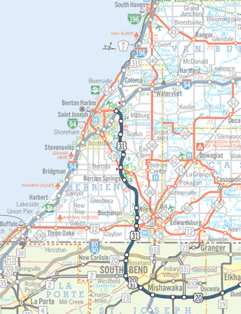
CLICK ON MAP FOR A LARGER VERSION
Map ©2022 Christopher J. Bessert. All Rights Reserved. Please do not copy without written permission.
CLICK FOR A PROGRESS MAP
 The US-31 highway corridor connecting South Bend, Indiana with the Benton Harbor/St Joseph area in Berrien County via Niles and Berrien Springs has always been a major route. In 1926, the corridor became home for one of the brand-new US Highway designations connecting the Indianapolis–South Bend route with the fabled "West Michigan Pike" running along nearly the entire length of the Lower Michigan's Lake Michigan shoreline. The relative importance of this route was underscored in 1938 when the US-33 designation was added from Indiana northerly to Saint Joseph.
When the Interstate Highway System was being laid out during the late 1950s, a route from South Bend, Indiana northeasterly to Kalamazoo was part of the original plans. It was soon determined this corridor was not a good fit into the system, though, and the Michigan State Highway Department asked the federal government to substitute another north-south corridor instead. What resulted was I-69 continuing northerly in the US-27 corridor from the Indiana East-West Toll Road to I-94 at Marshall. However, increasing traffic volumes along US-31/US-33 between South Bend and St Joseph foreshadowed the need for improvements in the corridor at some date. Adding to the volume was the fact that much of US-31 in West and Southwest Michigan was being upgraded to freeway standards, except that portion south of Benton Harbor/St Joseph. To the south, Indiana was also building a westerly bypass of South Bend and the northern end of this freeway was aiming straight at the Michigan state line.
Freeway Planning Begins
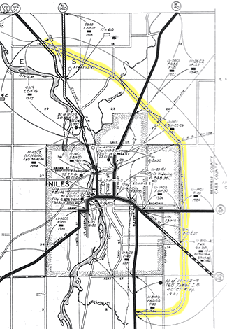 The earliest improvements to the US-31/US-33 corridor south of Benton Harbor and St. Joseph included a proposed eastside bypass of Niles (see image at left) from 1945. Also from the post-World War II timeframe, a close-in bypass of Berrien Springs was also envisioned along the north side of town. However, these bypasses were only to be two-lane, uncontrolled access highways.
As planning for a Niles bypass continued, the State Highway Dept. revised its plans and moved the proposed route much closer in to the city. The eastside bypass was to run along Seventeenth St and tie into the US-112/M-60 (present-day US-12) southern bypass of the city at the "wide spot" in the median near 15th St, east of the present-day M-51 interchange. After traversing the east side of Niles along Seventeenth St, the new route for US-31 was planned to turn northwesterly, cross M-40 (present-day M-51) and the Dowagiac River, then connect into M-140 north of the city. US-31 would then have replaced the M-140 designation through Watervliet and Covert, merging back into its existing route at South Haven. Under these plans, US-33 was to have run alone between Niles and St. Joseph along what had been US-31, then would have supplanted US-31 from St. Joseph northerly along the lakeshore to South Haven.
As the State Highway Dept. began moving forward on its easterly bypass plans for Niles in the 1950s, however, civic officials and local residents mounted a strong opposition, instead preferring a westerly bypass of the city. The westerly bypass, however, would have required at least one crossing of the St Joseph River—two if US-31 bypass plans of South Bend did not bring the highway to the Michigan/Indiana state line already west of the river—thus greatly increasing the cost of the bypass. While local leaders and residents fought the highway department on its Niles bypass plans, another major fight was brewing elsewhere in Berrien Co over the plans for the US-12 "Golden Belt" bypass of the Benton Harbor/St. Joseph area. After explanations from the State Highway Dept. and even congressional hearings on both bypass projects, objection to the US-12 project abated, while contention over the US-31 easterly bypass of Niles only intensified. Finally, on September 29, 1956, State Highway Commissioner Charles Ziegler cancelled the Niles bypass plans and announced a completely new survey on a US-31 bypass of the city to be undertaken in 1958. Ziegler's explanation for the change in plans was that all of the Department's funds for Berrien Co had suddenly become allocated to the US-12 (present-day I-94) freeway running between Stevensville and Watervliet.
The delay in beginning the US-31 bypass of Niles allowed the planning effort by Indiana highway officials for the bypass of South Bend to progress to a point where a westerly bypass for Niles became a de facto conclusion. As early as 1960, State Highway Department planning maps began showing a north-south US-31 freeway bypassing Niles to the west then turning northwesterly past Berrien Springs to an junction with I-94 west of the M-63/Niles Ave interchange at the location of the southern end of the planned St. Joseph "penetrator route." A 1970 report, begun in 1967, prepared by the Department mapped out four possible corridors for a US-31 freeway which touched off a local controversy over how the Village of Berrien Springs would be bypassed—to the west or to the east. The Herald-Palladium noted that, "during a one-year period in 1969–70, the Berrien County Board of Commissioners changed its position three times on which route it favored."
While the first construction on the freeway in Michigan was to have begun in 1975, the State Highway Department delayed that by two years in 1972 due to funding and lack of environmental clearances. Also in 1972, the department issued "Engineering Report No.1803" which established the route for the freeway from Matthew Rd to I-94, including a western bypass for Berrien Springs. This immediately spawned a lawsuit brought by local residents who protested the location. (The state prevailed in the matter and today US-31 bypasses the village to the west.)
Construction Begins
As Indiana continued construction of the South Bend bypass northerly, the Michigan Department of State Highways & Transportation picked up at the state line and began constructing the freeway from there toward US-12 southwest of Niles in 1977. This first segment of the US-31 freeway in Berrien Co was completed and opened to traffic up to US-12 in 1979. From the northern end of the new freeway, US-31 was routed easterly via US-12, then northeasterly via BUS US-12 into downtown Niles, where it met up with its former route and the co-signed US-33. Planning for the next segment of freeway north of US-12 was well underway, although due to funding shortages and economic issues it would be eight years before it was completed.
Meanwhile, with the "Niles bypass" portion of the US-31 freeway under construction, MDOT was in the process of preparing plans for the northerly extension of the freeway past Berrien Springs to an eventual connection with I-94 at the I-196/US-31 interchange northeast of Benton Harbor. Planning for the remainder of the freeway to I-94 began in 1978 and in August 1979, the State Transportation Commission approved the proposed alignment for what was then anticipated to be a $100 million project taking five years to complete. With the proposed alignment selected, the department submitted it to the Federal Highway Administration for review and in 1981 the Final Environmental Impact Statement (FEIS) for the 19-mile segment of freeway was approved by the feds. The long, slow northerly march of the freeway toward I-94 began, although it was not going to be a smooth ride.
With the 1981 FEIS for the route from Matthew Rd northwest of Niles to I-94 northeast of Benton Harbor approved, the "Niles bypass" portion of the freeway was completed and opened to traffic in 1987 from US-12 northerly across the first pair of St Joseph River spans to a temporary terminus at Walton Rd northwest of Niles. The project limits for this portion of the highway were actually at Matthew Rd to the north, but Walton Rd, which was completely rebuilt to state trunkline standards (and rerouted in part), was chosen as the temporary connector between the freeway and the existing two-lane route. While originally not part of MDOT's plans, local business and civic leaders pressured the state into designating a business connection through downtown Niles fearing the loss of revenue from traffic now able to speed past the city instead of being forced to slowly wind their way through as before. The new BUS US-31 was not signed along the previous temporary (1977–1987) route into downtown Niles, however. While US-31 had been signed along BUS US-12/Chicago Dr from southwest of the city into downtown, the new business connection was routed easterly with US-12 to US-33, then northerly with US-33 through Niles instead. With the "Niles bypass" phase of the project completed, the next segment of freeway to begin construction was identified as that portion from Matthew Rd northerly to the existing route of US-31 on the northwest edge of Berrien Springs. This segment would contain the second pair of St Joseph River spans.
Work on the Walton Rd-to-Berrien Springs segment soon began and was completed in 1992. According to area resident Marc Fannin, this segment was opened with two-way traffic on one side of the highway in early November, with the other lanes opening to traffic approximately one week later. Motorists continuing northerly from the Niles area on the new highway expecting a fully controlled-access facility—with a matching freeway speed limit—were to be disappointed, however. The choice was made to complete and open this portion of the route as a limited-access expressway whereby no private access was allowed, but selected crossroads remained as at-grade intersections. Unlike many other states, Michigan speed laws did not make the distinction between an uncontrolled-access two-lane highway and a nearly-freeway quality, limited-access expressway. As such, the speed limit on this new stretch of highway dropped to 55 mph at Walton Rd and remained there to the end of the relocated route at Berrien Springs. Many using the highway found it difficult to keep their speeds down on such a high-quality, "freeway-esque" facility. Others, though, were happy MDOT was able to complete this portion of the relocated US-31 route in only five years and patiently awaited its conversion to full freeway standards. The entire length of the US-31 freeway in southern Berrien Co, as well as across the state line in Indiana, was named the "St .Joseph Valley Parkway" in 1993.
With the Niles-to-Berrien Springs portion of the new US-31 route opened as a 55 mph limited-access expressway, work progressed on this segment in the mid-1990s to convert it to a fully controlled-access freeway. Overpasses were constructed in 1996–97 at most of the intersections—Walton, Range Line, Lake Chapin, Snow and Shawnee Roads and existing US-31—as well as full interchanges at Walton Rd, Snow Rd and existing US-31. However, the speed limit remained at 55 mph for the entire segment north of Walton Rd, as the intersection with Matthew Rd, a minor gravel country lane, remained. The year 1997 also saw the beginning of construction on the third of three pairs of St Joseph River bridges at Berrien Springs as work began on the fourth phase of the freeway to take it from Berrien Springs to Napier Ave east of Benton Harbor.
After six years, Niles-to-Berrien Springs portion of the new US-31 route was finally upgraded to full freeway standards with the completion of the seemingly-unnecessary Matthew Rd overpasses northwest of Niles in 1998. This was the last at-grade intersection north of Walton Rd, meaning the speed limit on this portion of the route could now be raised to 70 mph, the recently-increased maximum rural freeway speed limit in Michigan. These grade separations at Matthew Rd were apparently deemed necessary—and enough to hold up the conversion of US-31 between Niles and Berrien Springs to full freeway standards—by local farmers who demanded their inclusion to preserve access to their fields on both sides of the highway, according to local sources.
A Butterfly Emerges
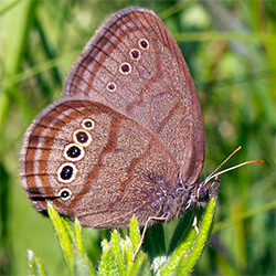 While progress was being made on the southern end of the freeway, the picture was not quite so rosy on the northern end. While the original FEIS for the entire US-31 corridor from Matthew Rd to I-94 had been approved in 1981, the Blue Creek Fen between Benton Center and Millburg was soon after identified as a "unique resource." According to MDOT documents, "the fen provides habitat to many unique species including the Mitchell's satyr butterfly, identified as a Federal Endangered Species in 1991." (For reasons yet unclear, the endangered species first identified in the fen was the Karner Blue butterfly, which at some point was corrected to the Mitchell's satyr.) Because of this, the U.S. Fish & Wildlife Service required MDOT to revise their original plans for crossing the fen and the creek, including the use of long bridges instead of relying heavily on cut-and-fill techniques. After lengthy negotiations between MDOT, the Michigan Department of Natural Resources, the Federal Highway Administration (FHWA), and the U.S. Fish & Wildlife Service, an agreement was reached and the state was again given the go-ahead in the late-1990s to complete the project along the 1981 route, albeit with structural modifications. (In 2001, these modifications included crossing the Blue Creek Fen on two structures, one each northbound and southbound, comprised of two 175-foot approach structures and a 350-foot clear center
span to avoid disturbing the fen itself.)
While progress was being made on the southern end of the freeway, the picture was not quite so rosy on the northern end. While the original FEIS for the entire US-31 corridor from Matthew Rd to I-94 had been approved in 1981, the Blue Creek Fen between Benton Center and Millburg was soon after identified as a "unique resource." According to MDOT documents, "the fen provides habitat to many unique species including the Mitchell's satyr butterfly, identified as a Federal Endangered Species in 1991." (For reasons yet unclear, the endangered species first identified in the fen was the Karner Blue butterfly, which at some point was corrected to the Mitchell's satyr.) Because of this, the U.S. Fish & Wildlife Service required MDOT to revise their original plans for crossing the fen and the creek, including the use of long bridges instead of relying heavily on cut-and-fill techniques. After lengthy negotiations between MDOT, the Michigan Department of Natural Resources, the Federal Highway Administration (FHWA), and the U.S. Fish & Wildlife Service, an agreement was reached and the state was again given the go-ahead in the late-1990s to complete the project along the 1981 route, albeit with structural modifications. (In 2001, these modifications included crossing the Blue Creek Fen on two structures, one each northbound and southbound, comprised of two 175-foot approach structures and a 350-foot clear center
span to avoid disturbing the fen itself.)
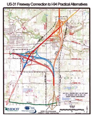 In March 2001 however, with the federal approvals in hand, MDOT began studying alternatives for connecting the US-31 freeway with I-94 in the hopes of finding both a more cost-effective and less environmentally-damaging route. In April, a US-31 Study Team began identifying and mapping so-called "known constraints" within the corridor and created a set of initial "Illustrative Alternatives" presented at a public meeting on July 18. Based on public feedback and additional study, a set of four "Practical Alternatives" were presented at a public meeting on November 6, from which the Draft Supplemental Environmental Impact Statement (DSEIS) was prepared and presented on October 30, 2002. A Final Supplemental Environmental Impact Statement (FSEIS) was prepared, recommending that Practical Alternative Two (PA-2) be designated as the preferred alternative. The 2.5-mile route of PA-2 continues northerly from the current end of the freeway north of Napier Ave, bending westerly and leaving the existing MDOT right-of-way just south of Britain Ave, crossing Benton Center Rd north of Britain and meeting up with I-94 and BL I-94 at a large, new cloverleaf interchange centered on the current Highland Ave overpass spanning I-94.
Progress Continues
Meanwhile, a 9.1-mile long, $97 million extension of the US-31 freeway was completed and opened to traffic on August 27, 2003 from the northern end of the existing freeway at Berrien Springs to Napier Ave east of Benton Harbor. This was the fourth of the five "phases" of the freeway in Berrien Co and removed through traffic off the rather dangerous former route of US-31 between Berrien Springs and I-94. This segment featured the third, and final, pair of St Joseph River spans as well as interchanges at Tabor Rd, Sodus Pkwy (Pipestone Rd relocated) and Napier Ave. This segment of the freeway was actually completed north of the Napier Ave interchange for nearly a mile to just shy of Empire Ave, though all traffic is forced to exit at Napier Ave to connect with the existing route of US-31 along I-94 to the west.
While the routing for US-31 from this temporary terminus of the St. Joseph Valley Parkway freeway westerly to I-94 at Exit 30 used a rebuilt and widened Napier Ave, the roadway itself was identified as a "temporary" state trunkline routing to be used only until the remainder of the US-31 freeway is completed and opened to traffic. However, instead of being a "marked-and-maintained" route—with the local road maintaining agency (county or municipality) having the understanding the roadway segment in question would technically remain under their jurisdiction and only be "marked" as a state highway and "maintained" as such for the duration that it was needed and automatically revert to local maintenance when it was no longer needed for state trunkline connectivity purposes—this "temporary" connector was actually officially established as a trunkline route as part of US-31. This was likely a good thing, as Napier Ave would "temporarily" be a state trunkline route for just shy of twenty years! (However, this meant MDOT had to arrange a jurisdictional transfer agreement with Berrien Co once it was no longer needed, which ocurred in November 2023.)
The Long March to Completion
On October 13, 2004, the Federal Highway Administration issued its Record of Decision (ROD) which approved the location of the selected PA-2 route, connecting the existing US-31 freeway with the I-94 & BL I-94 interchange (Exit 33) east of Benton Harbor. The total cost for this final phase of the freeway in Berrien Co, which will include improvements to the one mile of I-94 between the BL I-94 and I-196 interchanges, was expected to be approximately $60 million. According to news reports, MDOT sources stated project design was to have taken about two years and 19 parcels, mostly farms, needed to be purchased. In late 2002, transportation department sources noted the final segment of the US-31/St. Joseph Valley Pkwy freeway was scheduled for completion in 2006.
One indication of how long the final segment of the freeway was taking to complete was evident in a freeway sign replacement project from 2012. When Napier Ave southast of Benton Harbor became the temporary connector between US-31 and I-94 in 2003, MDOT retain the signs at Napier Ave along I-94 which simply indicated "Napier Ave" at the interchange, while a supplemental sign noted traffic for "US-31 SOUTH – Niles/South Bend" was to use the exist. When the new 2012 signs were installed, the primary signs for the interchange now read "US-31 SOUTH – Napier Ave." Assumedly, MDOT planners and engineers were resigned to Napier Ave being the route of US-31 for long enough to include it on the permanent signage.
According to The Herald-Palladium, in 1975 MDOT had pegged the cost for a freeway from the state line to I-94 in the US-31 corridor to cost approximately $100 million and could be completed by the mid-1980s. In comparison, the Berrien Springs-to-Napier segment completed in 2003 cost nearly that much and the final segment of the freeway to I-94 had not yet been scheduled for construction, although in 2005 its completion had been pegged at "2014 or later." The MDOT 2011–2015 Five-Year Program did specifically note the freeway connection's "design is complete and right-of-way acquisition will continue in 2011" and through 2012.
Finally! A Connection to I-94
While one well-placed transportation planner remarked in the 2010s that the final US-31 freeway connection to I-94 "isn't likely to be completed—ever," in 2016, there was some movement along those lines which greatly intenstified two years later in 2018 when MDOT learned it would receive $20 million in "discretionary grant funding" to complete the freeway connection. The state used its own funding to make up the remainder of the costs and actual construction on the last three miles of the St. Joseph Valley Parkway, 44 years after the first earth movers began their work in Bertrand Township southwest of Niles along the Michigan/Indiana state line.

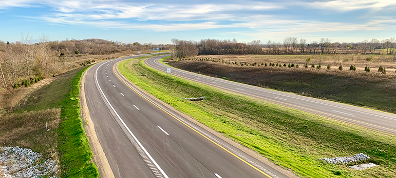
Final segment of US-31 looking northwest from Benton Center Rd overpass, November 8, 2022, the day before it opened to traffic. © 2022 Christopher J. Bessert. All Rights Reserved.
The work to finish the US-31 freeway from Napier Ave to I-94 took two full construction seasons to complete, with a great deal of the work being done along I-94 itself. Not only was I-94 reconstructed and a continuous auxiliary lane constructed between the I-196/US-31 interchange and the new US-31 & BL I-94 a interchange, the Benton Center Rd overpass was rehabilitated and entirely new bridges spanning I-94 at Territorial Rd and Britian Ave were also constructed. BL I-94 itself was reduced from a four-lane, limited-access expressway to a three-lane undivided highway that bends southeasterly east of Euclid Ave to the new I-94 interchange. One major change, however, was the "downgrading" of the proposed full cloverleaf interchange between US-31 and I-94 into a partial cloverleaf. This means the two freeways intersect at a non-freeway interchange. Northbound US-31 traffic ostensibly remains on a controlled-access route, while southbound US-31 traffic must use non-freeway-quality roadway and pass through an at-grade interection (the northbond I-94 on-ramp) to remain on US-31. While the originally-approved full cloverleaf interchange design would have preserved full freeway-to-freeway connectivity, it is assumed this "downgraded" design was substituted to save money, although it remains to be seen if a similar "downgrade" in the level of safety will also accompany the design change.
Beyond the I-94, BL I-94 and US-31 interchange and the many improvements along I-94 itself, the nearly three miles of new US-31 to fill the gap between I-94 and Napier Ave consists of a fully-divided, controlled-access freeway with grade separations at Benton Center Rd and Britain Ave, while a proposed overpass at Empire Ave was eliminated prior to the start of construction to save money. For northbound US-31 traffic, the I-94 & BL I-94"exit" is labeled as LEFT Exit 27.
The final connection was to open to traffic on Saturday, November 5, but weather delays pushed that back to 3:00 pm on Wednesday, November 9, 2022. An "official" ribbon-cutting ceremony and public walking inspection of the new highway had been held in late September to take advantage of better weather conditions. And so, finally, after over nearly fifty years of planning and construction, after over 75 years after the first bypasses had been proposed in the corridor, after endangered butterflies, funding delays and numerous other delays, US-31 is now a freeway throughout Berrien County... well, 99.9% of it is.
US-31 Freeway in Berrien County Progress Map
Final segment of US-31 looking southeast from Benton Center Rd overpass, November 8, 2022, the day before it opened to traffic. © 2022 Christopher J. Bessert. All Rights Reserved.
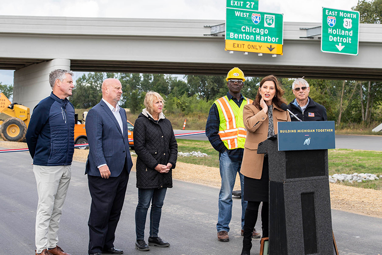
Political leaders at the late-September, 2022 US-31 freeway ribbon-cutting event, including Governor Gretchen Whitmer, U.S. Representative Fred Upton and others. Image courtesy of MDOT.
Many thanks to Marc Fannin who reviewed and contributed valuable input to this article.
Additional Information
- Map of US-31 Freeway in Berrien County – updated November 2022
- US-31 Route Listing
- US-31 Connection to I-94 Study – from MDOT (via archive), giving information on the alternatives and plans for the final phase of the US-31 Freeway in Berrien Co.
- The St. Joseph Valley Parkway and US-31 – a page by Marc Fannin from his Roadfan.com website.
- St. Joseph Valley Parkway Extension – a page documenting the portion of the US-31 freeway opened to traffic in August 2003 by Dan Garnell.