

Historic US-16
 On Page 1: Historical Overview
On Page 2: Year-by-Year History | Additional Information
This page mainly consists of a year-by-year history of US-16, including route realignments, business connections, bypasses and other changes to the route. While US-16 did not exist prior to 1926, included in this listing is the history of M-16, which US-16 supplanted in its entirety. (In essence, M-16 and US-16 could be considered to be the same highway, just with differently-shaped route markers.
Year-by-Year History
| 1918–19 | When the Michigan state trunkline system is assigned numbers and route markers are posted along the routes, the route from Detroit through Howell, Lansing, Portland, and Grand Rapids to Grand Haven is designated M-16. The specific routing is as follows (using present-day road names):
|
| 1924 (Feb 1) |
A new northerly bypass of the community of Okemos in Ingham Co is approved by the Ingham Co Road Commission using the route already survyed by the State Highway Dept. The new route takes M-16 north of downtown Okemos, removes some sharp turns and shortens the overall route by approximately 800 feet. |
| 1924 | The routing in western Clinton and eastern Ionia Cos via Jones, Howe & Peake Rds is turned back to local control when M-16 is routed more directly via present-day Grand River Ave. |
| 1925 | To major realignments occur in 1925:
|
| 1925 | The initial designation for the proposed Detroit-Lansing-Grand Rapids-Grand Haven US Highway is US-18. |
| 1926 | After initially being tagged for the US-18 designation, all of M-16 in Michigan is given the new US-16 route designation from Grand Haven to Detroit. The M-16 route designation will forever disappear from the state, never to be re-used again! |
| 1927 (May 15) |
The new US Highway designations across the state of Michigan officially become effective today, with US-16 superceeding the entire route of M-16 in Michigan, as noted above. |
| 1928 (July 11) |
The Detroit City Council approves the request made jointly by Grover C Dillman, State Highway Dept engineer, and John W Reid, commissioner of public works, to erect route markers on the various streets in downtown Detroit carrying the new U.S. Highway routes. US-16 is to be marked along Grand River Ave from the western city limit southeasterly into downtown to Washington Blvd, then southerly via Washington Blvd to US-112/Michigan Ave, easterly along Michigan Ave to the terminus of US-16 at City Hall. |
| 1930 (June 6) —1933 |
In late 1933, the southern bypass of the City of Farmington is completed via present-day Freedom Rd. The existing route of US-16 through Farmington is retained as a state trunkline. This bypass, sometimes referred to as the "Farmington Cutoff" or the "Grand River Cutoff," is officially approved as a state trunkline highway route on June 6, 1930, but construction takes until 1932 and paving is completed in 1933. The cut-off serves as a two-way bypass around Farmington while existing mainline US-16 continues to traverse the center of the city. |
| 1930 (June 30) |
|
| 1932 (Oct 29) |
|
| 1934 | While not incorporated into the route of US-16, a direct new state trunkline highway between US-16 at Nunica and Muskegon Heights is constructed and opened to traffic as M-126. This new highway alignment, following present-day Apple Dr from Nunica to Fruitport, 3rd St through Fruitport and Airline Hwy from Fruitport into Muskegon Heights. The new highway follows much of the former Grand Rapids, Grand Haven & Muskegon Railway interurban roadbed which had been purchased for highway purposes when the interurban line ceased operations in 1928. |
| 1935 (Aug 15) |
|
| 1936 | The US-16A "Farmington Cutoff" bypass around the city of Farmington in Oakland Co is coverted to one-way service for eastbound traffic only. In the first four years of the existence of the bypass, the cutoff saw 40 deaths. After converting to one-way, the death toll on the bypass for 1937 drops to just one fatality. The existing mainline US-16 route through downtown Farmington continues to serve both directions of traffic. |
| 1937 | The one-way experiment on the US-16A "Farmington Cutoff" bypass around the city of Farmington in Oakland Co is converted back to two-way traffic to accommodate construction on a portion of mainline US-16/Grand River Ave west of downtown Farmington. Plans are to reinstitute one-way eastbound-only traffic on the bypass again once the Grand River Ave work is completed, with plans to improve the bypass route and eventually allow two-way traffic (again) when safety upgrades have been made. |
| 1938 (July 1) |
Even before there is any significant agitation for such a change by Muskegon area civic leaders, it becomes clear the State Highway Dept is likely planning to redesignate the entirety of M-126 as a realignment for US-16, running northwesterly from Nunica throuygh Fruitport and into Muskegon. The "Biennial Report Map" issued by the State Highway Dept as part of its 1936–38 Biennial Report to the Governor and stating "This map shows the status by surface types of the State Trunk Line System as of July 1, 1938" depicts US-16 as having been rerouted to supplant M-126 in its entirety from Nunica through Fruitport and into Muskegon. Interestingly, the same map shows the existing US-16 route from Nunica due westerly through Spring Lake to US-31 at Ferrysburg as having the M-126 designation transferred to it—essentially flip-flopping the two route designations. No route signage changes take place, official highway maps issued to the public do not show any such change, and there are no reports in the media annoucing such a change, so it can be assumed this is the Department "jumping the gun," cartographically, on a route modification that may be coming in the future. |
| 1940 (Apr 9) |
Local civic leaders from the Muskegon area meet with State Highway Commissioner Murray D. VanWagoner to advance several major highway projects in the Greater Muskegon area. Among them is the request to redesignate M-126 from Nunica through Fruitport to Muskegon Heights as US-16A (US-16 Alternate). Redesignating M-126 as an "Alternate" to US-16 would not work since US-16 currently terminates at US-31 in Ferrysburg, 6½ miles south of the western end of M-126, meaning M-126 would not be an alternate routing for US-16, but rather a spur. VanWagoner and the State Highway Dept had already been considering the opposite scenario: replacing M-126 with US-16 and either giving the existing US-16 between Nunica and Ferrysburg a different route designation or possibly making that route US-16A and then continuing US-16A concurrently with US-31 from Ferrysburg back to the relocated US-16 southeast of Muskegon. |
| 1940 (May 31) |
Michigan State Highway Commissioner Murray D. Van Wagoner petitons the American Association of State Highway Officials (AASHO, today's AASHTO) to approve rerouting US-16 from its Nunica-to-Grand Haven alignment to take over the route of M-126 (the "Airline Highway") from Nuncia through Fruitport to Muskegon. The M-104 designation is approved as the replacement for the portion of exisitng US-16 between Nunica and US-31 at Ferrysburg. |
| 1940 (July 1) |
Muskegon and Ottawa Co Road Commission crews, acting on instruction from the State Highway Dept, remove the M-126 route markers along the entire length of the highway, replacing them with US-16 markers. US-16 then continues into downtown Muskegon from the former terminus of M-126 in Muskegon Heights, terminating on the Mart Dock and a connection with the steamships which sail across Lake Michigan and connect with US-16 in Milwaukee, Wisconsin. The US-16 route makers on the former route between Nunica and Ferrysburg via Spring Lake are replaced with M-104 signs at the same time. This brings the existence of M-126 to a close while ushering in the debut of M-104. |
| c.1940–42 | 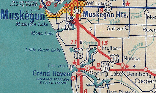 The State Highway Dept apparently commissions a new US-16A or ALT US-16 ("Alternate US-16") routing in the Greater Grand Haven/Ferrysburg/Spring Lake area which, in part, follows the former route of US-16 into the area from the Nunica area. As officially commissioned, US-16A begins at jct US-16 & M-104 at Nunica and runs westerly along M-104 (formerly US-16) through Spring Lake to Ferrysburg, then turns northerly concurrently with US-31 into Muskegon Co, terminating at the jct of US-16 & US-31 southeast of Muskegon. It is unclear if US-16A (or ALT US-16) is ever posted in the field, however, as the designation is never included on any official state highway map and very little is known about the designation. This route designation has only been found on a few internal State Highway Dept maps and only one commercial road map has been found with the route labeled, to date (see map). The reason for the Alternate route may have been to placate Grand Haven/Ferrysburg/Spring Lake-area civic leaders after the loss of the US-16 mainline route. If the route is actually signed in the field, it is decommissioned within a year or two. The State Highway Dept apparently commissions a new US-16A or ALT US-16 ("Alternate US-16") routing in the Greater Grand Haven/Ferrysburg/Spring Lake area which, in part, follows the former route of US-16 into the area from the Nunica area. As officially commissioned, US-16A begins at jct US-16 & M-104 at Nunica and runs westerly along M-104 (formerly US-16) through Spring Lake to Ferrysburg, then turns northerly concurrently with US-31 into Muskegon Co, terminating at the jct of US-16 & US-31 southeast of Muskegon. It is unclear if US-16A (or ALT US-16) is ever posted in the field, however, as the designation is never included on any official state highway map and very little is known about the designation. This route designation has only been found on a few internal State Highway Dept maps and only one commercial road map has been found with the route labeled, to date (see map). The reason for the Alternate route may have been to placate Grand Haven/Ferrysburg/Spring Lake-area civic leaders after the loss of the US-16 mainline route. If the route is actually signed in the field, it is decommissioned within a year or two. |
| 1942 (Spring) | What had been designated M-114 along the South Beltline (now 28th St) and West Beltline (now Wilson Ave) around Grand Rapids is redesignated as BYP (Bypass) US-16. This route has the honor of being the very first US "Bypass" designation in Michigan. Mainline US-16 still travels through downtown Grand Rapids on its existing route. |
| 1948 (Apr 21) |
A new bridge carrying US-16/Grand River Ave over the Huron River and Kent Lake in western Oakland Co, ½ mile east of the Livingston Co line is completed and opened to traffic. The new $193,206 bridge, higher than the one it replaces, will permit the Huron-Clinton Parkway Authority (now the Huron-Clinton Metropark Authority) to raise the level of Kent Lake. |
| 1953 (Summer) | In mid-1953, all of US-16 between the junctions of BYP US-16 in the Greater Grand Rapids area is redesignated as a new BUS US-16 routing. Simultaneously, BYP US-16 is replaced by the mainline routing of US-16 in its entirety. That is a net loss of one BYP US-16 route and a net gain of one BUS US-16 route. |
| 1956 | During mid-1956, the portion of US-16/Grand River Ave in Lansing from jct M-78/Saginaw St on the east side of town to jct US-27/Larch St north of downtown becomes one-way for westbound traffic only and gains the M-78 (westbound) as well. The eastbound US-16 routing now turns south along US-27/Larch St to M-78/Saginaw St, then runs easterly via Saginaw St back to Grand River Ave. |
| 1957 (Aug 15, Dec 13) |
The first four miles of the 22-mile long, $19-million "Brighton–Farmington Expressway" is completed from US-23 on the east side of Brighton to the Livington/Oakland Co line and opens to traffic on August 15. The new freeway, the remainder of which is opened to traffic on December 13, is mostly built on new alignment, although from the Livingston/Oakland Co line to east of Kent Lake Rd the new freeway is built directly atop a portion of Grand River Ave, which is now discontinuous between Kensington Rd and Kent Lake Rd. Also, while it was previously established, the original 1933 "Farmington Bypass" had been converted into the new freeway, new sources show the existing bypass is largely maintained (as Freedom Rd) and the new freeway is built immediately south of the old bypass. The former bypass route is severed, however, at Halsted Rd by the new freeway while the remainder becomes a northerly frontage road for the freeway. The former route of US-16 along Grand River Ave from US-23 at Brighton to the new interchange west of Farmington (at Halsted Rd) is temporarily retained as an unsigned state trunkline as is the former "Farmington Bypass" route via present-day Freedom Rd. Grand River Ave through downtown Farmington is redesignated BUS US-16. |
| 1957 (Aug 20) |
The eastbound lanes of the US-16 "Farmington Bypass" are completed and opened to traffic from Grand River Ave west of Farmington back to Grand River Ave southeast of the city. These first two lanes of the eventual four-lane freeway effectively replace the eastbound-only US-16 "Farmington Cut-off" constructed in the early 1930s. (Westbound US-16 traffic has been forced to travel through downtown Farmington for more than two decades.) The westbound lanes of the "Farmington Bypass" on the US-16 Brighton-Farmington Expwy are still under construction, however. |
| 1957 (Dec 13) |
The remainder of the 22-mile long US-16/Brighton-Farmington Expwy is completed and opened to traffic with ribbon-cutting ceremonies at Brighton, Wixom, Novi and Farmington. The segment from US-23 east of Brighton to the Livingston/Oakland Co line and the "Farmington Bypass" portion had opened to traffic earlier in the year. Steel shortages due to the 1956 steelworkers strike held up completion of over- and underpasses at Wixom Rd and the C&O Railway overpass at Novi. While the new freeway is signed as part of US-16, the former route along Grand River Ave from Brighton to Farmington (with a physical gap at the Huron River at Kent Lake) is retained as an unsigned state trunkline highway route for the time being. |
| 1957 (Dec 24–30) |
Approximately 8½ miles of US-16 freeway are completed and opened to traffic on December 24 from the west side of Coopersville (present-day Exit 16) to just east of Marne (present-day Exit 24) in Ottawa Co, bypassing Coopersville to the south and Marne to the north. From the west end of the new freeway segment west of Coopersville to 40th Ave just east of Coopersville, the former route along Randall St and Ironwood Dr is turned back to local control six days later on December 30, as is the former route bypassing Marne to the south via Berlin Fair Dr and Hayes St. (From 40th Ave east of Coopersville to just west of Marne, the new freeway consumes the original route of US-16.) |
| 1958 (Jan 20) |
An 8½-mile long stretch of US-16 freeway is completed and opened to traffic between existing US-16/Grand River Ave southeast of downtown Portland (at present-day Exit 77), continuing southeasterly and east-southeasterly to the north of the former route past Eagle to M-100 north of Grand Ledge (present-day Exit 86), where the new freeway merges back into exisitng US-16 via a temporary connector roadway. No ribbon-cutting ceremonies are held to mark the opening of the $3.88-million highway, which is opened to traffic six months early. |
| 1958 (Jan 24) |
The 5.85-mile segment of the US-16 freeway in southwestern Clinton Co from existing US-16/Grand River Ave just east of M-100 north of Grand Ledge, northwesterly through Eagle to the Ionia Co line is officially estbalished as a state trunkline highway route, four days after opening to traffic. At the same time, the former route of US-16 along Grand River Ave from just east of M-100 to the Clinton/Ionia Co line is turned back to county control. |
| 1958 (Sept 16) |
The 17.59 miles of the US-16 Brighton–Farmington Expwy in Oakland Co from the beginning of the "Farmington Cut-Off" southeast of Farmington westerly to the Livingston Co line is officially established as a state trunkline highway route. Simultaneously, the 17.1 miles of former US-16 along that same stretch is turned back to local control, specifically the 4.3 miles of the original "Farmington Cut-Off" (Freedom Rd) around the south side of Farmington and the portion of Grand River Ave from Halsted Rd westerly through Novi and New Hudson to the Kent Lake Rd interchange at Kensington Metropolitan Park. |
| 1958 (Dec 18, 11:00 am) |
An additional 20 mile segment of the US-16 freeway across much of Ionia Co is completed and opened to traffic (more then eight months ahead of schedule) from a temporary ramp constructed at Hastings Rd northwest of Clarksville to Portland Rd (present-day Exit 73) west of Portland. A four-mile gap in the freeway between Kent St and Grand River Ave remains, however, on the south side of Portland. Through US-16 traffic is routed from Portland Rd easterly via Grand River Ave (the former route of US-16) back to the freeway southeast of town. The former route of US-16 along Grand River Ave from Hastings Rd to downtown Portland remains an unsigned state trunkline route for the time being. |
| 1959 | A massive new highway project in the Muskegon area creates a 4–6 lane, partially-controlled access "loop route" through the city from the junction of US-16 and the new US-31 bypass southeast of town to north side of the city. This new highway, christened "Seaway Dr," is assigned the US-16 and BUS US-31 route designations. US-16 now enters Muskegon via the new Seaway Dr from the south, then turns northeasterly via Muskegon Ave (wbd) and Webster Ave (ebd) to Sixth St, where US-16 departs US-31 and joins with M-46 running northerly via Sixth St, jogging easterly on Western Ave for a few hundred feet, then northerly again via Mart St to the carferry dock for the over-water journey to Milwaukee, Wisconsin. (The Sixth-Western-Mart routing is not new—it has been part of US-16 since 1941–42.) The former route of US-16 along Airline Hwy (Getty Ave to Peck St), northerly via Peck St, southwesterly via Houston St and northerly one block via Sixth St (Houston St to Muskegon Ave) is turned back to local control. |
| 1959 (June) |
The four-mile gap in the US-16 freeway around the south side of Portland is completed and opened to traffic from Portland Rd west of the city (present-day Exit 73) to Grand River Ave southeast of town (present-day Exit 77). The former route of US-16 along Grand River Ave through downtown Portland remains an unsigned state trunkline route for the time being. |
| 1959 (Nov 4) |
After being severed by the Brighton-Farmington Expwy two years earlier, a new Grand River Ave bridge spanning the Huron River at the outlet of Kent Lake in western Oakland Co is completed and opened to traffic. The original alignment of Grand River Ave at the Huron River was subsumed into the alignment of the new freeway in 1957, thereby causing Grand River Ave to be discontinuous between Livington and Oakland Cos. After complaints from both local residents and business owners, a new alignment for Grand River is constructed immediately to the south of the freeway alignment. |
| 1959 (Nov 13) |
The US-16 freeway is extended westerly from Hastings Rd in western Ionia Co into Kent Co, to a temporarily ending at Whitneyville Ave southeast of Cascade. The temporary connection at Hastings Rd is removed when the freeway to the west is opened to traffic. (M-50 joins US-16 on the new freeway from Alden Nash Ave westerly to Whitneyville Ave.) The former route of US-16 along Grand River Ave (Ionia Co) and Cascade Rd (Kent Co) has its US-16 route markers removed, but remains an unsigned state trunkline—with the exception of the portion between Segwun Ave and Alden Nash Ave near Alto, which becomes part of M-91—for the time being. |
| 1959 (Fall) | |
| 1959 (Dec 7) |
A new US-27 overpass spanning the Chesapeake & Ohio Railway (present-day CSXT) tracks on the north side of Lansing opened to traffic on November 13, removing a dangerous grade crossing on Larch St. As a part of the overpass project, the route of US-16 through the northside of Lansing is altered to actually utilize the new overpass, in part. US-16 enters Lansing from the northwest via W Grand River Ave and at North St previously turned southerly via N Grand River Ave to (the other) W Grand River Ave (not confusing at all), then continued easterly across the north side of Lansing via W & E Grand River Ave (present-day César E Chávez Ave). US-16 now continues easterly via North Ave, which is officially established as a state trunkline route and transferred to state control, from N Grand River Ave to US-27/Larch St. Through Ebd US-16 traffic uses a ramp onto Sbd US-27/Cedar St where it continues south with US-27 for two blocks back to E Grand River Ave, while Wbd US-16 turns northerly from E Grand River Ave and runs with Nbd US-27/Larch St for one block before departing via a ramp to the right that then ducks under the new C&O overpass, merging into North St just west of the railroad tracks. The remainder of North St to the east to Larch St, Larch St (itself formerly US-27 prior to the construction of the overpass) northerly back to US-27 and a long block of Thompson St from a Sbd off ramp from US-27/Larch St southerly to North St are all also made part of the state trunkline system to provide access from Sbd US-27 to Wbd US-16 and from Ebd US-16 to Nbd US-27. The 0.9-mile long former route of US-16 along N Grand River Ave from US-16/W Grand River Ave southerly to (the other!) W Grand River Ave (present-day César E Chávez Ave) as well as W & E Grand River Ave from N Grand River Ave easterly to Sbd US-27/Cedar St are cancelled as state trunkline routes and transferred to city control. |
| 1960 (Mar 7) |
|
| 1960 (May 2) |
|
| 1960 (Aug 23) |
|
| 1961 | The route of BUS US-16 via Grand River Ave through Farmington is redesignated as BL I-96 in its entirety. |
| 1961 (Aug 30) |
|
| 1961 (Sept 18) |
|
| 1961 (Nov 15–25) |
|
| 1961 (Nov 21) |
|
| 1961 (Dec 21) |
|
| 1961 (Dec 22) |
|
| 1962 (July 20) |
Four months prior to opening to traffic, the 5.1 miles of I-96/US-16 freeway from the Eaton/Clinton Co line northwest of Lansing northwesterly to M-100/Wright Rd north of Grand Ledge is officially established as a state trunkline highway route. Simultaneously, the 3.45-mile segment of (soon-to-be former) US-16 along Grand River Ave from the new I-96/US-16 freeway westerly to M-100/Wright Rd is turned back to county control. |
| 1962 (Nov 7) |
|
| 1962 (Nov 10–28) |
|
| 1962 (Dec 10) |
Michigan State Highway Dept crews begin removing US-16 markers along the highway's route, beginning in Detroit on December 10. Full-scale removal of the remaining US-16 signs begins December 12 and is scheduled to take up to two weeks to take down every one of the estimated 1,000 markers. Reassurance markers—those standalone signs generally mounted on signposts on the roadside—will only take a week to be removed, while overhead signage will take the remainder of the time to be eradicated. |
| 1962 (Dec 12) |
|
Additional Information
- Indian Trails – from the Geography Department at Michigan State University.
- Grand River Trail Historical Marker – from the Michigan Historical Markers website.
 End of US highway 16 – from Dale Sanderson's End US Highway website.
 - Current and historic US Highway ends in Detroit – also from Dale Sanderson's End US Highway website.
 US-16 – from the Lowell Area Historical Museum website.
- Do You Remember US Route 16? – from 98.7 WFGR.
- "Grand River Avenue: From Detroit to Lake Michigan" – a book published by Arcadia Publishing as part of its "Images of America" series.