

| Back to Previous Route: M-103 |
 |
On to Next Route: Former M-105 |
| Western Terminus: | US-31 at Exit 104A in Ferrysburg, at the north end of the drawbridge spanning the Grand River immediately north of Grand Haven (see "Connector 104" note below) |
| Eastern Terminus: | I-96 at Exit 9 just west of Nunica in northwest Ottawa Co |
| Length: | 7.233 miles (7.491 miles including Connector 104) |
| Maps: | Route Map of M-104 |
| Notes: | Today's M-104 follows part of the original route of US-16 between Nunica and the Lakeshore in northwestern Ottawa Co. US-16 utilized this route from 1927 until 1940, when it was rerouted to the north via Fruitport to Muskegon replacing the M-126 designation. |
| Connector 104: The precise length of M-104 could be up for discussion due to the existence of Connector 104 in Ferrysburg. As defined by MDOT, Connector 104 consists of the 500 feet of Pine St from M-104 northerly to 3rd St and the 800 feet of 3rd St from Pine St westerly through the US-31 interchange at Exit 104B. The primary reason for the existence of Connector 104 is beause there is no ramp from M-104 to northbound US-31 at the western terminus of M-104. What makes the precise route and length of M-104 unclear is that Connector 104 is fully signed as part of M-104 as opposed to bearing "TO US-31 NORTH" signs westbound and "TO M-104" signs eastbound or even with "CONN M-104" signs like other signed connectors within the state trunkline highway system. As such, the length of M-104 here is shown as the "mainline" route terminating at US-31 Exit 104A coming in at 7.233 miles, while the length including the 0.258-mile long Connector 104 totals 7.491 miles. | |
| The route of M-104 only bears two local road names. From its western terminus at US-31 easterly through the Village of Spring Lake, M-104's name is Savidge St, while the name of the highway in Spring Lake and Crockery Twps is Cleveland Rd. | |
| In "State Trunkline Needs, 1960–1980," a set of maps prepared by the State Highway Dept's Office of Planning, Programming Division in 1960 showing possible additions, upgrades and improvements to the state trunkline system over the ensuing twenty years, MSHD staff recommended just one change to the route of M-104 during that timeframe. With the completion of the I-196/US-16 (now I-96) freeway between Muskegon and Coopersville, the route of M-104 was between the new freeway interchange (present-day Exit 9) and existing US-16/Apple Ave at Nunica was earmarked to be turned back to local control. Just one year later, this occurred as planned. | |
| History: | 1927 (May 19) – A new state trunkline highway route is established beginning in downtown DeWitt in Clinton Co and proceeding easterly via Round Lake Rd into Shiawassee Co at Laingsburg and easterly via Grand River Rd to M-47 (present-day M-52) at Pittsburg. While much of this route is designated as an extension of M-78, the 1.6-mile long spur from jct US-27 & M-78 northeast of DeWitt into downtown is designated M-104. |
| 1929 (April–Aug) – As preparations are made for the proposed Lansing–Flint highway running near Perry, Morrice, Bancroft and Durand to become part of M-78, the existing route of M-78 between US-27 near DeWitt and M-47 (present-day M-52) at Pittsburg is increasingly referred to as "M-104 (M-78)" in media reports. It is unclear precisely when the M-104 route markers are erected and M-78 route markers are removed between US-27 and M-47, however. | |
| 1929 (Dec 2) – The M-78 designation is officially removed from the Lansing–DeWitt–Laingsburg–Pittsburg routing, with the concurrent US-27/M-78 designation north of Saginaw St in Lansing reverting to just US-27. The DeWitt–Laingsburg–Pittsburg trunkline is redesignated as M-104, including the short spur west of US-27 into downtown DeWitt. M-78 is, instead, relocated to a new two-mile long route from Lansing to the western city limit of East Lansing. The length of M-104 increases by 17.5 miles from 1.6 to a total of 19.1 miles in length. | |
| 1938 (Dec 6) – The original 1.6-mile spur route portion of M-104 from US-27 westerly into downtown DeWitt (via Round Lake Rd) is turned back to local control. M-104 now runs 17.5 miles between US-27 near DeWitt and M-47 (present-day M-52) at Pittsburg. | |
| 1939 (Jul 13) – The entire route of M-104, from US-27 northeast of DeWitt to M-47 at Pittsburg via Laingsburg, is turned back to local control, marking the end of the first iteration of M-104. | |
| 1940 (May 31) – Michigan State Highway Commissioner Murray D. Van Wagoner petitons the American Association of State Highway Officials (AASHO, today's AASHTO) to approve rerouting US-16 from its Nunica-to-Grand Haven alignment to take over the route of M-126 (the "Airline Highway") from Nuncia through Fruitport to Muskegon. The M-104 designation is approved as the replacement for the portion of exisitng US-16 between Nunica and US-31 at Ferrysburg. | |
| 1940 (July 1) – Muskegon and Ottawa Co Road Commission crews, acting on instruction from the State Highway Dept, remove the M-126 route markers along the entire length of the highway, replacing them with US-16 markers. (US-16 continues into downtown Muskegon from the former terminus of M-126 in Muskegon Heights, terminating on the Mart Dock and a connection with the steamships which sail across Lake Michigan and connect with US-16 in Milwaukee, Wisconsin.) The US-16 route makers on the former route between Nunica and Ferrysburg via Spring Lake are replaced with M-104 signs at the same time. This brings the existence of M-126 to a close while ushering in the debut of M-104. | |
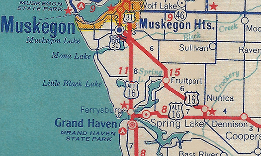 c.1940–1942 – The State Highway Dept apparently commissions a new US-16A or ALT US-16 ("Alternate US-16") routing in the Greater Grand Haven/Ferrysburg/Spring Lake area which, in part, follows the former route of US-16 into the area from the Nunica area. As officially commissioned, US-16A begins at jct US-16 & M-104 at Nunica and runs westerly along M-104 (formerly US-16) through Spring Lake to Ferrysburg, then turns northerly concurrently with US-31 into Muskegon Co, terminating at the jct of US-16 & US-31 southeast of Muskegon. It is unclear if US-16A (or ALT US-16) is ever posted in the field, however, as the designation is never included on any official state highway map and very little is known about the designation. This route designation has only been found on a few internal State Highway Dept maps and only one commercial road map has been found with the route labeled, to date (see map). The reason for the Alternate route may have been to placate Grand Haven/Ferrysburg/Spring Lake-area civic leaders after the loss of the US-16 mainline route. If the route was actually signed in the field—and it may never have been, due to wartime labor and materials shortages—it was decommissioned within a year or two. c.1940–1942 – The State Highway Dept apparently commissions a new US-16A or ALT US-16 ("Alternate US-16") routing in the Greater Grand Haven/Ferrysburg/Spring Lake area which, in part, follows the former route of US-16 into the area from the Nunica area. As officially commissioned, US-16A begins at jct US-16 & M-104 at Nunica and runs westerly along M-104 (formerly US-16) through Spring Lake to Ferrysburg, then turns northerly concurrently with US-31 into Muskegon Co, terminating at the jct of US-16 & US-31 southeast of Muskegon. It is unclear if US-16A (or ALT US-16) is ever posted in the field, however, as the designation is never included on any official state highway map and very little is known about the designation. This route designation has only been found on a few internal State Highway Dept maps and only one commercial road map has been found with the route labeled, to date (see map). The reason for the Alternate route may have been to placate Grand Haven/Ferrysburg/Spring Lake-area civic leaders after the loss of the US-16 mainline route. If the route was actually signed in the field—and it may never have been, due to wartime labor and materials shortages—it was decommissioned within a year or two. |
|
| 1961 (Nov 25) – The route of M-104 is shortened by 0.8 mile when the portion of the route east of the new I-196/US-16 freeway (present-day I-96) to the former route of US-16 at Nunica is transferred to local control. | |
| 1965 (Dec 14) – A new bridge spanning the outlet from Spring Lake between the Village of Spring Lake and the City of Ferrysburg is completed and a short segment of the old route, which is turned back to local control, is bypassed. | |
| Controlled Access: | No portion of M-104 is freeway or expressway. |
| NHS: | The entire route of M-104 is on the National Highway System (NHS). (7.49 miles) (The entirety of M-104 was added to the NHS in 2012 with the passage of the MAP-21 funding and authorization bill.) |
| Memorial Highway: | At present, no portion of M-104 has been designated as part of a Memorial Highway. |
| Photographs: | |
| Weblinks: |
|
| Back to M-103 | Route Listings Home | On to Former M-105 |