| M-135 is a former state trunkline route existing from Early 1929/May 25, 1933 until August 2, 1960. |
| Southern Terminus*: |
US-2 at cnr of Manistique Lakes Rd approximately two miles west of Gould City |
| Northern Terminus*: |
M-28 at jct M-98 approximately 2½ miles southeast of McMillan |
| Final Length*: |
 18.222 miles 18.222 miles |
| Maps: |
Route Maps of Former M-135
Route Map of H-33 |
| Notes: |
* The termini and final length for M-135 reflect the beginning and ending of the route and its length as of the time of its decommissioning in August 1960. |
| |
M-135 was a somewhat minor "lateral" state highway running generally north-south in western Mackinac and southwest Luce Co for its entire existence. After a few realignments over the years, the entirety of M-135 was cancelled as a state trunkline route in mid-1960, but once the Intercounty Highway system was created about 10 years later, the former M-135 was redesignated as H-33. |
| |
In "State Trunkline Needs, 1960–1980," a set of maps prepared by the State Highway Dept's Office of Planning, Programming Division in 1960 showing possible additions, upgrades and improvements to the state trunkline system over the ensuing twenty years, MSHD staff recommended one major change to the route of M-135 during that timeframe: get rid of it. The planners' sole suggestion was to completely transfer the entire route of M-135 to county control. Within months M-135 was decommissioned and this recommendation by the state highway planning staff came to fruition. |
| History: |
1929 (Early) – A new 13.2-mile long highway route in western Mackinac and southwest Luce Co begins showing up on publicly-available maps issued by the State Highway Dept, even though the route itself has not yet been officially established as a state trunkline route. The new highway, designated M-135, runs between US-2 near Gould City northerly through the Curtis area and into Luce Co were it terminates at M-98 at Helmer. It is shown for the next few years as being an "earth" highway, meaning it hasn't even had gravel applied to its surface, and is also noted as being "Impassible" in media reports. |
| |
1933 (May 25) – Four years after first showing up on publicly-issued highway maps issued by the State Highway Dept, the 13.2-mile route of M-135 in Mackinac and Luce Cos is officially established as a state trunkline route. The established route begins at US-2 two miles west of Gould City and proceeds northerly along Manistique Lakes Rd to the Main St–Sandtown Rd intersection southeast of Curtis, turns northwesterly via Main St, then northerly again on Manistique Lakes Rd. At the Luce Co line, the new M-135 turns easterly, then northerly along Kalmbach Rd before bending westerly on Helmer Rd to the shore of Manistique Lake where it then bends northerly via Helmer Rd through the hamlet of Helmer, to a northern terminus at M-98. Construction on the route of M-135 is also completed, adding a graveled road surface. |
| |
1936 (Feb 20) – The 2.8-mile Kalmbach Rd section of M-135 in southwest Luce Co from the Mackinac Co line easterly, then northerly toward Helmer is cancelled as a state trunkline and turned back to local control. Simultaneously, a new 2.2-mile long alignment closer to Manistique Lake from the Mackinac Co line northerly to Helmer Rd is officially established as a state trunkline route. |
| |
1949 (Nov 10) – A 0.3-mile segment of M-135 a Curtis is cancelled as a state trunkline and replaced by a new, 0.2-mile segment which is officially established. It is unclear precisely which segment(s) of M-135 this applies to, however. |
| |
1949 (Nov 19) – The new, direct angling alignment of M-28 from McMillan southeasterly to the East Lake Area in southwest Luce Co is established and likely opens to traffic as well, but the former route of M-28 from the M-98 junction at McMillman Corners northerly 2.4 miles into the community of McMillan is retained as a state trunkline route. The M-135 designation is then extended concurrently with M-98 easterly on Ten Curves Rd, then northerly via Manistique Lakes Rd, easterly again via Bibber Hill Rd, and northerly along Co Rd 365, jogging easterly at McMillan Corners, continuing northerly via McMillan Rd (the former route of M-28) to a new northern terminus at M-28 in "downtown" McMillan. This extends M-135 by approximately six miles. |
| |
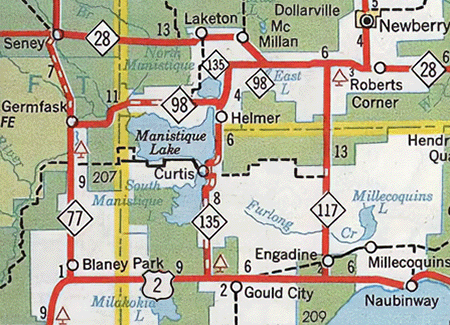 1957 (Dec 1) – Three changes in the route of M-135 are made official today and likely open to traffic about this time as well. The changes, which result in an overall ¾ mile decrease in the length og M-135, include: 1957 (Dec 1) – Three changes in the route of M-135 are made official today and likely open to traffic about this time as well. The changes, which result in an overall ¾ mile decrease in the length og M-135, include:
- The 0.8-mile section of M-135 along Helmer Rd from M-98/Ten Curves Rd southerly through Helmer is cancelled as a state trunkline route and is replaced by a new 0.9-mile route along present-day H-33 which bypasses Helmer and meets M-98 at a new junction northeast of the community.
- The joint M-98/M-135 segment is relocated onto the present-day route of H-33, which is established as a 2.0-mile long state trunkline route running northerly, then gently curving easterly to McMillan Corner. The 2.14-mile long former route of M-98/M-135 running easterly via Bibber Hill Rd and northerly along Co Rd 365 is cancelled and turned back to county control.
- And finally, the 2.4-mile segment of M-135 along McMillan Rd (the pre-1949 route of M-28) from M-98 at McMillan Corners northerly to M-28 at McMillan is cancelled as a state trunkline route and transferred to county control. From McMillan Corners, the M-135 designation now continues easterly with M-98 to a new northern terminus at M-28 near East Lake.
|
| |
1957 (Late) – The various route changes, as noted above, are also accompanied by a project to complete the hard-surfacing of M-135 in Mackinac Co, which now means the entire route is now paved in its entirety. |
| |
1960 (June 30) – A new 40-foot long bridge spanning Portage Creek approximately 1½ miles northeast of Curtis and featuring a 30-foot wide roadway and two 1½-foot sidewalks is completed and opened to traffic. The new bridge is part of an overall project to relocate a segment of M-135 in the area of the stream crossing to eliminate several sharp turns and curves in the route. The new bridge cost $52,100 to construct. |
| |
1960 (Aug 2) – The entirety of M-135 running independently from M-98—the portion from US-2 near Gould City northerly through Curtis to M-98 at Helmer—is cancelled as a state trunkline route and turned back to county control. As such, the formerly concurrent 4.8-mile M-98/M-135 segment becomes just M-98. M-135 has been a state trunkline route for over three decades and the route designation has not been used since. |
| |
1971 – As part of an effort to create and sign a coordinated system of Intercounty Highways, the entirety of the former route of M-135 (1957–1960 version) is designated as H-33. |
| Controlled Access: |
No portion of former M-135 upon decommissioning existed as freeway or expressway. |
| Weblinks: |
|
| |
|