

| Back to Previous Route: M-55 |
 |
On to Next Route: M-57 |
| M-56 is a former state trunkline route existing from September 13, 1913 until Mid/Late, 1966 and from November 10–12, 1971 until December 14, 1984. |
|
| Western Terminus*: | Jct M-13 & M-21 at cnr of Corunna Rd & Sheridan Rd 0.9 mile north of downtown Lennon on the Genesee/Shiawassee Co line |
| Eastern Terminus*: | I-69/M-21/Chevrolet-Buick Freeway in downtown Flint at Exit 136 |
| Final Length*: | 12.763 miles |
| Maps: | Route Map of Former M-56 |
| Notes: | *The termini and final length for M-56 reflect the beginning and ending of the route and its length as of the time of its decommissioning in late 1984. |
There have been two iterations of M-56 over the history of the Michigan state trunkline highway system: one from essentially the debut of the system in 1913 until 1966 (and not "1957," as is stated in Wikipedia by those only consulting Michigan road maps as their only source of information) and the second iteration as an ultimately temporary replacement for M-21 along Corunna Rd and Court St in Genesee Co from 1971 until 1984.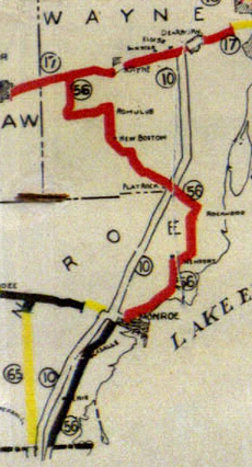 The first M-56 was a bit of a hodgepodge of a route from day one. Trunk Line 56 (T.L. 56) began at the Ohio state line north of Toledo in Monroe Co and continued northeasterly toward Monroe along the Dixie Hwy, what later became US-25 and is now M-125, on a direct alignment straight into Monroe. From there to Rockwood, T.L 56 continued to follow the Dixie Hwy route, which now wound closer to the Lake Erie shoreline instead of the more direct route of Telegraph Rd, which was part of T.L 10. T.L 56 then turns northwesterly and followed a winding route generally running along the Huron RIver corridor through Flat Rock and New Boston to Belleville where it turned due northerly to a terminus at T.L. 17/Michigan Ave about halfway between Wayne and Ypslianti. This entire time, T.L 10 (later M-10) ran largely along the much more direct Telegraph Rd route between the Ohio line and T.L. 17/Michigan Ave at Dearborn, however it took much longer for that route to become improved and paved while M-56 was hard-surfaced early on. As the freeways entered the picture in the late-1940s and 1950s, M-56 gradually became a backwater route and the vast majority of it was incrementally turned back to local control until 1957 when only the portion between downtown Monroe and the I-75 interchange remained and for nine years that last remnant portion would be an odd, little vestige of what was once a much longer route. Finally in 1966, the Dept of State Highways did the logical thing and redesignated the remnant of M-56 at Monroe as a logical extension of M-50, as the two routes terminated at US-25/Monroe St one block apart across the River Raisin from each other. The first M-56 was a bit of a hodgepodge of a route from day one. Trunk Line 56 (T.L. 56) began at the Ohio state line north of Toledo in Monroe Co and continued northeasterly toward Monroe along the Dixie Hwy, what later became US-25 and is now M-125, on a direct alignment straight into Monroe. From there to Rockwood, T.L 56 continued to follow the Dixie Hwy route, which now wound closer to the Lake Erie shoreline instead of the more direct route of Telegraph Rd, which was part of T.L 10. T.L 56 then turns northwesterly and followed a winding route generally running along the Huron RIver corridor through Flat Rock and New Boston to Belleville where it turned due northerly to a terminus at T.L. 17/Michigan Ave about halfway between Wayne and Ypslianti. This entire time, T.L 10 (later M-10) ran largely along the much more direct Telegraph Rd route between the Ohio line and T.L. 17/Michigan Ave at Dearborn, however it took much longer for that route to become improved and paved while M-56 was hard-surfaced early on. As the freeways entered the picture in the late-1940s and 1950s, M-56 gradually became a backwater route and the vast majority of it was incrementally turned back to local control until 1957 when only the portion between downtown Monroe and the I-75 interchange remained and for nine years that last remnant portion would be an odd, little vestige of what was once a much longer route. Finally in 1966, the Dept of State Highways did the logical thing and redesignated the remnant of M-56 at Monroe as a logical extension of M-50, as the two routes terminated at US-25/Monroe St one block apart across the River Raisin from each other.The M-56 designation was only gone from the trunkline system for five years when M-21 was rerouted in western Genesee Co to drop down to the M-78/Chevrolet Frwy at Lennon and follow it easterly into downtown Flint where it continued easterly toward Lapeer. The portion of M-21 between the Shiawassee/Genesee Co line and Flint was was retained as a state trunkline highway route and redesignated as M-56. Less than two decades later, M-21 resumed its former routing into Flint from the west and M-56 was again decommissioned as a route designation and has remained as such since. |
|
| In "State Trunkline Needs, 1960–1980," a set of maps prepared by the State Highway Dept's Office of Planning, Programming Division in 1960 showing possible additions, upgrades and improvements to the state trunkline system over the ensuing twenty years, MSHD staff recommended one thing for the short, remaining segment of M-56 remaining at Monroe during that timeframe: decomissioning and turnback to local control. The reason being is that the State Highway Dept was planning to create a Business Connection for the Monroe Area which would today be a BL I-75 routing. The 1960 proposed Business Connection would have begun at the LaPlaisance Rd interchange, running northerly toward Monroe, turning northwesterly roughly along the Jones Ave corridor to Monroe St, then running through downtown Monroe along Monroe St to approximately Stockton Dr where the route would curve away onto a new-terrain alignment to connect with Greenwood Ave to continue southeaterly (note the wide right-of-way and deep setbacks on Greenwood Ave even today) then again cross-county on a newly-constructed alignment to a terminus at the Dixie Hwy interchange. While this potential/proposed "BL I-75" project has been mentioned several times over the decades, including into the 2000s, there is no indication if the project will ever come to fruition, however, the final segment of M-56 at Monroe—which was redesignated as M-50 in 1966—was finally turned back to local control in 1996 due to the reconstruction of I-75 in the area during that timeframe. | |
| History: | 1913 (Sept 13) – The vast majority of T.L. 56 (Trunk Line 56) is officially established as a state trunkline highway route in Wayne Co (24.2 miles), but not in Monroe Co, although the portion from the Ohio state line northerly to downtown Monroe is likely established as a trunkline route, however the determination has gone missing from State Highway Dept records. As noted above, the route of T.L. 56 begins at the Ohio state line and proceeds northeasterly via Dixie Hwy via Erie and LaSalle and into Monroe along Monroe St. In Monroe, T.L. 56 turns easterly along Elm St, then northeasterly again via Dixie Hwy paralelling the Lake Erie shoreline through Oldport and into South Rockwood to the Wayne Co line. In Rockwood, M-56 follows Fort Rd a short distance then turns northwesterly roughly following the Huron River along Huron River Dr through Flat Rock and New Boston into Belleville. There, T.L. 56 proceeded through downtown Belleville via Main St and then continued northerly along Belleville Rd to T.L. 17 at Michigan Ave where it terminated. While the official determination for the establishment the Ohio-to-Monroe portion of T.L. 56 is missing from State Highway Dept records, it runs along a portion of the "Division 1" as outlined in Public Act 334 of 1913 and, as such, would use May 13, 1913, the approval date of the legislation, as its establishment date. |
| 1918 (Oct 26) – The 0.8 miles of Main St through downtown Belleville between Huron River Dr and Denton Rd—the only poriton of T.L. 56 not yet officially established as a state trunkline route in Wayne Co—is established as a trunkline. | |
| 1919 (July 1) – T.L. 56 is signed in the field as M-56 as all state trunkline highways in Michigan are signed with route markers. | |
| 1920 – The segment of M-56 between the Ohio state line and downtown Monroe disappears from all official (and unofficial) maps from 1920 onward, thereby implying that when state trunkline route markers are placed along Michigan's state highways the year prior, none are erected along M-56 from Monroe southerly. | |
| 1920 (May 20) – The vast majority of the length of M-56 in Monroe Co, the 13.8 miles from the north county line at South Rockwood southerly to the cnr of Dixie Hwy & Elm St in Monroe, is officially established as a state trunkline highway route. The remainder of M-56 into the City of Monroe, while still part of the signed route of M-56, is still under the jurisdiction of the city. | |
| 1927 (May 15) – The portion of what had been originally part of Trunk Line 56 in 1913 between the Ohio state line and Monroe along Dixie Hwy is incorporated into the route of US-25. | |
| 1930 (Dec 8) – The State Highway Dept officially establishes a new state trunkline route bypassing Detroit far to the west through central Oakland, western Wayne and into northern Monroe Co, initially designating this new, proposed route as M-56. This route is, essentially, a direct southerly continuation of the M-15 route from the Clarkston area. In south-central Oakland Co and throughout Wayne Co, the route runs generally along the Haggerty Rd corridor. Simultaneously, the portion of existing M-56 from the west side of New Boston to its northern terminus is officially cancelled as a state trunkline highway route and becomes a "marked-and-maintained" trunkline route until the new "Haggerty Corridor" bypass routing is completed and opened to traffic. Additionally, a 2.0-mile unbuilt connector route is also officially established between the new "Haggerty Corridor" route and M-56 on the west side of New Boston just north of Willis Rd. This would be constructed at the same time the north-south bypass highway is built. (At some point after this, the "Haggerty Corridor" bypass highway between Clarkston in Oakland Co and Future US-23 in north-central Monroe Co northeast of Dundee is redesignated as a southerly extension of M-15.) | |
| 1931 (June 14) – While Act 131 of 1931—the Dykstra Act—is passed on June 14, 1931 allowing the State Highway Dept to take over control of state highways running into and through incorporated cities, thereby officially incorporating them as state trunkline highways, the portion of M-56 leading into Monroe is assumed into the trunkline system on October 29, 1932. This involves the 0.89 miles of Elm St from Dixie Hwy to US-25/Monroe St. Now all of M-56 is under State Highway Dept jurisdiction. | |
| 1935 (Jan 7) – After 4½ years of no progress, the proposed far west M-15 Detroit bypass along the "Haggerty Corridor" alignment is officially cancelled without ever have been constructed, including the never-built M-56 "connector" between the bypass route and New Boston. Interestingly, existing M-56 from New Boston northerly and westerly to Belleville and then northerly to its terminus at US-112/Michigan Ave (present-day US-12) is not immediately re-established as a state trunkline route and remains a "marked-and-maintained" route for the time being. | |
| 1939 (July 13) – The 13.0 miles of "marked-and-maintained" M-56 from New Boston through Belleville to US-112/Michigan Ave is again re-established as an official state trunkline highway route. | |
| 1943 (Feb 26) – The portion of M-56 between the new Willow Run Expressway connector (present-day Northline Rd) and the intersection of M-112/Willow Run Expwy & Bellville Rd is cancelled as a state trunkline route and turned back to local control. Instead of running through Belleville, M-56 is rerouted off Huron River Dr up the Willow Run Expwy connector to M-112/Willow Run Expwy, then westerly concurrently with M-112 along the Willow Run Expwy for three miles back to existing M-56 at Belleville Rd. | |
| 1954 (Sept 7) – All of M-56 from the C&O Railway crossing on the east side of New Boston in Wayne Co northwesterly is cancelled as a state trunkline higway route and turned back to local control. This includes Huron River Dr beginning at the C&O Ry crossing east of New Boston to the second Northline Dr intersection west of Romulus, then northwesterly along Northline Dr to M-112/Willow Run Expwy, as well as the segment of M-56 along Belleville Rd from M-112/Willow Run Expwy to US-112/Michigan Ave. | |
| 1956 (Apr 27) – The 7.2 miles of M-56 along Huron River Dr from the C&O Railway crossing on the east side of New Boston southeasterly to the northwestern limits of the City of Flat Rock are cancelled as a state trunkline route and turned back to county control. | |
| 1957 (Apr 3) – An additional 4.5 miles of M-56—the remainder of the route in Wayne Co—is cancelled as a state trunkline highway route and turned back to local control, starting at the northwestern corner of Flat Rock and continuing southeasterly into Rockwood along Huron River Dr, then southwesterly to the Monroe Co line at the Huron River bridge, | |
| 1957 (June 17) – The 12.3 miles of M-56 along Dixie Hwy from the Wayne/Monroe Co line at South Rockwood southerly and southwesterly to the interchange at US-24A/Detroit-Toledo Expwy (present-day I-75) is cancelled as a state trunkline highway route and turned back to county control. The only portion of M-56 remaining is the segment from US-25/Monroe St in downtown Monroe to the US-24A/Detroit-Toledo Expwy interchange, a total of 2.509 miles in length. | |
| 1966 (Summer/Fall) – At some point during the last half of 1966, all route markers along the 2½ mile remaining segment of M-56 are swapped out for M-50 markers, signalling the end of the first iteration of M-56 after 53 years. | |
| 1971 (Nov 10–12) – In a reversal of their 1967 annoucement that M-78 will replace the M-21 designation from Flint to Port Huron as the new freeway through Flint and between those cities is opened to traffic, the Dept of State Highways announces M-21 will be rerouted to run along the entirety of the Chevrolet Freeway in Genesee Co and continue east to Port Huron as it has since the early days of the Michigan state trunkline system. M-21 coming easterly from Owosso now turns southerly concurrently with M-13/Sheridan Rd through Lennon to the M-78 freeway (present-day I-69 Exit 123) where it turns easterly, joining the M-78 designation on the Chevrolet Frwy past Swartz Creek into Flint. The former route of M-21 along Corunna Rd between M-13/Sheridan Rd and Court St and on Court St from Corunna Rd to M-54/Dort Hwy is redesignated as M-56. All route markers involved in the route changes are posted by November 12. This marks the debut of the second iteration of M-56. | |
| 1972 (Sept 15) – The segment of Beach St in downtown Flint between M-56/Court St and W Ninth St (the wbd M-78/M-21/Chevrolet Frwy service drive) is officially established as a state trunkline route and transferred from city to state control. Beach St is one-way southbound and serves as the easternmost end of the route of M-56, even though Court St is a state trunkline through the future I-475 interchange. At its eastern end, eastbound M-56 traffic turns southerly from Court St via Beach St to a terminus at W Ninth St (the wbd M-78/M-21/Chevrolet Frwy service drive), while for westbound M-56 traffic, the route begins at W Ninth St & S Saginaw St and continues northerly concurrently with BUS M-54 along S Saginaw St to Court St where it turns westerly via Court. (Interestingly, Saginaw St is a two-way street, even though sources indicate only westbound M-56 is routed along it at this time, with eastbound using southbound Beach St.) |
|
| 1972 (Sept 22) – The 1.439 miles of E Court St from Future I-475 easterly to M-54/Dort Hwy, formerly part of M-21, are cancelled as a state trunkline highway route and turned back to city control. While several internal Dept of State Highways maps indicate this segment was included in the redesignation of M-21 to M-56 the previous November, M-56 route markers may not have been erected on this portion east of Future I-475 prior to the jurisdictional transfer. Due to the Beach St jurisdictional transfer eight days earlier, it can be assumed the signed route of M-56 now uses Beach St southbound for M-56 ebd and Saginaw St northbound for M-56 wbd between Court St and the M-78/M-21/Chevrolet Frwy. | |
| 1974 – BUS M-54 is decommissioned as a signed highway route through Flint along Saginaw St between M-54/Dort Hwy intersections. If M-56 had not yet been signed between Court St and the M-78/M-21-turned-I-69/M-21/Chevrolet Frwy (M-78 from Olivet to Flint is replaced by I-69 in February 1974), it is now, as the BUS M-54 markers are removed from S Saginaw St between Court St and W Ninth St. | |
| 1976 (Sept 29) – The "Fifth St Extension" on the west side of downtown Flint is completed and opened to traffic with eastbound M-56/Court St traffic diverted to the new 5th St extension where it departs Court St west of Ann Arbor St, resulting in the conversion of Court St between that point and Beach St to westbound only travel. Even though ebd M-56 traffic now uses Fifth St into the downtown core, it has not yet been officially transferred to state control. The final touches on the project will run into late October. | |
| 1977 (July 23) – Fifth St in downtown Flint, converted into the eastbound half of a one-way pair for M-56 through the central city (with Court St being retained as the westbound side of M-56) is officially established as a state trunkline route and transferred to state control, ten months after it was opened to traffic. At this point, ebd M-56 enters downtown Flint on W Court St, then veers southerly onto the "Fifth St Extension" and uses the one-way ebd Fifth St to Beach St where it resumes its former route by turning southerly via one-way sbd Beach St to M-56's terminus at W Ninth St at I-69/M-21 Exit 136. Wbd M-56 remains along S Saginaw St from W Ninth St northerly to Court St, then westerly along one-way wbd W Court St until it meets the Fifth St Extension. | |
| 1981 (Sept 7) – With the completion and opening of I-475/UAW Freeway between E Court St and N Saginaw St near Mount Morris, both E Court St and E Fifth St from Saginaw St to nbd Lewis St (present-day nbd Chavez Dr, the nbd I-475 service drive)—still unsigned state trunkline routes from when M-21 continued east from downtown Flint via Court St to M-54/Dort Hwy ten years prior—is now an "M-56 connector," whether signed or not is unclear. It may have had "TO M-56" route marker assemblies or it may have remained an unsigned trunkline route. | |
| 1984 (Dec 14) – The entire 39-mile segment of freeway from Lapeer to Wadhams opens, not as M-21, but rather as an easterly extension of I-69. The length of M-21 is scaled back by approximately 70 miles from Port Huron to end in Flint. The M-56 designation which had replaced M-21 along Corunna Rd, Miller Rd and Court St between M-13/Sheridan Rd and the I-475/UAW Frwy in downtown Flint in 1971 is replaced, ironically, by a rerouted M-21. The former M-13/M-21 through Lennon reverts back to just M-13, while the concurrently-designated M-21/I-69 between Lennon and Flint becomes just I-69. As of this date, M-56 ceases to exist as a state trunkline designation in Michigan. | |
| 2004 (Feb 6) |
|
| Controlled Access: | No portion of M-56 was freeway or expressway. |
| Photographs: |
|
| Weblinks: |
|
| Back to M-55 | Route Listings Home | On to M-57 |