| Western Terminus: |
M-15 two miles west of Munger |
| Eastern Terminus: |
M-24 two miles east of Akron (cnr of Unionville Rd & Akron Rd) |
| Length(s): |
20.154 miles |
| Maps: |
Route Map of M-138 |
| Notes: |
 M-138 is a secondary state route traversing a mostly agricultural region in the westernmost portion of Michigan's Thumb with farming having long been the dominant industry with the area being very flat and having fertile soil. Because of this, shipping harvested crops and products made from them is an important activity and usually requires an All-Season rated highway for the heavy trucks to operate. While M-138 historically was not an All-Season roadway, three segments have been upgraded in support of the area's farming industry: From M-15 easterly through Munger in Bay Co and in Tuscola Co from Fairgrove westerly for a few miles and from Akron easterly to M-24, which was constructed/re-constructed specifically to provide All-Seasons access to the region in the 1990s. M-138 is a secondary state route traversing a mostly agricultural region in the westernmost portion of Michigan's Thumb with farming having long been the dominant industry with the area being very flat and having fertile soil. Because of this, shipping harvested crops and products made from them is an important activity and usually requires an All-Season rated highway for the heavy trucks to operate. While M-138 historically was not an All-Season roadway, three segments have been upgraded in support of the area's farming industry: From M-15 easterly through Munger in Bay Co and in Tuscola Co from Fairgrove westerly for a few miles and from Akron easterly to M-24, which was constructed/re-constructed specifically to provide All-Seasons access to the region in the 1990s. |
| |
An extension of M-24 between Caro and Unionville was completed in 1997. Plans were to have the M-24 designation replace the M-138 designation along Unionville Rd between Akron Rd and M-25 in Unionville. However, the 1997 and 1998 Official Michigan Highway Maps showed M-138 still running along that route with M-24 ending at M-138. Through a field checking trip, the reality is that M-138 now ends at M-24 (cnr Unionville Rd & Akron Rd) two miles east of Akron and M-24 continues northerly via the former M-138/Unionville Rd into Unionville. The 1999 highway map correctly shows this change. |
| |
Prior to the completion of the M-24 extension from Caro to Unionville, M-138's total length was 26.151 miles. |
| History: |
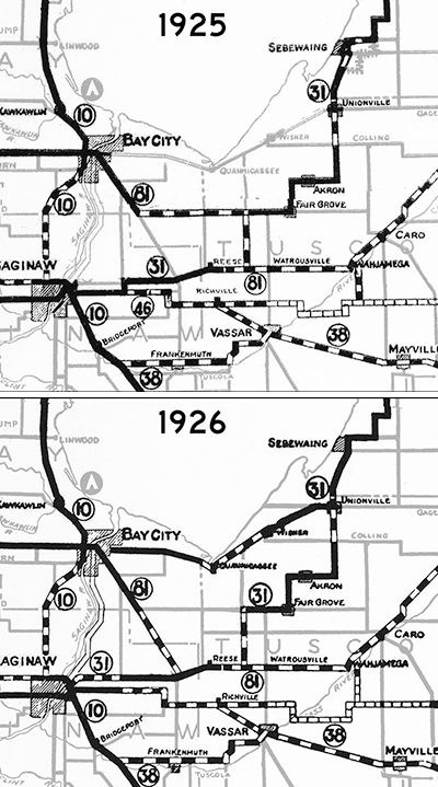 1914–30 1914–30  – M-138 has its beginnings as parts of two other trunkline routes dating from 1914 and 1920 and a confusing array of highway route changes from that time until 1930. The east half of today's M-138 debuts on March 23, 1914 as part of the route of T.L. 31 (Trunk Line 31) which runs from Saginaw through Reese, Fairgrove, Akron, Unionville, Sebewaing, Pigeon, and Bad Axe to Harbor Beach on Lake Huron. The western half dates to March 5, 1920 when T.L. 81 (Trunk Line 81) is established running from Bay City through Munger, Watrousville, Caro and Cass City to T.L. 53 in Sanilac Co. (Northeasterly-trending T.L. 31 and southeasterly/easterly trending M-81 share a five-mile stretch of roadway along Bradleyville Rd through the hamlet of Gilford in western Tuscola Co—see map at right.) In 1926, M-81 is redirected to run southeasterly along the present-day route of M-15, then easterly toward Caro, however the stretch of highway from present-day M-15 south of Bay City easterly through Munger to Bradleyville Rd remains an established state trunkline route, albeit one without a route designation. – M-138 has its beginnings as parts of two other trunkline routes dating from 1914 and 1920 and a confusing array of highway route changes from that time until 1930. The east half of today's M-138 debuts on March 23, 1914 as part of the route of T.L. 31 (Trunk Line 31) which runs from Saginaw through Reese, Fairgrove, Akron, Unionville, Sebewaing, Pigeon, and Bad Axe to Harbor Beach on Lake Huron. The western half dates to March 5, 1920 when T.L. 81 (Trunk Line 81) is established running from Bay City through Munger, Watrousville, Caro and Cass City to T.L. 53 in Sanilac Co. (Northeasterly-trending T.L. 31 and southeasterly/easterly trending M-81 share a five-mile stretch of roadway along Bradleyville Rd through the hamlet of Gilford in western Tuscola Co—see map at right.) In 1926, M-81 is redirected to run southeasterly along the present-day route of M-15, then easterly toward Caro, however the stretch of highway from present-day M-15 south of Bay City easterly through Munger to Bradleyville Rd remains an established state trunkline route, albeit one without a route designation.
Then in 1927, with the coming of the U.S. Highway System and the many route designation changes it causes statewide, M-31 is redesignated as a rerouted M-81 westerly from Reese into Saginaw, while the remainder of M-31 is redesignated as M-84 from M-81 through Fairgrove and Akron to Unionville, as part of M-29 from Unionville to Bay Port, and as M-83 from Bay Port through Bad Axe to Harbor Beach. By early 1929, M-84 is replaced in its entirety by a southwesterly extension of M-83 from Bay Port to Unionville, then via Akron, Fairgrove and Gilford to M-81, then west along M-81 before turning southerly in Saginaw Co to run to M-38 at Frankenmuth.
For four years from 1926 until mid-1930, the east-west trunkline route from M-24 (present-day M-15) easterly through Munger to Bradleyville Rd has been an officially-established trunkline without a route designation. This changes by mid-1930 when it begins appearing on State Highway Dept maps as M-138. |
| |
1930–31 – Internal State Highway Dept maps start showing the un-numbered and assumedly unsigned trunkline route from M-24 (present-day M-15) easterly through Munger to M-83 at the cnr of Fairgrove & Bradleyville Rds with the M-138 designation. By the start of the next year, M-138 is now shown on publicy-distributed State Highway Dept maps, indicating the route is likely signed in the field by this point. |
| |
1939 (Jul 13) – The portion of M-83 along Bradleyville Rd between M-81 and M-138 is cancelled as a state trunkline route and transferred to county control, thereby severing M-83 into to parts, with the southern segment retaining the M-83 designation. The portion of M-83 in Tuscola Co via Fairgrove Rd easterly from M-138 to Fairgrove, then northerly via Hinson Rd to Akron Rd, easterly via Akron Rd through Akron to Unionville Rd, then northerly via Unionville to M-25 in downtown Unionville becomes an extension of M-138. With this extension, M-138 reaches is "classic routing" which would remain static for almost six decades. |
| |
1940 – The last segment of gravel-surfaced M-138, from the Bay/Tuscola Co line easterly to Bradleyville Rd, is hard-surfaced. |
| |
1989 (July–Aug) – The first phases of a project to extend M-24 from Caro to M-25 at Unionville is completed and opened to traffic—nearly nearly 30 years after the extension was first discussed and nearly two decades after the State Highway Commission first approved the project. At Unionville, the portion of M-138 from M-25 in downtown to the south village limit is widened to four lanes and resurfaced for $610,000, which is completed and opened to traffic in July. Until the remaining phases of the project, M-138 remains signed along Unionville Rd from Akron Rd northerly into Unionville. (See M-24: Thumb Extension Saga and accompanying map.) |
| |
1990 (Oct 27) – The north-south portion of M-138 along Unionville Rd from the Unionville south village limit and then southerly for 5½ miles to Akron Rd (where M-138 turns westerly toward Akron) is reconstructed and modernized, widened from two nine-foot lanes to two 12-foot lanes with complete shoulders and All-Season status. While this $1.1-million project is on M-138, it's actually the third phase of the overall M-24 northerly extension from Caro to Unionville. (See M-24: Thumb Extension Saga and accompanying map.) |
| |
1997 (Oct 6) – After numerous delays and setbacks, the M-24 extension north of Caro is finally completed and opened to traffic. (The extension is completed 23 years after originally intended). From M-81/State St in Caro, the extension runs northerly for 1½ miles via Cleaver Rd, then curves westerly for 4 miles on a combination of newly-built highway and upgrading of existing Biebel Rd, then curving northerly again along Unionville Rd to M-138 east of Akron. From there, M-24 replaces the M-138 designation northerly into Unionville. The net result for M-138 is the length of the route is now approximately six miles shorter. (See M-24: Thumb Extension Saga and accompanying map.) |
| Controlled Access: |
No portion of M-138 is freeway or expressway. |
| NHS: |
No portion of M-136 is on the National Highway System (NHS). |
| Memorial Highway: |
At present, no portion of M-138 has been designated as part of a Memorial Highway. |
| Photographs: |
|
| Weblinks: |
|