

M-24: Thumb Extension Saga (1962–1997)
Jump to: Beginnings • A Route, the First Setback, Then Progress • The Second Setback • Progress and Approvals • A Decade Delay, then Construction Begins • A Third Major Setback • The Fourth, Fifth and Sixth Snags • No More Hurdles: The Extension is Completed! • Additional Information
Beginnings
 The effort to build a 15-mile-long state trunkline connection in the western Thumb region took well over three decades to come to fruition due to a seemingly endless number of delays and hurdles. A northerly extension of M-24 from Caro to a location along M-25 began to be discussed in the early 1960s and while the Dept of State Highways first committed to building the connection in 1966, it took over 31 years for it to occur.
For 55 years starting in 1942, M-24 was a Pontiac-to-Caro route. There was no north-south trunkline in the western Thumb from M-15 on the west to M-53 on the east, almost 38 miles from east to west. More problematic was the lack of an All-Season route with only M-53 being the only such trunkline between M-15 on the west and US-25 (now M-25) along Lake Huron to the east—almost 63 miles! All-Season routes are built to a higher standard not requiring spring load limits or restrictions, while Seasonal Routes have weight limits assigned every spring. Trucks traveling between Sebewaing and Caro, for example, had to travel 56 miles via Bay City (or 68 miles via Bad Axe) each spring, while the distance between the two communities is only 20 miles. This was ample reason to study an additional north-south All-Season trunkline in the region.
State Rep. Edmund Good of Gagetown began advocating a northerly extension of M-24 as a campaign promise in 1962. The popular idea at this time was to run M-24 northeasterly from Caro with M-81 for 7–10 miles, then northerly into Huron Co through Elkton and Pigeon, ending at M-25 in Caseville. In early 1966, the Dept of State Highways included a $3.2 million M-24 extension on its project list with a completion date of 1971. Then in October 1967, the department published "Potential Extension of M-24," a planning analysis report.
A Route, the First Setback, Then Progress
In the era before federally mandated environmental studies and community input, two Dept of State Highways engineers met with ten local officials on the evening of August 22, 1967, and simply settled on a route for the new highway. However, the first major setback comes at the end of October 1967 when the State Highway Commission slashed the department’s construction budget by $6.4 million, including the M-24 extension, which was to have been completed by 1972 at this point. While the cutbacks were due to concerns with passing new gasoline and vehicle weight taxes, just 4½ months later, the Dept of State Highways was soliciting the Caro village council’s approval of the project, stating it was "again possible."
The State Highway Commission approved an engineering report on the 14.7-mile M-24 extension on June 19, 1964, with costs totaling $5.8 million, including $768,000 to acquire 106 parcels of land. Bids for the project were to be taken "during the present five-year program" which ran to md-1972, but only for the "new construction" portion between Caro and M-138 east of Akron. Reconstruction of the six miles of M-138 south of Unionville would be delayed until after mid-1972, however, due to limited construction funds. Nearly a year later, the Dept of State Highways appointed a crew to conduct surveys along the projected alignment and project planning continued.
A Second Setback
By the late 1960s, new federal statutes now required two public hearings on transportation projects and the Dept of State Highways launched a re-evaluation of the previous two project studies, with the information from those studies forming the basis of the re-evaluation. At a public hearing on September 9, 1969, at Caro High School, local residents were quite divided between the two officially-defined routes in the Caro–Unionville corridor as well as a third, more easterly route via Elkton and Pigeon to Caseville previously ruled out. Some at the meeting even asked the highway officials to abandon this third study to re-analyze the region’s development prior to selecting a route. Contemporary news reports noted the choice of alignments "had developed into a controversial topic" and was becoming a "hotly contested" issue among local residents.
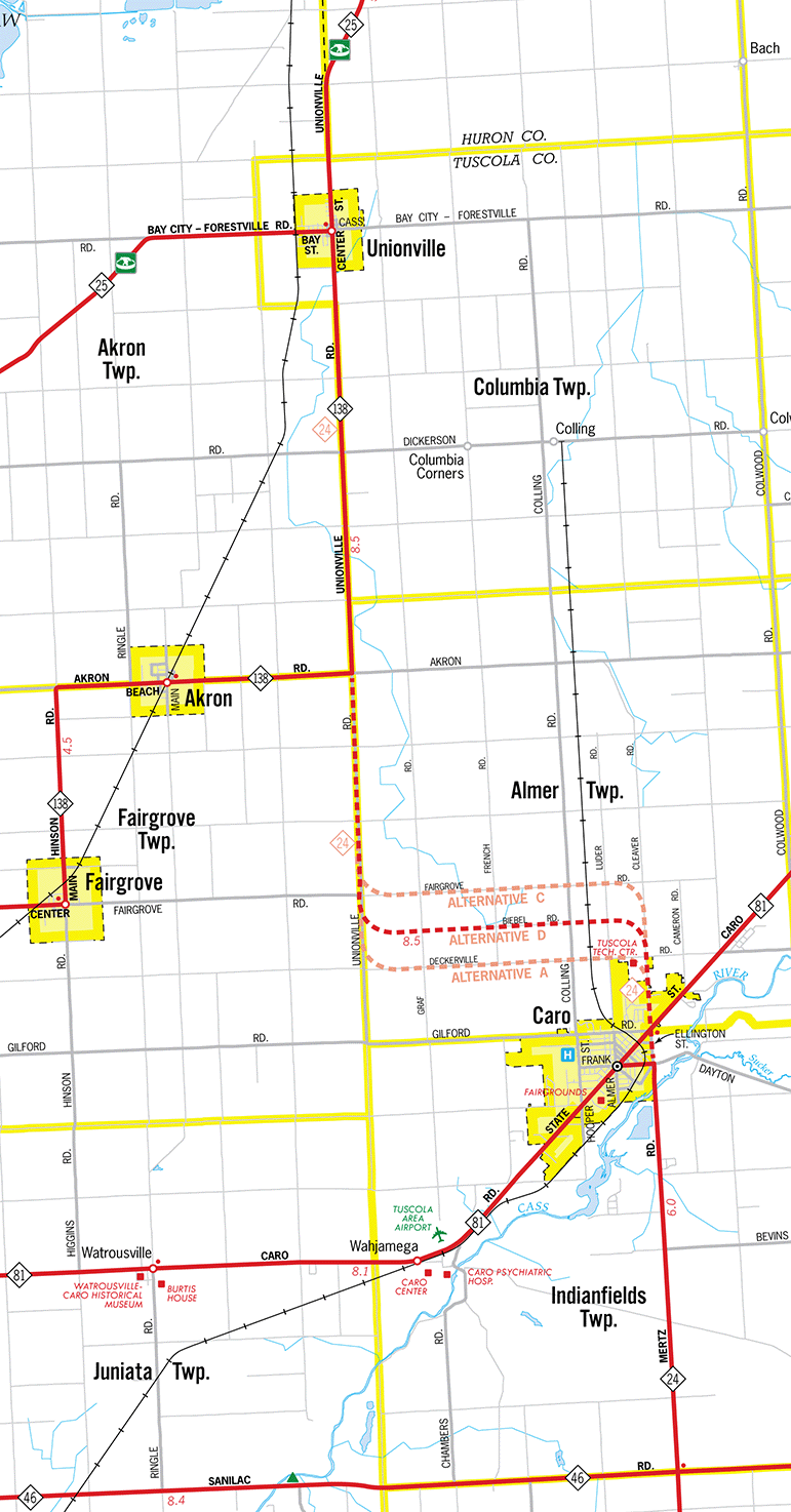
In May 1970, the Dept of State Highways announced construction on the portion of the M-24 extension from Caro to M-138 would begin in 1974 and cost $2.3 million. The M-138 improvements, now projected at $1.9 million, would be completed in a second phase. That October, the department published the "Location Study Report for M-24 Extension, Caro to M-25" which examined the need for the extension and the area’s characteristics, considering two possible corridors. The State Highway Commission approved the report in December 1970, proceeding with the Cleaver–Beibel–Unionville route as the preferred one. But by February 1961, the "Committee for a Compromise Route" formed at Owenville to champion a route closer to their community and proceeding to Caseville.
Progress and Approvals
Pressing on, the Dept of State Highways delivered the "Draft Corridor Environmental Impact Statement" for the extension to the Council on Environmental Quality on April 5, 1972 with two possible corridors, A and B, being specifically considered. Then on January 10, 1973, they issued the "Final Corridor Environmental Impact Statement" incorporating the comments received in response to the draft version. Corridor A was the recommended alignment and just 13 days later, it was approved by the Federal Highway Administration 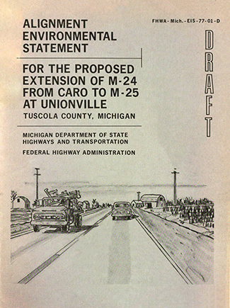 (FHWA). Two years passed before the renamed Dept of State Highways & Transportation formed a Location Team to "review past studies and apply an interdisciplinary approach to the development of illustrative alternatives within Corridor A." Another public meeting at Caro High School on March 4, 1976, solicited additional input and comments on the Corridor A alternatives. A year later, and the department released the "Alignment Environmental Statement" addressing the "impacts of the alternatives and alternate alignments considered for this project." At this point, contracts were planned to be let in 1980 with the new highway completed in 1981 or 1982.
Another public hearing at Caro High School on November 30, 1977, had 150 in attendance but only nine people commented, with only one in opposition of the Biebel Rd alignment (Alternative D on the map). Local officials preferred Alternative D as having the least negative impact on the community, but state officials warned it had the highest level of environmental disruption. Because of this, the Dept of State Highways & Transportation was reportedly examining routing the M-24 extension via Dutcher Rd instead, 2½ miles north of the preferred Biebel Rd alignment. However, on October 26, 1978, the State Highway Commission approved—yet again—the M-24 extension route between Caro and Unionville, though project costs had risen to $10 million by then.
A Decade Delay, then Construction Begins
A decade would pass, however, before any actual construction on the route started, likely due to highway construction funding issues. The first phase of the M-24 extension project kicked off in the summer of 1988 with the reconstruction of the ½ mile of existing M-138 in Unionville. The roadway was rebuilt and widened from two to four lanes, completed in July 1989. The second phase, also beginning in 1988, reconstructed and widened existing M-24/Mertz Rd from Gun Club Rd to Frank St in Caro, then northerly along Ellington St to M-81/State St and then 500 feet north on Cleaver Rd. (Mertz Rd, Ellington St and Cleaver Rd are the various names for the north-south roadway along the eastern edge of Caro.) This overall 1.1-mile, $1.88 million project, completed in August 1989, included reconditioning the M-24 Cass River bridge, including a new roadway surface, pedestrian walkway, new barrier walls and bridge pier repairs. Then on October 27, 1990, the 5.3-mile, $1.8 million third phase which reconstructed and modernized existing M-138/Unionville Rd from Unionville southerly to Akron Rd was completed and opened to traffic. This portion of M-138, which was to become part of the M-24 extension once the Caro-to-Akron Rd segment was built, was widened from an 18-foot-wide roadway to 24-feet wide with full shoulders and brought this portion up to All-Season standards.
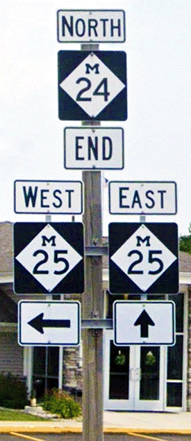
Earlier in 1990, the Village of Caro transferred jurisdiction of the rebuilt Ellington St between Frank St and M-81/State St to state control on April 30, establishing it as a state trunkline route. This was likely when the route of M-24 itself was rerouted northerly along Ellington St from Frank St to terminate at M-81/State St instead of turning 90° onto Frank St to end in downtown Caro as it had since 1942. Frank St between Ellington St and downtown Caro, though, is not transferred to municipal control and remains and unsigned trunkline route.
As of Spring 1991, the four phase—the 8.3-mile portion of the extension involving the only "new alignment " construction of the project—had been "fine-tuned" to shift the roadway route to avoid needing to relocate 1½ miles of county trains and some utility lines, saving upwards of $200,00 in construction costs. At that point, MDOT planned to begin construction on the final phase by the end of 1993.
A Third Major Setback
In February 1993, brothers Robert and Don Mantey of Fairgrove raised objections that project planners and engineers failed to consider wetland disturbance when the project was first planned in the 1960s. There were few, if any, wetlands protections in the early 1960s, but that changed in the late 1960s and 1970s. The Dept ![]() of Natural Resources (DNR) then intervened to begin a review of the fourth phase in March and denied MDOT’s request to fill 6.6 acres of wetland on the Beibel Rd alignment on June 7. A DNR water quality specialist noted, "After due consideration of the permit application, on-site investigations and other pertinent materials, the department finds that the proposed activity would have a significant adverse impact on the natural resources, public interest, and public trust held in the wetlands to be filled." The existence of what the DNR felt was a "feasible alternative" contributed to the ruling. MDOT appealed, noting an existing wetlands replacement provision in the project and any change in alignment would impact additional residences, farmland and three miles of county drains. They referred to the DNR ruling as "an interim setback."
of Natural Resources (DNR) then intervened to begin a review of the fourth phase in March and denied MDOT’s request to fill 6.6 acres of wetland on the Beibel Rd alignment on June 7. A DNR water quality specialist noted, "After due consideration of the permit application, on-site investigations and other pertinent materials, the department finds that the proposed activity would have a significant adverse impact on the natural resources, public interest, and public trust held in the wetlands to be filled." The existence of what the DNR felt was a "feasible alternative" contributed to the ruling. MDOT appealed, noting an existing wetlands replacement provision in the project and any change in alignment would impact additional residences, farmland and three miles of county drains. They referred to the DNR ruling as "an interim setback."
After a review, the DNR reversed their decision on November 4, 1993, and agreed to issue permits to fill the wetlands after community outcry and an agreement by MDOT to raise the amount of replacement wetlands from 8.6 acres to 13.2. After the many delays, the last 8.3-mile phase of the M-24 extension project was anticipated to cost $11 million as compared with the $3.2 million initially estimated in 1966 for the entire 15½ mile project. The path now seemed to be clear to complete the project.
The Fourth, Fifth and Sixth Snags
In early December 1994 as MDOT was completing final right-of-way acquisitions on the final phase, a legal "snag" again threatened to derail the project. This time, a stipulation in the plats for the Northwood Height subdivision off Cleaver Rd only allowed land in the plats to be used for "residential purposes." Legally, MDOT could not use land purchased in the subdivision for highway purposes. While the department worked to remedy this legal issue, another delay occurred, once again, due to budgetary issues. Planning and engineering would continue, though, in the hope that money would be found in time to get the construction schedule back on track. But less than two weeks later, MDOT made an about face and pledged to go ahead with letting contracts in the spring of 1995 with construction beginning that summer, even though project funding had yet to be specifically identified. An increase in federal transportation funding was anticipated during 1995 which would allow the project to go ahead as planned.
Another environmentally related issue cropped up just six weeks after the previous "snag" when compliance issues with the Clean Air Act of 1992 threatened the project. While the project itself did not violate clean air regulations, Tuscola and surrounding counties lacked up-to-date data on air quality which prevented the Environmental Protection Agency (EPA) from issuing the necessary approvals to continue. Certain environmental criteria needed to be met, but without the data to prove that it did, the project couldn’t proceed. MDOT worked with the EPA and FHWA, though, and eventually found sufficient data to satisfy the Clean Air Act requirements.
No More Hurdles: The Extension is Completed!
Finally, in September 1995, the contracts to complete the fourth phase of the project were issued and on October 23, a project "groundbreaking" was held in front of what was then Great Lakes Junior College (now the Tuscola Technology Center) on Cleaver Rd in Caro. Even after construction began, some area residents turned up at MDOT project information meetings to really see if this highway would truly be completed at long last. Joel Ingle, an MDOT design engineer, stated, "Many of the people who attended the meetings just wanted to see for themselves what was going on. Some just couldn't believe the project is finally going to begin."
After a year of construction, the "new alignment" portion of the route from Graf Rd easterly along the Biebel Rd corridor then curving southerly on Cleaver Rd to M-81 in Caro was finished by December 1996 and was used by a handful of vehicles even though it wasn’t yet officially open to traffic. Work proceeded on the segment from Graf Rd westerly then curving northerly onto Unionville Rd to M-138 at Akron Rd in 1997 and on October 5, the long-awaited M-24 extension from Caro to Unionville was finally complete and open to traffic, after 35 years! M-138 from Akron Rd to M-25 at Unionville was redesignated as the northernmost part of the extension. Through numerous delays and "snags," the Thumb now, finally, had its third north-south All-Season roadway.
Additional Information