

| Back to Previous Route: M-129 |
 |
On to Next Route: US-131 |
| M-130 is a former state trunkline route existing from c.1928 until October 1, 1959. | |
| Western Terminus*: | Jct US-23 & M-50 at cnr of S Custer Rd, Lewis Ave & Ida Maybee Rd, 2½ miles north of Ida |
| Eastern Terminus*: | Jct US-25 & M-56 in downtown Monroe at cnr of N Monroe St & Elm Ave |
| Final Length*: | 10.230 miles 12.281 miles (inclduing mainline M-130 + M-130 EXTENSION) |
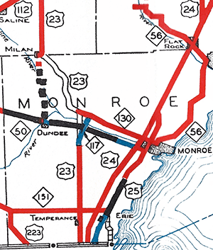
| Maps: | Route Map of Former M-130 |
| Notes: | * The termini and final length for M-130 reflect the beginning and ending of the route and its length as of the time of its decommissioning in late 1959. |
| Former M-130 is rather enigmatic as far as historic highway routes are concerned. Firstly, for its entire existence, it closely paralleled an existing trunkline—M-50—running westerly from Monroe toward Dundee on the opposite side of the River Raisin. At its farthest point, the east-west portion of M-130 was never more than 1½ miles from M-50 and was 850 feet north of it at its closest. M-130 was actually a former routing of M-50 which had been relocated from the north side of the river to the south side in the late 1920s. Second, the precise date of the commissioning of M-130 as a route designation is not quite clear from historical documentation, State Highway Dept maps and news reports, which, for state highways from that timeframe, is a bit odd. Third, the exact date of M-130's decommissioning is also unlear: The entire route, including the M-130 EXTENSION (see below), last appears on the October 1, 1955 Michigan Official Highway Map—implying it was decommissioned between then and the issuance of the April 1, 1956 edition of the map—while State Highway Dept Trunkline Determination Maps clearly show that M-130 was cancelled as a state trunkline highway route in its entirety on October 1, 1959, four entire years later! While it is possible the M-130 route markers were removed from the route in late 1955 (or early 1956) in preparation for that route's eventual transfer back to local control, an August 1957 news report mentions the State Highway Dept taking bids to replace "the existing sturcture carrying M-130 over the Raisin river [sic] about a half mile southwest of the village [sic] of Grape." So, although M-130 route markers may have taken down in the 1955–56 timeframe, this listing will assume October 1, 1959 to be the official date of the route's decommissioning. | |
| The route of M-130 remained relatively static over its entire three-decade existence. From an eastern terminus at jct US-25/Monroe Ave & M-56/Elm Ave in Monroe, M-130 proceeded westerly via Elm Ave to the west city limit at US-24/Telegraph Rd, then contunued westerly on the north side of the River Raisin along N Custer Rd to the hamlet of Grape where it met M-130 EXTENSION (M-130 EXT). There, mainline M-130 turned southwesterly to cross the river via Ida Maybee Rd, through a jog at Dixon Rd, then southwesterly to its western termuinus at jct US-23/Lewis Ave & M-50/S Custer Rd. | |
 From 1925 until 1949 when US-23 (originally M-65) was proposed to continue due northerly from the Ida area along a new alignment to a new River Raisin crossing then bend northwesterly to head toward Milan, the plan was for mainline M-130 to continue westerly from the Grape area via N Custer Rd (along M-130 EXT) to a new western terminus at the newly-constructed US-23 route near the DT&I Railroad overpass. The State Highway Dept had given the portion of existing Lewis Ave from the curve north of Ida to M-50/S Custer Rd as well as the segment of M-130 along Ida Maybee Rd to M-130/N Custer Rd near Grape a new route designation: M-117. This M-117 designation was apparently to have been the designation once the US-23 designation was relocated to its new alignment and M-130 continued westerly along N Custer Rd. However, since this new route for US-23 was never constructed, this first iteraiton of M-117 was never signed as such and the US-23 and M-130 route markers remained in place along their respective routes. In the snippet of the 1936 State Highway Dept map included here, the open-band roadway symbol (two thin black lines filled with white in between) indicates routes which were unimproved or had not yet been constructed. The dashed line between Dundee and Milan shows the "temporary" route for US-23 which later became its permanent route. By 1939, any M-117 markers had been removed from internal State Highway Dept maps in central Monroe Co. From 1925 until 1949 when US-23 (originally M-65) was proposed to continue due northerly from the Ida area along a new alignment to a new River Raisin crossing then bend northwesterly to head toward Milan, the plan was for mainline M-130 to continue westerly from the Grape area via N Custer Rd (along M-130 EXT) to a new western terminus at the newly-constructed US-23 route near the DT&I Railroad overpass. The State Highway Dept had given the portion of existing Lewis Ave from the curve north of Ida to M-50/S Custer Rd as well as the segment of M-130 along Ida Maybee Rd to M-130/N Custer Rd near Grape a new route designation: M-117. This M-117 designation was apparently to have been the designation once the US-23 designation was relocated to its new alignment and M-130 continued westerly along N Custer Rd. However, since this new route for US-23 was never constructed, this first iteraiton of M-117 was never signed as such and the US-23 and M-130 route markers remained in place along their respective routes. In the snippet of the 1936 State Highway Dept map included here, the open-band roadway symbol (two thin black lines filled with white in between) indicates routes which were unimproved or had not yet been constructed. The dashed line between Dundee and Milan shows the "temporary" route for US-23 which later became its permanent route. By 1939, any M-117 markers had been removed from internal State Highway Dept maps in central Monroe Co. |
|
| M-130 EXTENSION. Essentially from the time of M-130's debut in c.1928, a 1.9-mile long spur route along N Custer Rd from mainline M-130 at Ida Maybee Rd west-northwesterly to the DT&I (later Grand Trunk Western, now Candian National) Railroad overpass in western Raisinville Twp. This spur route—which was likely signed with regular "M-130" route marker assemblies without any "EXTENSION" signage—was intended to connect with the proposed northerly extension of US-23/Lewis Ave from the Ida area which would have begun to curve northwesterly as it crossed the River Raisin before continuing north-northwesterly toward Washtenaw Co. This first segment of the proposed US-23 was established as a trunkline route in 1925 as far as the western boundary of Raisinville Twp, then from that point northwesterly to Milan in 1935. This particular proposed route of US-23 was cancelled as a trunkline route in late 1949, although the M-130 EXT remained a spur state trunkline route into the 1950s, before being officially cancelled in late 1959. The history of the "extension" is included in the "History" section below. The "extension" portion of M-130 first appeared on official state highway maps in 1939 and remained on official maps until the entirety of M-130 was removed from the maps in 1955–56. | |
| History: | 1915–1919 – The initial route of T.L. 50 (M-50) between Dundee and Monroe in 1915 follows South Custer Rd from Dundee easterly to Raisinville Rd where it jogs northerly across the River Raisin via a bridge or ford to North Custer Rd, then runs easterly via North Custer Rd to Monroe. Then in 1919, likely due to a failure of the River Raisin crossing at Raisinville Rd, Ida Maybee Rd from S Custer Rd northerly across the river to North Custer Rd near Grape, and North Custer Rd from Ida Maybee Rd easterly to Raisinville Rd is officially established as a state trunkline route and the M-50 route is moved to that alignment, with the former route on the south side of the river cancelled as a trunkline route. |
| 1928 – By late 1928, the route of M-50 between US-23/Lewis Ave and the City of Monroe is transferred back to the south side of the River Raisin, running along South Custer Rd, although that portion of highway would not be officially established as a state trunkline highway route for over a decade! Thus, the segment of M-50 along South Custer Rd between US-23/Lewis Ave and Monroe becomes a "marked-and-maintained" trunkline route, while the former route of M-50 along Ida Maybee Rd and North Custer Rd is likely designated and signed as M-130 at this point. | |
| 1928 (May 24) – The 1.9-mile long segment of North Custer Rd from Ida Maybee Rd near the hamlet of Grape west-northwesterly to the DT&I Railroad overpass is officially established as a state trunkline highway route. It is intended to link existing M-130 with the proposed realignment of US-23 between Ida and Milan. Until the realigned US-23 route is constructed, this 1.9-mile trunkline, officially designated as M-130 EXTENSION and likely unsigned for the time being, will simply terminate at the DT&I Railroad overpass. | |
| 1932 (Oct 29) |
|
| 1936 – As noted in the "Notes" section above, starting in 1936, internal State Highway Dept maps begin indicating that the portion of M-130 along Ida Maybee Rd between the jct of US-23 & M-50 and North Custer Rd is to be designated M-117 once the proposed US-23 realignment is completed and mainline M-130 is reduced to only running along North Custer Rd. Until that time, though, M-117 is not posted in the field and all M-130 route markers remain. | |
| 1938 (Late) – In the last half of 1938, the spur route of M-130 EXTENSION begins showing up on official state highway maps and is likely signed as a third leg of M-130 (without any "EXTENSION" signage) at this time. All State Highway Department county road maps of Monroe Co after this point show M-130 route markers along both Ida Maybee Rd between M-50/S Custer Rd and North Custer Rd as well as along the M-130 EXTENSION segment of North Custer Rd, supporting the idea that M-130 is, indeed, signed as a three-legged route. Also around this same time, any references on internal State Highway Dept maps to a proposed M-117 designation along the Ida Maybee Rd segment of M-130 are removed. | |
| 1955 (Late)/1956 (Early) – The last official state highway map depicting M-130 is the October 1, 1955 edition and it is removed from the April 1, 1956 issue, implying the State Highway Dept has removed the M-130 route markers from the highway at this point in preparation for decommissioning the route and turning it back to local control. However, that turnback will not occur until the very end of the decade and references to M-130 in the media after this point still occur. | |
| 1957 (Aug 14)–1958 (July 31) – The State Highway Dept accepts bids for the "construction of a new bridge on the site of the existing structure carrying M-130 over the Raisin river [sic] about a half-mile southwest of the village [sic] of Grape" on August 14, 1957, even though M-130 itself had been removed from official state highway maps a year or two prior. Completion of the new structure is scheduled for July 31, 1958. | |
| 1959 (Oct 1) – The entirety of M-130—all three legs along North Custer Rd/Elm St from downtown Monroe to the DT&I Railroad overpass and the Ida Maybee Rd segment—is cancelled as a state trunkline highway route and turned back to local control. Interestingly, though, the 0.25-mile long set of access ramps called Custer Dr on the western limits of Monroe providing access between North Custer Rd and US-24/Telegraph Rd (which is grade-separated from North Custer Rd as it runs close to the shore of the River Raisin at this location) is not cancelled and is temporarily retained as a state trunkline highway. | |
| 1960 (Apr 6) – Just over six months after the entirety of M-130 is cancelled as a state trunkline route, the 0.25-mile long access ramps known as Custer Dr on the western limit of Monroe that provide access to and from US-24/Telegraph Rd are also cancelled as a state trunkline highway route and transferred to local control, thus sending the last vestiages of M-130 to the history books after just over 30 years. | |
| Controlled Access: | No portion of M-130 was freeway or expressway, existing largely before modern-day control of access principles are practiced. |
| Photographs: |
|
| Weblinks: |
|
| Back to M-129 | Route Listings Home | On to US-131 |