

M-66 Missaukee/Kalkaska Controversy
Three Versions of a Modernization Effort
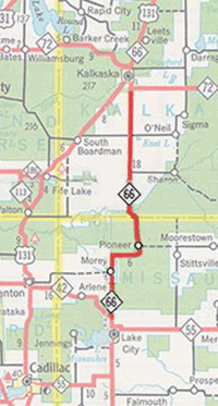 In the 1960s, the Michigan State Highway Department concluded the route of M-66 between Lake City in Missaukee Co and Kalkaska in Kalkaska Co was in need of modernization. From early on, many state trunkline highway routes had been simply upgraded and widened from existing local roads over the decades and were narrow, winding, had poor sight lines and bad horizontal alignments. During the middle of the 20th Century, many of these routes were chosen to be what the State Highway Department termed "modernized" through reconstruction, rerouting and horizontal alignment improvements. Two segments, from M-42 to the hamlet of Morey in Missaukee Co and from Smithville to Kalkaska in Kalkaska Co, were largely upgraded on their existing alignment or immediately adjacent to the existing highway on a widened right-of-way, which was a popular method used to "modernize" highways in that time.
First, M-66 in Kalkaska Co from north of Smithville to M-72 south of Kalkaska was modernized in the early 1960s. Meanwhile, in 1968, Department engineers finalized an alignment for the remainder of the project. Two years later, a public hearing was held on the 11.6-mile portion of the project from M-42 to north of Smithville in mid-April 1970, with no major objections to the chosen route noted. The modernized highway would shift west off existing M-66 north of M-42 and run immediately adjacent to the existing highway to a mile north of Morey. There, the relocated route would bend northeasterly crossing back over existing M-66 (Phelps Rd) approximately ¾ mile east of Morey Rd then slowly curve northerly to run along the section line approximtely ¾ mile west of the existing M-66. The new alignment would then merge into the existing highway where it made a sharp curve south of the Manistee River bridge at Smithville. (See map.)
The first segment to be completed moved M-66 onto its modernized alignment from M-42 to north of Morey, although there was an issue where the construction spoiled Hopkins Creek, a pristine coldwater tributary of the Manistee River. Several thousand dollars were expended by the Department, the County and the Department of Natural Resources in an attempt to correct the problems. However, this raised the ire and increased scrutiny of environmentalists. When it was learned the new highway was proposed to traverse the Filer Creek swamp, potentially causing extreme environmental impact and degradation of water quality and wildlife habitat in the area, the West Michigan Environmental Action Council (WMEAC), Trout Unlimited, and other concerned citizens advocated for a major change in the realignment route or an outright cancellation of the project.
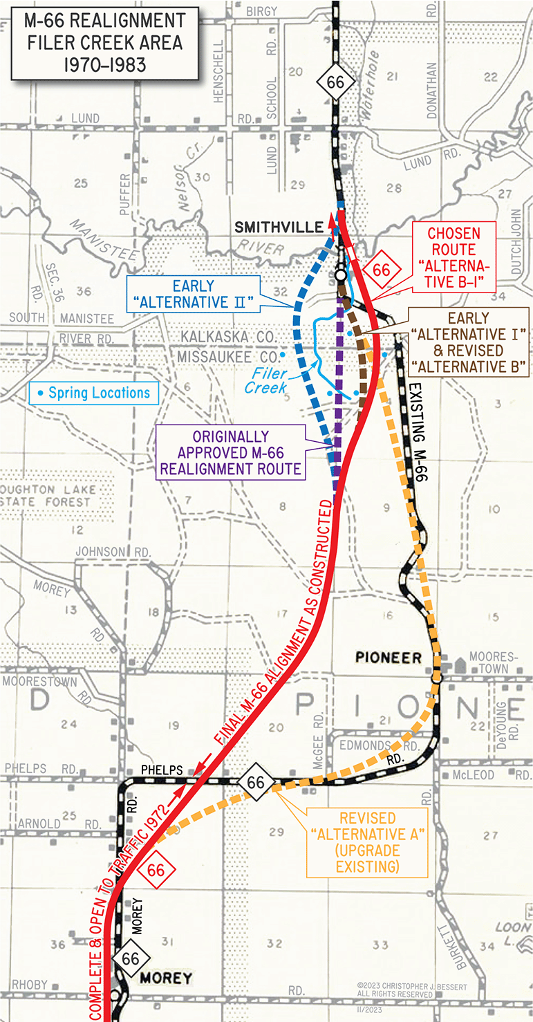 Unfortunately, the State Highway Department had already purchased all of the right-of-way needed for the originally-proposed alignment for the relocation of M-66 in 1970 and 1971 and was also unwilling to recreate all the studies and engineering it already completed for a new route. Another complicating factor was the originally-proposed alignment had been approved by the Department of Natural Resources, even in light of recently-passed legislation enacted to help preserve and protect Michigan's inland lakes and streams. In early 1975, new DNR Director Howard A. Tanner stated he felt he was unable to force any changes as it would be "very difficult" to reject the route and still have the DNR appear to be "consistent and reasonable." He felt his hands were tied on the matter, with the only alternative making his Department look bad. However, after threatened legal action by the environmental groups, the State Highway Department evaluated two alternate routes (labeled "Alternative I" and "Alternative II" on the map) and settled on bending the relocation slightly to the east to avoid the headwaters of Filer Creek, although the new routing would still cross the creek closer to its mouth in the same area the existing route already did. The main benefit cited in choosing this alignment ("Alternative I") is it avoided many of the environmental issues in the Filer Creek area but still allowed the Department to utilize the existing—but aging—M-66 bridge over the Manistee River, saving on construction and right-of-way costs. However, this was still not acceptable to those who feared the irreversable environmental damage it would cause. Regardless, the now-renamed Department of State Highways & Transportation (MDSH&T) began purchasing additional right-of-way along the easterly "Alternative I" route.
As late as early 1975, an MDSH&T environmental specialist flat out stated the Department would not even consider the possibility of a new highway alignment for several reasons, including having to "maintain basic design standards for a rural, two-lane highway," the "time and costs required to develop a new 'approved' alignment," the "escalation in construction costs due to the delay," and the "loss of time and money already expended in abandoning the design plans for the approved alignment." The fact that purchasing had already begun on a second right-of-way for the new highway was also a huge factor in the Department's unwillingness to condsider other options.
However, after further threat of legal action from the environmental groups, in mid-1975 the Department halted buying right-of-way and relented to the pressure by commencing another study to find an acceptable route for M-66 through the Filer Creek area. A new study resulted in lettered alternatives this time, with "Alternative A" being a new highway built largely in the existing highway corridor before merging into the original "Alternative I" alignment which crossed Filer Creek near the existing crossing and tying into the existing route before crossing the Manistee River on the existing bridge. "Alternative B" duplicated the "Alternative I" from the 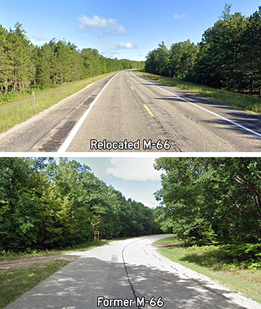 earlier study. This time, though, an additional "Alternative B-1" was also proposed which swung even farther to the east, avoiding even more of the wetland areas around Filer Creek as well as no longer impacting the creek itself. This alternative did require a new bridge spanning the Manistee upstream of the existing structure, though, but by this time the Department was realizing the existing structure was aging and likely in need of replacement anyway. In the fall of 1976, "Alternative B-1" was officially selected by Department of State Highways & Transportation staff. After further review and comment by other local, state and federal agencies and other interested groups, final approval was given to go ahead with the last phase of the relocation. (See map.)
So, now with a third alignment for M-66 through the area selected, the Department completed the necessary engineering and purchased right-of-way on this alignment beginning in 1979 and into 1981. Construction commenced and the new highway was completed and opened to traffic by 1982, including a new Manistee River bridge. Most of the former route of M-66 actually remained an unsigned state trunkline for a decade-and-a-half, only being transferred back to county control in 1994 in Missaukee Co and 1996 in Kalkaska Co. Along with the new Manistee River span, the original bridge dating from the early 1930s was removed as was the smaller bridge over Filer Creek to the south. An access roadway was constructed linking new M-66 with the now-isolated segment of Old M-66 south of the Manistee River, which was then renamed Jacks Landing Rd. The newly dead-ended segment of former M-66 north of the river was named Blue Bird Dr. In all, the Filer Creek controversy delayed completion of the project by an etire decade.