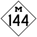
M-144 is a former state trunkline route existing from: 1) November 25, 1929 until December 30, 1930,
2) August 17, 1931 until July 13, 1939, and
3) November 12, 1940 to November 1, 1973
|
| Southern Terminus*: |
 Jct M-18 & M-76 in downtown Roscommon at cnr Lake St & Fifth St Jct M-18 & M-76 in downtown Roscommon at cnr Lake St & Fifth St |
| Northern Terminus*: |
M-72/South Down River Rd at cnr McMasters Bridge Rd, 7 miles west of Luzerne |
| Final Length*: |
15.033 miles |
| Maps: |
Route Map of Former M-144 |
| Notes: |
* The termini and final length for the most recent iteration of M-144 reflect the beginning and ending of the route and its length as of the time of its decommissioning in November 1973. |
| |
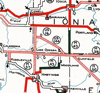 There have been three iterations of M-144 during the period 1929–1973, although the first occurrence of the route only existed on a proposed trunkline which was never built and was cancelled before it was ever signed. In late-1929, a new trunkline route was established in southwest Ionia Co running roughly parallel to and south of the Pere Marquette Railway (later C&O, Chessie System, now CSXT) line between M-50 on the west side of Lake Odessa then northwesterly to west of Clarksville at a proposed relocation of M-66 running from Hastings due northerly to US-16/Grand River Ave southwest of Saranac. Plans show the State Highway Dept was planning to extend M-39 almost due westerly along the Ionia/Barry and Kent/Barry Co line to M-37 south of Caledonia as well as either extend M-66 southerly into Hastings. To replace the existing segment of M-50 west of Lake Odessa, the Department created a replacement route on the angling alignment. However, none of these plans—M-39 west Caledonia, M-66 due south into Hastings, or the proposed M-144 route—were ever constructed. Just over a year after its initial establishment, the M-144 designation along the proposed Lake Odessa–Clarksville angling route was reassigned as part of a new route for M-50. (The "US" 144 symbol in the map snippet above is in error—it was obviously going to be M-144 and was shown as such on Trunkline Determination Maps from that time.) There have been three iterations of M-144 during the period 1929–1973, although the first occurrence of the route only existed on a proposed trunkline which was never built and was cancelled before it was ever signed. In late-1929, a new trunkline route was established in southwest Ionia Co running roughly parallel to and south of the Pere Marquette Railway (later C&O, Chessie System, now CSXT) line between M-50 on the west side of Lake Odessa then northwesterly to west of Clarksville at a proposed relocation of M-66 running from Hastings due northerly to US-16/Grand River Ave southwest of Saranac. Plans show the State Highway Dept was planning to extend M-39 almost due westerly along the Ionia/Barry and Kent/Barry Co line to M-37 south of Caledonia as well as either extend M-66 southerly into Hastings. To replace the existing segment of M-50 west of Lake Odessa, the Department created a replacement route on the angling alignment. However, none of these plans—M-39 west Caledonia, M-66 due south into Hastings, or the proposed M-144 route—were ever constructed. Just over a year after its initial establishment, the M-144 designation along the proposed Lake Odessa–Clarksville angling route was reassigned as part of a new route for M-50. (The "US" 144 symbol in the map snippet above is in error—it was obviously going to be M-144 and was shown as such on Trunkline Determination Maps from that time.) |
| |
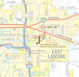 The second iteration of M-144 served as a short spur trunkline route from M-39 (later M-43, now M-143) southerly along Harrison Rd to the Michigan State Police Headquaters on the campus of Michigan State College (now MSU). While the Michigan State Troops, also known as the Michigan Cavalry or Michigan Constabulary, had constructed a headquarters complex on land owned by MSC in 1917, a new permanent, modern administration building for the renamed Michigan State Police was completed in 1932. The M-144 spur route was created in an era when many, many short trunkline segments were established leading to state facilities, state parks, and small towns not located directly on trunkline routes. By the late-1930s, sentiment changed and many of these short spurs were cancelled and turned back to local control, including the ½ mile route of M-144. (The Michigan State Police remained headquartered on Harrison Rd in East Lansing until they moved to new base of operations in downtown Lansing in 2010. The former MSP facility was demolished in May 2012.) The second iteration of M-144 served as a short spur trunkline route from M-39 (later M-43, now M-143) southerly along Harrison Rd to the Michigan State Police Headquaters on the campus of Michigan State College (now MSU). While the Michigan State Troops, also known as the Michigan Cavalry or Michigan Constabulary, had constructed a headquarters complex on land owned by MSC in 1917, a new permanent, modern administration building for the renamed Michigan State Police was completed in 1932. The M-144 spur route was created in an era when many, many short trunkline segments were established leading to state facilities, state parks, and small towns not located directly on trunkline routes. By the late-1930s, sentiment changed and many of these short spurs were cancelled and turned back to local control, including the ½ mile route of M-144. (The Michigan State Police remained headquartered on Harrison Rd in East Lansing until they moved to new base of operations in downtown Lansing in 2010. The former MSP facility was demolished in May 2012.) |
| |
As an aside, the M-144 route designation is completely unrelated to the M-143 designation now running along Michigan Ave in East Lansing. During the second iteration of M-144, Michigan Ave (the northern terminus of M-144) was designated as part of M-39 until 1938 when it was replaced by the M-43 designation, which remained until M-144 was decommissioned in 1939. Michigan Ave was not designated as M-143 until 33 years later in 1962. |
| |
The third and most recent iteration of M-144 was created in 1940 as a replacement route designation for what had formerly been part of M-72 from M-76 on the Roscommon/Crawford Co line east of Roscommon northeasterly to M-72 at Luzerne in western Oscoda Co. M-72 was rerouted to run westerly from Luzerne into Grayling and then take over the route of M-76 westerly from there toward Kalkaska and Empire. After several realignments, a shortening and an elongation over the ensuing three-plus decades, the third iteration of M-144 came to an end in 1973 when it was replaced by a northerly extension of M-18 due to the completion of the I-75 freeway in the region. |
| |
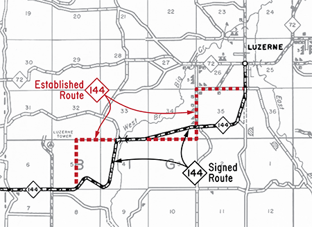 Interestingly, the officially established route of M-144 in Oscoda Co—which was originally established as part of Trunk Like 33 in 1916 and signed as M-33 in 1920, then redesignated as part of M-72 in 1927, then incorporated into the route of M-144 in 1940—had always differed from the actual signed route in the field, for reasons unknown at present. Whether the State Highway Dept considered the signed-but-not-established portions of the route as a "marked-and-maintained" route or just that the signed and established route didn't quite "match" is unclear. However, when M-144 was modernized and realigned in 1961 and the former route of M-144 in Oscoda Co was cancelled as a state trunkline route and turned back to county control, the 7.5-mile long officially established route was the one that was cancelled. The signed route, however, was approximately 6.95-miles in length. Interestingly, the officially established route of M-144 in Oscoda Co—which was originally established as part of Trunk Like 33 in 1916 and signed as M-33 in 1920, then redesignated as part of M-72 in 1927, then incorporated into the route of M-144 in 1940—had always differed from the actual signed route in the field, for reasons unknown at present. Whether the State Highway Dept considered the signed-but-not-established portions of the route as a "marked-and-maintained" route or just that the signed and established route didn't quite "match" is unclear. However, when M-144 was modernized and realigned in 1961 and the former route of M-144 in Oscoda Co was cancelled as a state trunkline route and turned back to county control, the 7.5-mile long officially established route was the one that was cancelled. The signed route, however, was approximately 6.95-miles in length. |
| |
In "State Trunkline Needs, 1960–1980," a set of maps prepared by the State Highway Dept's Office of Planning, Programming Division in 1960 showing possible additions, upgrades and improvements to the state trunkline system over the ensuing twenty years, MSHD staff recommended two realignments for M-144. One realignment running from Flooter Rd to Hunters Lake Rd removing three turns from the route, with a second realignment at Eldorado continuing northerly along an upgraded McMasters Bridge Rd to a new terminus at M-72, removing the route from Oscoda Co in the process. Both of these proposals were ultimately implemented within the next 12–18 months of the publication of the maps, meaning the changes were already in the works at the time. |
| History: |
1929 (Nov 25, Dec 2) – A new state trunkline route on a new alignment is established in southwest Ionia Co on November 25 from M-50/Tupper Lake Rd east of Tasker Rd at Lake Odessa, then northwesterly paralleing and just south of the Pere Marquette Railway line to Clarksville Rd, less than one mile west of downtown Clarksville, and given the proposed designation of M-144. A week later on December 2, an additional 1.5-mile of trunkline extension is established from Clarksville Rd northwesterly to the cnr of Bell & Drew Rds, then westerly for a mile along Drew Rd to Hastings Rd, which is the proposed route for a new routing for M-66 heading due northerly from Hastings to US-16/Grand River Ave southeast of Lowell. The new route is not yet constructed and the designation only exists "on paper" for the time being. |
| |
1930 (Dec 30–31) – Over the course of two days, the route of M-50 between Lake Odessa in southern Ionia Co and US-16 near Alto (south of Lowell) in Kent Co is cancelled as a state trunkline route. First, on December 30, the the 9.1-mile Ionia Co portion of M-50 from the Kent Co line easterly along Thompson Rd, Nash Hwy and Tupper Lake Rd to just east of Tasker Rd is cancelled. Then on December 31, the 9.0-mile Kent Co portion of M-50 is cancelled beginning at US-16/Cascade Rd near Alto continuing southerly along Alden Nash Ave, then easterly via 92nd St to the Ionia Co line. The M-50 designation is likely moved to the new angling trunkline from Lake Odessa northwesterly past Clarksville which was established just over a year prior, replacing its initial designation of M-144. However, as the new anglihg route is not yet built, exisitng M-50 between US-16 and Lake Odessa remains signed along its existing route as a "marked-and-maintained" trunkline route. Thus ends the first iteration of M-144, albeit an unsigned iteration. |
| |
1931 (Aug 17) – The 0.5-mile section of Harrison Rd in East Lansing from M-39/Michigan Ave (present-day M-143) southerly across the Red Cedar River to the site of the new Michigan State Police Headquarters complex currently under construction is established as a state trunkline route and given the designation M-144, signaling the debut of the second iteration of that route designation. |
| |
1937 (May 15) – Interestingly, while M-144 in East Lansing had been established in August 1931, the State Highway Dept does not depict the route on its official highway maps issued to the public until early 1937. It is unclear why this is the case, whether M-144 is not signed in the field for its first six years or there are other reasons for its omission. However, the route does appear on all the State Highway Dept's official biennial report maps since its designation, although these maps aren't widely available to the general public. |
| |
1939 (July 13) – At a time when many short spur state trunklines and other short routes which are deemed to not rise to the level of state highway status are cancelled and removed from the system, the ½-mile long M-144 at East Lansing suffers the same fate and is, itself, cancelled and turned back to local control and the second iteration of that route comes to an end. |
| |
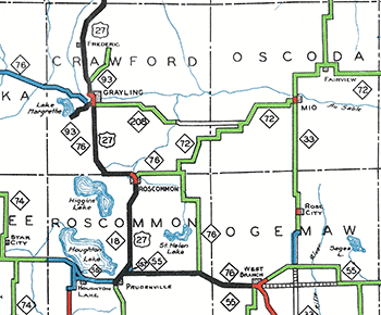 1940 (Nov 12) – The route of M-72 is drastically altered from Luzerne in Oscoda Co westerly. Previously, M-72 turned southwesterly in a stair-step fashion at the hamlet of Luzerne in western Oscoda Co and terminated at M-76 (modern-day Co Rd 602) on the Crawford/Roscommon Co line approximately seven miles east of downtown Roscommon. Also, from 1935–39, a trunkline route designated M-208 existed from Grayling easterly to M-72 at Luzerne, although only the western 13.3 miles of the route were signed and depicted on official state maps issued to the public (see map at right). The remaining approximately nine miles of the route from the Smith Bridge spanning the South Branch (of the Au Sable) River easterly to M-72 at Luzerne is unconstructed and the roadway roughly following the route is mostly impassible. While M-208 was cancelled as a state trunkline route in mid-1939, sixteen months later, it is re-established as a new alignment for M-72 which now runs westerly to Graying and takes over the route of M-76 from there westerly toward Kalkaska. The former route of M-72 between Luzerne and M-76 east of Roscommon is retained as a trunkline route and given the M-144 designation, marking the beginning of that route's third iteration. 1940 (Nov 12) – The route of M-72 is drastically altered from Luzerne in Oscoda Co westerly. Previously, M-72 turned southwesterly in a stair-step fashion at the hamlet of Luzerne in western Oscoda Co and terminated at M-76 (modern-day Co Rd 602) on the Crawford/Roscommon Co line approximately seven miles east of downtown Roscommon. Also, from 1935–39, a trunkline route designated M-208 existed from Grayling easterly to M-72 at Luzerne, although only the western 13.3 miles of the route were signed and depicted on official state maps issued to the public (see map at right). The remaining approximately nine miles of the route from the Smith Bridge spanning the South Branch (of the Au Sable) River easterly to M-72 at Luzerne is unconstructed and the roadway roughly following the route is mostly impassible. While M-208 was cancelled as a state trunkline route in mid-1939, sixteen months later, it is re-established as a new alignment for M-72 which now runs westerly to Graying and takes over the route of M-76 from there westerly toward Kalkaska. The former route of M-72 between Luzerne and M-76 east of Roscommon is retained as a trunkline route and given the M-144 designation, marking the beginning of that route's third iteration. |
| |
1949 (Late) – While not officially established as a state trunkline highway route, the relocation of M-76 on a new, 12.57-long direct alignment between Saint Helen and Roscommon in Roscommon Co, paralleling the Michigan Central (New York Central) Railroad line is completed as a gravel-surfaced highway and opened to traffic by the end of the year. The former route of M-76 from Saint Helen northerly via St Helen Rd, westerly along Au Sable Rd, northerly on Keno Rd, and westerly via Silsby Rd to M-144/Forester Rd is temporarily retained as an unsigned state trunkline for the time being. The former M-76 from that point westerly into Roscommon becomes a southwesterly extension of M-144, which lengthens the route by 6.9 miles bringing the total length to approximately 22 miles, it's greatest extent. |
| |
1961 (Sept 30) – A realignment and modernization project on M-144 in southeastern Crawford Co is completed and results in the establishment of two new segments of roadway. First, a 3.1-mile segment of new highway alignment from Flooter Rd (approximately 6½ miles northeast of Roscommon) northeasterly to Hunters Lake Rd shortens the route of M-144 by 1.2 miles. Second, a 2.4-mile segment of upgraded and partially realigned McMasters Bridge Rd from modern-day Old 144 at Eldorado northerly to a new northern terminus for M-144 at M-72/South Down River Rd shortens the length of M-144 by an additional 6.4 miles. The two bypassed portions of the former route of M-144—the 4.3 miles of Co Rd 602, Forester Rd and Hunters Lake Rd as well as the 8.8 miles of modern-day Old 144 from M-144 at Eldorado easterly and northeasterly into Oscoda Co to M-72/Park Rd at Luzerne—are cancelled and turned back to county control. The total 8.7-mile reconstruction project, completed for $460,000, brings the length of M-144 down to 15.1 miles and also results in M-144 now being paved in its entirety. |
| |
1973 (Nov 1) – With the completion and opening of I-75 between Roscommon and West Branch, the M-18 designation is rerouted beginning in downtown Roscommon to run northeastearly supplanting the entire route of M-144 to M-72 in southeastern Crawford County. As such, the third iteration of M-144 comes to a close and, as of the present-day, the M-144 designation has not been reused. |
| Controlled Access: |
No portion of Former M-144 was freeway or expressway. |
| Photographs: |
|
| Weblinks: |
|