
|
Business Connections 2 through 31 | |||||||||||||||||||||||||||
 Ironwood |
Western Terminus: | Wisconsin state line between Ironwood, Mich. and Hurley, Wisc. (where Silver St crosses the Montreal River) | ||||||||||||||||||||||||||
| Eastern Terminus: | US-2/Cloverland Dr at cnr of Douglas Blvd in Ironwood, just north of downtown | |||||||||||||||||||||||||||
| Length: | 1.270 miles | |||||||||||||||||||||||||||
| Map: | Route Map of BUS US-2 (Ironwood) | |||||||||||||||||||||||||||
| Notes: | ||||||||||||||||||||||||||||
| This highway was the only "bi-state Business Connection" in Michigan, and only one of a handful in the entire nation. Ironwood's BUS US-2 is also the second-shortest Business Connection in Michigan, only ½-mile mile longer than the shortest, BUS M-32 in Hillman. | ||||||||||||||||||||||||||||
| History: | 1933 (mid-Dec) |
|||||||||||||||||||||||||||
| 1939 (Mid) |
||||||||||||||||||||||||||||
| 1942 (Aug 10–15, 17) – The route of M-54 in Ironwood, which begins at US-2/Cloverland Dr & Douglas Blvd and continues southerly 7½ blocks to Frederick St, southwesterly one block via Frederick to Suffolk St, southeasterly 2 blocks along Suffolk to Aurora St, then southwesterly 4 blocks to a point approximately 125 feet beyond Albany St where it terminates, is redesignated in its entirety as BUS US-2, with new route markers replacing the existing M-54 signs August 10–15. Additionally, the remaining 0.3 mile of Aurora St from the previous end of M-54 to Silver St and Silver St westerly to the Montreal River on the Wisconsin state line is established as a state trunkline route as part of the new BUS US-2 on August 17. The new bi-state business route is created after an agreement with Wisconsin highway officials results in a completion of the loop from US-2 into downtown Hurley, then northerly back to US-2 via US-51. The former US-2A had only been designated as M-54 for approximately three years! | ||||||||||||||||||||||||||||
| Freeway/Expwy: | No portion of BUS US-2 (Ironwood) is freeway or expressway. | |||||||||||||||||||||||||||
| Continue on: | Wisc STH-77 into Wisconsin | |||||||||||||||||||||||||||
| Photographs: | ||||||||||||||||||||||||||||
| Weblinks: | • BUS US-2 (Ironwood) @ Michigan Highway Ends – photos of the termini of BUS US-2 (Ironwood) at Dan Garnell's archived Michigan Highway Ends website. | |||||||||||||||||||||||||||
 Reed City |
Western Terminus: | Jct US-10 & Northland Dr (Old US-131) north of downtown Reed City | ||||||||||||||||||||||||||
| Eastern Terminus: | US-10 east of Reed City | |||||||||||||||||||||||||||
| Length: | 2.095 miles | |||||||||||||||||||||||||||
| Map: | Route Map of BUS US-10 (Reed City) | |||||||||||||||||||||||||||
| Notes: | This highway follows portions of various former US-10 routings through Reed City. Also, prior to 1987, the west half of BUS US-10 was concurrently designated with US-131. | |||||||||||||||||||||||||||
| History: | 1958 (Dec 12) – A new, two-lane northerly bypass of Reed City for US-10 is completed and assumed into the state trunkline system. The former route of US-10 through downtown Reed City via E Church St and US-131/Chestnut St is redesignated as BUS US-10. | |||||||||||||||||||||||||||
| Freeway/Expwy: | No portion of BUS US-10 (Reed City) is freeway or expressway. | |||||||||||||||||||||||||||
| Photographs: | ||||||||||||||||||||||||||||
| Weblinks: | ||||||||||||||||||||||||||||
Clare |
Western Terminus: | US-127/US-10 at the Old 27 interchange north of downtown Clare (US-127 Exit 160) | ||||||||||||||||||||||||||
| Eastern Terminus: | US-10 at Exit 95 southeast of Clare | |||||||||||||||||||||||||||
| Length: | 4.274 miles | |||||||||||||||||||||||||||
| Map: | Route Map of BUS US-10 (Clare) | |||||||||||||||||||||||||||
| Notes: | The MDOT General Highway Map of Clare County, and therefore most commercially made maps, label M-115/Ludington Dr west of Clare through Farwell as part of BUS US-10. However, in c.1989-90 when M-115 was relocated to Ludington Dr through Farwell and into Clare, MDOT mislabled it on the map and commercial map makers (Rand McNally, H M Gousha, etc) perpetuated the error. BUS US-10 continues to run concurrently with BUS US-127 along McEwan St north from downtown Clare back to the US-127/US-10 freeway. | |||||||||||||||||||||||||||
| History: | 1974 (June 25) |
|||||||||||||||||||||||||||
| 1975 (Nov 12, 11:00 am) – The 9.2-mile long US-10/M-115 freeway bypass of the Clare and Farwell area is completed and opened to traffic. The route of US-10 now continues northwesterly from the first Clare exit (present-day Exit 95) for 2 miles along what had been an unnumbered connector freeway (formerly part of TO I-75 until 1973) to US-27, continuing around Clare concurrently with US-27 for four miles, then heading westerly along the new freeway facility with M-115 for 8 miles back to the former route of US-10 along Ludington Dr. The former route of US-10 from present-day Exit 95 east of Clare into downtown Clare is redesignated as BUS US-10, with that designation continuing northerly along BUS US-27 from downtown Clare to a terminus at US-27/US-10 north of the city (at present-day Exit 160). Former US-10 from downtown Clare westerly through Farwell is retained as an unsigned state trunkline at this point. | ||||||||||||||||||||||||||||
| 1975 (Nov 26) – The new US-10/M-115 freeway bypass of Clare and Farwell is officially established as a state trunkline route, having opened to traffic two weeks prior. The former route of US-10, as noted above, becomes part of a new BUS US-10 routing from BUS US-27/McEwan St in downtown Clare easterly, and remains an unsigned state trunkline route from downtown Clare westerly through Farwell. | ||||||||||||||||||||||||||||
| 1989 – MDOT re-assigns a route designation to the unsigned trunkline portion of the former US-10/M-115 through downtown Farwell and into downtown Clare at the jct of BUS US-27 & BUS US-10. Some MDOT sources seem to indicate the department may have initially planned to make this part of a rerouted BUS US-10, however when the signs were erected in the field, that route was posted as a rerouting of M-115. BUS US-10 remains on the same routing it has occupied since 1975. Most commercial mapmakers, however, continued to indicate M-115 through downtown Farwell and into downtown Clare as being BUS US-10 for many years. (See M-115 route listing for more information.) | ||||||||||||||||||||||||||||
| 1994 (Aug 2) |
||||||||||||||||||||||||||||
| Freeway/Expwy: | No portion of BUS US-10 (Clare) is freeway or expressway. | |||||||||||||||||||||||||||
| Photographs: | ||||||||||||||||||||||||||||
| Weblinks: | ||||||||||||||||||||||||||||
Midland |
Western Terminus: | US-10 at the Eastman Rd interchange (Exit 122) north of downtown Midland | ||||||||||||||||||||||||||
| Eastern Terminus: | Jct US-10 & M-20 east of Midland (Exit 128) at the Midland/Bay county line | |||||||||||||||||||||||||||
| Length: | 7.200 miles | |||||||||||||||||||||||||||
| Map: | Route Map of BUS US-10 (Midland) | |||||||||||||||||||||||||||
| Notes: | Between downtown and its eastern terminus, BUS US-10 runs concurrently with M-20. | |||||||||||||||||||||||||||
| History: | The history section for this route also includes the history of its predecessor route, US-10A. | |||||||||||||||||||||||||||
| c.1957 |
||||||||||||||||||||||||||||
| 1959 (Fall) |
||||||||||||||||||||||||||||
1960 (Nov 15)
| ||||||||||||||||||||||||||||
| 1963 (July 1) – The routes of M-20 & BUS US-10 in downtown Midland are rerouted onto a pair of one-way streets to improve traffic flow through the city. The former route of M-20 & BUS US-10 along Ellsworth St is turned back to local control, as are other associated street segments, including the one block of Lyon Rd from Ellsworth to Buttles St, the two blocks of Patrick Rd from Ellsworth to Indian St, and the one block of Eastman Rd from Ellsworth to Buttles. The new one-way pair transferred to state control consists of Buttles St from Eastman Rd to Lyon Rd for eastbound traffic and Indian St from Patrick Rd to Eastman Rd for westbound traffic. | ||||||||||||||||||||||||||||
| 1988–89 |
||||||||||||||||||||||||||||
| Freeway: | BUS US-10/M-20 is freeway from just east of Washington St easterly to US-10 east of Midland at Exit 128. | |||||||||||||||||||||||||||
| NHS: | The entirety of BUS US-10 (Midland) is on the National Highway System (NHS). (The portion of the route from jct M-20 downtown northerly to the western terminus at US-10 Exit 122 was added to the NHS in 2012 with the passage of the MAP-21 funding and authorization bill.) | |||||||||||||||||||||||||||
| Photographs: | ||||||||||||||||||||||||||||
| Weblinks: | ||||||||||||||||||||||||||||
 Niles |
Fmr. W. Terminus: | US-12/Pulaski Hwy southwest of Niles (east of US-12 & US-31 interchange) at the present US-12 & M-139 jct. | ||||||||||||||||||||||||||
| Fmr. E. Terminus: | Jct M-51 & US-12 (11th St & Pulaski Hwy) south of Niles | |||||||||||||||||||||||||||
| Former Length: | 5.179 miles | |||||||||||||||||||||||||||
| Map: | Route Map of FORMER BUS US-12 (Niles) | |||||||||||||||||||||||||||
| Notes: | In the 1980s, local transporation officials recommended relocating BUS US-12 off the E Main St alignment to use Eleventh St to connect back with the US-12 bypass south of town. This was done, in part, to replace the US-33 designation which was being shortened to end at US-12 south of Niles at the same time. (US-31 was relocated off Eleventh St onto the new freeway bypass west of the city.) |
|||||||||||||||||||||||||||
| In a city never devoid of state trunkline routing changes, reroutings and alterations, yet another major highway designation change took place in March 2010 when MDOT and the City of Niles came to agreement on the four blocks of Main St through the downtown core of the city. Reportedly due to truck traffic using the BUS US-12 route throug downtown Niles and the City's inability to curb such useage, the City began talks with MDOT to take over jurisdiction of the short segment of BUS US-12 between the BUS US-31/Front St (now M-139) and M-51/5th St junctions. Upon viewing a map of the Niles area, one notes this is a rather short segment of trunkline transferred to local control, yet it resulted in a gap in an otherwise complete business routing through town. Coinciding with the extension of M-139 from Berrien Springs southerly to Niles along the former routes of unsigned OLD US-31 and the orphaned BUS US-31 route, MDOT was able to make sufficient routing changes to accommodate the transfer, although some may remark the resulting arrangement of highway routes into and through the city is somewhat "awkward." | ||||||||||||||||||||||||||||
| The original routing of BUS US-12 through downtown Niles was the pre-1961 BUS US-112 routing through town, before US-112 was replaced by the US-12 designation. Even before that, the route was the original routing of US-112 through the city before the southern bypass was completed in 1956. | ||||||||||||||||||||||||||||
| In 1994, the eastern third of BUS US-12 was transferred from its Main St routing onto 11th St to replace the US-33 designation from downtown Niles to the jct of US-33 & US-12 south of the city. At that same time, a concurrent BUS US-31 routing was added along that 11th St alignment. Then in 1998, as US-33 was removed from the state of Michigan, the BUS US-31 designation was truncated in downtown Niles, while M-51 was extended southerly, co-signed with BUS US-12, to replace US-33 to the Indiana state line. | ||||||||||||||||||||||||||||
| History: | 1956 (Sept) – Even though US-12 does not run within more than 20 miles of Niles, the direct predecessor to Niles' BUS US-12 debuts on this date. Formerly travelling through downtown, US-112 and M-60 are transferred to the first segment of the "Niles Bypass" south of the city from Chicago Rd easterly to US-31/US-33 along S 11th St. The former route of US-112/M-60 along Chicago Rd to Linvoln Ave, northerly via Lincoln, easterly via Grant St, northerly via Saint Joseph Ave and easterly via Main St through downtown to 11th St is redesignated as BUS US-112/BUS M-60. | |||||||||||||||||||||||||||
| 1956 (Nov) – With the completion and opening to traffic of the remainder of the US-112/M-60 "Niles Bypass" from US-31/US-33 south of the city then easterly and northeasterly back to the existing routes of US-112 and M-60 east of the city, the former routes of US-112 and M-60 in Niles from US-31/US-33/11th St easterly (via Oak St–Yankee St) and southeasterly (via E Main St) are designated as extensions of the new BUS US-112 and BUS M-60 routings, respectively. | ||||||||||||||||||||||||||||
| 1957 (Jun 24) – The new US-112/M-60 "Niles Bypass" is officially established as a state trunkline highway route, although the bypass itself has been open in segments since the previous September and November. The former routes of US-112 and M-60 through the city of Niles have already been redesignated and re-signed as BUS US-112 and BUS M-60 routings. | ||||||||||||||||||||||||||||
| 1962 (January) – ALL of the existing US-112 in Michigan is "decommissioned" in favor of rerouting US-12 via that route from New Buffalo via Niles, Sturgis, Coldwater and the Irish Hills to Ypsilanti and into Detroit. Thus, BUS US-112 at Niles is redesignated to conform to its new parent route as BUS US-12. | ||||||||||||||||||||||||||||
| 1986 (July) |
||||||||||||||||||||||||||||
| 1987 (Aug) |
||||||||||||||||||||||||||||
| 1990 (Jan 5–22) |
||||||||||||||||||||||||||||
| 1994 (Jan 3) |
||||||||||||||||||||||||||||
| 2010 (Mar 5) – The four-block (0.24 mile) segment of BUS US-12 in downtown Niles from BUS US-31/Front St easterly to M-51/5th St is transferred to local control. As this creates a small gap in the middle of the BUS US-12 routing (and since MDOT generally does not allow non-state trunkline roads to be signed as state highways), the entire BUS US-12 routing at Niles is decommissioned, having existed 48 years (53 years if one counts the history of the route's predecessor, BUS US-112 from 1957-1962). The remaining western portion of the BUS US-12 routing becomes designated as part of the newly-extended M-139 route, now connecting Berrien Springs with Niles along the former route of unsigned OLD US-31 and BUS US-31. As the eastern half of BUS US-12 is concurrently designated with M-51 its its entirety, that portion becomes just M-51. (See Niles Area Highways: 2010–map.) | ||||||||||||||||||||||||||||
| 1994 (Jan 3) – The portion of BUS US-12 from BUS M-60/Oak St southeasterly via Main St to the US-12 & M-60 interchange southeast of Niles is removed from this routing and transferred onto the 11th St alignment, joining BUS US-31 there and supplanting the US-33 designation in the process. US-33 is scaled back to a terminus at the US-12 interchange south of the city at the new eastern terminus of BUS US-12 as well. Main St from BUS M-60/Oak St southeasterly to the Berrien/Cass Co line is turned back to local control, while the (very) short portion of the former BUS US-12 from the county line to the US-12 & M-60 junction remains as a short unsigned state highway stub. It has been reported, however, that this change may have been made in 1987 in terms of signage in the field with the actual jurisdictional transfer taking place in 1994. —Thanks Marc! | ||||||||||||||||||||||||||||
| 2010 (Mar 5) – The four-block (0.24 mile) segment of BUS US-12 in downtown Niles from BUS US-31/Front St easterly to M-51/5th St is transferred to local control. As this creates a small gap in the middle of the BUS US-12 routing (and since MDOT generally does not allow non-state trunkline roads to be signed as state highways), the entire BUS US-12 routing at Niles is decommissioned, having existed 48 years (53 years if one counts the history of the route's predecessor, BUS US-112 from 1957–1962). The remaining western portion of the BUS US-12 routing becomes designated as part of the newly-extended M-139 route, now connecting Berrien Springs with Niles along the former route of unsigned OLD US-31 and BUS US-31. As the eastern half of BUS US-12 is concurrently designated with M-51 its its entirety, that portion becomes just M-51. (See Niles Area Highways: 2010–map.) | ||||||||||||||||||||||||||||
| Freeway/Expwy: | No portion of the former BUS US-12 was freeway or expressway. | |||||||||||||||||||||||||||
| NHS: | The portion of the Former BUS US-12 (Niles) from M-51 downtown southeasterly to US-12 southeast of Niles is on the National Highway System (NHS). (The route was added to the NHS in 2012 with the passage of the MAP-21 funding and authorization bill, after BUS US-12 at Niles was decommissioned as a state trunkline route.) | |||||||||||||||||||||||||||
| Photographs: | ||||||||||||||||||||||||||||
| Weblinks: | • Niles Area Highways: 2010– Map – An overview map of the Niles area showing the current state of the various highway routings in and around that city. | |||||||||||||||||||||||||||
| • Routes in Niles, Michigan Throughout the Years – part of Marc Fannin's Roadfan.com website dedicated to the various highways in and around Niles. | ||||||||||||||||||||||||||||
| • US-12 (Main St.) / St. Joseph River (now removed) |
||||||||||||||||||||||||||||
 Ypsilanti |
Western Terminus: | I-94/US-12 at Exit 183 south of downtown Ypsilanti | ||||||||||||||||||||||||||
| Eastern Terminus: | US-12 just east of the Wayne/Washtenaw Co line (east of Ypsilanti) | |||||||||||||||||||||||||||
| Length: | 5.334 miles (eastbound) 5.867 miles (westbound) |
|||||||||||||||||||||||||||
| Map: | Route Map of BUS US-12 (Ypsilanti) | |||||||||||||||||||||||||||
| Notes: | West of downtown Ypsilanti, BUS US-12 formerly ran via Michigan Ave back to I-94 & US-12, but now runs south along Huron and Hamilton Sts. | |||||||||||||||||||||||||||
| Two figures are shown for the length of BUS US-12 at Ypsilanti since, depending on which direction the route is measured, there is over a ½ mile difference in the lengths. Normally, route lengths on this website are measured along the east- or northbound sides of a route if any part of that route is divided or runs along separate roadways, as in a one-way pair. In this instance, the route of westbound BUS US-12 begins at a point farther east along US-12 and then traverses a longer route through downtown Ypsilanti as well, so both lengths are shown here. For "official" purposes, as far as the Michigan Highways website goes, the eastbound length is the one used for recordkeeping purposes. | ||||||||||||||||||||||||||||
| History: | 1942 (Aug 17) – Nearly twenty years before Ypsilanit's BUS US-12 designation would even become reality, the seeds of its existence are planted when a southerly bypass of the city is officially assumed into the state trunkline system and designated BYPASS US-112. This BYP US-112, running along the same route as today's I-94 from Carpenter Rd easterly to the "US-12 Split," then northeasterly via present-day US-12 back to Michigan Ave east of the city, is part of the larger "Willow Run Expressway System" built to facilitate easier travel to and from the bomber plants at Willow Run during World War II. At this time, US-112 remains signed via Michian Ave through Ypsilanti. | |||||||||||||||||||||||||||
| 1956 – In mid-1956, again prior to the existence of BUS US-12 at Ypsilanti, the route of US-112 is removed from downtown and transferred onto the bypass along with US-12, which is signed concurrently. The former route of US-112 through Ypsilanti is designated BUS US-112, the direct predecessor to today's BUS US-12. | ||||||||||||||||||||||||||||
| 1962 (January) – ALL of the existing US-112 in Michigan is "decommissioned" in favor of rerouting US-12 via that route from New Buffalo via Niles, Sturgis, Coldwater and the Irish Hills to Ypsilanti and into Detroit. Thus, BUS US-112 at Ypsilanti is redesignated to conform to its new parent route as BUS US-12. | ||||||||||||||||||||||||||||
| 1971 (Dec 6) – The modernization of a portion of the I-94/US-12 freeway bypassing Ypsilanti results in some major changes to the route of BUS US-12 through the city. The substandard Grove St interchange on the freeway is closed and is replaced by a new one at Whittaker Rd-Huron St. Huron St from the new I-94/US-12 interchange northerly into downtown at Michigan Ave is transferred to state control, as is the nearby Hamilton St from Huron just north of the freeway to Michigan Ave. These two new state trunkline routings form a pair of one-way streets connecting the freeway with the existing BUS US-12 downtown and the BUS US-12 designation is applied to the new route. The former route of BUS US-12 from Exit 181 northeasterly via Michigan Ave to Hamilton St downtown is retained as an unsigned state trunkline for the time being. The net result is a loss of approximately one mile in the length of BUS US-12. | ||||||||||||||||||||||||||||
| 1985 (Dec 1) |
||||||||||||||||||||||||||||
| Freeway/Expwy: | No portion of BUS US-12 (Ypsilanti) is freeway or expressway. | |||||||||||||||||||||||||||
| NHS: | The entirety of BUS US-12 (Ypsilanti) is on the National Highway System (NHS). (The portion of the route from the west jct with M-17 downtown to the eastern terminus at US-12 was added to the NHS in 2012 with the passage of the MAP-21 funding and authorization bill.) | |||||||||||||||||||||||||||
| Photographs: | ||||||||||||||||||||||||||||
| Weblinks: | ||||||||||||||||||||||||||||
 |
Southern Terminus: | I-75/US-23 at Exit 164 northwest of Bay City | ||||||||||||||||||||||||||
| Northern Terminus: | M-13/Huron Rd just south of Kawkawlin | |||||||||||||||||||||||||||
| Length: | 2.435 miles | |||||||||||||||||||||||||||
| Map: | Route Map of CONN M-13 | |||||||||||||||||||||||||||
| Notes: | What is now CONN M-13 was originally the northern end of the US-23 freeway in Michigan. The segment of freeway completed in 1961 from M-81 at Saginaw and bypassing Bay City on the west, continued northerly to merge back into existing US-23 at Kawkawlin. Later, as the US-23 (now I-75/US-23) freeway was completed northerly to Standish, this 2.435 mile segment of freeway was bypassed. Initially, the State Highway Dept designated this freeway spur along with the rest of the former US-23 from Kawkawlin to Standish as ALT US-23. When AASHO refused to grant the new Alternate route designation, the former route of US-23 was then redesignated as an extension of M-13 and the short freeway section became CONNECTOR M-13. | |||||||||||||||||||||||||||
| On the southbound side of CONN M-13, MDOT has posted "TO I-75" route marker assemblies instead of "CONNECTOR M-13" signs, in order to better guide motorists to the route's final desitination. | ||||||||||||||||||||||||||||
| Internally, MDOT once referred to CONN M-13 as "Connector 14," which had nothing to do with the route number. Rather, MDOT intially numbered its Connectors sequentially with this being the fourteenth on the list at the time. At some point in c.2006–08, MDOT renumbered several of its interal connector designations, and CONN M-13 was given the much more logical "Connector 13" designation. The former "Connector 13" was the I-94/M-25 connector immediately west of the Blue Water Bridge in Port Huron, which has since been given the internal designation "Connector 25." | ||||||||||||||||||||||||||||
| History: | 1961 (Jan 3) – What would eventually become CONN M-13 is officially assumed into the state trunkline system as a part of the new I-75/US-23 freeway bypass of Bay City on this date and likely opens to traffic about this same time. This new segment of freeway begins at what had been the northern end of the US-23 "Saginaw Bypass" at present-day M-13 and proceeds northerly across the new Zilwaukee Bridge and bypasses Bay City to the west, dumping back into the existing US-23 (present-day M-13) at Kawkawlin. Sources indicate it is unlikely the portion of the new freeway north of the US-10 interchange is signed as I-75 at this time, however. | |||||||||||||||||||||||||||
| 1967 (Oct 6) – A new 27-mile long stretch of freeway is officially designated as part of the state trunkline system from just northwest of Bay City northerly to Standish and designated as a relocation of US-23 between Kawkawlin and Standish. Initially, the State Highway Department designates the existing freeway from where the new US-23 freeway splits off (present-day Exit 164) to M-13 at Kawkawlin as ALT US-23 and continuing via the former US-23 all the way to Standish. Route markers designating the route as ALT US-23 may or may not be erected in the field, as it seems the designation has not yet been approved by AASHO. | ||||||||||||||||||||||||||||
| 1968 (Dec 1) – By 1968, the ALT US-23 designation has been officially rejected by AASHO and the State Highway Dept is forced to find a different designation for the former route of US-23. From Kawkawlin northerly to Standish, a ready replacement is handy with the M-13 designation being extended between those cities. This leaves, however, the short freeway connector once part of US-23 between Exit 164 and Kawkawlin without a route designation. The department remedies this by designating this connector as, of course, CONNECTOR M-13. | ||||||||||||||||||||||||||||
| Freeway: | The entire length of CONN M-13 is freeway. | |||||||||||||||||||||||||||
| NHS: | The entirety of CONN M-13 is on the National Highway System (NHS). (The portion of the route from Wilder Rd to the northern terminus at M-13 was added to the NHS in 2012 with the passage of the MAP-21 funding and authorization bill.) | |||||||||||||||||||||||||||
| Photographs: | ||||||||||||||||||||||||||||
| Weblinks: | • CONN M-13 @ Michigan Highway Ends – photos of the termini of CONN M-13 at Dan Garnell's archived Michigan Highway Ends website. | |||||||||||||||||||||||||||
 Ann Arbor |
Southern Terminus: | US-23 at Exit 37 (jct US-23, BUS US-23/BL I-94 & M-17) between Ann Arbor and Ypsilanti | ||||||||||||||||||||||||||
| Northern Terminus: | US-23 at Exit 45 (the western jct of US-23 & M-14) north of Ann Arbor | |||||||||||||||||||||||||||
| Length: | 7.822 miles | |||||||||||||||||||||||||||
| Map: | Route Map of BUS US-23 (Ann Arbor) | |||||||||||||||||||||||||||
| Notes: | BUS US-23 runs via the former routing of US-23 through the city prior to the completion of the freeway bypass. The route travels along Washtenaw Ave and Main St through the city, and is concurrently designated with BL I-94 from its eastern terminus at US-23 into downtown at the cnr of Main St & Huron St. | |||||||||||||||||||||||||||
 |
||||||||||||||||||||||||||||
| History: | 1962 (Nov 2) |
|||||||||||||||||||||||||||
| 1964 (Nov) |
||||||||||||||||||||||||||||
| 1965 (Nov 12) |
||||||||||||||||||||||||||||
| Freeway/Expwy: | BUS US-23 (Ann Arbor) is freeway from jct M-14 at Exit 4 (Main St interchange) north of downtown to northern terminus. | |||||||||||||||||||||||||||
| NHS: | The entirety of BUS US-23 (Ann Arbor) is on the National Highway System (NHS). | |||||||||||||||||||||||||||
| Photographs: | ||||||||||||||||||||||||||||
| Weblinks: | • BUS US-23 (Ann Arbor) @ Michigan Highway Ends – photos of the termini of BUS US-23 (Ann Arbor) at Dan Garnell's archived Michigan Highway Ends website. | |||||||||||||||||||||||||||
 Fenton |
FORMER SIGNED PORTION: | |||||||||||||||||||||||||||
| Fmr. W. Terminus: | US-23 at Exit 79 (Silver Lake Rd interchange) in northwest Fenton | |||||||||||||||||||||||||||
| Fmr. E. Terminus: | Cnr Leroy St & Silver Lake Rd in downtown Fenton | |||||||||||||||||||||||||||
| Former Length: | 1.471 miles | |||||||||||||||||||||||||||
| FORMER PARTIALLY-SIGNED PORTION: | ||||||||||||||||||||||||||||
| Fmr. W. Terminus: | US-23 at Exit 78 (Owen Rd interchange) in southwest Fenton | |||||||||||||||||||||||||||
| Fmr. E. Terminus: | Cnr Leroy St & River St in downtown Fenton | |||||||||||||||||||||||||||
| Former Length: | 1.991 miles | |||||||||||||||||||||||||||
| Map: | Route Map of FORMER BUS US-23 (Fenton) | |||||||||||||||||||||||||||
| Notes: | This route was cancelled as a state trunkline highway on December 7, 2006 and turned back to local control when the City of Fenton and MDOT came to agreement as to the transfer specifics. Almost fifty years after it was commissioned, Fenton's BUS US-23 has passed into history. | |||||||||||||||||||||||||||
BUS US-23 at Fenton was a rather unique route in a few ways:
|
||||||||||||||||||||||||||||
| Because MDOT referred to the Owen-Shiawaseee-Leroy route—the unsigned portion of the route—as BUS US-23, most commercially-produced maps as well as all online/CD-ROM mapping applications did as well. Unfortunately, this was potentially confusing to the motorist expecting to see a fully-signed route where there was not one. However, several BUS US-23 route marker assemblies began showing up along the historically-unsigned (OLD US-23BR) portion of this route in 2004, although the two blocks in downtown Fenton were still not on the state trunkline system and the route was still not signed on the US-23 freeway itself. Please see the "2004" listing in the "History" section below for details. | ||||||||||||||||||||||||||||
| History: | 1958 (Sept 16) – The new 33.5-mile long "Fenton-Clio Expressway" is established as a state trunkline route and opened to traffic, beginning at the existing US-23 on the Livingston/Genesee Co line at Fenton and proceeding northerly bypassing Flint and Clio, ending at Birch Run. This new freeway is the relocation of US-23 through Genesee Co. While the former route of US-23 from Main St in Fenton northerly toward Flint is turned back to local control on this date, the rest within Fenton becomes part of a new BUS US-23 routing. Beginning at an intersection with US-23 at the southern end of the new freeway, BUS US-23 runs northeasterly via Shiawassee Ave to Leroy St, northerly via Leroy to Silver Lake Rd, and westerly via Silver Lake to an interchange with the new freeway west of downtown. The segment via Silver Lake is officially established as a state trunkline route and transferred to state control as well. | |||||||||||||||||||||||||||
| 1961 (Oct 12) – With the completion of the "freewayization" of US-23 from the Livingston/Genesee Co line southerly toward Hartland, the intersection with BUS US-23 on the county line is closed and the 1.3 miles of BUS US-23 from that closed intersection northeasterly to the cnr of Shiawassee Ave & Owen Rd is turned back to local control on this date. However, nearly 1 mile of Owen Rd from an interchange on the US-23 freeway easterly to Shiawassee Ave is officially established as a state trunkline highway and transferred to state control and becomes part of the BUS US-23 loop through Fenton. | ||||||||||||||||||||||||||||
| 1975 (Jun 23) – In a desperate attempt to keep its downtown from going the route of so many other downtowns across the nation, Fenton decides to turn two blocks of Leroy St its central business district into a pedestrian-oriented shopping area while also demolishing half of its historic downtown buildings and remodeling the rest to more closely resemble a suburban shopping complex. While a new downtown "bypass" route of sorts is built via River St between Leroy and Silver Lake, it is NOT assumed into the state trunkline system and the two blocks of Leroy St turned into the shopping complex is cancelled as a state trunkline highway. Thus BUS US-23 at Fenton is split into a two-segment, discontinuous route. It is likely at this time all BUS US-23 route marker signs are removed from the Owen-Shiawassee-Leroy portion of the route south and west of downtown, leaving portion via Silver Lake Rd as a signed spur into the center of the city. | ||||||||||||||||||||||||||||
| 2000 (Nov 20) – Even though the "Fenton Square" shopping complex along Leroy St in downtown Fenton is removed and the street is restored and opened to its pre-1975 configuration on this date, the two "halves" of BUS US-23 in Fenton—marked and unmarked—are not reuinted. | ||||||||||||||||||||||||||||
| 2004 – Website visitor Don Pavich noticed that several "Business US-23" route marker assemblies have been erected along Owen Rd in the vicinity of the US-23 interchange. It is unclear whether MDOT is attempting to re-sign the entire loop again or if these are stray, erroneous signs mistakenly erected by a contractor. Further exploration by the author in 2005 showed addition route markers along the "unsigned" portion of the route, but the route is still not completely signed, resulting in a "signed" portion and a "partially-signed" portion. Confused yet? — Thanks much, Don! | ||||||||||||||||||||||||||||
| 2006 (Dec 7) – Fenton's BUS US-23 is cancelled as a staete trunkline highway route and transferred to local control in its entirety—both the signed and "partially-signed" (OLD US-23BR) portions and ceases to be a state trunkline route. | ||||||||||||||||||||||||||||
| Freeway/Expwy: | No portion of BUS US-23 (Fenton) was freeway or expressway. | |||||||||||||||||||||||||||
| Photographs: | ||||||||||||||||||||||||||||
| Weblinks: | • BUS US-23 (Fenton) @ Michigan Highway Ends – photos of the termini of Former BUS US-23 (Fenton) at Dan Garnell's archived Michigan Highway Ends website. | |||||||||||||||||||||||||||
| • Leroy Street opening, an historical milestone – an informative article from the Tri-County Times details not only the re-opening of Leroy St but also the history of the failed "Fenton Square" complex. | ||||||||||||||||||||||||||||
Rogers City |
Southern Terminus: | US-23 south of Rogers City | ||||||||||||||||||||||||||
| Northern Terminus: | US-23 northwest of downtown Rogers City | |||||||||||||||||||||||||||
| Length: | 4.074 miles | |||||||||||||||||||||||||||
| Map: | Route Map of BUS US-23 (Rogers City) | |||||||||||||||||||||||||||
| Notes: | The only portion of BUS US-23 in Rogers City which was formerly part of mainline US-23 was from US-23 south of the city to the cnr of Third St & Erie St, where M-68 ends today. Originally, US-23 turned westerly here via what is now M-68 before the shorline routing we know today was completed. | |||||||||||||||||||||||||||
| Generally, MDOT posts the Great Lakes Circle Tour routesvia the closest state trunkline to the Great Lake in question, which is often a Business Connection through a city. However, at Rogers City, MDOT has posted both US-23 and BUS US-23 as the mainline of the Lake Huron Circle Tour for some reason. Signs point motorists to either route as they approach the city. | ||||||||||||||||||||||||||||
| History: | 1940 (Nov 12) – The present-day route of US-23 bypassing Rogers City is officially assumed into the state trunkline system and likely opens on this date to traffic. Not only does the bypass of the city open, but so does the remainder of the shoreline trunkline routing between Rogers City and Cheboygan as part of a relocated US-23. Formerly, US-23 turned westerly at Rogers City via Onaway (along present-day M-68 and M-33) to Cheboygan. The former route of US-23 in Rogers City from the present-day southern terminus of BUS US-23 northerly via Third St to Erie St is redesignated as part of M-65, as is the portion via Erie St westerly from Third to State St and southerly along State back to the new US-23. M-65 now becomes a de facto business connection through the city for US-23 traffic. The former M-91 via Third St northerly from Erie is turned back to local control. | |||||||||||||||||||||||||||
| 1942 (Jan 28) – All of Third St from Erie St downtown Rogers City northwesterly and westerly to the US-23 bypass of the city is transferred to state control, a portion of which had been turned back just a little more than a year previous. With this transfer, all of what had been designated M-65 from US-23 south of the city northerly into downtown via Third St and all of the newly transferred portion of Third St northwesterly from downtown is officially designated as BUS US-23. The portion of M-65 from Third St downtown southwesterly to US-23 becomes an extension of M-68. | ||||||||||||||||||||||||||||
| Freeway/Expwy: | No portion of BUS US-23 (Rogers City) is freeway or expressway. | |||||||||||||||||||||||||||
| Circle Tour: | ||||||||||||||||||||||||||||
| Photographs: | ||||||||||||||||||||||||||||
| Weblinks: | • BUS US-23 (Rogers City) @ Michigan Highway Ends – photos of the termini of BUS US-23 (Rogers City) at Dan Garnell's archived Michigan Highway Ends website. | |||||||||||||||||||||||||||
 Pontiac |
Southern Terminus: | US-24 at cnr of Telegraph & Square Lake Rds south of Pontiac | ||||||||||||||||||||||||||
| Northern Terminus: | US-24 at cnr of Telegraph Rd & Dixie Hwy northwest of Pontiac | |||||||||||||||||||||||||||
| Length: | 7.099 miles | |||||||||||||||||||||||||||
| Map: | ||||||||||||||||||||||||||||
| Notes: | Formerly designated BUS US-10 before US-10 was scaled back to end at Bay City in 1986. US-24 superseded the US-10 routing from Pontiac northwesterly past Clarkston at that time and, logically, the BUS US-10 routing was redesignated BUS US-24. | |||||||||||||||||||||||||||
| Over the years, portions of what is now designated as BUS US-24 through Pontiac had many different route numbers, including M-24, M-24A, M-10, US-10, BUS US-10, etc. | ||||||||||||||||||||||||||||
| The history listings below include the complete history of BUS US-24 as well as the history of its predecessor, BUS US-10 in its entirety as well. | ||||||||||||||||||||||||||||
| History: | 1961 – This year, the entire M-58 bypass of the City of Pontiac is supplanted by a rerouting of US-10 around the city along the present-day route of US-24. The former route of US-10 through downtown Pontiac is then redesignated as BUS US-10. It begins at the cnr of Woodward Ave & Square Lake Rd and continues northerly via Woodward and Saginaw St to Parke St. At Parke, northbound BUS US-10 uses Parke St northerly to Perry Ave, Perry northerly to University Dr, westerly one block to Saginaw St where it rejoins southbound BUS US-10 traffic which uses Saginaw in its entirety through downtown. From there, BUS US-10 continues northerly via Saginaw and northwesterly via Oakland Ave out of the city to a terminus at US-10 at the cnr of Telegraph Rd & Dixie Hwy. | |||||||||||||||||||||||||||
| 1964 (Nov 30) – In a major overhaul to downtown Pontiac, several downtown streets are closed and a new traffic "loop" completely encircling the downtown core is built, assumed as a state trunkline and opened to traffic, removing all north-south through traffic from the downtown area. The new loop, christened "Wide Track Drive,", begins at Woodward Ave at the cnr of Osmun Ave and continues northerly via what was previously known as Parke St to Perry Ave, then continues mostly on new alignment around the east and north sides of downtown to Cass Ave. From Cass, Wide Track Dr continues southeasterly parallelling the Grand Trunk Western tracks back to Woodward Ave, thus completing the loop around downtown. At the same time, Cass Ave from Oakland Ave northwest of downtown to Wide Track Dr is transferred to state control. All of Wide Track Dr with the exception of the portion between Oakland and Cass Aves becomes part of the BUS US-10 route, with Oakland from Wide Track to Cass becoming one-way northbound only and the newly-transferred Cass Ave becoming the southbound BUS US-10 route. The former BUS US-10 segments in downtown along Perry Ave from Parke-Wide Track to Water St and along Saginaw from Judson to Water are abandoned as a public streets, while the portion of Perry from Water to University as well as University from Perry to Saginaw, Saginaw from Wide Track (south) to Judson and from Water to Oakland Ave, and Oakland from Saginaw to Wide Track are all turned back to local control. | ||||||||||||||||||||||||||||
| 1970 – The route of US-10 between downtown Detroit and Pontiac is relocated off Woodward Ave and onto the John C Lodge Frwy and Telegraph Rd. The portion of Square Lake Rd between Telegraph Rd and Woodward Ave south of Pontiac, formerly part of US-10, becomes an extension of BUS US-10 so that route can continue to meet up with its parent route on the southern end. | ||||||||||||||||||||||||||||
| 1986 – With the "decommissioning" of all of US-10 south of Bay City—and the northerly extension of US-24 along the former route of US-10 from southwest of Pontiac to the Clarkston area—the route of BUS US-10 in Pontiac is redesignated as BUS US-24 in its entirety. | ||||||||||||||||||||||||||||
| 2000 (Sept 5) – Wide Track Drive in downtown Pontiac is renamed, in its entirety, to Woodward Ave. This reflects both the City of Pontiac's desire to tap into the "Woodward Reniassance" taking place up and down that historic thoroughfare, as well as reflecting the realization that GM's Pontiac division is no longer headquartered in Pontiac and while GM does still manufacture vehicles within the city, Pontiacs themselves are no longer made in Pontiac. | ||||||||||||||||||||||||||||
| 2010 (Oct 31) |
||||||||||||||||||||||||||||
| 2025–27 |
||||||||||||||||||||||||||||
| Freeway/Expwy: | No portion of BUS US-24 is freeway or expressway. | |||||||||||||||||||||||||||
| NHS: | The entirety of BUS US-24 (Pontiac) is on the National Highway System (NHS). (The portion of the route from BL I-75/M-59 downtown to the northern terminus at US-24/Telegraph Rd was added to the NHS in 2012 with the passage of the MAP-21 funding and authorization bill.) | |||||||||||||||||||||||||||
| Photographs: | ||||||||||||||||||||||||||||
| Weblinks: | • |
|||||||||||||||||||||||||||
Erie |
Southern Terminus: | I-75 at Exit 2 south of Erie | ||||||||||||||||||||||||||
| Northern Terminus: | US-24/Telegraph Rd at cnr Luna Pier Rd near Erie | |||||||||||||||||||||||||||
| Length: | 3.564 miles | |||||||||||||||||||||||||||
| Map: | Route Map of CONN US-24 (Erie) | |||||||||||||||||||||||||||
| Notes: | CONN US-24 is not signed as such in the field. Instead, bearing "TO I-75," "TO US-24" and/or "CONNECTOR I-75/M-125"route marker assemblies, depending on the location. | |||||||||||||||||||||||||||
| This route is also known as "Connector 75 and "Connector 125" internally by MDOT for inventory purposes. The "Connector 125" portion is the east-west segment of Luna Pier Rd between US-24/Telegraph Rd and M-125/S Dixie Hwy, while "Connector 75" is the portion from I-75 at Exit 2 northerly to M-125/S Dixie Hwy. Until c.2006–08, the internal connector designations were "Connector 1" and "Connector 2." The "Connector 1" portion has since been internally redesignated as "Connector 125" while "Connector 2" is now known as "Connector 75." | ||||||||||||||||||||||||||||
| The history listings below not only detail the historical background of CONN US-24 (Erie) but also the two preceeding route designations at this location, US-25A and US-24A. | ||||||||||||||||||||||||||||
| History: | 1935 (Jan 7) – All of what today comprises CONN US-24 is transferred to state control on this date. It is an extension of Toledo's Summit St and is designated US-25A although it would be several years before the highway is fully completed. | |||||||||||||||||||||||||||
| 1936–37 – The north-south (Summit St Extension) portion of US-25A is graded and laid out, but not yet surfaced. | ||||||||||||||||||||||||||||
| 1943–44 – The Summit St Extension is finally hard-surfaced from the Ohio state line north to US-25/Dixie Hwy. | ||||||||||||||||||||||||||||
| c.1945 – At some point soon after fully opening to traffic, US-25A is redesignated as US-24A, a designation Ohio extends southerly into downtown Toledo to meet back up with US-24 there. (Prior to this, the highway on the Ohio side of the state line was simply designated SR-577.) In addition, since the route is now signed as an alternate to US-24, US-24A is extended northerly via US-25/Dixie Hwy to M-151, then westerly concurrently with M-151 on Luna Pier Rd to a new northern terminus at US-24/Telegraph Rd. | ||||||||||||||||||||||||||||
| 1957 (Jun 17) – More than 25 miles of the new Detroit-Toledo Expressway (present-day I-75) is officially assumed into the state trunkline system on this date, although the freeway itself may have opened to traffic as early as 1956. Beginning at US-24A three miles north of the Ohio state line, the new freeway runs northeasterly past Monroe and into Wayne Co and becomes a northerly extension of the route of US-24A. The remaining portion of US-24A from the new freeway northerly to US-24/Telegraph Rd is likely stripped of its US-24A designation, however it is unclear if a replacement designation is assigned at this time or if the highway becomes just another stretch of unmarked state trunkline. | ||||||||||||||||||||||||||||
| 1960 (Oct 5) – The segment of I-75 from US-24A (the Summit St Extension) southwesterly into Ohio is officially established as a state trunkline and likely opens around the same time. This signals the redesignation of all of US-24A from the Summit St Extension northerly past Monroe into Wayne Co as part of the new I-75 route between Toledo and Detroit and the decommissioning of US-24A in its entirety. The portion of US-24A along the Summit St Extension from I-75 southerly to the Ohio state line is turned back to local control on this date as well. The remainder of the 'original' US-24A—from I-75 northerly to US-25/Dixie Hwy, then northerly via US-25 to M-151/Luna Pier Rd and westerly to US-24/Telegraph Rd—remains a state trunkline highway and will be designated CONN US-24 at some point in the future. | ||||||||||||||||||||||||||||
| 1965 (Nov 15) – M-151 from US-23 in southwestern Monroe Co easterly to US-24/Telegraph Rd near Erie is turned back to local control, with the remaining segment between US-23 and US-223 retaining the M-151 desgination. The short portion of M-151 between US-24/Telegraph Rd and US-25/Dixie Hwy becomes solely a part of the US-24 connector route. | ||||||||||||||||||||||||||||
| Freeway: | No portion of CONN US-24 is freeway or expressway. | |||||||||||||||||||||||||||
| Expressway: | CONN US-24 from southern terminus at I-75 northerly to Suder Rd/Temperance Rd is expressway. | |||||||||||||||||||||||||||
| Photographs: | ||||||||||||||||||||||||||||
| Weblinks: | • CONN US-24 (Erie) @ Michigan Highway Ends – photos of the termini of CONN US-24 (Erie) at Dan Garnell's archived Michigan Highway Ends website. | |||||||||||||||||||||||||||
Wood- haven |
Southern Terminus: | US-24/Telegraph Rd at cnr Dix-Toledo Hwy (Toledo Rd) near Woodhaven | ||||||||||||||||||||||||||
| Northern Terminus: | Cnr Sibley Rd & Dix-Toledo Hwy (Toledo Rd) just northeast of I-75 Exit 34 near Woodhaven | |||||||||||||||||||||||||||
| Length: | 2.379 miles | |||||||||||||||||||||||||||
| Map: | Route Map of CONN US-24 (Woodhaven) | |||||||||||||||||||||||||||
| Notes: | This connector route via Dix-Toledo Hwy (also known as Toledo Rd) was formerly a portion of US-25 before that route was removed from Michigan in the mid-1970s. | |||||||||||||||||||||||||||
| For some reason there seems to be a general lack of concurrence on the acutal roadname for CONN US-24 at Woodhaven. MDOT signage consistently labels the road as "Dix-Toledo Hwy," while all Wayne County-erected street name signs simply read "Toledo," assumedly for "Toledo Rd." Online mapping services are all over the place, many labeling the one stretch of roadway with several different forms: Dix-Toledo Hwy, Dix-Toledo Rd, Toledo Hwy, Toledo Rd. In this listing, CONN US-24 is noted as "Dix-Toledo Hwy (Toledo Rd)." | ||||||||||||||||||||||||||||
| The route of CONN US-24 (Woodhaven) actually extends past the I-75 interchange at Dix-Toledo Hwy (Toledo Rd) northeasterly to the end of MDOT jurisdiction at Sibley Rd. This is likely a leftover remnant of the prior configuration of the interchange at I-75 Exit 34. Until 2012, the interchange at Dix-Toledo Hwy (Toledo Rd) was only a partial interchange and featured a split roadway on Dix-Toledo (Toledo) with left-diverging ramps. As part of the overall moderization of CONN US-24 (Woodhaven) during that timeframe, the entire Dix-Toledo Hwy (Toledo Rd) interchange was re-engineered and reconstructed using a more standard, full-access design, however MDOT jurisdiction over Dix-Toledo Hwy (Toledo Rd) still continues northeasterly to Sibley Rd. | ||||||||||||||||||||||||||||
| |
||||||||||||||||||||||||||||
| History: | 1967 (Feb 9) – While still about six years from the debut of the CONN US-24 route near Woodhaven, an event which will ultimately shape the future of the route occurs. On this date, all of what had been part of US-25 via Dix-Toledo Hwy and Dix Ave (also known as Toledo Ave) in the Woodhaven, Brownstown Twp, Southgate, Lincoln Park areas and points north is turned back to local control. The portion of Dix-Toledo Hwy (Toledo Rd) between US-24/Telegraph Rd and I-75 remains part of US-25 with the US-25 designation being transferred onto I-75 from Dix-Toledo northerly into Detroit. | |||||||||||||||||||||||||||
| 1973 – This year all of US-25 north of Cincinnati, Ohio is "decommissioned," including the entire route in Michigan. Some portions of US-25 are co-signed with other highways, which retain their other route designations, while some segments are given new route designations, such as M-125 and M-3. The short connector via Dix-Toledo Hwy (Toledo Rd), however, linking US-24/Telegraph Rd and I-75, does not receive its own standalone route number but is rather designated CONN US-24. | ||||||||||||||||||||||||||||
| 2008 – The first project to modernize the route of CONN US-24 at Woodhaven removes the original "at-grade interchange" between US-24/Telegraph Rd and Dix-Toledo Hwy (Toledo Rd), replacing it with a more standard intersection design. US-24/Telegraph Rd now bends northerly at West Rd from its northeasterly course and continues 1,850 feet (0.35 mile) to a new 90º signalized intersection with CONN US-24/Dix-Toledo Hwy (Toledo Rd). This also allows the US-24/Telegraph Rd & West Rd intersection to be re-engineered as a more standard intersection as well, removing additional odd ramps and channelized configurations. The former northbound CONN US-24/Dix-Toledo Hwy lanes from West Rd to 1,000 feet south of Carter Rd becomes a two-way, dead end road named Old Dix-Toledo Hwy (or Old Toledo Rd), while Dix-Toledo itself bends 45º to the west to meet US-24/Telegraph Rd at a T-intersection. Portions of the old "at-grade interchange" are obliterated. Old Dix-Toledo Hwy (or Old Toledo Rd) remains an unsigned state trunkline route, earmarked for transfer back to local control in the future. | ||||||||||||||||||||||||||||
| 2012 (Nov) – Completing the modernization of CONN US-24 at Woodhaven, the outmoded "split-style" interchange along Dix-Toledo Hwy (Toledo Rd) at I-75 is completely re-engineered and redesigned into a standard modern diamond interchange, with full access to and from all directions of travel. Formerly, the interchange at Exit 34 allowed nbd Dix-Toledo access to nbd and sbd I-75, but southbound only had direct access to sbd I-75 (nbd I-75 was accessed via Sibley Rd). Nbd I-75 traffic could only access Dix-Toledo Hwy northbound, while sbd I-75 traffic could only access Dix-Toledo southbound. The new $18 million interchange project is complete in the fall along with the reconstruction of one mile of I-75 between King and Sibley Rds. This completes the complete overhaul of the route of CONN US-24 at Woodhaven. | ||||||||||||||||||||||||||||
| Freeway/Expwy: | No portion of CONN US-24 (Woodhaven) is freeway or expressway. | |||||||||||||||||||||||||||
| NHS: | The entirety of CONN US-24 (Woodhaven) is on the National Highway System (NHS). | |||||||||||||||||||||||||||
| Photographs: | ||||||||||||||||||||||||||||
| Weblinks: | • Road Improvements Made – a November 2008 article on the re-engineering of the Telegraph/Dix-Toledo/West Rd intersection from Construction Equipmentmagazine. | |||||||||||||||||||||||||||
Taylor |
Western Terminus: | US-24/Telegraph Rd in Taylor, just south of the Telegraph Rd & Eureka Rd intersection | ||||||||||||||||||||||||||
| Eastern Terminus: | I-75 at Exit 35 in Taylor | |||||||||||||||||||||||||||
| Length: | ||||||||||||||||||||||||||||
| Map: | Route Map of CONN US-24 (Taylor) | |||||||||||||||||||||||||||
| Notes: | For a short time, this all-freeway connector highway was the temporary northern terminus of I-75 south of Detroit, while the Fisher Frwy was under construction to the north. | |||||||||||||||||||||||||||
| Internally, MDOT once refered to CONN US-24 (Taylor) as "Connector 4," which had nothing to do with the route number. Rather, MDOT intially numbered its Connectors sequentially with this being the fourth on the list at the time. At some point in c.2006-2008, MDOT renumbered several of its interal connector designations, and CONN US-24 (Taylor) was given the much more logical "Connector 240" designation. The former "Connector 3" (CONN US-24 in nearby Woodhaven) has been assigned the "Connector 24" internal designation, so this one was given "Connector 240," simply adding a zero to "24." | ||||||||||||||||||||||||||||
| History: | 1963 (Dec 16) – What would eventually become the connector between I-75 at Exit 35 and US-24/Telegraph Rd in southern Taylor is officially established as a state trunkline highway on this date, along with the portion of I-75 from US-25/Dix-Toledo Hwy northerly to the new connector. At this time, the connector is actually the northern end of the I-75/Detroit-Toledo Expwy, shuttling traffic between the completed portion of the freeway and US-24/Telegraph Rd, which is signed for a short time as "TO I-75." | |||||||||||||||||||||||||||
| 1964 (Jun 12) – The extension of the I-75/Detroit-Toledo Expwy northeasterly from the "connector" is officially established on this date beginning at the existing freeway just north of the Pennsylvania Rd overpass and continuing northeasterly toward Detroit. However, it will be a few more years before the freeway itself is completed and the "connector" remains part of the I-75/TO I-75 route over to US-24/Telegraph Rd. | ||||||||||||||||||||||||||||
| 1967 (Feb 9) – The I-75/US-25/Detroit-Toledo Frwy likely opens on this date from the "connector" northeasterly through the Downriver communities toward Detroit. The "connector" surrenders its position as the "TO I-75" route, which is relocated to the M-39/Southfield Hwy-Frwy corridor, and becomes the I-75-to-US-24 connector route is has been known as ever since. | ||||||||||||||||||||||||||||
| Freeway: | Entire route. | |||||||||||||||||||||||||||
| NHS: | The entirety of CONN US-24 (Taylor) is on the National Highway System (NHS). | |||||||||||||||||||||||||||
| Photographs: | ||||||||||||||||||||||||||||
| Weblinks: | ||||||||||||||||||||||||||||
 |
Western Terminus: | US-41/M-28 & Lakeshore Dr northwest of downtown Ishpeming | ||||||||||||||||||||||||||
| Eastern Terminus: | US-41/M-28 & Teal Lake Ave in Negaunee north of downtown | |||||||||||||||||||||||||||
| Length: | 4.873 miles | |||||||||||||||||||||||||||
| Map: | Route Map of BUS M-28 | |||||||||||||||||||||||||||
| Notes: | While BUS US-41 provides the downtown loop from US-41/M-28 in nearby Marquette, BUS M-28 serves the same function at Ishpeming and Negaunee. Similarly, while Marquette's BUS US-41 had previously been co-signed as BUS M-28, the inverse was the case here as today's BUS M-28 (then designated M-28A) had previously been signed as US-41A as well. | |||||||||||||||||||||||||||
| In a 19961999 "route-swap" between MDOT and local road agencies, BUS M-28 was rerouted on its western end. Previously, the highway ran westerly from downtown Ishpeming via Greenwood St and North Lake Rd, ending at US-41/M-28 in the West Ishpeming neighborhood. That route was turned back to local control when MDOT assumed control of Lakeshore Dr from Greenwood-Division Sts northwesterly to US-41/M-28, shortening the length of BUS M-28 by less than a mile. | ||||||||||||||||||||||||||||
| The route history below includes an expanded set of listings due to the rather confusing history of this route: | ||||||||||||||||||||||||||||
| History: | 1937 (Sept 27) – With the establishment and likely completion of the new US-41/M-28 northerly bypass of both Negaunee and Ishpeming nearly a month earlier on August 30, the former route of US-41/M-28 from the new highway west of Ishpeming easterly via Greenwood St and Division St through downtown Ishpeming continuing easterly into Negaunee via County Rd to M-35 at Silver St is turned back to local control. The former route of US-41/M-28 from Silver St & County Rd notherly via Silver St, easterly via Jackson St and Main St, northerly via Teal Lake Ave to the new bypass remains a trunkline designated as part of M-35. The former route from west of Ishpeming to M-35 in Neguanee is thence removed from all internal MSHD maps as well as the official Michigan highway map. | |||||||||||||||||||||||||||
| 1939 – The 1939 official Marquette County Road Commission map shows present-day BUS M-28 as "US-41A" and "M-28A." — Thanks to Dyche for the information! | ||||||||||||||||||||||||||||
| 1946 – The former route of US-41/M-28 through downtown Ishpeming to M-35 in downtown Neguanee is once again shown on the Official Michigan highway map beginning this year, although no route marker label accompanies it. It is unclear whether this is a simple error, whether it indicates the route is now "marked-and-maintained" by the MSHD but not officially part of the trunkline system, or some other reason. | ||||||||||||||||||||||||||||
| 1948 – Two separate internal State Highway Dept sources show the former route of US-41/M-28 through downtown Ishpeming to M-35 in downtown Negaunee as being on the state trunkline system, although other sources claim it would not be re-established for another decade along this route. One source clearly states this route is US-41A/M-28A and that it runs concurrently with M-35 through downtown Negaunee back to US-41/M-28. The other source denotes the highway as M-35A, beginning at M-35 in downtown Neguanee and proceeding westerly through Ishpeming and terminating at US-41/M-28 west of that city. | ||||||||||||||||||||||||||||
| 1950 – The 1950 official Marquette County Road Commission map shows present-day BUS M-28 as "US-41A" and "M-28A." — Thanks to Dyche for the information! | ||||||||||||||||||||||||||||
| 1951 – An MDOT "Act 51" map of the City of Ishpeming drawn this year to fulfill requirements of Act 51 of 1951 labels the route of today's BUS M-28 through Ishpeming as ALT US-41/ALT M-28. | ||||||||||||||||||||||||||||
| 1955 – Beginning with the April 1 issue of the Official Michigan highway map, the so-called "US-41A/M-28A route" through Ishpeming and Negaunee is, once again, removed from the map. | ||||||||||||||||||||||||||||
| 1958 (Sept 16) – The former route of US-41/M-28 from west of Ishpeming through downtown and into Neguanee to M-35 transferred to local control in 1937 is re-established as a state trunkline route on this date and officially designated BUS M-28 once and for all. At Negaunee, BUS M-28 turns northerly to run concurrently with M-35 via Silver-Jackson-Main-Teal Lake back to US-41/M-28 north of downtown. This new BUS M-28 route is now clearly marked as such on the Official Michigan highway map. | ||||||||||||||||||||||||||||
| 1964 (Dec 29) – Due to unstable surface conditions and subsidence caused by the caving in of unmaintained underground iron mines on the south side of Negaunee, M-35 is rerouted to bypass the city on the east and the route of M-35 from the BUS M-28 jct southerly to Palmer is turned back to local control, in part, with the remainder abandoned as a public roadway. Thus, BUS M-28 now runs by itself through downtown Negaunee. | ||||||||||||||||||||||||||||
| 1969 (Oct 26) – At its regular meeting at the Sheraton Hotel in Philadelphia, the U.S. Route Numbering Subcommittee of the American Association of State Highway Officials (AASHO) defers action on a request from the Michigan Dept of State Highways to also designate the BUS M-28 routing at Ishpeming-Neguanee as BUS US-41. This would indicate that this highway had never been officially designated as BUS US-41 before this time. | ||||||||||||||||||||||||||||
| 1970 (Nov 6) – Following up on its previous meeting, at the regular meeting the U.S. Route Numbering Subcommittee of the American Association of State Highway Officials (AASHO) at the Shamrock-Hilton Hotel in Houston, the group officially denies the State Highway Dept request for a BUS US-41 designation along BUS M-28 at Ishpeming-Neguanee. No reason for the denial is given in the official record. | ||||||||||||||||||||||||||||
| 1996 (June 28) |
||||||||||||||||||||||||||||
| 1999 (Sept 9) |
||||||||||||||||||||||||||||
| Freeway/Expwy: | No portion of BUS M-28 is freeway or expressway. | |||||||||||||||||||||||||||
| Photographs: | ||||||||||||||||||||||||||||
| Weblinks: | • BUS M-28 @ Michigan Highway Ends – photos of the termini of BUS M-28 at Dan Garnell's Michigan Highway Ends website. | |||||||||||||||||||||||||||
 Niles |
Fmr. S. Terminus: | BUS US-12/Main St in downtown Niles (cnr Front St & Main St) | ||||||||||||||||||||||||||
| Fmr. N. Terminus: | US-31 at Exit 7 (Walton Rd interchange) northwest of Niles | |||||||||||||||||||||||||||
| Former Length: | 3.587 miles | |||||||||||||||||||||||||||
| Map: | Route Map of FORMER BUS US-31 (Niles) | |||||||||||||||||||||||||||
| Notes: | ||||||||||||||||||||||||||||
| History: | 1987 (Aug 16) |
|||||||||||||||||||||||||||
| 1992 (Nov 20) |
||||||||||||||||||||||||||||
| 1998 (Apr) – BUS US-31 is sliced in half when all of the route south of downtown is removed, leaving it as a spur route from the north. What had been signed as part of BUS US-31 between BUS US-31/Front St and M-51/Fifth St retains the BUS US-12 designation along Main St. From Fifth St easterly to Eleventh St, M-51 now joins BUS US-12 along Main St, while what had been BUS US-12/BUS US-31 southerly along Eleventh St becomes BUS US-12/M-51. US-12/BUS US-31 between Eleventh St and the US-31 freeway reverts back to just US-12 as it was prior to 1987. (The change is made in conjunction with the decommissioning of the US-33 designation in Michigan and extending M-51 southerly from Niles to the Indiana state line over what had been designated as US-33.) | ||||||||||||||||||||||||||||
| 2007 (Oct 23) |
||||||||||||||||||||||||||||
| 2010 (Mar 10) |
||||||||||||||||||||||||||||
| Freeway/Expwy: | No portion of BUS US-31 (Niles) was freeway or expressway. | |||||||||||||||||||||||||||
| Photographs: | ||||||||||||||||||||||||||||
| Weblinks: | • Niles Area Highways: 2010– Map – An overview map of the Niles area showing the current state of the various highway routings in and around that city. | |||||||||||||||||||||||||||
| • Routes in Niles, Michigan Throughout the Years – part of Marc Fannin's Roadfan.com website dedicated to the various highways in and around Niles. | ||||||||||||||||||||||||||||
Holland |
Fmr. So. Terminus: | US-31 at Exit 47 on the south side of Holland (at the Washington Ave/Blue Star Hwy interchange) | ||||||||||||||||||||||||||
| Fmr. No. Terminus: | US-31 at jct BL I-196/Chicago Dr east of downtown Holland | |||||||||||||||||||||||||||
| Former Length: | 4.827 miles | |||||||||||||||||||||||||||
| Map: | Route Map of FORMER BUS US-31 (Holland) | |||||||||||||||||||||||||||
| Notes: | For many years, the City of Holland and MDOT had been at odds over the matter of additional downtown parking spaces, speed limits and traffic signal timing. Holland had been able to create and maintain a vibrant, healthy downtown business, shopping and entertainment district over the past few decades. Unfortunately, the City may have done too good of a job as there was a perceived dearth of convenient parking spaces in the downtown area and they had butted heads with MDOT over the state's insistence that all three through traffic lanes on Seventh & Ninth Sts be maintained based on current traffic volumes. Finally, in January 2004, an agreement was tenatively reached between the City and MDOT to transfer a few blocks of Seventh St to the City with the City maintaining all Business Connection signage for the benefit of motorists. | |||||||||||||||||||||||||||
| By the Summer of 2004, however, MDOT was in talks with the City of Holland and the Ottawa Co Road Commission to turn back all of BUS US-31 and BL I-196 "inside" the US-31/Holland bypass to local control. These talks resulted in the August 2004 jurisditional transfer of essentially all of BUS US-31 (and that portion of BL I-196 co-signed with BUS US-31) to local control. The Ottawa Co Road Commission took over the portion of the route along Chicago Dr from 8th St northeasterly to US-31, while the City accepted the remainder of the route, with the exception of the portion of Washington Ave/Blue Star Hwy from Matt Urban Dr southerly through the US-31 interchange on the south side of town. Reportedly, this remaining portion of trunkline was retained by MDOT to facilitate the eventual reconstruction of the US-31 & Washington/Blue Star interchange in the future. While the road commission removed all trunkline signage along Chicago Dr soon after the transfer, the City of Holland took until May 2005 to remove all BUS US-31, BL I-196 and LMCT route signage through the city, replacing some of the former trunkline route marker assemblies with trailblazer signage ("TO US-31"), however several of the necessary turns are not signed, resulting in a confusing and unfortunate situation for visitors and tourists. Also unfortunate was the continued existence of BUS US-31, BL I-196 and LMCT route signage along US-31 itself, which directed motorists to a non-existant business route. MDOT eventually rectified this situation by 2007 when signs along US-31 are replaced with more accurate versions. | ||||||||||||||||||||||||||||
| Some maintained that to turnback the entire "Holland Business Loop" (BUS US-31 & BL I-196) in exchange for a few additional parking spaces would cause more negative side effects than positive. While additional downtown parking spaces may be needed to ensure downtown Holland remains healthy and a desirable place to visit, the loss of a marked route into and through the city for tourists and casual visitors would likely do more harm than not adding the new on-street parking spaces. In fact, since the Lake Michigan Circle Tour is only signed along state trunkline routes, the removal of BUS US-31/BL I-196 through Holland also meant the loss of the Circle Tour routing as well, thus another blow to the City's tourist prospects. In an era of waning manufacturing jobs, tourism is an increasingly more important industry for the area. The removal of the convenient signed and mapped route hurts the City. To that end, this site's author contacted various civic leaders in Holland with a letter expressing the above concerns. A presentation was also given to the Holland AM Rotary in mid-August 2004, linked from the Holland Business Routes: The Turnback page. | ||||||||||||||||||||||||||||
| History: | 1954 (Dec 6) – The 3.9-mile long US-31 "Holland bypass" from existing US-31 south of the city northeasterly and northerly around the east side of the city to jct M-21/Chicago Dr & US-31 northeast of downtown is completed and opened to traffic, 3½ weeks ahead of schedule. While it is open to traffic, the bypass has not yet been officially established as a state trunkline route. The former route of US-31 through downtown Holland via Washington Ave, Michigan Ave, River Ave, Eighth St and Chicago Dr is redesignated as BUS US-31 and the concurrent US-31/M-21 portion along Eighth St and Chicago Dr retains the M-21 concurrency as BUS US-31/M-21. | |||||||||||||||||||||||||||
| 1955 (Oct 24) – In an effort to relieve congestion at the intersection of the US-31 bypass and M-21 and BUS US-31 northeast of downtown Holland, the routes of M-21 and BUS US-31 are separated: M-21 remains routed via Chicago Dr as it splits from Eighth St and continues northwesterly to Zeeland and on toward Hudsonville and Grand Rapids, while BUS US-31 is now routed to continue due easterly along Eighth St to a terminus at US-31, approx 0.4 mile south of the M-21/Chicago Dr intersection. The 0.58-mile segment of Eighth St from Chicago Dr easterly to the US-31 bypass, however, is only a "marked-and-maintained" route and is not an established trunkline route and officially remains a municipal roadway. | ||||||||||||||||||||||||||||
| 1959 (Aug 15) – A new completely grade-separated interchange is scheduled to be completed northeast of downtown Holland replacing the former at-grade intersection of US-31 and M-21/Chicago Dr. The former intersection, subject to heavy congestion and having a high accident rate, is replaced by an interchange featuring US-31 overpassing M-21/Chicago Dr and six freeway-style on- and off-ramps. Because of the improvements at the junction, BUS US-31 is rerouted back onto M-21/Chicago Dr between the Eighth St split and the US-31 bypass east of downtown Holland, after having been temporarily routed via Eighth St as a "marked-and-maintained" route since October 1955 in an effort to relieve congestion at the US-31 & M-21 junction. As Eighth St between M-21/Chicago Dr and the US-31 bypass was never officially established as a state trunkline route, it remains a local road and maintenance shifts back to local authorities. | ||||||||||||||||||||||||||||
| 1963 (Dec 16) – The I-96/US-31 (present-day US-31) freeway is officially established as a state trunkline from the jct of BUS US-31 & US-31 (the "Holland Bypass") south of the city heading toward Saugatuck and Douglas. The present-day "unique" interchange at the southern end of BUS US-31 is also completed at this time. | ||||||||||||||||||||||||||||
| 1971 (Oct 18) |
||||||||||||||||||||||||||||
| c.1990s – In the early 1990s, Ninth Ave from Lincoln Ave easterly to its end is tranferred to state control and a new double-curve connector roadway between Ninth and Eighth Sts is built. This becomes the new north/eastbound route for BUS US-31/BL I-196. | ||||||||||||||||||||||||||||
| 1998 – After Seventh St was reconstructed in 1995 and Ninth St reconstructed this year, both streets—along with the rest of the BUS US-31/BL I-196 route "inside" the US-31/Holland Bypass, it can be assumed—are "scheduled" to be turned back to local control. This transfer, for whatever reason, does not take place. | ||||||||||||||||||||||||||||
| 2004 (Jan, Sept 9) |
||||||||||||||||||||||||||||
| 2005 (May) – Even after accepting the majority of the former BUS US-31/BL I-196 route through the city, Holland waits nine months before removing the trunkline route markers during May. A few "trailblazer" signs are erected simultaneously, though not at all of the required turns, providing additional points of confusion for visitors and tourists. The only signs now remaining for the business route are along US-31 itself. (Those signs would be removed during a later sign rehabilitation project.) | ||||||||||||||||||||||||||||
| Freeway/Expwy: | No portion of FORMER BUS US-31 (Holland) was freeway or expressway. | |||||||||||||||||||||||||||
| NHS: | The entirety of the Former BUS US-31 (Holland) is now on the National Highway System (NHS). (The route was added to the NHS in 2012 with the passage of the MAP-21 funding and authorization bill, after BUS US-31 at Holland was transferred to local control and decommissioned.) | |||||||||||||||||||||||||||
| Circle Tour: | ||||||||||||||||||||||||||||
| Photographs: | ||||||||||||||||||||||||||||
| Weblinks: | • Holland Business Routes: The Turnback – Detailing the transfer of control of both Business Connections in the City of Holland—BUS US-31 and BL I-196—to local control due to a perceived lack of parking downtown. This page explains some of the other negative side-effects of the transfer and offers other possible solutions. | |||||||||||||||||||||||||||
| • Retain Holland's Business Routes – presentation given to Holland AM Rotary meeting August 18, 2004. | ||||||||||||||||||||||||||||
 Muskegon |
Southern Terminus: | US-31 at jct I-96 in Norton Shores, southeast of Muskegon (at US-31 Exit 110) | ||||||||||||||||||||||||||
| Northern Terminus: | US-31 at Exit 116 northeast of Muskegon | |||||||||||||||||||||||||||
| Length: | 9.869 miles | |||||||||||||||||||||||||||
| Map: | Route Map of BUS US-31 (Muskegon) | |||||||||||||||||||||||||||
| Notes: | Until the route swap which turned back the Muskegon-Webster one-way pair in downtown Muskegon in exchange for assuming control of Shoreline Dr, the only portion of BUS US-31 in Muskegon which was not completely limited-access in some way (either as freeway or expressway) was the one-way pair of Muskegon Ave (northbound) and Webster Ave (southbound). | |||||||||||||||||||||||||||
| Unlike many other Business Connections, much of the route of BUS US-31 in the Muskegon area was either formerly part of US-31A or a new route constructed on new alignment instead of part of its parent route—in this case US-31. | ||||||||||||||||||||||||||||
| A relocation of BUS US-31 in downtown Muskegon was technically completed in 2004, however the jurisdictional transfer agreement was not finalized until mid-2007. A State of Michigan document, since removed from their website, best described the project: "This project would include the construction of a connector from Shoreline Drive to the US-31 Business Route (BR). Once this connection is completed by the local road agency, MDOT will turn back the US-31 BR one-way pair downtown and assume jurisdiction over Shoreline as the new BR. The existing BR in this area is congested due to successful redevelopment activities. This new BR location will provide a route with the capacity to safely and efficiently handle through traffic, while providing the areas of downtown Muskegon with the level of access to accommodate redevelopment." | ||||||||||||||||||||||||||||
| The history listings below include the predecessor route of US-31A at Muskegon. | ||||||||||||||||||||||||||||
| History: | 1932 (Oct 25, 29) – A new bypass of Muskegon is officially established as a state trunkline route on October 29, beginning at US-31 at the cnr of Getty Ave southeast of Muskegon Heights and proceeding northerly via Getty Ave into Muskegon to Marquette Ave, then westerly via Marquette back to US-31/Ottawa St northeast of downtown Muskegon. US-31 remains along its route from US-31A northwesterly via Merriam Ave, westerly via Lincoln Ave, northerly via Peck through Muskegon Heights and into Muskegon, northwesterly via Terrace Ave in downtown Muskegon, then northeasterly via Clay Ave and Ottawa St out of the city. The roadway itself is opened to traffic on October 25. | |||||||||||||||||||||||||||
| 1940 (June) – The routes of US-31 and US-31A in Muskegon are flip-flopped, at the same time US-16 is routed into the city from the southeast—it had formerly "ended" in Grand Haven. US-31 now turns northerly via Getty St to Marquette Ave and westerly via Marquette to Ottawa St, while US-31A now runs northwesterly via Merriam Ave & Lincoln Ave and northerly via Peck St and Terrace St into downtown Muskegon and northeasterly via Clay Ave and Ottawa St to US-31 at Marquette St. The 1940 iteration of US-31A is the direct ancestor of present-day BUS US-31. | ||||||||||||||||||||||||||||
| 1940-41 – At some point soon after US-31A is moved to its "through-town" routing, it is redesignated as BUS US-31 in its entirety, either later in 1940 or in early 1941. | ||||||||||||||||||||||||||||
| 1951 (early Feb) – When the mainline US-31 route is removed from the Getty St–Marquette Ave route and tranferred onto the Hile Rd/Harvey St/northside Access Highway route, the length of BUS US-31 in Muskegon is extended on each end. North of downtown, BUS US-31 is extended northerly via Ottawa St from Marquette St (the former route of US-31) to a jct with the northside Access Highway at the site of the present-day jct BUS US-31 & M-120.Southeast of Muskegon Heights, BUS US-31 is extended southeasterly along the former route of US-31 from Getty St via a route obliterated by present-day Seaway Dr and Grand Haven Rd to Hile Rd, where the new US-31 bypass turns easterly. | ||||||||||||||||||||||||||||
| 1956 (Sept 6) – While Muskegon's BUS US-31 remains along the Merriam St–Lincoln Ave–Peck St–Clay Ave–Ottawa St routing through the middle of the city, construction on the Norton-Glade Expressway (present-day Seaway Dr) is now underway and the City of Muskegon both requests the State Highway Dept officially relocate the BUS US-31 routing onto the new expressway alignment as well as modifies the traffic patterns on two of its downtown streets: Muskegon & Webster Aves. Between the western end of downtown, where the northern end of the Norton-Glade Expwy is currently under construction northeasterly to Spring St on the eastern end of downtown, Muskegon Ave is converted to eastbound-only travel, while Webster Ave becomes westbound-only in anticipation of becoming part of a future rerouting of BUS US-31 once the entire Norton-Glade Expwy is completed in the future. | ||||||||||||||||||||||||||||
| 1959 (Oct 22, Nov 9) – A major date in the route of BUS US-31 at Muskegon, with the major change being the official assumption of the Norton-Glade Expwy (Seaway Dr) route bypassing Muskegon Heights officially established as a state trunkline. In addition, the existing US-31 bypass routing along Harvey Rd from Laketon Ave southerly to Hile Rd is converted into a full freeway and a segment of new US-31 freeway is opened from Hile Rd southerly into Grand Haven. Thus, BUS US-31 now begins a the US-31 & US-16 jct and continues northwesterly via its present-day routing to Merriam Ave where it now continues due westerly vithen northerly along the Norton-Glade Expwy (Seaway Dr) into downtown Muskegon. Downtown, BUS US-31 splits into two one-way pairs, northbound via Muskegon Ave, soutbound via Webster Ave. At Terrace St, BUS US-31 resumes its former route via Terrace St & Clay Ave–Ottawa St northeasterly to US-31 north of the city. The former route of BUS US-31 via Merriam Ave, Lincoln Ave, Peck St and Terrace St from south of Muskegon Heights northerly to Hartford Ave in downtown Muskegon is turned back to local control, while the portion along Peck and Terrace Sts from Hartford St north and northwesterly to Muskegon Ave is retained as an unsigned trunkline for the time being. While these changes are made official on October 22, the actual traffic changes don't occur for two more weeks until November 9 when the Norton-Glade Expwy opens to traffic. | ||||||||||||||||||||||||||||
| 1961– The State Highway Dept temporarily Marks & Maintains (as opposed to officially receiving control over) several streets in downtown Muskegon to assist in traffic flow. From existing BUS US-31/Ottawa St, southbound BUS US-31 now turns westerly via Eastern Ave to Western Ave, then southwesterly via Western to Terrace St, then southeasterly via Terrace back to Clay Ave and the existing route of BUS US-31. Clay Ave between Terrace and Eastern is now northbound BUS US-31 only. | ||||||||||||||||||||||||||||
| 1961 (Aug 22 ) – M-20 west of US-31/Whitehall Rd at North Muskegon to Muskegon State Park is redesignated as M-213 with M-20 rerouted to the south into downtown Muskegon via US-31 over the Veterans Memorial Causeway. At Access Highway where US-31 heads east to bypass the city, M-20 continues concurrently with BUS US-31 through downtown Muskegon along Ottawa St, the Western Ave–Eastern Ave and Clay Ave one-way pair, and Terrace St to the Muskegon Ave–Western Ave one-way pair. There, BUS US-31 and M-20 also join with M-46 to run southwesterly along Webster & Muskegon Aves to Sixth St and a jct with US-16. At Sixth St, M-20 turns northwesterly with US-16/M-46 to run along Sixth St–Western Ave–Mart St to collectively terminate on the Wisconsin & Michigan Steamship Company's carferry dock (the Mart Dock) on the shores of Muskegon Lake. (See map at right.) | 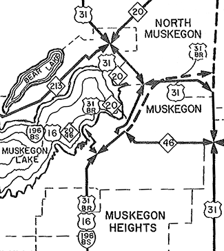 |
|||||||||||||||||||||||||||
| 1962 (Dec 12) – The concurrent US-16/BUS US-31 designation in the Muskegon area becomes BS I-196/BUS US-31 with the decommissioning of US-16 in the state of Michigan. The BS I-196 designation replaces US-16 on the Norton-Glade Expwy (Seaway Dr) between the Sixth St and the western terminus of I-196 at US-31 southeast of Muskegon. (BS I-196 continues replacing US-16 from BUS US-31/Muskegon & Webster Aves northwesterly along Sixth St, Western Ave and Mart St to form a new concurrent BS I-196/M-20/M-46 routing along those streets.) | ||||||||||||||||||||||||||||
| 1963 (Late) – The newly concurrent BS I-196 routing along BUS US-31 is redesignated as BS I-96 when the "parent route" of the Interstate running from Muskegon to Grand Rapids is redesignated from I-196 to I-96. | ||||||||||||||||||||||||||||
| 1964 (Jun 30 ) – A northerly extension of the US-31 freeway from the northeast corner of Muskegon northerly toward Whitehall and Montague is officially established as a state trunkline highway route, although it remains under construction and will not open until late in the year. Until that point, US-31 continues to use Access Highway as a conector between Harvey St and the Veterans Memorial Causeway north of downtown Muskegon where it continues northerly toward Whitehall via Whitehall Rd and BUS US-31 remains on its existing route through downtown Muskegon, terminating at US-31 at the cnr of Ottawa St & Access Hwy (at the present day location of jct BUS US-31 & M-120). | ||||||||||||||||||||||||||||
| 1964 (Oct 31 ) – The new northside BUS US-31 expressway connector between the M-20/Veterans Memorial Causeway junction north of downtown Muskegon and the tri-level interchange with the US-31 Muskegon "East Belt" freeway northeast of the city is finally opened to traffic, known as Skyline Dr and Seaway Dr locally. BUS US-31 is removed from its temporary M-20 (present-day M-120) route and transferred onto the new connector, terminating at US-31 at the triple-decker interchange. |
||||||||||||||||||||||||||||
| 1964 (Dec 3) – A 0.33-mile portion of the BUS US-31/M-20/Skyline Dr (present-day Moses J Jones Pkwy) is completed and opened to traffic between Eastern Ave on the northeast end of downtown Muskegon and Bayou Ave just shy of the South Branch of the Muskegon River. The new segment of four-lane expressway replaces Prospect Ave along its route. Due to settling problems at Ryerson Creek, the northbound and southbound roadways will not be complete until next year when the tons of sand placed by construction crews has a chance to settle. Until the gap between Spring St and Eastern Ave is completed, southbound BUS US-31/M-20 traffic is directed to continue to use the existing route from Bayou Ave southwesterly into downtown via Ottawa St–Eastern Ave–Western Ave–Terrace St. | ||||||||||||||||||||||||||||
| 1965 (Jan 20 ) – The segment of the BUS US-31/Skyline (Seaway) Dr expressway from Bayou Dr through the M-20/Veterans Memorial Causeway junction then easterly to the tri-level US-31 interchange northeast of Muskegon that opened to traffic nearly three months previously is officially established as a state trunkline highway. Simultaneously, the former route of BUS US-31 along Ottawa St from Bayout St northeasterly to the Veterans Memorial Causeway intersection is turned back to city control, as are the segments of 1.) Access Hwy from the dead-end west of Getty St (the portion west of the dead-end is either subsumed under the new BUS US-31 route or obliterated as a public roadway) easterly to the point where it meets the US-31 freeway and 2.) the segment of Harvey St immediately across the US-31 freeway from Access Hwy (about 1,000 south of Stebbins Rd) southerly to a point directly across the freeway from Marcoux Ave. | ||||||||||||||||||||||||||||
| 1965 (Jan 26) – The Muskegon City Commission adopts a resolution to officially name BUS US-31 in its entirety as "Seaway Drive" (noting, however, that the segments of Muskegon and Webster Aves through the downtown core would keep their present identities, though) in order to clarify the designation of the new business route which will be completed this year. The southern portion, from the US-31 & I-96 interchange southeast of the city, northwesterly, westerly and northerly into downtown had orignally been known as the Norton-Glade Expressway, but has been referred to by the Seaway Dr name for a few years now. The northern portion, currently under construction, between downtown and the triple-deck interchange at US-31 northeast of the city, has been most-commonly referred to as "Skyline Drive," a moniker reportedly assigned to it by city planners. | ||||||||||||||||||||||||||||
| 1965 (Jun 9–25) – The final link in the route of Muskegon's BUS US-31 route of Seaway Dr/Skyline Dr is finally completed and opened to traffic on June 9 on the northeast end of downtown Muskegon linking Muskegon and Webster Aves at Spring St with the previously completed expressway portion at Eastern Ave. (This was the portion delayed due to settling problems at Ryerson Creek.) At this point, the M-20 designation is also likely scaled back to terminate at the southern end of the Veterans Memorial Causeway where it meets BUS US-31 north of downtown, resulting in the removal of all M-20 route markers from the route of BUS US-31 between that point through downtown to Sixth St and along US-16/M-46 along Sixth St–Western Ave–Mart St out onto the Mart Dock. These changes are reflected in official establishments and cancellations 16 days later on June 25 when the 1.274-mile segment of BUS US-31 along Muskegon & Webster Aves from First St northeasterly to Spring St and then north-northeasterly along Skyline/Seaway Dr from Spring St to Bayou St is officially established as a state trunkline highway route. At the same time, the 1.038 mile of Ottawa Ave from Bayou St south-southwesterly to Cedar St, then southwesterly along Clay Ave to Terrace St, as well as the two blocks of Terrace St beween Clay St and Muskegon Ave are all cancelled as part of the trunkline route and turned back to city control. The temporarily Marked & Maintained segment which carried southbound BUS US-31 and westbound M-20 traffic along Eastern Ave from Ottawa St to Western Ave and then via Western from Eastern to Terrace St and Terrace St for the one block back to Clay Ave is no longer a marked trukline route for southbound BUS US-31 and westbound M-20 and state maintenance ceases. |
||||||||||||||||||||||||||||
| 1984 – Likely in preparation for the transfer of the BS I-96/M-46 route via Sixth-Western-Mart in downtown Muskegon to local control on April 1, 1986, the BS I-96 route markers along BUS US-31 are completely removed, leaving just BUS US-31 along Seaway Dr. | ||||||||||||||||||||||||||||
| c.1994 – The first segment of Shoreline Dr opens as a local street from BUS US-31/Seaway Dr just north of Southern Ave around the north side of downtown near the Muskegon Lake shoreline to Terrace St. This is the first step in an eventual rerouting of BUS US-31 through Muskegon. | ||||||||||||||||||||||||||||
| 2004 – The final link in the new Shoreline Dr routing is completed and opened to traffic. It will be three more years before the jurisdictional transfer that will swap Shoreline Dr for the existing one-way pair of BUS US-31 through downtown Muskegon is finalized, however. | ||||||||||||||||||||||||||||
| 2007 (July 5) – The long-awaited jurisdictional "swap" in downtown Muskegon takes place. The one-way pair of Muskegon & Webster Aves betwen the intersections with Shoreline Dr is turned back to city control. In total, 1.21 miles of Webster Ave and 1.29 miles of Muskegon Ave are handed to the City of Muskegon. In exchange, MDOT assumes control of the 1.7 miles of Shoreline Dr that bypasses downtown closer to the Lake Muskegon shoreline. | ||||||||||||||||||||||||||||
| 2016 (July 25) – The West Michigan Pike Historic Byway is officially unveiled at a ceremony in Muskegon's Heritage Park. Running from the Indiana state line south of New Buffalo up Michigan's west coast to Ludington, the Byway runs along the segment of Muskegon's BUS US-31 from the southern terminus at US-31 Exit 110 (at jct I-96) in Norton Shores to jct M-120/Veterans Memorial Causeway north of downtown Muskegon | ||||||||||||||||||||||||||||
| Freeway: | 1. From southern terminus at US-31 to Grand Haven Rd in Norton Shores. | |||||||||||||||||||||||||||
| 2. From Getty Ave northeast of downtown Muskegon to northern terminus at US-31. | ||||||||||||||||||||||||||||
| Expressway: | 1. Seaway Dr from Grand Haven Rd to the Muskegon Ave-Webster Ave & Shoreline Dr split just southwest of downtown. | |||||||||||||||||||||||||||
| 2. Skyline Dr from the Muskegon Ave–Webster Ave & Shoreline Dr split notheast of downtown to Getty Ave. | ||||||||||||||||||||||||||||
| NHS: | The entirety of BUS US-31 (Muskegon) is on the National Highway System (NHS). (The Shoreline Dr portion of the route from the Muskegon Ave-Webster Ave split on the southwest edge of downtown to Moses J Jones Pkwy (Skyline Dr) on the northeast edge of downtown was added to the NHS in 2012 with the passage of the MAP-21 funding and authorization bill.) | |||||||||||||||||||||||||||
| Circle Tour: | ||||||||||||||||||||||||||||
| Pure Michigan Byway: | ||||||||||||||||||||||||||||
| Memorial Highway: | The following Memorial Highway designation has been officially assigned to part of M-22 by the Michigan Legislature:
|
|||||||||||||||||||||||||||
| Photographs: | ||||||||||||||||||||||||||||
| Weblinks: | ||||||||||||||||||||||||||||
Whitehall-Montague |
Southern Terminus: | US-31 at the Colby Rd interchange (Exit 128) east of Whitehall | ||||||||||||||||||||||||||
| Northern Terminus: | US-31 at the B-15/B-86/Fruitvale Rd interchange (Exit 131) north of Montague | |||||||||||||||||||||||||||
| Length: | 4.882 miles | |||||||||||||||||||||||||||
| Map: | Route Map of BUS US-31 (Whitehall-Montague) | |||||||||||||||||||||||||||
| Notes: | With the exception of short portions along Colby Rd and Fruitvale Rd at each end of the highway, BUS US-31 follows the former routing of US-31 through the twin cities of Whitehall and Montague. | |||||||||||||||||||||||||||
| History: | 1964 (Jun 30) – The US-31 freeway segment from Muskegon northerly to north of Montague in northwestern Muskegon Co is officially assumed into the state trunkline system on this date and likely opens to traffic at the same time. Existing US-31 along Whitehall Rd from Colby Rd southerly to North Muskegon is transferred to local control, while both Colby Rd from Whitehall Rd easterly to the new US-31 freeway and Fruitvale Rd from Whitehall Rd to the new freeway are transferred to the state as part of a new BUS US-31 routing. From the US-31 freeway, the new BUS US-31 continues westerly via Colby Rd past Whitehall Rd, through Whitehall via Colby St and Thompson Rd, then through Montague via Dowling St and Water St, continuing northerly via Whitehall Rd. At Fruitvale Rd, BUS US-31 officially turns easterly via Fruitvale to a terminus with the new US-31 freeway as well as continues straight northerly via Whitehall Rd for approximately one mile to the new US-31 freeway connector roadway. | |||||||||||||||||||||||||||
| 1975 (Apr 16) – A northerly extension of the US-31 freeway from north of Montague into Oceana Co is officially established and likely opens around this same time. Thus, the Fruitvale Rd routing of BUS US-31 from Whitehall Rd easterly to the US-31 freeway becomes the sole signed route for the highway. What had been signed as part of BUS US-31 via Whitehall Rd from Fruitvale northerly to the freeway connector—which is abandoned and obliterated—as well as the former US-31 from that point notherly to the Oceana Co line remains an unsigned state trunkline highway. | ||||||||||||||||||||||||||||
| 2016 (July 25) – The West Michigan Pike Historic Byway is officially unveiled at a ceremony in Muskegon's Heritage Park. Running from the Indiana state line south of New Buffalo up Michigan's west coast to Ludington, the Byway runs along the entire length of Whitehall-Montague's BUS US-31 routing. | ||||||||||||||||||||||||||||
| Freeway/Expwy: | No portion of BUS US-31 is freeway or expressway. | |||||||||||||||||||||||||||
| NHS: | The entirety of BUS US-31 (Whitehall-Montague) is on the National Highway System (NHS). (The route was added to the NHS in 2012 with the passage of the MAP-21 funding and authorization bill.) | |||||||||||||||||||||||||||
| Circle Tour: | ||||||||||||||||||||||||||||
| Pure Michigan Byway: | ||||||||||||||||||||||||||||
| Photographs: | ||||||||||||||||||||||||||||
| Weblinks: | ||||||||||||||||||||||||||||
Hart |
Fmr. West Terminus: | US-31 at Polk Rd interchange (Exit 149) southwest of Hart | ||||||||||||||||||||||||||
| Fmr. East Terminus: | Cnr State St & Johnson St in downtown Hart | |||||||||||||||||||||||||||
| Former Length: | 2.349 miles | |||||||||||||||||||||||||||
| Map: | ||||||||||||||||||||||||||||
| Notes: | ||||||||||||||||||||||||||||
| History: | 1975 (Apr 16) – Even though the new US-31 freeway is over a year from completion in central Oceana Co, a new trunkline spur routing is established at Hart, beginning at the proposed freeway interchange with Polk Rd west of the city proceeding easterly via Polk Rd to State St, then northerly via State to Lincoln St. The existing US-31 bypass of Hart remains signed as US-31 and it is likely no BUS US-31 signs appear at Hart at this time. | |||||||||||||||||||||||||||
| 1976 (Dec 14)– The next segment of the US-31 freeway is completed and opened to traffic from M-20 at New Era to Polk Rd at Hart. Traffic is shunted off the new freeway and directed easterly via Polk Rd to the existing US-31/Oceana Dr routing. (The 0.37 mile of Polk Rd from State St easterly to Oceana Dr would be transferred to the state on March 23, 1977 as a "temporary measure"—this route is still an unsigned state trunkline as of of today.) It is unclear whether the State St route of BUS US-31 from Polk Rd northerly to Lincoln St is posted as BUS US-31 in the field at this time. | ||||||||||||||||||||||||||||
| 1978 (Sept 29) |
||||||||||||||||||||||||||||
| 1988 – BUS US-31 at Hart appears on the Official Michigan Transportation Map for the first time this year. | ||||||||||||||||||||||||||||
| 1989 (Aug 14) – Two blocks of BUS US-31 in downtown Hart are cancelled as a state trunkline route and transferred to local control. The 0.12-mile portion of State St from Lincoln St southerly to Johnson St becomes a city street moving BUS US-31's terminus to the cnr of State St & Johnson St. | ||||||||||||||||||||||||||||
| 2025 (June 26) |
||||||||||||||||||||||||||||
| Freeway/Expwy: | No portion of BUS US-31 (Hart) was freeway or expressway. | |||||||||||||||||||||||||||
| Photographs: | ||||||||||||||||||||||||||||
| Weblinks: | ||||||||||||||||||||||||||||
| | ||||||||||||||||||||||||||||
Pentwater |
Fmr. So. Terminus: | US-31 at the Monroe Rd interchange (Exit 154) southeast of Pentwater | ||||||||||||||||||||||||||
| Fmr. No. Terminus: | US-31 at the Oceana Dr interchange (Exit 158) northeast of Pentwater | |||||||||||||||||||||||||||
| Former Length: | 7.279 miles | |||||||||||||||||||||||||||
| Map: | Route Map of FORMER BUS US-31 (Pentwater) | |||||||||||||||||||||||||||
| Notes: | BUS US-31 at Pentwater followed a former routing of US-31 through the village which was commissioned along the the former US-31 in 1955 when a bypass of the village was completed along present-day Oceana Dr between Monroe Rd and the Oceana/Mason Co line. | |||||||||||||||||||||||||||
| History: | 1955 (July 12, Aug 3) |
|||||||||||||||||||||||||||
| 1976 (Dec 14) – A segment of US-31 freeway from Polk Rd at Hart to BUS US-31/Monroe Rd east of Pentwater is established as a state trunkline on this date, but will not open to traffic for a couple more years. Thus, the BUS US-31 routing via Monroe Rd continues to run easterly to existing US-31/Oceana Dr. | ||||||||||||||||||||||||||||
| 1978 – The segment of US-31 freeway officially established in late-1976 opens to traffic. The route of BUS US-31 is shortened by approximately one mile to end at the new Monroe Rd interchange. The former BUS US-31 along Monroe Rd from the new freeway easterly to Oceana Dr becomes a temporary routing for mainline US-31 traffic. | ||||||||||||||||||||||||||||
| 1978 (Sept 29) |
||||||||||||||||||||||||||||
| 1980 (Nov 6) |
||||||||||||||||||||||||||||
| 2016 (July 25) – The West Michigan Pike Historic Byway is officially unveiled at a ceremony in Muskegon's Heritage Park. Running from the Indiana state line south of New Buffalo up Michigan's west coast to Ludington, the Byway runs along the entire length of Pentwater's BUS US-31 routing. | ||||||||||||||||||||||||||||
| 2023 (May 4) |
||||||||||||||||||||||||||||
| 2023 (May 18) |
||||||||||||||||||||||||||||
| 2023 (Fall) |
||||||||||||||||||||||||||||
| Freeway/Expwy: | No portion of Former BUS US-31 (Pentwater) was freeway or expressway. | |||||||||||||||||||||||||||
| Circle Tour: | ||||||||||||||||||||||||||||
| Pure Michigan Byway: | ||||||||||||||||||||||||||||
| Photographs: | ||||||||||||||||||||||||||||
| Weblinks: | • BUS US-31 (Pentwater) @ Michigan Highway Ends – photos of the termini of BUS US-31 (Pentwater) at Dan Garnell's archived Michigan Highway Ends website. | |||||||||||||||||||||||||||
Ludington |
Southern Terminus: | US-31 at the Pere Marquette Hwy interchange (Exit 166) southeast of Ludington | ||||||||||||||||||||||||||
| Northern Terminus: | US-10 on the east limits of Ludington (See Note below.) | |||||||||||||||||||||||||||
| Length: | 3.237 miles | |||||||||||||||||||||||||||
| Map: | Route Map of BUS US-31 (Ludington) | |||||||||||||||||||||||||||
| Notes: | This particular BUS US-31 follows the former route of US-31 in the Ludington area. | |||||||||||||||||||||||||||
| History: | 2004 – When the segment of the US-31 freeway on the east side of Ludington in 1990, all of the former route of US-31 in Mason county was retained as an unsigned state trunkline highway. Then in 2004, the portion of Pere Marquette Hwy (Old US-31) from the US-31 & Pere Marquette interchange southeast of Ludington southerly to the north Pentwater interchange on the Oceana/Mason Co line is turned back to local control, leaving the portion of Pere Marquette from the US-31 interchange northerly on the state trunkline system. | |||||||||||||||||||||||||||
| 2005 (Spring) – A brand-new BUS US-31 designation is signed for the first time along Pere Marquette Hwy, the former route of US-31, on the east side of Ludington, from the Pere Marquette Hwy interchange along the US-31 freeway northerly to US-10. As of early May 2005, BUS US-31 route marker assemblies are posted along the new route, but not along the intersecting highways. It is also unclear if MDOT will sign this new route as a spur, terminating on the north at US-10, or as a full loop, by co-signing it along US-10 between Pere Marquette Hwy and the US-31 freeway interchange. | ||||||||||||||||||||||||||||
| Freeway/Expwy: | No portion of BUS US-31 (Ludington) is freeway or expressway. | |||||||||||||||||||||||||||
| Photographs: | ||||||||||||||||||||||||||||
| Weblinks: | ||||||||||||||||||||||||||||
|
|
||||||||||||||||||||||||||||