

| Back to Previous Route: M-71 |
 |
On to Next Route: M-73 |
| Western Terminus: | Empire at M-22 |
| Eastern Terminus: | US-23 in Harrisville (cnr Main St & State St) |
| Length: | 156.576 miles |
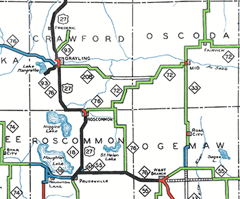
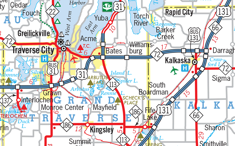
| Maps: | Route Map of M-72 |
| Notes: | One of only three cross-peninsular "M-numbered" state highways in the Lower Peninsula. The others are M-46 (Muskegon-to-Port Sanilac) and M-55 (Manistee-to-Tawas City). |
| M-72 between Grayling and Traverse City is a heavily-travelled corridor, carrying travellers between downstate areas and the Grand Traverse region. Because of this, the highway is slowing being upgraded, with several miles of new passing lanes completed over the past couple decades. More development along the corridor plus additional growth around Traverse City may prompt more upgrades to come. One upgrade, a direct connection between M-72 & I-75 in Grayling, had been studied in the past, but no action has been taken to date. | |
| M-72 started as a short highway in Alcona Co, beginning near Lincoln and heading easterly into Harrisville, before turning southerly to follow the Lake Huron shoreline to Greenbush. Over the years, M-72 was extended westerly in spurts, first in 1923, then again in 1927, 1932, and 1940, when it replaced the M-76 designation west of Grayling. Further extensions in 1946 and 1947 completed the highway from coast-to-coast. | |
However, beginning in c.1945, the State Highway Dept began signing the Leelanau Co gap as part of M-72 so that Empire to Traverse City were finally connected by a signed state highway route. Two years later, the Acme–Kalkaska gap was similarly signed along existing county roads, even though those roads remained under county jurisdiction. This was done to help the motoring public as traffic in the corridor grew considerably following World War II. The state and counties came to an agreement to sign the two gaps as part of M-72 but leaving them technically as county roadways with the counties continuing to pay for the level of maintenance the sections had received the year prior to their being signed as trunkline segments. The State Highway Dept contributed additional funding and resources above and beyond that as needed. According to State Highway Commissioner Charles Ziegler, while the Grand Traverse portion of the Acme–Kalkaska gap was already paved, "the section in Kalkaska County was etirely gravel surface. We agreed to alleviate the dust nuisance and put on regular amounts of chloride on the Kalkasa gravel section to make this section more travelable. We also at times, when we had a truck or two available, hauled in some new gravel to improve some locations in Kalkaska County which got pretty bad." Unfortunately, for the general public, seeing the two gaps marked on official state highway maps through the 1950s as being part of the overall M-72 route, it was not clear they were not technically under state jurisdiction which correlated to the the lower-quality of those segments. Ziegler noted one of the hold-ups on the Acme–Kalkaska section was a somewhat-contentious proposed "Kalkaska Jet Base" (Air Force Base) would have been located atop the approved alignment, meaning any construction work done and funding used on that segment would have been lost and a new route to the south would have needed to be built. (However, one would assume the Federal government would have paid for the relocation of M-72 as part of the base construction in that case.) The proposed "Jet Base" was originally intended to be built in Benzie or Grand Traverse Cos, but an agreement to construct it at least 15 miles away from the Interlochen Center for the Arts to limit noise at the camp turned the facility into a political football and was actively sought after by Antrim, Kalkaska, Cadillac, and Manistee interests during the 1954–55 timeframe. The Kalkaska site was the one deemed the most desirable by the Air Force which would have begun at the Grand Traverse/Kalkaska Co line on the west, come within two miles of Kalkaska on the east and begin approximately 1½ miles of M-72 on the north. Ultimately, however, the proposed air force base was moved to a site in Manistee Co before being shelved completely. As the base was never built, construction on a permanent route for M-72 in the area went ahead in the late 1950s. |
|
In "State Trunkline Needs, 1960–1980," a set of maps prepared by the State Highway Dept's Office of Planning, Programming Division in 1960 showing possible additions, upgrades and improvements to the state trunkline system over the ensuing twenty years, MSHD staff recommended one major change and two smaller ones to the route of M-72 during that timeframe, including:
|
|
| History: | 1917 (Feb 19) – A 10.8-mile long segment of highway is officially established as a state trunkline route beginning at the cnr of F-30/Mikado Rd & Cedar Lake Rd in the community of Greenbush in southeastern Alcona Co and continuing northerly, in part, on present-day Everett Rd, Huron Shore Rd (present-day US-23) and State St into downtown Harrisville. From there, the trunkline route turns due westerly via Main St and present-day M-72, continuing westerly from the west village limit of Harrisville for six more miles to a terminus at T.L. 10 (later M-10, US-23 and M-171, now F-41) south of Lincoln. This trunkline segment is assigned the designation of T.L. 72 (Trunk Line 72). |
| 1919 (July 1) – T.L. 72 is signed in the field as M-72 as all state trunkline highways in Michigan are signed with route markers. | |
| 1922 (Jan 31) – A 10.6-mile westerly extension of M-72 is officially established as a state trunkline route beginning at the former west terminus of M-72 at M-10 (now F-41) south of Lincoln and ending at O'Donnell Rd southwest of Barton City. | |
| 1924 (May 23) – An additional 5.2-mile state trunkline highway route is established as an extension of M-72, beginning at the eastern terminus of M-72 in Greenwood and continuing southerly via Cedar Lake Rd to Cedar Lake Dr, continuing down the east side of Cedar Lake, terminating at the Alcona/Iosco Co line. Based on maps, this extension of M-72 may not be signed in the field at this time. | |
| 1924 (July 19) – Only two months after and extension of the route of M-72 is officially designated from Greenwood southerly to the Alcona/Iosco Co line, the southernmost 4.1 miles of the route is cancelled as a trunkline and turned back to County control, which includes all of the Cedar Lake Dr route and the portion of Cedar Lake Rd from Cedar Lake Dr northerly to Smith Rd. Simultaneously, a 4.1-mile extension/relocation of M-72 is officially established following Cedar Lake Rd southerly from Smith Rd on the west shore of Cedar Lake, terminating at the Alcona/Iosco Co line. | |
| 1927 (Feb 7) – Just 2½ years after the cancellation of the M-72 route on the east shore of Cedar Lake in Alcona Co and the simultaneous establishment of the route on the west shore of the lake, the entire 4.1-mile 1924 routing for M-72 along Cedar Lake Dr from Smith Rd southerly is cancelled as a trunkline route and turned back to County control. At the same moment, a brand-new 10.2-mile new trunkline route is established from Cedar Lake Dr at approximately Smith Rd, then southeasterly to the present alignment of US-23, continuing southerly paralleling the Lake Huron shore into Iosco Co, to a new terminus at jct US-23 (formerly M-10) on the northern outskirts of Oscoda. | |
| c.1927 (Sept 9) – M-72 is subtantially extended from its western terminus near Barton City in central Alcona Co, westerly through Curran and Hardy and into Oscoda Co to Fairview where it meets M-33. (This segment of M-72 is apparently not yet officially established as a state trunkline route at this time, but only a "marked-and-maintained" route until officially established.) From Fairview to Mio, M-72 runs concurrently with M-33 via Miller, Knepp, Kneeland, and Mount Tom Rds. M-72 then supplants the former route of M-33 (which is transferred to run southerly from Mio via the existing route of M-97) from Mio through Luzerne and into southeastern Crawford Co to a terminus at M-76 approximately 6½ miles east of Rocscommon. | |
| 1932 (Oct 29) – A new, more direct alignment for M-72 is established in Crawford Co, southwest of El Dorado. The new 4.5-mile route begins at the corner of Brush Rd & present M-18 and continues southwesterly along present-day M-18 to Hunters Lake Rd, then westerly via Hunters Lake Rd to Forester Rd, southerly on Forester Rd to a terminus at M-76 on the Crawford/Roscommon Co line. The former 5.5 mile route along Brush Rd westerly to the former Hickey Creek Rd, the now-obliterated Hickey Creek Rd southwesterly to the still-extant Hickey Creek Rd to Forester Rd, Forester Rd southerly to Hall Rd, westerly and southwesterly along Hall Rd to Pioneer Rd, Pioneer Rd westerly to Willows Rd, and Willows Rd southerly to a terminus at M-76 is cancelled and turned back to county control. | |
| 1933 (July 12) – Even though M-72 from central Alcona Co via Curran and Hardy to M-33 in downtown Fairview in Oscoda Co has appeared on official highway maps since c.1927, that route was never officially established as a state trunkline route until now. Continuing west from O'Donnell Rd southwest of Barton City in Alcona Co, the officially-established route of M-72 continues due westerly for 3½ miles, then northwesterly vua Grosse Pointe Rd and the present-day M-65/M-72 corridor to Reeves Rd, northerly along Reeves Rd for a mile to Tower Rd, westerly via Tower Rd for a mile to Curran, northerly again along present-day M-65/M-72 for a mile to Flynn Corners, then westerly for 4 miles along present-day M-72 to Hardy on the Alcona/Oscoda Co line. From Hardy, M-72 continues into Oscoda Co on a due westerly alignment mostly along existing roadyway (with the exception of a 1½ mile stretch over Waterhole Hill approximately three miles west of Hardy) including Oaks Rd to Weaver Rd, northerly ½ mile on Weaver Rd, then west one mile on Miller Rd to M-33 in Fairview. M-72 then continues on the route it's been signed along since c.1927. | |
| 1935 (Jan 7) – The 4.5-mile segment of M-72 in southeastern Crawford Co established as a state trunkline in October 1929 is cancelled and turned back to county control. Simultaneously, a new 5.5-mile trunkline routing for M-72 is assumed into the trunkline system beginning at Brush Rd & present-day M-18 and continuing westerly along Brush Rd for ½ mile, then southerly along an unconstructed facility and present-day F-97/Co Rd 502, then westerly via Dry Lake Rd and Hall Rd to the existing route of M-72 at Forester Rd. | |
| 1936 (Aug 20) – The remainder of the new shoreline routing of US-23 between Oscoda and the Alpena/Alcona Co line is completed and opened to traffic north of Harrisville. At this point, the US-23 designation is transferred onto the new Oscoda–Greenbush–Harrisville–Ossineke route, supplanting the portion of M-72 from Oscoda via Greenbush to Harrisville. The new eastern terminus for M-72 is now at US-23 in Harrisville. | |
| 1937 (Aug 30) – A 0.6-mile easterly extension of M-72 is officially established as a state trunkline route in Harrisville. From the eastern terminus of M-72 at US-23/State St, M-72 now continues easterly via Main St for 4 blocks to Huron Ave, then turns southerly via Huron Ave to a new terminus a the entrance to Harrisville State Park. | |
| 1937 (Dec 29) – The new alignment for M-72 in southeastern Crawford Co established in January 1935 is cancelled and the existing roadway segments are turned back to county control. Ironically, the "new" established route for M-72 is the one from October 1932 that was cancelled in January 1935—essentially a reversal of the January 1935 change! M-72 again runs southwesterly from Brush Rd via present-day M-18, then westerly along Hunters Lake Rd, and southerly via Forester Rd. | |
 1940 (Nov 12) – The route of M-72 is drastically altered from Luzerne in Oscoda Co westerly. From Luzerne, M-72 now runs westerly along a newly-(re-)established state trunkline routing which had formerly been a route designated as M-208 from January 1935 until November 1939. The route of M-208 had only been signed/completed from US-27 at Grayling to Smith Bridge spanning the South Branch (of the Au Sable) River, whereas the remainder was only an officially-designated route, not actually signed in the field. Now, however, the newly re-designated route from Luzerne westerly for 12.2 miles runs along a curvy, "earth-surfaced" roadway to Smith Bridge where it transitions to use the former 13.3 miles of M-208 from there to US-27 at Grayling. The former routing of M-72 southwesterly from Luzerne to M-76 east of Roscommon is retained as a state trunkline and redesignated as M-144. From US-27 in Grayling heading westerly for 24 miles to M-66 south of Kalkaska, the M-72 designation replaces, ironically, the M-76 designation along the route. 1940 (Nov 12) – The route of M-72 is drastically altered from Luzerne in Oscoda Co westerly. From Luzerne, M-72 now runs westerly along a newly-(re-)established state trunkline routing which had formerly been a route designated as M-208 from January 1935 until November 1939. The route of M-208 had only been signed/completed from US-27 at Grayling to Smith Bridge spanning the South Branch (of the Au Sable) River, whereas the remainder was only an officially-designated route, not actually signed in the field. Now, however, the newly re-designated route from Luzerne westerly for 12.2 miles runs along a curvy, "earth-surfaced" roadway to Smith Bridge where it transitions to use the former 13.3 miles of M-208 from there to US-27 at Grayling. The former routing of M-72 southwesterly from Luzerne to M-76 east of Roscommon is retained as a state trunkline and redesignated as M-144. From US-27 in Grayling heading westerly for 24 miles to M-66 south of Kalkaska, the M-72 designation replaces, ironically, the M-76 designation along the route.Additionally, more than 36 miles west of Kalkaska, the route of M-76 designated from M-22 on the west edge of Traverse City to M-22 in Empire is also redesignated as M-72, although at this point, only the first 7.4 miles of the route from Empire easterly to Fritz Rd in south central Leelanau Co is actually signed as M-72 (formerly M-76), while the remainder of the 22.0-mile route (14.6 miles of it) from Fritz Rd easterly to Traverse City is officially designated but not completed or signed in the field. M-72 is now a two-segment, discontinuous route. |
|
| 1941 (May 14) – The officially-established route of M-72 in extreme southeastern Leelanau Co is altered, even though this portion of the route does not appear on official highway maps and all sources indicate this portion of the route is not signed in the field. Formerly designated to travel northeasterly then generally easterly along Carter Rd from its present-day alignment to M-22 in downtown Greilickville, then southerly with M-22 into Traverse City, the officially-established (yet unsigned) route moves to its present-day alignment from Carter Rd to M-22 on the Grand Traverse/Leelanau Co line. The former toute along Carter Rd is transferred back to county control. It would be an additional six years before this route was actually completed and signed as part of M-72. | |
1942 (Aug 17) – Two relatively minor changes are made to the yet unsigned portion of M-72 in southeastern Leelanau Co west of Traverse City:
|
|
| 1946 – During 1946, a 5.3-mile long segment of the officially-established (but still unsigned) route of M-72 in southern Leelanau Co from Ruthardt Rd easterly to the Solon/Elmwood Twp line is graveled and the State Highway Dept, thus, considers the entire Empire–Traverse City portion of the route to meet state trunkline standards and now signs the entire segment as part of M-72. (The Empire–Traverse City segment had been officially established as a state trunkline route in 1935 as part of the route of M-76, but was ony signed over the westernmost 4.7 miles of the route running easterly out of Empire. | |
| 1947 (June 15) |
|
| 1949 (Nov 10) – Two new segments of M-72 are officially established southern Leelanau Co west of Traverse City, bypassing a total of four sharp turns in the route. An 0.8-mile segment of new highway bypasses a 1.1-mile long segment of the former route from ½ mile east of Cedar Rd to present-day Partridge Run Dr. The segments of former M-72 east and west from Cedar Rd are obliterated as public roadways, while the portion of Cedar Rd making up part of the former route of M-72 is cancelled and turned back to county control. Just to the west, a 1.8-mile segment of highway on new alignment similarly bypasses a 2.4-mile segment of the former route from Cedar Valley Rd westerly to Ruthardt Rd. While the new construction obliterates a segment of the former route between Cedar Run and Tager Rds, the remainder of the former route along Cedar Valley, Cedar Run, Tager and Ruthardt Rds is turned back to county control. | |
| 1951, 1952 (Nov 10) – In late 1951, both M-72 and M-33 are realigned onto their present routing between Mio and Fairview, although the official jurisdictional changes will not occur for over a year until Nov 10, 1952. At that time, the 4.0 miles of Miller Rd from Knepp Rd westerly to Mount Tom Rd and Mount Tom Rd from Miller Rd southerly to Kneeland Rd is transferred to state control (having been "Marked and Maintained" as M-33/M-72 for over a year), while Knepp Rd from Miller Rd to Kneeland Rd and Kneeland Rd from Knepp Rd westerly to Mount Tom Rd is turned back to county control. | |
| 1952 (Nov 11) |
|
| 1953 (Nov 6) |
|
| 1954 (Jan 4) – M-65/M-72 is realigned from Curran southerly and easterly with the establishment of 3.0 miles of new trunkline route, replacing 3.2 miles of former route mileage. The former route running easterly from the community of Curran via Tower Rd for one mile, then southerly along Reeves Rd for one mile is turned back to County control, while the portion easterly and southeasterly from Reeves Rd is obliterated as a public roadway. | |
1957–1958 – Seventeen years after it was designated over the Luzerne-to-Smith Bridge route in western Oscoda and eastern Crawford Cos, the 9.1-mile stretch of M-72 is cancelled and immediately re-designated on on a different but generally parallel route also totalling 9.1-miles, over the course of two construction seasons:
|
|
| 1958 (Sept 16–Mid Nov) |
|
| 1959 (Mid June) |
|
1959 (Nov 6) – A trio of changes come to the route of M-72:
|
|
| 1961 (Jan 3) – The 3.6-mile portion of M-72 in Oscoda Co from the Lost Creek bridge, approximately 5 miles west of Mio, to CR-489/Deter Rd & CR-490 in Luzerne is cancelled as a state trunkline highway route, replaced by a new 3.4-mile routing along its present alignment (Cripps Rd). A portion of the new highway alignment—between approximately Lenroy Valley and Gorton Rds—lies atop the original alignment, while the remainder is new construction. The two remaining segments of the former route along CR-489/Park Rd, Lenroy Valley Rd and Gorton Rd are turned back to county control. This project also paves the last several miles of gravel-surfaced M-72 between Luzerne and Mio. | |
| 1961 (Oct 27)–1962 (May 1) |
|
| 1963 (June 28) – The 0.6-mile easterly extension of M-72 along Main St and Huron Ave in Harrisville officially designated in 1937 to serve the main entrance of Harrisville State Park is cancelled as a state trunkline route and turned back to village control. The Harrisville State Park main entrance is now off US-23 south of town. | |
| 1966 (Mid Nov–Dec 13) |
|
| 1974 (Jan 7) – M-66/M-72 is realigned on the south side of Kalkaska onto a 0.78-mile long new highway constructed as a continuance of M-72 westerly from M-66 to US-131 southwest of downtown. M-66/M-72 then continues northeasterly via US-131 into downtown to the highways' former alignment. The former routing of M-66/M-72 via (present-day) Old M-66 and Court and Elm Sts is retained as an unsigned state trunkline highway route for now. | |
| 1978 – Michigan's only "runaway truck ramp" (or, as MDOT calls it, a "truck trap") is constructed on M-72 west of Traverse City, west of the junction with M-22. The cost of this "truck trap" is $66,400, as lies near the bottom of Morgan Hill, a long down-grade. Beyond the ramp is a busy intersection with M-22 and the West Arm of the Grand Traverse Bay. | |
| 1996 (June 28––Sept 17) |
|
| Controlled Access: | No portion of M-72 is freeway or expressway. |
| NHS: | The portion of M-72 from jct US-31, M-22, M-37 & M-72 in Traverse City (at cnr Grandview Pkwy & Division St) to southern jct of BL I-75 in Grayling is on the National Highway System (NHS). |
| Circle Tour: | |
| Memorial Highway: | The following Memorial Highway designation has been officially assigned to part of M-72 by the Michigan Legislature:
|
| Photographs: | |
| Weblinks: |
|
| Back to M-71 | Route Listings Home | On to M-73 |