

Polar–Equator Trail
 The
following information was excerpted from a Michigan Polar-Equator Club
brochure from the 1990s. Additional information and photographs are planned
for this page in the future. Some sources claim the Michigan
Polar-Equator Club became defunct in the year 2000 and many of their trail markers
have fallen into serious disrepair over the years.
The
following information was excerpted from a Michigan Polar-Equator Club
brochure from the 1990s. Additional information and photographs are planned
for this page in the future. Some sources claim the Michigan
Polar-Equator Club became defunct in the year 2000 and many of their trail markers
have fallen into serious disrepair over the years.
In January 1965, the Michigan Polar-Equator Club was established on the campus of Michigan State University.
One of the objectives of the MP-EC was to establish and maintain a trail across the State of Michigan as close to the 45th Parallel as possible. The 45th Parallel crosses Michigan from east to west starting just south of Alpena, through just south of Gaylord in central Michigan, then crosses through the Jordon [sic] River valley and across beautiful Torch Lake.
 Near the west side of Torch Lake is a 12-foot cairn, erected in 1938,
on the 45th Parallel. Constructed with native stone, each of the 83 counties
in Michigan is represented by having its name carved on a stone. There
is also one piece of granite from Brunswick, Georgia. The 45th Parallel
continues west across Grand Traverse Bay through Leelanau County near the
communities of Suttons Bay and Leland. The 45th also touches the southernmost
point of South Manitou Island, 15 miles west, in Lake Michigan.
Near the west side of Torch Lake is a 12-foot cairn, erected in 1938,
on the 45th Parallel. Constructed with native stone, each of the 83 counties
in Michigan is represented by having its name carved on a stone. There
is also one piece of granite from Brunswick, Georgia. The 45th Parallel
continues west across Grand Traverse Bay through Leelanau County near the
communities of Suttons Bay and Leland. The 45th also touches the southernmost
point of South Manitou Island, 15 miles west, in Lake Michigan.
In February 1971, the House and Senate of the State of Michigan recognized the Michigan Polar-Equator Trail as a significant tourist attraction in Michigan.
The State of Michigan is about 135 miles wide at the lattitude of the 45th Parallel, but the Polar-Equator Trail is a little longer than that. Torch Lake, some rivers, wetlands and the lack of roads makes it impossible to travel to east to west. So, there are a few jogs in the Trail.
You may notice that many of the mile marker signs now have Bluebird houses mounted on them. This is a project supported by the MP-EC to help promote preservation of the "Trail signs." The MP-EC Trail mile marker signs and Bluebird houses have been installed and maintained exclusively through the financial and volunteer efforts of the members of the Michigan Polar-Equator Club. There is a 20-page Trail book available to help guide you mile by mile across the State of Michigan along the 45th Parallel. The guidebook highlights the interesting sites that you will find along the Trail. The guidebook was also edited and printed through the volunteer and financial efforts of the Michigan Polar-Equator Trail Club.
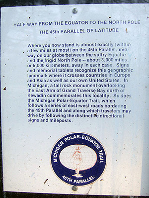 The sign shown in the image at right was found posted at the Fife Lake State Roadside Park on US-131 just north of Fife Lake in May 2008. (It's unclear if the sign is still posted or not at present.) When the photo was taken, the Michigan Polar-Equator Club had not been in existence for 8 years.
Included below are the last two known mailing addresses for the Michigan Polar-Equator Club. Sources claim the club became defunct in the year 2000, just 35 years after it was first formed.
Michigan Polar-Equator Club
Department of Zoology
203 Natural Science Building
Michigan State University
East Lansing, Michigan 48824-1115
Michigan Polar-Equator Club
5 Mueller Ct
Frankenmuth, Michigan 48734
Additional Information
- The 45th Parallel: Cairn Highway, Michigan – a short page from Matt Bergstrom's "45th Parallel" page in his Minnesota Museum of the Mississippi with some photos of the cairn along Cairn Hwy north of Elk Rapids.
- A Fine and Pointless Trail – a great posting on Watermichigan's Blog about the history of the trail and how much of it you can still follow today.
- In Michigan, drive a crooked line to follow the 45th Parallel, equidistant from the equator and North Pole
 – an archived May 10, 2009 article from the Detroit Free Press by travel writer Ellen Creager, who followed the old route across the Lower Peninsula and talked to a few folks along the way.