| Western Terminus: |
 Cnr Michigan Ave & Detroit St in the City of Lansing, approximately 497 feet west of the centerline of US-127 sbd Cnr Michigan Ave & Detroit St in the City of Lansing, approximately 497 feet west of the centerline of US-127 sbd |
| Eastern Terminus: |
M-43/Grand River Ave in downtown East Lansing just west of Abbot St |
| Length |
 1.386 miles 1.386 miles |
| Maps: |
Route Map of M-143 |
| Notes: |
 M-143, a rather short state trunkline route linking US-127 in the eastern portion of the City of Lansing with M-43/Grand River Ave in downtown East Lansing, has had a rather interesting and complex history as a trunkline route designation, even dating back to before the iteration of the route as a spur highway serving the original Cheboygan State Park—which is not the present-day Cheboygan State Park. In late 1929, a new state trunkline route was established across northern Osceola Co between US-131 at Tustin and M-66 at Marion, although no evidence of this route being signed in the field has been uncovered to date. This first iteration of M-143 only lasted a year at most, with it becoming an easterly extension of M-53 by the end of 1930. M-143, a rather short state trunkline route linking US-127 in the eastern portion of the City of Lansing with M-43/Grand River Ave in downtown East Lansing, has had a rather interesting and complex history as a trunkline route designation, even dating back to before the iteration of the route as a spur highway serving the original Cheboygan State Park—which is not the present-day Cheboygan State Park. In late 1929, a new state trunkline route was established across northern Osceola Co between US-131 at Tustin and M-66 at Marion, although no evidence of this route being signed in the field has been uncovered to date. This first iteration of M-143 only lasted a year at most, with it becoming an easterly extension of M-53 by the end of 1930. |
| |
 The second iteration of M-143—and the first one to be definitely signed in the field—debuted in mid-1931 serving the original Cheboygan State Park, which itself was established a decade prior on E Lincoln Ave in the City of Cheboygan. M-143 begame a spur highway serving to connect the park with the rest of the state highway system at US-27/Main St (present-day M-27). This 0.9-mile trunkline even outlasted its sole reason for existence, when this first Cheboygan State Park was sold to Cheboygan County for use as the location for the County Fair in 1945—and is still the location of the Cheboygan County Fair to this day. A decade-and-a-half later, M-143 was finally cancelled as a state trunkline in 1960 and turned back to city control, which brought about the end of the second iteration of the route. The second iteration of M-143—and the first one to be definitely signed in the field—debuted in mid-1931 serving the original Cheboygan State Park, which itself was established a decade prior on E Lincoln Ave in the City of Cheboygan. M-143 begame a spur highway serving to connect the park with the rest of the state highway system at US-27/Main St (present-day M-27). This 0.9-mile trunkline even outlasted its sole reason for existence, when this first Cheboygan State Park was sold to Cheboygan County for use as the location for the County Fair in 1945—and is still the location of the Cheboygan County Fair to this day. A decade-and-a-half later, M-143 was finally cancelled as a state trunkline in 1960 and turned back to city control, which brought about the end of the second iteration of the route. |
| |
Then in 1962, when I-96 was completd around the Greater Lansing area, M-43 was rerouted between Lansing and East Lansing to follow the former route of US-16, leaving the segment formerly designated as part of M-43 along Michigan Ave between downtown Lansing and downtown East Lansing needing a trunkline designation, which then became M-143. Soon after, the Dept of State Highways requests the City of Lansing take over jurisdiction of M-143, but the City refused. But with the coming of the Capitol Loop through downtown Lansing in 1989, the City agreed to swap that rotue to the state in exchange for the City taking over the route of M-143 from nbd BL I-96/BUS US-27/Larch St easterly to the East Lansing city limit. However, the City of East Lansing never took over its portion of M-143 along Michigan Ave from the Lansing city limit easterly to M-43/Grand River Ave, leaving it as an unsigned state trunkline route designated internally within MDOT as "OLD M-143" beginning in 1989. Then, in 2013, MDOT reversed course and actually re-signed the remaining segment of M-143 within East Lansing, even though it has a "non-standard" western terminus at the city limit. This was finally remedied in 2024 when the City of Lansing and MDOT (partially) reversed the 1989 transfers: The Capitol Loop (1989–2024) was transferred to city jurisdiction, while the portion of Michigan Ave from Detroit St just west of US-127 easterly to the Lansing/East Lansing city limit was transferred back to state control after 35 years of being under municipal control, meaning M-143 now had two logical termini: US-127 on the west and M-43 on the east. |
| |
From the point when OLD M-143 was re-signed as M-143 in the field in 2013 until its westerly extension to US-127 in 2024, the western terminus of M-143 existed in two places. This was because the portion of Michigan Ave within the City of Lansing had been transferred to municipal control, but the portion in East Lansing was not. Since the Lansing/East Lansing city boundary actually runs down the median of Michigan Ave for approximately 700 feet, where it crossed the eastbound lanes differs from where it crosses the westbound lanes. Thus the western terminus of M-143 along the westbound side of Michigan Ave was approximately 125 feet west of Highland Ave, while the western terminus of the eastbound side was, of course, 700 feet farther to the west or about 825 feet west of Highland Dr. This meant the length of M-143 was 0.936 mile when measured in the eastbound lanes but just 0.826 mile long when measured in the westbound lanes. Due to the 2024 cancellation of the Capitol Loop in downtown Lansing and the re-extension of M-143 along Michigan Ave from the Lansing/East Lansing city limit westerly through the US-127 interchange, the route once again had one overall length |
| |
"State Trunkline Needs, 1960–1980," is a set of maps prepared by the State Highway Dept's Office of Planning, Programming Division in 1960 showing possible additions, upgrades and improvements to the state trunkline system over the ensuing twenty years. While current iteration of M-143 didn't yet exist in 1960, MSHD staff showed the route of M-43 along Michigan Ave from US-27/M-78/Larch St easterly to US-16/Grand River Ave as a candidate for jurisdictional transfer. Interestingly, 29 years later, the portion in the City of Lansing would be turned back, while the East Lansing segment never was, which eventually led to its re-signing in 2013 and then extension abck into the City of Lansing to US-127 in 2024. |
| History: |
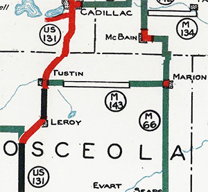
1929 (Dec 8) – A 14.7-mile long route is officially established as a state trunkline highway in Osceola Co along 20 Mile Rd from US-131/Mackinaw Trl just east of Tustin to M-66/Mill St in downtown Marion. It is initially designated as M-143, although it is not clear whether it is actually signed as such in the field. |
| |
1930 (Late) – At some point in the last half of 1930, the designation of the new M-143 route in northern Osceola Co from US-131 near Tustin easterly to M-66 in Marion is redesignated as an eastern extension of M-63, which now continues northerly with US-131 from the existing M-63 routing southwest of LeRoy to Tustin, then easterly to Marion. Thus, the first iteration of M-143—whether it was actually sigend as such in the field or not—comes to a close. Within a year, however a second iteration of M-143 would debut. |
| |
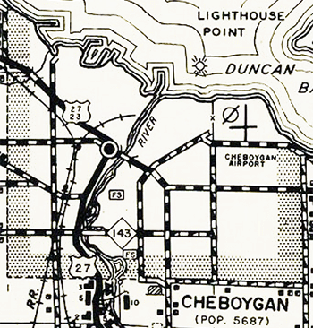
1931 (Aug 17) – A short, new state trunkline is established at Cheboygan and designated M-143 to serve as an access route from US-23/US-27 to the Cheboygan State Park on the southern edge of town. (Note: This early Cheboygan State Park should not be confused with the modern-day Cheboygan State Park east of the city off present-day US-23.) The new M-143 begins at US-23/US-27/S Main St (present-day M-27) on the south side of Cheboygan and proceeds easterly 0.9 miles via Lincoln Ave, terminating at Lafayette St. |
| |
1945 – The primary reason for the existence of M-143, the original Cheboygan State Park (present-day Cheboygan Co Fairgrounds), disappears from official maps. It seems this was the timeframe when the park was turned over to local authorities for maintenance and upkeep. However, the state trunkline created to provide access to the park would continue to exist for about 15 more years! |
| |
1960 (Jan 8) – Reality finally catches up with M-143 at Cheboygan when all 0.9 miles are cancelled and the designation is removed from the state trunkline system. Lincoln Ave is turned back to local control. |
| |
1962 (Dec 12, Dec 14) – I-96 around Lansing is officially established as a state trunkline route on December 12 and opens to traffic on December 14. With the completion of this major link in the Detroit-Muskegon freeway, the US-16 designation in Michigan is officially decommissioned, resulting in several route changes. Previously, M-43 entered Lansing from the west via Saginaw St, turned southerly with US-27/M-78 via Cedar-Larch Sts, then back easterly again via Michigan Ave into East Lansing, terminating downtown at US-16/Grand River Ave. When US-16 is removed in the Lansing/East Lansing area, it is established the M-43 designation will be extended easterly from downtown East Lansing via the former US-16 through Okemos and Williamston, terminating at I-96 near Webberville. However, this would leave a portion of the former US-16 along Grand River Ave from M-78/Saginaw St to M-43/Michigan Ave with no state trunkline designation. The route of M-43 is then adjusted to continue easterly with M-78 from US-27/Cedar–Larch Sts via Saginaw–Oakland Sts and Saginaw St–Grand River Ave to the Lansing/East Lansing limit, then southeasterly via the former US-16 along Grand River Ave into downtown East Lansing. This then leaves Michigan Ave from US-27/Cedar–Larch Sts in downtown Lansing to M-43/Grand River Ave in downtown East Lansing without a route designation. The M-143 designation is revived and applied to this route, thus signalling the debut of the third iteration of M-143. |
| |
1970 (June) – Less than eight years after becoming M-143, the Dept of State Highways first asks the City of Lansing to accept jurisdiction over Michigan Ave from US-27/Cedar-Larch Sts in downtown easterly to the East Lansing City limit. The City rejects the request and M-143 remains a state trunkline in Lansing along E Michigan Ave for the time being. |
| |
1989 (Oct 14) – All of M-143 within the City of Lansing (except the one block between nbd BL I-96/BUS US-27/Larch St and sbd BL I-96/BUS US-27/Cedar St) is cancelled as a state trunkline route and turned back to City of Lansing control (2.225 miles). This is the result of a deal between the City of Lansing and MDOT, whereby Lansing would take Michigan Ave east of Larch St off the state's hands in exchange for the state taking several streets in the downtown core off Lansing's hands, resulting in the creation of the signed Capitol Loop route. The one block of the former M-143 between Cedar & Larch Sts retained as a state trunkline is incorporated into the Capitol Loop. The East Lansing portion of the route, however, is not turned back and remains an unsigned state trunkline highway. |
| |
2013 (June) – During a massive 2012–2013 reconstruction project involving all of M-143 portion of Michigan Ave and a major portion of M-43/Grand River Ave in East Lansing, MDOT unexpectedly decides to re-erect all M-143 route signage along the East Lansing portion of Michigan Ave. Improvements include resurfacing the roadway from just west of Harrison Rd, east to the M-43 split. In addition, the intersections at Harrison Rd and Beal St are reconfigured. Why MDOT decides to sign a trunkline having a terminus at a city limit—and also falls approximately 2,100 feet shy of intersecting another state trunkline (US-127) because of that terminus—is unclear and seemingly runs contrary to some of the department's longstanding route signage practices. |
| |
2024 (Mar 26) – The Capitol Loop is cancelled as a state trunkline highway route and all portions of the route not concurrently designated with other rotues (e.g. BL I-96) are transferred to municipal control. The City of Lansing had been slowly converting some of its downtown one-way streets to two-way operation and had been in talks with MDOT to possibly regain control of the Capitol Loop streets to potentially convert those to two-way traffic as well. The Capitol Loop cancellation, interestingly, comes with a "re-establishment" of a portion of M-143 along Michigan Ave from Detroit St (one block west of US-127 at the wbd Michigan Left location) easterly to the Lansing/East Lansing city limit. This segment had been cancelled and turned back to city control in October 1989 when the Capitol Loop was established and transferred to state control! Now, the reverse has ocurred, at least in part: Michigan Ave from Detroit St just west of US-127 easterly to the Lansing/East Lansing city limit is transferred back to state control and becomes a westerly extension for the route of M-143. (The portion of the former 1962–1989 route of M-143 along Michigan Ave from downtown Lansing easterly to Detroit St is not affected and remains a city street.) |
| Controlled Access: |
No portion of M-143 is freeway or expressway. |
| NHS: |
The entire route of M-143 is on the National Highway System (NHS). (24.40 miles) |
| Memorial Highway: |
At present, no portion of M-143 has been designated as part of a Memorial Highway. |
| Photographs: |
|
| Weblinks: |
|