| Western Terminus: |
I-96 at Exit 50 south of Lowell |
| Eastern Terminus: |
US-24/Telegraph Rd on the west side of Monroe (cnr Custer Rd-Front St & Telegraph Rd) |
| Length: |
140.691 miles |
| Maps: |
Route Map of M-50 |
| Notes: |
M-50 was once a "Coast-to-Coast" trans-peninsular highway, extending from Monroe on Lake Erie to the small hamlet of Agnew near the Lake Michigan shore in Ottawa Co south of Grand Haven. In the 1964, M-50 was truncated at I-96 near Lowell east of Grand Rapids and all of the former M-50 from Grand Rapids westerly toward Lake Michigan was redesignated as M-45. |
| |
In June 1996, the route of M-50 was scaled back from I-75 northeast of Monroe to end in downtown Monroe at M-125, shortening the route by 2.66 miles. An additional 1.19 miles of M-50 in Monroe were turned back to local control in October 2006 when the portion of the route from US-24 to M-125 was turned back to local control. |
| |
As part of replacing the M-50/Alden Nash Rd overpass on I-96 south of Lowell in 2014, MDOT chose the project to be the location of one of the department's first two "bridge slides." Built in 1959 and rehabilitated in 1980, the original overpass had outived its usefulness as well as being too narrow to accommodate growing traffic volumes. Traditional overpass replacement methods would include demolishing half of the existing overpass at a time and, similarly, constructing the replacement one half at a time as well or even closing the overpass completely to remove it and then construct its replacement on the same site. Complete closure would result in a detour of up to four miles and requiring the improvement of nearby county roads to handle the additional traffic. However, MDOT chose to employ a newer technique used only a handful of times in other states, but one with proven benefits at the same time as reducing motorist inconvenience. From a Federal Highway Administration (FHWA) "Techbrief" on the topic:
"Slide-in Bridge Construction (SIBC) is a cost-effective technique in which roadway closures typically last 48 to 72 hours and may be even shorter. This technique builds a new bridge off site or on temporary supports parallel to an existing bridge, removes the old bridge, and then transports in the new bridge or, if built in parallel to the existing structure, slides the new bridge over onto the existing substructure or alignment. A growing number of State agencies have applied this method to improve safety, quality, and durability and to reduce construction and user delay costs as well as environmental impacts."
The replacement bridge was built on temporary supports from May through July 2014 and the original 1959 arched beam overpass was demolished the weekend of August 1. M-50/Alden Nash Ave traffic was shifted onto the new bridge (resting on temporary supports immediately to the west of the original overpass) beginning the first week of August while new bridge piers were constructed. The new overpass was slid into place and the whole project completed in November 2014.
Slide-In Bridge Construction Links:
• Slide-In Bridge Construction TechBrief: Exeuctive Summary – from FHWA, Spring 2014
• M-50 Bridge Replacement over I-96, Kent County – archived project site from MDOT
• Bridge Slide Demonstration Video – on YouTube |
| |
In "State Trunkline Needs, 1960–1980," a set of maps prepared by the State Highway Dept's Office of Planning, Programming Division in 1960 showing possible additions, upgrades and improvements to the state trunkline system over the ensuing twenty years, MSHD staff recommended many changes to the route of M-50 during that timeframe, including:
- Converting the existing alignment of M-50 to an unconrolled-access divided highway from the western city limit of Monroe west of Westwood Dr westerly to Lewis Ave-Ida Maybee Rd (then US-23 and proposed as part of an extended M-34 alignment). Only the portion of M-50 from west of Westwood Dr to approximately ¼ mile west of Raisinville Rd was upgraded to a divided highway, while the rest was never implemented.
- Constructing a southern bypass of the small hamlet of Ridgeway, approximately 1½ miles west of downtown Britton in Lenawee Co, with the former route through the center of the community being turned back to local control. This proposal was never implemented.
- Converting the existing alignment of M-50 to an uncontrolled-access divided highway from Adrian St on the west side of Tecumseh westerly to an interchange with the proposed M-47 freeway (never constructed) just west of Adrian Hwy. While right-of-way for the expanded highway was reserved on the north side of M-50, neither the divided highway conversion or the interchange with the M-47 freeway have ever come to pass.
- Jurisdictionally transferring all of M-50 beginning at an interchange with a proposed US-112 freeway near the intersection of M-50/Monroe Rd & Wisner Hwy five miles west of downtown Tecumseh northwesterly through Cambridge Junction and Brooklyn to the southern US-127 junction southeast of Jackson to local control. (This would have, assumedly, resulted in a different route designation for either the Monroe–Tecumseh or Jackson–Holland segment, as the MSHD would have likely not run the M-50 designation westerly along the proposed US-112 freeway, then northerly along the proposed US-127 freeway to Jackson.) This concept was never implemented and M-50 remains a state trunkline along this route today.
- Converting the existing alignment of M-50 to an uncontrolled-access divided highway from the northern jct with US-127 north of Jackson to Rives Junction Rd. This proposal was never acted upon.
- A major realignment for M-50 from the Woodbury/Lake Odessa area westerly to the Lakeshore. From the 90° turn in the existing route of M-50 from Brown Rd onto Velte Rd southeast of Lake Odessa, M-50 was proposed to continue due westerly via Brown Rd across the majority of northern Barry Co, including new alignment segments from Hammond Rd near Freeport to Wood School Rd and across the Thornapple River at the hamlet of Parmalee. Approximately ¾ mile west of Whitneyville Rd, M-50 would have angled northwesterly to a junction with M-37/Cherry Valley Rd at the 108th St intersection on the Barry/Kent Co line south of Caledonia. From there, M-50 was proposed to continue westerly via 108th St to just east of 4th St in Allegan Co where it would have angled southwesterly past the northwestern shore of Green Lake to 6th St, then followed 144th Ave westerly across Allegan Co (including a new alignment segment between 43rd and 47th Sts) to a new terminus at M-40 in the southeastern portion of Holland. (There was to be no interchange with the proposed I-96—now I-196—freeway, as it would have been within a mile of the proposed M-40 interchange.) The segments of M-50 from Velte & Brown Rds southeast of Lake Odessa to US-16/Cascade Rd south of Lowell, concurrently with US-16 from there to I-96 east of Grand Rapids, and from Division Ave in downtown Grand Rapids westerly to US-31 at Agnew in Ottawa Co were to all have been transferred to local control, while the portion from I-96 east of Grand Rapids to Division Ave in downtown Grand Rapids would have remained a state trunkline with a BUS US-16 or BL I-96 designation. The vast majority of this proposal was ever implemented, although M-50 was truncated at I-96 south of Lowell and the portion of M-50 from downtown Grand Rapids westerly was redesignated as M-45 four years later.
|
| History: |
1915 (Nov 27)  – The first section of state trunkline route on T.L. 50 (Trunk Line 50) is officially established in Monroe Co beginning at Telegraph Rd and runing westerly via North Custer Rd, then turning southerly to cross the River Raisin at Raisinville, then turning westerly again along South Custer Rd to the Dundee east city limit. – The first section of state trunkline route on T.L. 50 (Trunk Line 50) is officially established in Monroe Co beginning at Telegraph Rd and runing westerly via North Custer Rd, then turning southerly to cross the River Raisin at Raisinville, then turning westerly again along South Custer Rd to the Dundee east city limit. |
| |
1918 (Mar 28) – The next portion of T.L. 50 to be officially established is the 8.3-mile section from the Dundee west city limit in Monroe Co west-northwesterly to downtown Britton in Lenawee Co. |
| |
1919 (Sept 18) – The established route of T.L. 50 in Monroe Co is altered when the bridge spanning the River Raisin at Raisinville fails. Because of this, Ida Maybee Rd from exisitng T.L. 50 at South Custer Rd northerly across the river to North Custer Rd near Grape, and North Custer Rd from Ida Maybee Rd easterly to Raisinville Rd is officially established as a new 4.7-mile long state trunkline route for T.L. 50. The former 5.0-mile trunkline route along South Custer Rd from Ida Maybee Rd easterly to the Raisinville bridge and northerly across the river via the (former) bridge is cancelled as a state trunkline route. |
| |
1919 (Dec 31) – The 0.5-mile stretch of Tecumseh St in Dundee from the west city limit easterly to approximately Barnum St is officially established as a state trunkline route as part of T.L. 50. |
| |
1920 (Apr 15–30) – T.L. 50 is signed in the field as M-50 as all state trunkline highways in the Lower Peninsula are scheduled to be signed with route markers during the last half of April. The portions of M-50 which have not yet been officially established as state trunkline become "marked-and-maintained" segments, specifically:
- From downtown Monroe and Telegraph Rd on the west side of town,
- The 1.1-mile stretch through Dundee,
- From downtown Britton to M-52 NORTH in downtown Tecumseh,
- From M-52 SOUTH three miles west of downtown Tecumseh west-northwesterly through Tipton to M-23 (present-day US-12) at Cambridge Junction.
Thus, at this point, the route of M-50 runs from M-23 at Cambridge Junction to M-10 in downtown Monroe. |
| |
1925 (Sept 1) – Two additional segments of M-50 are officially established as trunkline routes in Lenawee Co:
- The 6.5-mile portion from downtown Britton west-northwesterly to M-52 NORTH/Evans St in downtown Techumseh. (From that point westerly to M-52 SOUTH/Adrian Hwy, the route had already been established as part of M-52 in 1915.)
- The 12.1 miles of the route from M-52 SOUTH/Adrian Hwy west-northwesterly through Tipton to M-23 (present-day US-12) at Cambridge Junction.
|
| |
1925 (mid, Dec 8) – M-50 is extended toward Jackson, although the new extension begins showing up on official highway maps by June, the first 14.5-mile section from M-23 (present-day US-12) at Cambridge Junction northerly into Jackson Co, through Brooklyn and Napoleon, to Meridian Rd in the Vandercook Lake area southeast of Jackson is officially established as a state trunkline route on December 8. M-50 is likely signed along this route as far northerly as South St, then northwesterly as a "marked-and-maintained" route along South St into Jackson where it jogs northerly along Belden Rd for two blocks, then westerly along Prospect St, northerly on Francis St, westerly again via Morrell St to Greenwood Ave where it joins M-14 for another ½ block along Morrell St, then northerly with M-14 on Blackstone St to a terminus at M-17/Main St (later US-12, present-day BL I-94/Michigan Ave) in downtown Jackson. |
| |
1926 (May 18) – An additional 0.7 mile of M-50 in Monroe is officially established as a state trunkline route from M-10/Telegraph Rd (future US-24) southeasterly via Elm Ave to approximately 600 feet west of Godfroy Ave. The remainder of M-50 into downtown Monroe remains a "marked-and-maintained" route under city jurisdiction. |
| |
1926 (June 12) – The length of M-50 is nearly doubled, growing from 65 miles (Monroe–Jackson) to over 116 miles with a northwesterly extension from Jackson through Eaton Rapids and Charlotte to M-39 (present-day M-43) west of Sunfield in northwestern Eaton Co. Much of this new extension is complete and open to traffic, although two segments are not. The new extension begins in downtown Jackson at M-17/Michigan Ave and continues northerly with M-14 as a "marked-and-maintained" route along Blackstone St, then northwesterly via Lansing Ave. At Clinton Rd, M-14 veers northeasterly toward Leslie while M-50 now follows Clinton Rd northwesterly still as a "marked-and-maintained" route to the Jackson north city limit just north of Commonwealth Ave. At that point, a 52.5-mile trunkline establishment begins (17.5 miles in Jackson Co and 35.0 miles in Eaton Co) and continues northwesterly via Clinton Rd through Tompkins to the Eaton Co line where the route turns northerly, still along Clinton Tr toward Eaton Rapids, diverting to the west along present-day Durfee Rd, then easterly via Spicerville Hwy and northerly along present-day Kyle St and then Main St through downtown Eaton Rapids, crossing a Grand River feeder canal and then Spring Brook before bending to the west and then splitting from Main St to continue northwesterly along Dexter Rd and Clinton Trl. At a point six miles northwest of downtown Eaton Rapids near Perkey Rd, the established trunkline route for M-50 continues northwesterly to bypass Charlotte along the Clinton Trl trajectory even though the roadway itself for the next 5.6 miles does not yet exist.
The signed route for M-50 turns westerly to follow a "marked-and-maintained" route into Charlotte where it enters the city via Shepherd St and Upland Ave before turning northerly with M-29 (future US-27) along Cochran Ave into downtown. There, M-29 departs northeasterly for Lansing while M-50 now continues northerly along Cochran Ave/Rd stil as a "marked-and-maintained" route until it hits the officially-established route three miles north of downtown Charlotte. M-50 turns northwesterly along Clinton Trl for nearly two miles, but then departs the officially-established route again, as Clinton Trl northwesterly from Vermontville Hwy is not yet improved and definitely not to state trunkline standards. In the interim, M-50 is routed westerly via a "marked-and-maintained" route following Vermontville Hwy into Vermontville (E Main St in the village) then turns northerly on N Main St (yes, both of Vermontville's "main" streets are named "Main St": E/W Main St and N/S Main St. No, really!) to follow Ionia Rd from there to M-39/Grand Ledge Hwy where M-50 ends. (This is actually the de facto terminus of M-50 at this point. The "official" terminus for M-50 is technically at the end of the established route at the cnr of Clinton Trl & Grand Ledge Hwy ¾ mile to the west.)
While this new M-50 extension officially measures at about 52 miles, when the temporary/"marked-and-maintained" segments are counted for, the extension comes in at over 58 miles. |
|
1926 (Nov 1) – A new 2.4-mile state trunkline is officially established leading into Jackson from the Vandercook Lake area starting at the Brooklyn Rd-McDevitt Ave & Meridian Rd intersection—at the north end of the existing established trunkline segment from the previous December—and proceeds northwesterly along the present-day route of M-50 and BUS US-127 to the Jackson south city limit where it meets the "marked-and-maintained" route of M-50 along South St. While it is now an established trunkline route, it will not be completed and opened to traffic until sometime in 1927 and, as such, the "marked-and-maintained" route of M-50 along South St remains until construction on the newly-established trunklne is complete. |
| |
1927–28 – At this point, the primary route for M-50 into Jackson from the southeast is indicated to follow South St then jogs northerly along Belden Rd for two blocks, then westerly along Prospect St, northerly on Francis St, westerly again via Morrell St, then northerly on Blackstone St into downtown. However, official maps during this period indicate a second route for M-50 traffic continuing northwesterly along Belden Rd from Prospect St to Biddle St, then westerly via Biddle for 1½ blocks, northerly again along Milwaukee St, then northwesterly following Mill St (also known as Michigan Ave before Main St was renamed as present-day Michigan Ave) to M-17/Main St (later renamed Michigan Ave, now partially obliterated downtown). How each route is signed in the field is not yet clear, however. |
|
1927 (Feb 7) – A new 23.1-mile state trunkline route is officially established in Kent and Ottawa Cos, beginning at Covell Ave on the Grand Rapids west city limit and proceeding westerly along Lake Michigan Dr through Allendale to M-11 (soon to become US-31) near the hamlet of Agnew south of Grand Haven. The new route will become part of a massive westerly extension of M-50, which currently ends in in northwestern Eaton Co (west of Sunfield), although only the portion from 68th Ave at Allendale westerly to 120th Ave is fully completed and open to traffic. |
|
1927 (May 15) – While none of the existing route of M-50 is directly affected by the debut of the U.S. Highway System, the length of the route is more than tripled when M-50 is extended northwesterly from its new north/western terminus established almost a year prior to first supplant the exisitng route of M-39 into Ionia Co, through Lake Odessa and into Kent Co to M-16-turned-US-16 south of Lowell. From there, M-50 now continues westerly with US-16 into downtown Grand Rapids where the official routing will continue via Bridge St westerly out of downtown, then along Lake Michigan Dr out of the city and into Ottawa Co, through Allendale to a new terminus at M-11-turned-US-31 near the hamlet of Agnew south of Grand Haven. However, since portions of the new route of M-50 west of Grand Rapids is not open for travel, M-50 is temporarily detoured from downtown Grand Rapids to follow the route of US-16 northerly to Leonard St, then westerly still with US-16, continuing to the west via Leonard St when US-16 veers off to the northwest toward Marne. The M-50 detour route follows Leonard St through the hamlets of Tallmadge and Lemont to 68th Ave at Eastmanville where it turns southerly via 68th to Allendale. M-50 then utilizes a completed segment of Lake Michigan Dr between Allendale and 120th Ave where a second temporary route follows 120th Ave northerly, Lincoln St westerly, 144th Ave northerly, then Mercury Dr northwesterly into Grand Haven to US-31. The new officially-established route of the extension to US-31 adds approximatley 69 miles to the route of M-50, but with the temporary routings and detours, the signed route of M-50 is now currently 80 miles longer. And while construction on the portion of Lake Michigan Dr from Covell Ave on the Grand Rapids west city limit westerly to the Kent/Ottawa Co line is completed in late 1927, M-50 traffic remains routed via the detour route until the entire roadway is completed. |
| |
1928 (June 28) – A 0.7-mile extension of the officially established route of M-50 on the south side of Jackson begins at the south city limit and continues northwesterly along Brooklyn Rd/Fargo Rd, then westerly four blocks via Prospect Ave to Francis St where the "marked-and-maintained" route continues northerly though the center of the city. (At this time, the "additional route" for M-50 noted under "1927–28" above running along Belden Rd, Biddle St, Milwaukee St, Mill St/Michigan Ave into downtown is removed from official maps.) |
| |
1928 (Aug 29, Nov 14)  – The segment of M-50 between Grand Rapids and US-31 at Agnew south of Grand Haven is officially dedicated in ceremonies held on August 29 in Allendale in central Ottawa Co, approximately halfway along the segment. Speaking at the ceremony are U.S. Senator Arthur H. Vandenberg, State Senators James C. Quinlan and V.A. Martin, and State Highway Commissioner Frank F. Rogers. The entire roadway, however, do not yet seem to be complete and open to traffic as another grand opening ceremony is held on November 14 at Grand Rapids with the usual dignitaries and fanfare. The temporary detours are removed and M-50 now runs directly from Grand Rapids westerly through Allendale to US-31. – The segment of M-50 between Grand Rapids and US-31 at Agnew south of Grand Haven is officially dedicated in ceremonies held on August 29 in Allendale in central Ottawa Co, approximately halfway along the segment. Speaking at the ceremony are U.S. Senator Arthur H. Vandenberg, State Senators James C. Quinlan and V.A. Martin, and State Highway Commissioner Frank F. Rogers. The entire roadway, however, do not yet seem to be complete and open to traffic as another grand opening ceremony is held on November 14 at Grand Rapids with the usual dignitaries and fanfare. The temporary detours are removed and M-50 now runs directly from Grand Rapids westerly through Allendale to US-31. |
| |
1928 (Sept 7) – The bridge carrying M-50/W Fulton St over the Grand River in downtown Grand Rapids is officially dedicated as the Dean Memorial Bridge, named for Private William H. Dean who, during the Spanish-American War, was the first solider to volunteer to participate in Walter Reed's yellow fever expriments which eventually resulted in the discovery of mosquitoes as being the carrier of the disease. |
| |
1928 (late) – By late 1928, the route of M-50 between US-23/Lewis Ave and the City of Monroe is transferred back to the south side of the River Raisin, running along South Custer Rd, although that portion of highway would not be officially established as a state trunkline highway route for over a decade! Thus, the segment of M-50 along South Custer Rd between US-23/Lewis Ave and Monroe becomes a "marked-and-maintained" trunkline route, while the former route of M-50 along Ida Maybee Rd and North Custer Rd is likely designated and signed as M-130 at this point. |
| |
1929 (Winter–Spring) – The signing of the new Albion-to-Lansing trunkline route as M-9 is completed with news reports noting the route being signed as such as early as February and as late as April. Thus, the seven-mile portion of M-50 from Eaton Rapids southerly into Jackson Co is now concurrently designated as M-9/M-50. |
| |
1929 (May 20) – The beginnings of a new western "bypass" of the downtown area of Jackson for US-127 and M-50 is formed when St Clair Ave (from Lansing Ave westerly to Clinton Rd and N West Ave), N West Ave (from Clinton Rd and St Clair Ave southerly to Ganson St), and S West Ave (from Glenwood Ave southerly to High St) are established as state trunkline routes. While not completely under state control, it appears this "downtown bypass" is signed as the US-127 and M-50 mainline route at this time, with M-50 now running northerly from Prospect Ave along Milwaukee St, westerly via High St to West St (with US-127 joining at Fourth St), then northerly along West St back to the former route at Clinton Rd & St Clair Ave. The former route of M-50 along Francis St, Morrill St, Blackstone St, Lansing Ave and Clinton Rd (to the St Clair Ave/High St intersection) was a "marked-and-maintained" route and simply remains under city control. |
| |
1929 (Summer) – By summer, the temporary signed route for M-50 between Charlotte and the Woodbury area is altered so that M-50 now runs due northerly from Charlotte via Cochran Rd (with the "marked-and-maintained" portion starting at the Clinton Tr intersection and continuing northerly to M-39/Grand Ledge Hwy), then westerly along M-39/Grand Ledge Hwy back its former (temporary) route at Ionia Rd west of Sunfield. The former temporary route through Vermontville via Vermontville Hwy, E Main and N Main Sts in the village and Ionia Rd were only "marked-and-maintained" segments and, therefore, simply revert to county and municipal maintenance. |
| |
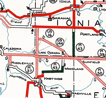 1929 (Nov 25, Dec 2) – A new 8.4-mile angling proposed state trunkline route is established in Ionia Co (6.9 miles on November 25, an additional 1.5 miles on December 2) from Lake Odessa northwesterly along the Pere Marquette Ry (later C&O, Chessie System, now CSXT Transportation) line, passing south of Clarksville, then turning westerly along Drew Rd to Hastings Rd southeast of Elmdale (Hastings Rd is proposed as a new routing for M-66 in the future at this time). This new proposed angling route is assigned the M-144 designation at this point. (The "US" 144 symbol in the map snippet at right is in error—it was obviously going to be M-144 and was shown as such on State Highway Dept Trunkline Determination Maps from that time.) 1929 (Nov 25, Dec 2) – A new 8.4-mile angling proposed state trunkline route is established in Ionia Co (6.9 miles on November 25, an additional 1.5 miles on December 2) from Lake Odessa northwesterly along the Pere Marquette Ry (later C&O, Chessie System, now CSXT Transportation) line, passing south of Clarksville, then turning westerly along Drew Rd to Hastings Rd southeast of Elmdale (Hastings Rd is proposed as a new routing for M-66 in the future at this time). This new proposed angling route is assigned the M-144 designation at this point. (The "US" 144 symbol in the map snippet at right is in error—it was obviously going to be M-144 and was shown as such on State Highway Dept Trunkline Determination Maps from that time.) |
| |
1930 (June 30) – A new approach into Grand Rapids for US-16 and M-50 is proposed to run along a new alignment from the exisitng Cascade Rd route (at a point 3 miles northwest of downtown Cascade), then due westerly along the Ada/Cascade and Grand Rapids/Paris township lines to the East Grand Rapids city limit. The newly-established but unbuilt route, along what would be an eastern extension of Hall St, is 2.6 miles long. The plan is to reroute US-16/M-50 to depart Cascade Rd at a point three miles northwest of downtown Cascade and travel westerly to the East Grand Rapids city limit, however since state trunkline routes were not officially established through the centers of cities in 1930, the eventual planned route for US-16/M-50 from this point into downtown Grand Rapids is only a matter of conjecture. The route may have continued westerly for four miles via Hall St to US-131 where it would turn northerly with US-131 into downtown, or it may have followed Hall St westerly only as far as Lake Dr, then northwesterly through East Grand Rapids and rejoining its existing route at Robinson Rd to continue into downtown Grand Rapids. Simultaneous to the new trunkline establishment, the 2.05 mile section of US-16/M-50 from the proposed route of the M-114/Grand Rapids Beltline (present-day M-37/East Beltline Ave) northwesterly along Cascade Rd then westerly via Robinson Rd to the Grand Rapids east city limit is cancelled as a state trunkline route but, as the new "Hall St" route is not yet constructed, the existing US-16/M-50 along Cascade and Robinson remains a "marked-and-maintained" trunkline route. |
| |
1930 (Dec 30–31) – Over the course of two days, the route of M-50 between Lake Odessa in southern Ionia Co and US-16 near Alto (south of Lowell) in Kent Co is cancelled as a state trunkline route. First, on December 30, the the 9.1-mile Ionia Co portion from the Kent Co line easterly along Thompson Rd, Nash Hwy and Tupper Lake Rd to just east of Tasker Rd is cancelled. Then on December 31, the 9.0-mile Kent Co portion is cancelled beginning at US-16/Cascade Rd near Alto continuing southerly along Alden Nash Ave, then easterly via 92nd St to the Ionia Co line. The M-50 designation is likely moved to the new angling trunkline from Lake Odessa northwesterly past Clarksville which was established just over a year prior, replacing its initial designation of M-144. However, as the new anglihg route is not yet built, exisitng M-50 between US-16 and Lake Odessa remains signed along its existing route as a "marked-and-maintained" trunkline route. |
| |
1931 (May 19) – Act 131 of 1931—the Dykstra Act—is passed allowing the State Highway Dept to take over control of state highways running into and through incorporated cities, thereby officially incorporating them as state trunkline highways. The following segments of formerly city-controlled street are assumed into the system along M-50:
- In Grand Rapids, the 4.7 miles through the heart of the city from Covell Ave southeasterly and easterly via Lake Michigan Dr and Fulton St, then southeasterly along Lake Dr and easterly on Robinson Rd to the Grand Rapids east city limit.
- Through Charlotte, the 1.8 miles of Cochran Ave, including the 0.8-mile segment from Lawrence Ave downtown northerly and the 1.0-mile portion concurrent with US-27 from Lawrence Ave downtown southerly to Upland Ave.
- In Jackson, the two remaining concurrent segments with US-127 totalling 1.4 miles: along West Ave from Ganson St southerly to Glenwood Ave; and along High St from West Ave easterly to Fourth St.
- Through Dundee, the 1.0-mile segment of Tecumseh & Monroe Sts from approximately Barnum St southeasterly to Dundee east city limit.
|
| |
1932 (Oct 29) – The 2.6-mile unbuilt US-16/M-50 relocation along the Ada/Cascade and Grand Rapids/Paris township line east of East Grand Rapids in Kent Co is cancelled as a trunkline route without having been constructed. The 2.1-mile marked route of US-16/M-50 along Cascade Rd from Hall St to Robinson Rd and via Robinson Rd from Cascade Rd westerly to the Grand Rapids east city limit is re-established as a state trunkline route 28 month after being cancelled. Additionally, a 0.2-mile trunkline route is established from the west end of Cascade Rd at Robinson Rd north of East Grand Rapids northwesterly to M-21/Fulton St (to become a new route for US-16/M-50 in the future), but as this segment has not yet been constructed, US-16 and M-50 remain signed along Robinson Rd and Lake Dr for now. |
| |
1932 (Oct 29) – A pair of additional changes are made to the route of M-50 also occur:
- The 2.2-mile section of Cochran Rd in Eaton Co from Charlotte northerly to the Clinton Trl turnoff—part of the "temporary" marked-and-maintained route of M-50 pending the completion of the established Charlotte "bypass route"—is established as a state trunkline route. (Although the unbuilt bypass route remains an established route and the four-mile "temporary route" east of Charlotte also remains a "marked-and-maintained" but not yet officially established route.)
- In mid-1928, Prospect St on the south side of Jackson from Belden Rd/Brooklyn Rd westerly to Francis St was officially established as part of the route of M-50 through the city, although only the portion from Belden/Brooklyn westerly to Milwaukee St was signed as part of M-50 (the route turns northerly on Milwaukee St to High St). As such, the "additional" block (0.2 mile) of Prospect St from Milwaukee to Francis is cancelled as part of the trunkline route. (The portion of M-50 along Milwaukee St from Prospect to High and via High St from Milwaukee to Fourth St remains a "marked-and-maintained" trunkline under city jurisidiction.
|
| |
1934 (Aug 3) – In Monroe, the 0.838-mile section of Front St from US-24/Telegraph Rd southeasterly into the downtown area to the intersection with First St is officially established as a state trunkline route, although it has been signed as part of M-50 for several years at this point. |
| |
1934 – While the Clinton Trl segment of M-50 from north of Charlotte northwesterly to M-39/Grand Ledge Hwy west of Sunfield has been the highway's established route since 1926, it has taken eight years for the existing roadway to be upgraded to state highway standards. For the previous five years, M-50 has been signed along Cochran Rd northerly from Charlotte for 13 miles as a "marked-and-maintained" (not officially established) route to M-39 between Grand Ledge and Mulliken, then westerly along M-39 past Sunfield to Clinton Trl southeast of Woodbury. With the completion of M-50 along Clinton Trl from Cochran Rd northwesterly to M-39 (present-day M-43), the former signed route along Cochran Rd reverts to county maintenance while the jointly-signed M-39 stretch remains part of M-39. While the officially established mileage for M-50 does not change, the signed route is now 6.1 miles shorter. (The 5.6 mile established-but-yet-to-be-constructed "Charlotte bypass" section of M-50 remains the officially-established route and, as of 1930, had been anticipated to be completed by 1935.) |
| |
1934 (Summer, Nov 5) – After being initially denied by the U.S. Bureau of Public Roads, the agency approves rerouting M-50 in the southern part of Jackson to run westerly along Prospect Ave from Milwaukee St westerly to US-127/Fourth St, then turn northerly with US-127 along Fourth St to the existing route at High St, where both US-127 and M-50 now turn westerly along High St before heading northerly together along West St. (The BPR initially objects to M-50 being routed along Prospect Ave due to the Michigan Air Line Railroad grade crossing but relents after the State Highway Dept reassures the BPR only a few trains a day run along that line.) The change is made during the Summer, while the nine blocks (0.754 mile) of Prospect Ave from Francis St westerly to US-127/Fourth St is officially certified as a trunkline route on November 5. Oddly, though, the one block (0.2 mile) of Prospect between Milwaukee St and Francis St—which was cancelled as a trunkline route in October 1932—is not re-established, meaning there is a one-block gap in the officially-established route of M-50 across the south side of Jackson. The former route of M-50 along Milwaukee St and High St remains under city jurisidiction. |
| |
1934 (Nov 14) – A new 1.128-mile alignment for M-50 on the southeast side of Lake Odessa in southern Ionia Co is officially established and likely opens to traffic at this point. The new alignment departs the Haddix Rd (the existing route) just north of the Barry/Ionia Co line and continues northwesterly along the south side of the Pere Marquette Ry line into Lake Odessa to Maier Dr. This is one phase of a project to continue the new angling alignment of M-50 southeasterly from Haddix Rd into Barry Co where it would merge back into the exisitng route of M-50 along Brown Rd, just west of the M-14 junction (present-day M-66) on the Barry/Eaton Co line—which would never end up being constructed. The former route of M-50 along Haddix Rd northerly and Huddle Rd westerly is cancelled as a state trunkline route and turned back to county control either at this point or some time in 1935 (currently available records on this are not clear). |
| |
1935 (Aug 15) – As part of a highway widening project along Cascade Rd from Forest Hill Ave northwesterly to Robinson Rd near East Grand Rapids in Kent Co, a new 0.2-mile extension of Cascade Rd from Robinson Rd northwesterly to M-21/Fulton St—which had been established in late 1932—is completed and opened to traffic. Now US-16/M-50 continues northwesterly on the new segment of Cascade Rd from Robinson Rd to M-21/Fulton St, then westerly with M-21 along Fulton St into Grand Rapids. The former route of US-16/M-50 via Robinson Rd and Lake Dr is retained as an unsigned trunkline route for the time being, however. |
| |
1935 (Oct 22) – The proposed but never constructed direct angling trunkline from Lake Odessa northwesterly past Clarksville to a proposed southerly extension of M-66 along Hastings Rd in southwest Ionia Co (originally established as M-144 in 1929) is cancelled and 8.4-mile route will go unbuilt. The 18.1-mile existing, signed route of M-50 from US-16 near Alto in Kent Co southerly along Alden Nash Rd, easterly via 92nd St and Thompson Rd, southerly on Nash Hwy, and easterly again via Tupper Lake Rd into Lake Odessa is re-established as a trunkline route. So, to the motoring public, nothing has actually changed along the route over the preceeding six years, as M-50 markers had always remained along the 18.1-mile route from Lake Odessa to US-16. (The proposed but never-built M-39 extension westerly across northernmost Barry Co and southernmost Kent Co to M-37 south of Caledonia is also officially cancelled as a trunkline route at the same time.)
Additionally, a new 1.1-mile route for M-50 through Lake Odessa is established beginning at Tupper Lake St and continuing southerly along Fourth Ave, then easterly via Jordan Lake St to the Huddle Rd connector and the new M-50 alignment from the southeast from late 1934. The former 1.0 mile route via Tupper Lake St, southerly along Jordan Lake Ave, then southeasterly on Second St–Huddle Rd is cancelled as a trunkline route and turned back to local control. |
| |
1937 (Aug 30) – The one block of Prospect Ave in the southern part of Jackson from Milwaukee St to Francis St, signed as part of M-50 for three years at this point and, ironically, cancelled as a state trunkline route in late 1932, is re-established as a trunkline and fills a gap in the established route. |
| |
1937 (Aug 30, Sept 27) – The unsigned former route of US-16/M-50 along Robinson Rd and Lake Dr in the East Grand Rapids and Grand Rapids area, which had been bypassed by the new Cascade Rd connector two years prior, is cancelled as a state trunkline in two pieces. First, on August 30, the 1.4-mile portion of Robinson Rd from US-16/M-50/Cascade Rd southwesterly to the Grand Rapids east city limit (just east of Woodmere Rd) is cancelled and turned back to county control. Then, a month later on September 27, the 1.1-mile segment of Robinson Rd from the city limit westerly to Lake Dr and Lake Dr from Robinson Rd northwesterly to M-21/M-37/Eastern Ave is similarly cancelled and turned back to city control. (The 0.3-mile section of Lake Dr from Eastern Ave northwesterly to US-16/M-50/Fulton St is retained as a trunkline as it is part of the M-37 route into downtown Grand Rapids.) |
| |
1939 (July 13) – Even though it has been signed as part of M-50 and unambiguously depicted on official highway maps as such since late 1928, the 7.4-mile segment of M-50 along South Custer Rd from US-23/Ida-Maybee Rd southeasterly to US-24/Telegraph Rd on the west edge of Monroe is (finally) officially re-established as a state trunkline route. It had been merely "marked-and-maintained" as M-50 for over a decade. (The portion of Front St—the continuation of South Custer Rd into Monroe—from US-24/Telegraph Rd into downtown Monroe had been officially established in August 1934.) |
| |
1939 (July 13) – A new 1.2-mile alignment for M-9/M-50 entering Eaton Rapids from the south is officially established as a trunkline route, beginning at present-day Durfee Rd and continuing northerly and northeasterly, merging back into the existing alignment north of Spicerville Hwy–Kinneville Rd. The existing 1.7-mile route along present-day Durfee Rd, Spicerville Hwy and Kyle Ave remains "marked-and-maintained" as M-9/M-50 until the new alignment is completed and opened to traffic. |
| |
1940 (April/May) – M-9 becomes M-99 in its entirety and the concurrent stretch of M-9/M-50 south of Eaton Rapids now becomes M-50/M-99. |
|
1940 (July 13) – In a project started while the route was still designated M-9, the reconstruction and realignment of M-99 between Eaton Rapids and Springport—which includes the portion of M-50 from Eaton Rapids to the Eaton/Jackson Co line—is completed and opened to traffic at a ribbon cutting ceremony attended by Gov Luren Dickinson and State Highway Commissioner Murray D Van Wagoner on the southern limits of Eaton Rapids. The new alignment had been officially established as a trunkline route in mid-July 1939, with the 1.7-mile former route along Durfee Rd, Spicerville Hwy and Kyle Ave retained as a "marked-and-maintained" route until the new route was completed. |
|
1940 (Nov 12) – A 0.6-mile section of M-50 containing a sharp turn in Sec.1 of Springport Twp in northwestern Jackson Co is cancelled as a trunkline route, replaced by newly-established 0.575-mile sweeping curve. The old route is abandoned as a public roadway and largely obliterated. The new curve is likely completed and opened to traffic during 1941. Just to the west, 1.219-mile segment of highway is officially established for M-50 consisting of a gentle, sweeping curve which actually ends 0.194 mile into Eaton Co is constructed to replace the former 1.0-mile segment following (Jackson Co's) Griffith Rd (not to be confused by nearby Griffith Rd in Eaton Co) is largely abandoned as a public roadway and reverts back to nature. |
|
1940 (Nov 12) – On the same day, another change comes to the route of M-50 in central Eaton Co, although the change comes on paper only with no publicly-detectable changes in the field. The State Highway Dept throws in the towel on building the proposed Charlotte "bypass" route connecting the two angling Clinton Trl segments southeast and northwest of the city. The "bypass" was part of the established route of M-50 through most of Eaton Co from July 1926, but was never constructed. While the 2.2-mile portion of M-50 along Cochran Rd north of Charlotte to Clinton Trl had been officially established as a trunkline eight years prior, the 4.0-mile segment of Upland Ave and Clinton Trl from US-27/Cochran Ave in Charlotte easterly to Perkey Rd has only been a "marked-and-maintained" route and not officially established or transferred to the State. With the bypass cancellation, the 4.0-mile east-west segment of Clinton Trl is officially established as a trunkline route. |
| |
1951 (Dec) – The portion of US-127/M-50 along N West Ave in Jackson from Michigan Ave northerly is concurrently designated with US-12 with the completion of the "new Jackson bypass," an east-west highway beginning east of Jackson and heading westerly north of the city, ending at US-127/M-50 northwest of downtown. |
| |
1952 (Nov 25) – With the westerly extension of the US-12 "Jackson Belt Line" from US-127/M-50 at Jackson westerly to Parma, the concurrent US-12 designation along US-127/M-50 on West St and Clinton Rd in Jackson is removed, replaced with a concurrent BUS US-12 routing along US-127/M-50. |
| |
1953 (Summer) – M-50, along with US-16 and M-21, are rerouted to bypass Grand Rapids on the south (via 28th St or "South Beltline") and west (via Wilson Ave or "West Beltline"). The former route of M-50 through Grand Rapids (Cascade Rd–Fulton St–Lake Michigan Dr) becomes is given the BUS M-50 route designation. |
|
1955 (Aug 3) – A new 1.2-mile long route for M-50 on the west side of Lake Odessa in southern Ionia Co is officially established as a trunkline route consisting of a set of sweeping curves departing the existing Tupper Lake Rd route west of Tasker Rd curving southeasterly then easterly to merge into Jordan Lake St on the western limits of Lake Odessa. The former route along Tupper Lake Rd easterly into Lake Odessa, then southerly through downtown on Fourth St to Jordan Lake St is cancelled as a trunkline route, but kept as a "marked-and-maintained" route until the new alignment is completed and opened to traffic. Grading on the new route is completed by October and is hard-surfaced during the 1956 construction season. |
| |
1955 – The final few miles of gravel-surfaced M-50 are paved, in northwest Eaton Co. |
| |
1955 (Nov 18) – An entirely new alignment for US-127 from jct US-112 & US-223 in northwesternmost Lenawee Co northerly into Jackson Co to M-50 southeast of Jackson near Vandercook Lake is officially established as a state trunkline route, running generally along the line of existing Meridian Rd, but immediately west of that road. From the jct with M-50, US-127 now runs concurrently with M-50 into Jackson via Brooklyn Rd & Prospect St, lengthening the US-127/M-50 concurrency by 3.9 miles. |
|
1956 (Mar 26) – Two sharper turns on M-50 southeast of Lake Odessa are replaced by gentler curves, with work completed in 1955. The new alignments—0.613 mile of new roadway curving from Lapo Rd in Ionia Co onto Velte Rd in Barry Co and 0.503 mile of new roadway curving from Velte Rd onto Brown Rd—are officially established and, simultaneously, the former routes, consiting of 0.64 mile along Velte–Haddix Rd then northwesterly along the south side of the C&O tracks which is eventually abandoned as a public roadway, as well as 0.6 mile of bypassed Velte Rd and Brown Rd, are cancelled as trunkline routes and turned back to county control. |
| |
1957 (Dec 18–30) – The 13.8-mile four-lane, divided US-127 expressway is completed and opened to traffic at 1:00pm on December 18 from the US-12 "Jackson North Belt" freeway northerly into Ingham Co. The project, which cost $5,284,000 to construct, completes the four-lane highway between Lansing and Jackson. The new expressway sits atop the first ¼ mile of the former route of M-50 from the US-12 freeway interchange northerly to Gilbert's Steakhouse. It also severs a 0.41-mile section of M-50 on either side of the Parnall Rd interchange. As such, M-50 is routed concurrently with US-127 between the US-12 interchange and a new partial interchange for Clinton Rd 1¾ to the north. The 1.4-mile section of former M-50 from the US-12 interchange northerly to the new Clinton Rd interchange on US-127 is cancelled as a trunkline on December 30 and the portions not obliterated or subsumed under the new US-127 are turned back to local control. (The remainder of former M-50 to the west of the US-127/M-50 expressway is renamed Clinton Way, while the segment to the east is renamed Shirley Dr.) |
| |
1959 (July 8) – For some reason, the last two blocks of the route of M-50 in downtown Monroe were never officially established as a state trunkline highway route until now. The 0.15-mile section of First St from Front St southeasterly to US-25/Monroe St is established as the eastbound route of M-50, while the 0.16-mile portion of Front St from US-25/Monroe St westerly to First St is established as the westbound side of the route. |
| |
1959 (Nov 6, Nov 21) – An 5.65-mile long eastern freeway bypass of Jackson from the jct of US-127 & M-50 southeast of Jackson northerly to I-94/US-12 northeast of Jackson is opened to traffic on November 6 and officially established as state trunkline route two weeks later on November 21. The US-127 designation is routed northerly via the new freeway to I-94/US-12, then westerly concurrently with I-94/US-12 to the jct of I-94/US-12 & US-127/M-50 northwest of Jackson. The former route of US-127/M-50 through Jackson is redesignated as M-50/BUS US-127. Sources point to the State Highway Dept initially assuming the M-50 designation would accompany US-127 bypassing Jackson with the portion of the route through the city (concurrent with BUS US-127) would be redesignated as BUS M-50. However, by the time the highway segments open to traffic, the decision has been made for M-50 to remain on its through-town route, likely to limit the number of concurrent designations, as there would be four on the "Jackson North Belt" alone: I-94/US-12/US-127/M-50! |
| |
1959 (Nov 13) – The US-16 freeway is extended westerly from Hastings Rd in western Ionia Co into Kent Co, to a temporary ending at Whitneyville Ave southeast of Cascade. From the Alden Nash Ave interchange westerly to Whitneyville Rd, M-50 is relocated onto the new freeway as well. The former route of US-16/M-50 along Cascade Rd between Alden Nash and Whitneyville remains an unsigned trunkline for the time being, while the 0.419-mile segment of Alden Nash Ave from the new US-16 freeway to former US-16 at Cascade Rd becomes part of the extended route of M-91. |
| |
1959 (Dec 10) – The entire 18-mile US-23 freeway from Sylvania, Ohio northerly to M-50 at Dundee is completed and opens to traffic. The former route of US-23 along Lewis Ave from the Ohio state line to M-50 is cancelled as a state trunkline route and turned back to county control, while the concurrent US-23/M-50 stretch westerly from Lewis Ave into Dundee retains the M-50 designation. |
| |
1960 (Aug 23) – The 5.3-mile segment of former US-16/M-50 along Cascade Rd from M-91/Alden Nash Ave (formerly part of M-50) westerly to Whitneyville Ave, the temporary connector between the new I-96/US-16/M-50 freeway and the existing route along Cascade Rd, is cancelled as a state trunkline route about nine months after the freeway segment opens to traffic (and the US-16/M-50 signs are removed from the former route). |
| |
1961 (Aug 30) – An additional eight miles of I-96/US-16/M-50 freeway are completed beginning at the temporary connector at Whitneyville Ave southeast of Cascade in central Kent Co and continuing northwesterly toward Grand Rapids. The first four miles of the new freeway from the former Whitneyville Ave connector (which is removed) to the former route of US-16/M-50 on 28th St west of Cascade is designated as part of I-96/US-16/M-50. The remaining three miles from 28th St northwesterly to Cascade Rd is designated as BUS US-16/BUS M-50, a designation which had formerly run along Cascade Rd from 28th St in Cascade northwesterly toward Grand Rapids. Until the remainder of the Detroit–Muskegon Frwy (I-96/US-16 and I-196/US-16) around Grand Rapids is completed, through US-16 and M-50 traffic will contiue to be directed around Grand Rapids via the "South Beltline" (28th St) and "West Beltline" (Wilson Ave), although the future route number for this route has already been chosen for when the freeway is complete: M-11. The former route of US-16/M-50 along Cascade Rd between Whitneyville Rd and 28th St and along 28th St from Cascade Rd to the new freeway as well as the former BUS US-16/BUS M-50 following Cascade Rd from 28th St to the new freeway (at present-day Exit 39) both temporarily remain as unsigned state trunklines. |
| |
1961 (Nov 21) – A seven-mile segment of future I-96/US-16 and future I-196/US-16 freeway is completed and opened to traffic on the northeast side of Greater Grand Rapids. Beginning at BUS US-131/Plainfield Ave (present-day Exit 33), the future I-196/US-16 continues easterly then southerly for four miles to the proposed location of the I-96/M-21 freeway interchange as it connects into downtown Grand Rapids. From that location—just west of the US-131/East Beltline Ave interchange (present-day Exit 38)—southeasterly to the end of the existing freeway at Cascade Rd, the new freeway will be signed as I-96/US-16. (At this time, I-96 is planned to head westerly through downtown Grand Rapids, then southwesterly to Holland and south to Benton Harbor. I-196, on the other hand, is the spur route from Grand Rapids northwesterly to Muskegon.) US-16 and M-50 remain signed along the south and west sides of the "Grand Rapids Beltline" system, though, until the entire section of the "Detroit-Muskegon Expressway" around Grand Rapids is complete and open to traffic. The route of BUS US-16 through downtown Grand Rapids is left intact from the new I-96/US-16 freeway (at present-day Exit 40A-B) westerly and northwesterly through Grand Rapids to Walker. This segment of freeway cost $7.5 million to construct and initially opens to "local traffic only" until the westerly extension of the freeway across the Grand River is completed and opened to traffic in one month. |
| |
1961 (Dec 22) – A pair of major developments for the route of M-50 in the Grand Rapids area:
- First, the portion of the "Detroit-Muskegon Expressway," designated as I-196/US-16 from Muskegon to the east side of Grand Rapids and as I-96/US-16 from there past Lansing to Farmington, is officially established as a state trunkline highway route throughout the entirety of Kent Co, even though portions had been completed and open to traffic in 1959 and earlier in 1961. With the official establishment of the 30.422-mile freeway segment from the Ottawa Co line to the Ionia Co line, two former trunkline routes are also cancelled and turned back to local control:
- The 6.6-mile portion of Cascade Rd in Kent Co from Whitneyville Ave northwesterly through Cascade to the new I-96/US-16/M-50 freeway (at present-day Exit 40) which had been part of BUS US-16/BUS M-50 from the freeway to 28th St and as US-16/M-50 from 28th St to Whitneyville Ave until one month prior (when those designations were transferred to the newly-opened stretch of freeway between 28th St and Cascade Rd) is cancelled as a state trunkline route and turned back to county control. It had been an unsigned trunkline for the previous month.
- The 1.8-mile section of 28th St from Cascade Rd in Cascade westerly to the I-96/US-16/M-50 freeway (at present-day Exit 43A-B), which had been signed as US-16/M-50 until November 21, is also cancelled as a state trunkline route and turned back to county control. It had also been an unsigned trunkline for the previous month.
- A 9½-mile stretch of new I-196/US-16 freeway (present-day I-96) is completed from the eastern end of the existing freeway segment at Marne, through the north side of Walker Twp, across the Grand River and into Grand Rapids to the western end of the existing freeway segment at BUS US-131/Plainfield Ave. This fills the final gap in the overall Muskegon–Lansing freeway. The former route of US-16 from present-day Exit 24 near Marne southerly to Grandville and easterly through Wyoming to the new I-96/US-16 freeway (at present-day Exit 43) is redesignated as M-11. The new freeway is signed as I-196/US-16 from Marne to present-day Mile 37 where it becomes I-96/US-16 to Cascade Rd, where the M-50 route joins the route as it heads easterly away from the Grand Rapids area. The 11-mile freeway cost $9.4 million to construct and opens one year ahead of schedule, in part because of the State Highway Dept's coordination with the contractor constructing the massive US-131 freeway interchange just west of the Grand River. The Dept requested the contractor complete the east-west portion of the interchange to allow Lansing-to-Muskegon through traffic to use the completed freeway early.
|
| |
1962 (Dec 12) – The final 54½ miles of I-96 freeway from immediately east of M-100 north of Grand Ledge easterly past Lansing and Howell to the Lake Chemung area are completed and opened to traffic. Simultaneously, all of US-16 in the state is "decommissioned" and all US-16 route markers are taken down, ending a 36-year run for the US-16 route designation in Michigan. As such, the segment of I-96/US-16/M-50 freeway between present-day exit 40 east of East Grand Rapids and present-day Exit 52 south of Lowell becomes just I-96/M-50. |
| |
1964 (Sept 9) – The City of Jackson, in a desperate effort to stem the tide of businesses and shoppers leaving the central business district, comes to an agreement with the State Highway Dept to close Michigan Ave through the central business district and, initially, reroute traffic along existing streets to form a one-way loop around the downtown area, which allows the city to establish a two-block downtown pedestrian "mall." As that happens, planning will continue on converting additional blocks of Michigan Ave and reconfiguring streets downtown to allow for a smoother traffic flow, including building new "connector" streets to shuttle traffic away from and back onto Michigan Ave from the parallel, one-way streets. During the initial trial period, no trunkline establishments or cancellations or transfers of jurisdiction occur, however eastbound BL I-94 traffic now turns southerly from Michigan Ave via Blackstone St for two blocks, then follows Washington Ave easterly three blocks and back northerly via Francis St for two blocks back to Michigan Ave, while westbound BL I-94 traffic continues west from Francis along Michigan for one block (which becomes one-way westbound only) to Mechanic St, then northerly via Mechanic St for one block, westerly along Pearl St for two blocks, and southerly on Blackstone St back to Michigan Ave. The new route becomes a "marked-and-maintained" route until a permanent "downtown perimeter traffic route" is finalized and constructed. While neither BUS US-127 nor M-50 travel through downtown yet, planning is underway to construct a new roadway for those routes to enter downtown from the southeast as well, so these changes will have a direct impact on those trunkline routes in the near future. |
| |
1964 (Nov 25, Dec 14) – State highway officials announce the truncation of M-50 at I-96 (at present-day Exit 52) south of Lowell in eastern Kent Co on November 25. The concurrent segment of I-96/M-50 from that location westerly toward Grand Rapids to Cascade Rd (at present-day Exit 40) becomes just I-96, while all of M-50 from there westerly through Grand Rapids, Standale, and Allendale to US-31 at Agnew is redesignated as M-45. The changes become official with all signage changes made on December 14. |
| |
1966 – Although 95 percent of M-56 was decommissioned in 1957, the two-mile segment between US-25 and I-75 in Monroe was, for some reason, retained. At this time, the M-56 designation is officially retired and M-50 is extended along that routing easterly from US-25 in downtown Monroe to end at I-75 at Exit 15. |
| |
1966 (Nov 14) – A ¼-mile segment of new four-lane roadway in downtown Jackson is completed and opened to traffic immediately south of and paralleling the New York Central Railroad from Michigan Ave northwesterly to just west of Mechanic St where it turns westerly, merging into an existing segment of Clinton St, which has been reconstructed into a three-lane one-way street westerly to Blackstone St. This new roadway becomes the first portion of the permanent "downtown perimeter route" to be completed and westbound BL I-94 traffic uses it to bypass much of the downtown area, turning southerly via Blackstone for two blocks back to the existing route at Michigan Ave. Eastbound BL I-94 continues to use the Blackstone–Washington–Francis "temporary" perimeter route. As with the 1964 changes, BUS US-127 and M-50 are not yet signed along the route pending completion of construction on the new Airline Rd (present-day S Cooper St) is completed. |
| |
1967 (July 28) – The easternmost portion of the permanent downtown Jackson "perimeter route" is completed and opened to traffic, with eastbound BL I-94 traffic now continuing easterly along Washington Ave from Francis St to Milwaukee St, where BL I-94 now turns northerly back to the existing route along Michigan Ave where traffic can either turn right to continue via BL I-94 along E Michigan Ave, turn left to follow westbound BL I-94 around the perimeter route, or continue straight ahead on northbound M-106. |
| |
1967 (Nov 30) – While much of the new alignment for the new BUS US-127/M-50 approach into downtown Jackson from the southeast was complete the previous year and at least some of the roadway was opened to local traffic on August 15, 1966, media reports note the State Highway Dept refrains from directing trunkline traffic along the new roadway, which is named Airline Dr (present-day S Cooper St), until all connections have been completed with the downtown Jackson "perimeter route" are completed. On November 30, the new Airline Dr route from Prospect Ave northwesterly into downtown tto the cnr of Milwaukee St & Wilkins St where it turns northerly via Milwaukee to BL I-94/Washington St. There, BUS US-127/M-50 now utilizes the downtown "perimeter route" along Louis Glick Hwy, Blackstone St, and Washington Ave, then continues westerly with BL I-94 via W Michigan Ave to the existing route of BUS US-127/M-50 at West St, where the two routes continue northerly out of the city. The former route of BUS US-127/M-50 westerly from Airline Rd via Prospect Ave, northerly on Fourth St, westerly along High St and northerly on West St to BL I-94/W Michigan Ave remains an unsigned state trunkline highway for now.
Additionally, the portions of roadway which now make up the downtown Jackson "perimeter route" are officially established as state trunkline routes, having been "marked-and-maintained" routes to this point. Specifically, the segments include Blackstone St from Clinton St/Louis Glick Hwy southerly to Washington Ave, Washington Ave from Blackstone St easterly to Milwaukee St, Milwaukee St from Washington Ave to E Michigan Ave and Louis Glick Hwy/Clinton St from Milwaukee St westerly to Blackstone St. For now, the bypassed portion of Michigan Ave through the downtown core remains an unmarked trunkline route, even though parts of it have already been closed and converted into a pedestrian mall. |
| |
1968 (Nov 1) – The portion of Michigan Ave in downtown Jackson bypassed by the preliminary downtown "perimeter route" in 1964 from Blackstone St easterly through the central business district to the newly-completed Louis Glick Hwy is cancelled as a state trunkline route and turned back to city control. Portions of this section have been converted into a pedestrian mall over the preceeding four years while other segments are obliterated and abandoned as public roadways. |
| |
1969 (Nov 2–3) – The ribbon is cut on November 2 on the completion of the BL I-94/BUS US-127/M-50 downtown Jackson "perimeter route" constructed to allow for conversion of several blocks of Michigan Ave to a pedestrian mall. A new three-lane, diagonal roadway from Louis Glick Hwy at Blackstone southwesterly to W Michigan Ave at Steward Ave is completed and opened for westbound BL I-94/M-50 and northbound BUS US-127 traffic, while a similar three-lane diagonal roadway departs from W Michigan Ave at Steward Ave continuing southeasterly, merging into Washington Ave east of First St is completed and opened for eastbound BL I-94/M-50 and southbound BUS US-127 traffic. The two new diagonal connectors are then officially established as state trunkline routes the next day on November 3: 0.328 mile for the Washington connector and 0.318 mile for the Louis Glick extension. The four block long, 0.258-mile former route along Blackstone St for eastbound/southbound traffic (W Michigan Ave to Washington Ave) and westbound/northbound traffic (Louis Glick Hwy to W Michigan Ave) as well as the three blocks (0.282 mile) section of W Michigan Ave from Blackstone St westerly to the new connectors are retained as unsigned state trunklines for the time being. |
| |
1971 (June 30) – Several former state trunklines in the City of Jackson are turned back to local control on this date. Downtown, the portions of Michigan Ave (from Second St to Blackstone St) and Blackstone St (Washington Ave to Louis Glick Hwy) superseded by the new alignments opened in November 1969 are officially cancelled and transferred to city control. The Prospect-Fourth-High-West route formerly used by BUS US-127/M-50 until late 1967 is also cancelled and transferred to city control. The signed routes of BL I-94/BUS US-127/M-50 remain unchanged. |
| |
1996 (June 28) – Noted as being "a factor in the long-range Monroe area trunkline study for many years," the 2.5-mile portion of M-50 in Monroe from downtown easterly to the route's eastern terminus at I-75/Seaway Frwy is cancelled as a state trunkline route and transferred to local control. In terms of the timing, MDOT notes, "The accelerated schedule is due to the wishes of both the city and county to take ownership control prior to the two-year construction of I-75 in northern Ohio." The 2.20-mile segment of M-50 from M-125/Monroe St southeasterly to Dixie Hwy, then northeasterly along Dixie Hwy to the east city limit is transfered to city control, while the remaining 0.30-mile segment from the east city limit through the I-75/Seaway Frwy interchange is turned over to county control. Interestingly, this truncation of M-50 returns it to the eastern terminus it had from 1915–1966. |
| |
2006 (Oct 4) – An additional 1.17 miles on the eastern end of M-50 is cancelled and turned back to city control in Monroe between M-125/Monroe Ave and US-24/Telegraph Rd west of downtown. M-50's new eastern terminus is now at US-24/Telegraph Rd. |
| |
2018 (Feb 6–Mar 26) – After being under construction for the majority of 2017, the reconfiguration of Jackson's "downtown trunkline loop" from a system of one-way thoroughfares back into two-way streets is completed and the actual traffic changes occur on February 6. The former eastbound leg of BL I-94/BUS US-127/M-50 bypassing the central business district to the south is reconfigured as a two-way street with the trunkline designations removed. Complimenting this, the westbound trunkline traffic is transferred onto Louis Glick Hwy which is similarly reconfigured to handle two-way traffic. Now, BUS US-127/M-50 enters downtown Jackson along S Cooper St (formerly Airline Hwy) and proceeds to E Michigan Ave–Louis Glick Hwy, then heads westerly bypassing downtown to the north concurrently with BL I-94 back to W Michigan Ave west of downtown where it continues via is existing route. The former eastbound side of the loop—now named Steward Ave between W Michigan Ave and First St, then as Washington Ave from First to Cooper—temporarily becomes an unsigned state trunkline, which is then cancelled and turned back to city control on March 26. The overall downtown trunkline loop conversion project, which has its roots back to February 2002 when the city recommended the changes, reverses some of the major changes made during the 1960s urban renewal efforts downtown. |
| Controlled Access: |
Two segments of M-50 exist as freeway:
- A very short segment concurrently with US-127 on the southeast side of Jackson. (0.4 mile)
- An approximately 1½-mile segment concurrently with US-127 north of Jackson. (1.6 miles)
|
| NHS: |
Two segments of M-50 are on the National Highway System (NHS):
- From the southern jct with US-127 southeast of Jackson to the northern jct with US-127 north of Jackson. (8.5 miles)
- In the City of Charlotte from I-69 at Exit 60 to the northern jct with BL I-69 downtown. (1.7 miles) (This segment was added in 2012 with the passage of the MAP-21 funding and authorization bill.)
|
| Memorial Highways: |
The following Memorial Highway designations have been officially assigned to parts of M-50 by the Michigan Legislature:
- Officer James Bonneau Memorial Bridge – "The bridge on West Avenue in Jackson County between Ganson Street and Wildwood Avenue..." From MDOT: "Police Officer James Bonneau was shot and killed after responding to a domestic disturbance. Officer Bonneau and an officer from the Blackman Township Department of Public Safety were following up on a report from earlier in the night of a domestic incident. When they arrived, the suspect opened fire, killing Officer Bonneau and wounding the Blackman Township officer. The suspect was shot and killed by the officers. Officer Bonneau had served with the Jackson Police Department for two years. He is survived by his fiancée, parents, sister, and brother."
- Ensign Francis Flaherty Memorial Highway – "The portion of highway M-50 in Eaton County beginning at the intersection of highway M-50 and highway I-69 and extending west to the intersection of highway M-50 and Courthouse Drive..."
|
| Photographs: |
|
| Weblinks: |
|