

| Back to Previous Route: Former M-145 |
 |
On to Next Route: Former M-147 |
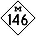
| M-146 is a former state trunkline route existing from (c.)August 31, 1931 until (c)October 15, 1964.** | |
| Southern Terminus*: | |
| Northern Terminus*: | |
| Final Length*: | |
| Maps: | |
| Notes: | * The termini and final length of M-146 reflect the beginning and ending of the route and its length as of the time of its decommissioning in 1964. |
While the portion of 24th St along the western limits of Port Huron, specificially the Dove St-to-Lapeer Ave segment, was established as a state trunkline route in 1924, that portion was apparently either an unsigned highway route or was incorporated into the route(s) of other state highway route(s). A 5.7-mile northerly extension of the proposed western bypass continuing northerly from 24th St at Lapeer Ave to the corner of 24th Ave & M-27/Pine Grove Ave, then northerly along 24th Ave to M-29/Lakeshore Rd approximately six miles north of downtown Port Huron was added in early 1930 to make the route a true bypass. US-25 was extended north from Port Huron along the Lake Huron shore to a new terminus at Port Austin at the tip of the Thumb in 1934, meaning the Port Huron West Belt would be a bypass for US-25 traffic from southwest of the city to north of the city (when completely constructed). It was also 1934 when the M-146 designation first showed up on official state highway maps distributed to the public on the existing portion of the route from US-25 in southern Port Huron to M-21/Lapeer Ave. 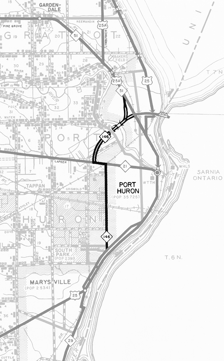 Then, in 1950, a new four lane, divided, limited-access route was announced to begin at M-21/Lapeer Ave just west of the 24th St route, then proceed northerly and northeasterly, crossing the Black River on a new bridge, then intersect with a westerly extension of the Blue Water Bridge approach roadway, then turn northerly to merge into US-25A/M-51/Pine Grove Ave north of Garfield St. This segment of highway is completed and opened to traffic in December 1954. A southerly extension of the divided limited-access highway to the south of M-21/Lapeer Ave to US-25/Gratiot Rd and on to M-29/Busha Hwy was then proposed to complete the bypass, with the existing M-146/24th St route serving to complete the bypass route until that time. Then, in 1950, a new four lane, divided, limited-access route was announced to begin at M-21/Lapeer Ave just west of the 24th St route, then proceed northerly and northeasterly, crossing the Black River on a new bridge, then intersect with a westerly extension of the Blue Water Bridge approach roadway, then turn northerly to merge into US-25A/M-51/Pine Grove Ave north of Garfield St. This segment of highway is completed and opened to traffic in December 1954. A southerly extension of the divided limited-access highway to the south of M-21/Lapeer Ave to US-25/Gratiot Rd and on to M-29/Busha Hwy was then proposed to complete the bypass, with the existing M-146/24th St route serving to complete the bypass route until that time.Soon after the new four-lane, divided, limited-access version of the M-146 West Belt opened, however, the Interstate Highway System came into being and the Chicago-Detroit-Port Huron route, eventually designated as I-94, was earmarked to terminate at the foot of the Blue Water Bridge in Port Huron. The State Highway Dept decided to incorporate the 5,000 foot (0.95 mile) portion of M-146 from the Blue Water Bridge approach southwesterly across the Black River bridge and through the Water St interchange into the route of the I-94/US-25 freeway and reconfigure the southerly turn in the existing route of M-146 toward M-21/Lapeer Ave so that the new I-94/US-25 freeway would continue farther to the west before making its southerly turn to bypass the Port Huron area, leaving the section of M-146 heading southerly to M-21/Lapeer Ave as a long, glorified freeway on- and off-ramp. In mid-October 1964, I-94/US-25 opened to traffic around Port Huron and M-146 was replaced by the I-94/US-25 designation from the "Lapeer Connector" northeasterly to the Blue Water Bridge approach where I-94 terminates and US-25 then replaced M-146 along the "Pine Grove Connector" northerly to US-25/Pine Grove Ave (formerly US-25A/M-51, modern-day M-25). The 24th St portion of M-146 from BUS US-25/Military St to M-21/Lapeer Ave was simultaneously cancelled as a state trunkline route. It's at this point the M-146 route markers are removed from the "Lapeer Connector," the only portion of the route remaining as a state trunkline and M-146 is relegated to history. |
|
A large portion of the earliest segment of M-146 along 24th St on the western edge of Port Huron was established as a state trunkline route June 1, 1924, but all evidence points to this either being an unsigned trunkline route or officially part of another existing route for many years prior to being designated as M-146. In the early years of the state trunkline highway system, M-19 approached Port Huron from the southwest via Gratiot Rd/Military St, then departed from the area heading westerly, initially via Griswold St/Rd then later along Lapeer Ave/Rd. With the debut of the U.S. Highway System in the spring of 1927, many trunkline designation changes ocurred, including US-25 replacing M-19 from Detroit to Port Huron and M-21 being extended into Port Huron from Goodells along the former M-19 route. While internal State Highway Dept maps showed 24th St as a state trunkline route, it was unlabeled and all publicly-distributed maps clearly showed no trunkline or route designation along 24th St until 1932—nearly eight years after its establishment. (Other internal State Highway Dept maps indicate much of the 24th St route was constructed in 1927.) 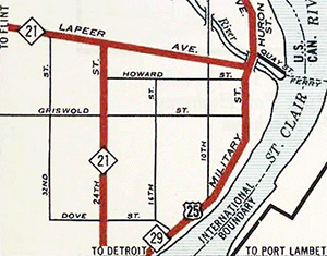 Oddly, starting in 1932 official maps show M-21 entering Port Huron via Lapeer Rd, but also depict it traveling along 24th St as well, meaning both Lapeer Ave and 24th St were both signed as legs of M-21, not a totally uncommon situation in the early days of the state highway system in Michigan. (Three-legged and multi-legged trunkline routes did exist in other areas in the 1920s and 1930s.) Two years later in 1934, M-146 shows up for the first time on official highway maps issued by the State Highway Dept with M-21 only shown along Lapeer Ave. Mentions of the M-146 designation do not appear in media reports until mid-1937! As many trunkline routes of this era were assigned route numbers sequentially as they were established, M-145 and M-147 were both established on August 31, 1931 indicating the M-146 designation was also like assigned at that same time, even if it was not immediately posted along the roadway. Oddly, starting in 1932 official maps show M-21 entering Port Huron via Lapeer Rd, but also depict it traveling along 24th St as well, meaning both Lapeer Ave and 24th St were both signed as legs of M-21, not a totally uncommon situation in the early days of the state highway system in Michigan. (Three-legged and multi-legged trunkline routes did exist in other areas in the 1920s and 1930s.) Two years later in 1934, M-146 shows up for the first time on official highway maps issued by the State Highway Dept with M-21 only shown along Lapeer Ave. Mentions of the M-146 designation do not appear in media reports until mid-1937! As many trunkline routes of this era were assigned route numbers sequentially as they were established, M-145 and M-147 were both established on August 31, 1931 indicating the M-146 designation was also like assigned at that same time, even if it was not immediately posted along the roadway.At the end of its existence as a trunkline designation, M-146 seems to fade into history. The coming of the Interstate highway system and other freeways supplants the role of M-146 as Port Huron's "West Belt" bypass route and the 24th St portion of the route is cancelled as a trunkline route in mid-October 1964. However, while I-94 took over a portion of the limited-access M-146 "West Belt Line" route constructed in the mid-1950s (which also included a new Blue Water Bridge approach), the portion from southwest of Water St to M-21/Lapeer Ave was ultimately retained as a state trunkline route—essentially a long set of freeway off- and on-ramps connecting I-94 with Lapeer Ave. This is where the ambiguity comes in. The M-146 designation may have been officially retired with the decommissioning of the 24th St segment when I-94 was completed and opened traffic, but the "Lapeer Connector" still appeared on some maps marked as M-146 for some years. Eventually, the Lapeer Connector became internally designated within MDOT as the "Connector 9" sometime in the 1990s. These unsigned and unknown outside of MDOT connector designations were redesignated in the 2006–08 timeframe to make them more closely match one of the highways they connect with. As such, "Connector 9" became "Connector 69" as the northern end of the route terminated at I-94/I-69 at the same time as the nearby "Connector 13"—the limited-access connector from I-94/I-69 to M-25/Pine Grove Ave at the foot of the Blue Water Bridge—was designated as "Connector 25." So, since no specific evidence has been found as to exactly when M-146 was decommissioned as a state trunkline highway designation, the October 15, 1964 date will be used here for lack of a more concrete timeframe. |
|
| History: | 1924 (July 1) |
| 1930 (Dec 2) |
|
| 1931 (May 19) |
|
| 1939 (Nov 15) |
|
| 1950 (Feb) |
|
| 1954 (Dec 6) |
|
| 1957 (June 24) |
|
| 1964 (Oct 14) |
|
| 1965 (May 26) |
|
| Controlled Access: | |
| Photographs: | |
| Weblinks: |
|
| Back to M-145 | Route Listings Home | On to Former M-147 |