M-196 is a former state trunkline route existing from c.1933 until c.1941–1954.
|
| Southern Terminus*: |
Cnr S Main St & 4th St at the Hersey Congregational Church in Hersey |
| Northern Terminus*: |
Cnr US-10 & 180th Ave north of Hersey, 3½ miles east of downtown Reed City |
| Final Length*: |
1.753 miles |
| Maps: |
 Route Map of Former M-196 Route Map of Former M-196 |
| Notes: |
* The termini and final length for M-196 reflect the beginning and ending of the route and its length as of the time of the route's decommissioning in the 1940s or 1950s. |
| |
Former M-196 was a short spur trunkline route established as a connection between the 1932 realignment of US-10 east of Reed City with downtown Hersey, a small village southeast of Reed City. Hersey has never been a large community, varying in population between 202 and 279 during the decades M-196 was in existence. In modern times, Hersey's population has hovered in the mid-300s. |
| |
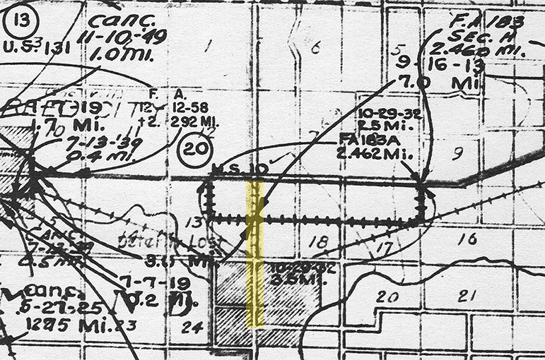
Oddly, Former M-196 seems to be a bit of a peculiarity among state trunkline routes in Michigan. The State Highway Department maintained a set of maps beginning in the 1920s through the early 1980s which depict every single state trunkline highway route ever established (and cancelled) along with attributes such as the length of each segment, the date of establishment and/or cancellation, and Federal Aid status. However, for some unknown reason, this information is omitted for Former M-196, which is highlighted in yellow on the snippet of the trunkline determination map below. Interestingly, M-196 is clearly shown on Michigan official highway maps from 1936 through mid-1941 when it was removed. The route continued to be depicted on other State Highway Department maps into the mid-1950s.
 |
| |
When any additional information on Former M-196 is unearthed, it will be included here. |
| History: |
c.1933 – While M-196 wasn't included on official highway maps until 1936—both those issued for general public consumption as well as internal departmental maps—several other trunkline highway routes in the 190s were first established in or around 1933. In the early 1930s, the State Highway Dept numbered many trunkline routes sequentially as they were established, so an establishment year of 1933 is assumed, based on the lack of establishment data on trunkline determination maps (see Notes above). |
| |
1935 (early Apr) – Construction on M-196 begins in early April with the primary earthmoving work occurring just south of the route's northern termunus at US-10 north of Hersey. A steam shovel is employed to make a cut through a high hill, a maximum depth of 24 feet, while some of the sand removed from the hill cut is being transported to the south for use as fill, with a maximum fill height of 18 feet. Two crews of 15 men each from the Osceola Reemployment Service office in Reed City—a Depression-era jobs initiative—are also working on the new highway route. One the earthmoving is complete and the sub-base and roadway base are down, a 20-foot wide oil aggregate (e.g. bituminous chip seal) will be applied to the roadway to give a hard surface throughout. |
| |
1935 (Sept 1) – The M-196 construction work is completed and the highway is fully opened to traffic. The project cost nearly $25,000, with the funding coming from the 1935 federal appropriation. |
| |
1941 (July 1) – The Summer 1941 official Michigan highway map issued to motorists is the last one to feature the route of M-196 depicted on the map. However, the route continues to be mentioned in local news reports through the rest of the decade. |
| |
1954 – A Michigan State Highway Dept drafted and issued map of Osceola Co from 1954 still has M-196 depicted on the spur route into Hersey. As the highway hasn't been depicted on the official highway map for nearly a decade-and-a-half at this point, it can be assumed the M-196 route markers have likely been removed in preparation for official cancellation of the route as a state trunkline highway. |
| Controlled Access: |
No portion of former M-196 upon decommissioning existed as freeway or expressway. |
| Photographs: |
|
| Weblinks: |
|
| |
|