Mackinac Island Street & Trail Map: Legend
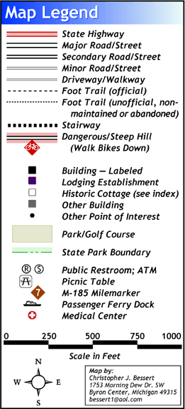
At right is the legend from the Mackinac Island map by Chris Bessert. This provides a good overview of the various types of features indicated on the map.
Roads are broken down by general "type" of roadway. Much of this classification has come from personal observation as to the quality, width and general use of the road or street and may not reflect any governmental classification system.
Foot Trails are also broken down into two categories: Official trails are those signed and indicated on most maps and generally receive some level of maintenance while the unofficial/non-maintained/abandoned trails are just that--pathways through the woods that appear to be used, but are not maintained by any authority and are generally not named or indicated on most maps.
Dangerous/Steep Hills are shown as a warning to bicyclists and pedestrians alike to watch out for conditions in these areas.
The State Park Boundary is also indicated, using all of the best possible sources of information. The boundaries include, as best as possible, all recent land aquisitions by the Mackinac Island State Park Commission (e.g. Sunset Rock).
Public Restrooms and ATMs are also indicated on the map to assist visitors in locating these vital services.
M-185 Milemarkers have been properly located on both sides of the map. It seems as if some of the milemarkers have been relocated in recent years to more accurately reflect their appropriate position--this map shows those new locations.