

| Back to Previous Route: Former M-168 |
 |
On to Next Route: Former M-178 |
| M-169 is a former state trunkline route existing: 1.) from December 2, 1930 until October 10, 1935, 2.) from November 12, 1940 until July 3, 1949, and 3.) from July 3, 1949 until 1950. |
|
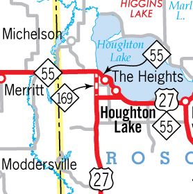
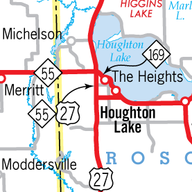
| Western Terminus*: | North jct of US-27 & M-55 (present-day cnr of M-55/Houghton Lake Dr & Old US-27) west of Houghton Lake Heights, Roscommon Co. |
| Eastern Terminus*: | M-55/Houghton Lake Dr at the cnr of Federal Ave at Houghton Lake Heights, Roscommon Co. |
| Final Length*: | 3.1 miles |
| Maps: | Route Map of Former M-169 Houghton & Higgins Lakes Area Trunkline History Map, 1939-Present |
| Notes: | * The termini and final length for M-169 reflect the beginning and ending of the route and its length as of the time of the route's most recent decommissioning in 1950. |
| M-169 has a rather interesting history: The route's first iteration, while lasting five years, was likely unsigned in the field and never connected to another physical state trunkline. The second iteration served as a connector route between two major trunklines and the third came about because the second iteration was subsumed under one of those trunklines and M-169 ended up "pivoting" and taking the place of a portion of the other of the two trunklines it connected! The end of the route came about when it became a business connection of that last trunkline it connected to on both ends. | |
| The first iteration of M-169 was to serve as a short, one-mile connecting trunkline route from the hamlet of Fostoria in extreme southern Tuscola Co along Goodrich Rd to the proposed M-36 running northerly from Lapeer through Mayville to Caro. Initially, this connecting route was denoted on internal State Highway Dept maps as "M-36 STUB," although it's certain this wasn't meant to be a signed designation in the field. The proposed M-36 in this area ran along Willits road on the Lapeer/Tuscola Co line, but while it was designated on December 2, 1930—the same day as the "M-36 STUB," later designated as M-169, proposed M-36 wasn't constructed or opened as a trunkline yet. Soon, the proposed M-36 was redesignated as a northerly extension of M-24 from Pontiac through Lapeer, Mayville and onward to Caro, with the official route still occupying the proposed corridor along Willits Rd in the Fostoria area, but now with a temporarily "Marked and Maintained" routing along present-day M-24 two miles to the east on Lapeer Rd. Within five years of its initial designation, however, the State Highway Dept had decided the original proposed M-36-turned-M-24 corridor along Willits Rd was never meant to be and on October 10, 1935 made it official: the Lapeer Rd route of M-24 was officially determined as that highway's route and the proposed M-24 was cancelled. Since this left the little one-mile, heretofore likely unsigned M-169 along Goodrich Rd between Forstoria and Willits Rds as an orphaned trunkline route so it, too, was also cancelled on October 10, 1935. | |
| NOTE: Before delving into the details of the second and third iterations of the route of M-169, it may be helpful to check out the Houghton & Higgins Lakes Area Trunkline History Map, 1939-Present, as the various routings of state trunklines in the area during the 1940s can be rather confusing to follow! | |
| The second iteration of M-169 actually gave a state trunkline designation to a connecting route that hadn't had one previously. When US-27 still passed around the south and east sides of Houghton and Higgins Lakes in the 1930s, in 1935 (as M-169 at Fostoria was being decommissioned), a new "cut-off" segment of M-55 at Houghton Lake Heights from existing M-55/Federal Ave northwesterly along present-day Houghton Lake Dr and Heightsview Dr back to existing M-55/Loxley St was assumed into the trunkline system. The former route of M-55 along Loxely St from US-27/Federal Ave northerly to present-day Heightsview Dr was kept as a state trunkline, although likely as a connector route without its own independent route designation. Then, in late-1940, US-27 was realigned at Houghton Lake Heights to contine westerly from Loxley St via Federal Ave to present-day Old US-27, then turn southerly back to its previous alignment at Emery Rd. An extension of the north-south portion of this new route was included, as plans were already in the works to move US-27 to a new westerly bypass of Houghton and Higgins Lakes in the near future—this would be the first segment of that bypass route, but would not be signed as such until the entire route was complete. Until then, it would act as a connector route between US-27 and M-55 and be designated as M-169. World War II came along and postponed the Houghton-Higgins Lake bypass project a few years, but work resumed in 1946 and when it was completed in July 1949, US-27 was rerouted to continue northerly from Federal Ave to supplant the M-169 designation to M-55 and then further north along the new bypass route to the west of the lakes to a point six miles south of Grayling. Although this meant the end of the second iteration of M-169, the designation merely "pivoted" on its northern terminus, which now became its new western terminus for the route's third iteration. To take traffic out of the congested Houghton Lake Heights district, where several turns were still required (along present-day Heightsview Dr), M-55 was rerouted to run southerly via US-27 along the former M-169 alignment to Federal Ave, then easterly to take the place of what had been US-27 along Federal Ave back to Houghton Lake Dr, then easterly to Prudenville. The former route of M-55 through Houghton Lake Heights between jct US-27 & M-55 (at present-day Old US-27) and M-55/Federal Ave was immediately designated as M-169. For whatever reason, though, the third iteration of M-169 was not to last long, for the State Highway Department redesignated M-169 as BUS M-55 (Business Route M-55) by the end of 1950, calling and end to the use of M-169 as a state trunkline route designation in the state. | |
Over its three iterations, the total route length of M-169 was:
|
|
| History: | 1930 (Dec 2) – The one mile of Goodrich Rd between Fostoria Rd at Fostoria in southern Tuscola Co and Willits Rd on the Tuscola/Lapeer Co line is officially determined as a state trunkline highway, initially designated M-36 STUB on interal State Highway Dept maps, but later noted as M-169. Willits Rd is simultaneously determined as the route of M-36 , although not physically opened as such at this time. |
| 1935 (Dec 2) – With the cancellation of the never-built trunkline route along Willits Rd on the Lapeer/Tuscola Co line (originally designated as M-36, then M-24) on this date, the one-mile spur route from Willits Rd into the community of Fostoria designated M-169 (but likely never signed in the field during the past five years) is similarly cancelled as a state trunkline route, thus ending the first iteration of M-169. | |
| NOTE: See the Houghton & Higgins Lakes Area Trunkline History Map, 1939-Present. | |
| 1940 (Nov 12) – In conjunction with a new alignment for US-27 to the southwest of Houghton Lake in Roscommon Co and in preparation for the eventual western bypass of Houghton and Higgins Lakes by US-27 in the future, a 2.1-mile long trunkline connector between the new alignment of US-27 (at present-day cnr of Old US-27 & Federal Ave southwest of Houghton Lake Heights) and M-55 (at present-day M-55/Houghton Lake Dr & Old US-27) is officially assumed into the trunkline system on this date and is designated as M-169. The actual highway is not yet constructed, however and "cutoff traffic" between the two routes continues to use Loxley St for now. | |
 1942 (Jan 28) – The former cutoff route between US-27 along Federal Ave and M-55 along present-day Heightsview Dr at Houghton Lake Dr is turned back to county control, likely signifying completion of the new M-169 cutoff route along present-day Old US-27—the route officially determined in November of 1940. M-169 is now assumed to be complete and open to traffic, as a gravel-surfaced highway.
For the moment, the M-169 connector helps facilitate traffic moments from US-27 nbd to M-55 wbd and from M-55 ebd to US-27 sbd. 1942 (Jan 28) – The former cutoff route between US-27 along Federal Ave and M-55 along present-day Heightsview Dr at Houghton Lake Dr is turned back to county control, likely signifying completion of the new M-169 cutoff route along present-day Old US-27—the route officially determined in November of 1940. M-169 is now assumed to be complete and open to traffic, as a gravel-surfaced highway.
For the moment, the M-169 connector helps facilitate traffic moments from US-27 nbd to M-55 wbd and from M-55 ebd to US-27 sbd. |
|
| 1945 (Late) – By late 1945, the entire 2.1-mile length of M-169 is fully paved throughout. | |
 1949 (July 3) – While construction had begun on the westerly bypass of Houghton and Higgins Lakes in June 1946 and it was opened to local traffic in segments at the end of 1947 and 1948, it is finally completed and opened to traffic all the way to its former route six miles south of Grayling on this date. The US-27 designation is extended northerly from the present-day intersection of Old US-27 & Federal Ave northerly 2.1 miles to completely replace the M-169 designation to M-55, then continues northerly past Houghton and Higgins Lakes toward Grayling. As the M-55 designation is rerouted southerly from the new US-27 junction (formerly the northern terminus of M-169) to follow US-27 (the former M-169) to Federal Ave at the former southern terminus of M-169 where it now turns easterly to run along Federal Ave (formerly US-27) back to M-55's former route on Houghton Lake Dr, the segment of the former M-55 between the new US-27 bypass and Federal Ave is redesignated as M-169. The M-169 designation essentially "pivots" on its former northern terminus, which now becomes its new western terminus (at present-day cnr of M-55/Houghton Lake Rd & Old US-27). M-169 now begins at US-27 and continues easterly via Houghton Lake Dr (including a short loop via present-day State Ave/Old M-55 BR), then present-day Heightsview Dr through "downtown" Houghton Lake Heights to Knapp Rd, and Houghton Lake Dr back to M-55 at Federal Ave where it now terminates. This becomes the third iteration of M-169. 1949 (July 3) – While construction had begun on the westerly bypass of Houghton and Higgins Lakes in June 1946 and it was opened to local traffic in segments at the end of 1947 and 1948, it is finally completed and opened to traffic all the way to its former route six miles south of Grayling on this date. The US-27 designation is extended northerly from the present-day intersection of Old US-27 & Federal Ave northerly 2.1 miles to completely replace the M-169 designation to M-55, then continues northerly past Houghton and Higgins Lakes toward Grayling. As the M-55 designation is rerouted southerly from the new US-27 junction (formerly the northern terminus of M-169) to follow US-27 (the former M-169) to Federal Ave at the former southern terminus of M-169 where it now turns easterly to run along Federal Ave (formerly US-27) back to M-55's former route on Houghton Lake Dr, the segment of the former M-55 between the new US-27 bypass and Federal Ave is redesignated as M-169. The M-169 designation essentially "pivots" on its former northern terminus, which now becomes its new western terminus (at present-day cnr of M-55/Houghton Lake Rd & Old US-27). M-169 now begins at US-27 and continues easterly via Houghton Lake Dr (including a short loop via present-day State Ave/Old M-55 BR), then present-day Heightsview Dr through "downtown" Houghton Lake Heights to Knapp Rd, and Houghton Lake Dr back to M-55 at Federal Ave where it now terminates. This becomes the third iteration of M-169. |
|
| 1950 – The third iteration of M-169 does not even last a year, as some time during 1950, the State Highway Dept decides to redesignate M-169 as BUS M-55 in its entirety through Houghton Lake Heights—a decision which makes a certain amount of sense, as the route begins and ends at M-55 and runs through the heart of Houghton Lake Heights. Thus, the third iteration of M-169 comes to a close. There has never been another state trunkline highway route in Michigan bearing the M-169 designation since. | |
| Controlled Access: | No portion of former M-169 upon decommissioning existed as freeway or expressway. |
| Photographs: | |
| Weblinks: |
|
| Back to Former M-168 | Route Listings Home | On to Former M-178 |