

Rationalization
The First Transfers
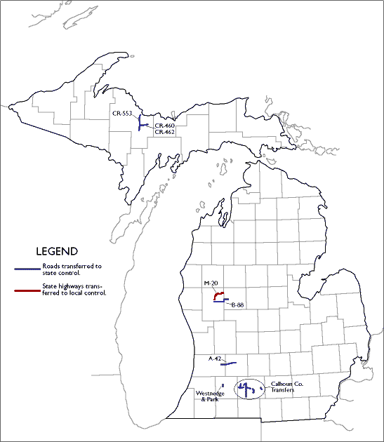 October 1, 1998 saw 120 miles of formerly county or municipal roads become
part of the state highway system under the Rationalization Process begun
in 1997. Most of these new highways were (eventually) fully integrated
into the state trunkline system, being assigned standard route numbers
(M-nn) instead of retaining their current names
or county-route numbers while being maintained by the state. In addition
to the 120 miles of highway transferred to the state, 24 miles of formerly
state routes were transferred back to county control in Newaygo County.
To view a full-sized version of the "thumbnail" map
on the right, click on the map.
October 1, 1998 saw 120 miles of formerly county or municipal roads become
part of the state highway system under the Rationalization Process begun
in 1997. Most of these new highways were (eventually) fully integrated
into the state trunkline system, being assigned standard route numbers
(M-nn) instead of retaining their current names
or county-route numbers while being maintained by the state. In addition
to the 120 miles of highway transferred to the state, 24 miles of formerly
state routes were transferred back to county control in Newaygo County.
To view a full-sized version of the "thumbnail" map
on the right, click on the map.
The 120 miles transferred are detailed in the following PDF document (listed by jurisdiction): Rationalization Chart: The First Transfers.
Subsequent Transfers
Since 1998, MDOT has continued to effect jurisdictional transfers of roadway miles, although most of the transfers have been from the state to local jurisdictions. These subsequent transfers have been outside the realm of the "Rationalization Process," however. These more recent transfers, along with the Rationalization transfers, can be found in the table on the Jurisdictional Transfers 1998-2002 page.